ATLAS of ANTIENT GEOGRAPHY by SAMUEL BUTLER 1843John McInnis Auctioneers,LLC4.5(505)See Sold PriceFeb 24, 2024
18TH C. ANTIQUE MAP: FRENCH & INDIAN WAR, FRAMEDThomaston Place Auction Galleries4.4(393)See Sold PriceFeb 24, 2024
Rand McNally Railroad Map Cabinet w/ 21 Railroad MapsRail & Road Auctions4.6(165)See Sold PriceMar 08, 2024
Keith Haring - Ink on New York Map, Best Buddies, Inscribed, Signed, and DatedSapphire Auction Gallery4.1(67)See Sold PriceMar 02, 2024
LATE 17TH C. FRENCH MAP OF THE NEW WORLD BY ALEXIS-HUBERT JAILLOT (1632-1712)Thomaston Place Auction Galleries4.4(393)See Sold PriceFeb 24, 2024
Central Railroad of New Jersey Map of Sandy Hook Route-ca. 1903JM Hobby Supply and Railroad Artifact Auctions4.4(127)See Sold PriceFeb 24, 2024
Lot of Six Mixed Atlas Box Cars-HO Scale-New in BoxJM Hobby Supply and Railroad Artifact Auctions4.4(127)See Sold PriceFeb 25, 2024
Rand McNally/Santa Fe Railroad Map of Iowa-1912JM Hobby Supply and Railroad Artifact Auctions4.4(127)See Sold PriceFeb 24, 2024
NICOLAES VISSCHER (NETHERLANDS, 1618-1709) MAP OF THE NEW WORLDThomaston Place Auction Galleries4.4(393)See Sold PriceFeb 24, 2024
17TH C. WORLD MAP BY NICOLAES VISSCHER (NETHERLANDS, 1618-1709)Thomaston Place Auction Galleries4.4(393)See Sold PriceFeb 24, 2024
Lot of Six Mixed Atlas Cabooses-HO Scale-New in BoxJM Hobby Supply and Railroad Artifact Auctions4.4(127)See Sold PriceFeb 25, 2024
SoldEdinburgh Firth' sea chart. Firth of Forth. Lothian &TITLE/CONTENT OF MAP: '[Edinburgh Firth] - To the Right Hon. James Earle of Perth Lord Chancellor of the Kingdom of Scotland. This chart is humbly dedicated by Capt. Greenvile Collins, Hydrographer toSee Sold Price
Edinburgh Firth' sea chart. Firth of Forth. Lothian &TITLE/CONTENT OF MAP: '[Edinburgh Firth] - To the Right Hon. James Earle of Perth Lord Chancellor of the Kingdom of Scotland. This chart is humbly dedicated by Capt. Greenvile Collins, Hydrographer toSee Sold Price
Edinburgh Firth' sea chart. Firth of Forth. Lothian &TITLE/CONTENT OF MAP: '[Edinburgh Firth] - To the Right Hon. James Earle of Perth Lord Chancellor of the Kingdom of Scotland. This chart is humbly dedicated by Capt. Greenvile Collins, Hydrographer toSee Sold Price
Edinburgh Firth. Firth of Forth sea chart. Lothian & Fife. COLLINS 1723 mapTitle: Edinburgh Firth. Firth of Forth sea chart. Lothian & Fife. COLLINS 1723 map Description: [Edinburgh Firth] - To the Right Hon. James Earle of Perth Lord Chancellor of the Kingdom of Scotland. TSee Sold Price
Edinburgh Firth. Firth of Forth sea chart. Lothian & Fife. COLLINS 1693 mapTitle: Edinburgh Firth. Firth of Forth sea chart. Lothian & Fife. COLLINS 1693 map Description: [Edinburgh Firth] - To the Right Hon. James Earle of Perth Lord Chancellor of the Kingdom of Scotland. TSee Sold Price
Collins: Antique Edinburgh Firth Sea Chart, 1774TITLE/CONTENT OF MAP: '[Edinburgh Firth] - To the Right Hon. James Earle of Perth Lord Chancellor of the Kingdom of Scotland. This chart is humbly dedicated by Capt. Greenvile Collins, Hydrographer toSee Sold Price
Sea Chart EDINBURGH FIRTH COASTING PYLOT CA 1700167. Sea Chart EDINBURGH FIRTH COASTING PYLOT CA 1700: Wood Block Print Chart of Edinburgh Firth By Capt. Greenville Collins, From his COASTING PYLOT, 1693 "To the Right Honorable James Earl of Perth,See Sold Price
Collins: Antique Sea Chart of the Edinburgh Firth, 1774Title/Content of Map: '[Edinburgh Firth] - To the Right Hon. James Earle of Perth Lord Chancellor of the Kingdom of Scotland. This chart is humbly dedicated by Capt. Greenvile Collins, Hydrographer toSee Sold Price
Collins: Antique Sea Chart Map of Edinburgh Firth, 1774[Edinburgh Firth] - To the Right Hon. James Earle of Perth Lord Chancellor of the Kingdom of Scotland. This chart is humbly dedicated by Capt. Greenvile Collins, Hydrographer to the King' This superbSee Sold Price
Firth of Murry' sea chart. MORAY FIRTH InvernessReserve Reduced! TITLE/CONTENT OF MAP: '[The Firth of Murry] - To the Rt Honble, my Lord Viscount Torbat, Lord Register of the Kingdom of Scotland, this map is most humbly dedicated & presented by CapSee Sold Price
Firth of Murry Sea ChartFirth of Murry' sea chart. MORAY FIRTH Inverness Cromarty. COLLINS, c1774 map Size: Approx 63.5 x 51.0cm, 25 x 20 inches (Large); Please note that this is a folding map. Please note that this lot hasSee Sold Price
Collins: Antique Sea Chart Map of Firth of Murry, 1774[The Firth of Murry] - To the Rt Honble, my Lord Viscount Torbat, Lord Register of the Kingdom of Scotland, this map is most humbly dedicated & presented by Capt. G. Collins, Hydroghe. to the King. 16See Sold Price
SoldTwo English sea charts, 5 color plates of shellsCapt. Greenville Collins: "Edinburgh Firth" and "Falmouth," as published in Great Britain's Coasting Pilot (orig. published in 1693, with later editions in the 18th century (these appear to be early 1See Sold Price
Collins: Firth of Murry Antique sea chart, 1774TITLE/CONTENT OF MAP: '[The Firth of Murry] - To the Rt Honble, my Lord Viscount Torbat, Lord Register of the Kingdom of Scotland, this map is most humbly dedicated & presented by Capt. G. Collins, HySee Sold Price
Sea Birds on Bass Rock, Firth of Forth, ScotlandSea Birds on Bass Rock, Firth of Forth, Scotland. 5.25 x 8See Sold Price
Sea Birds on Bass Rock, Firth of Forth, ScotlandSea Birds on Bass Rock, Firth of Forth, Scotland. 5.25 x 8See Sold Price
Blaeu (Johan and Cornelius) - Lothian and Linlitquo,the Firth of Forth either side of Edinburgh, from Lithligow to Dunbar, title cartouche lower left and armorial dedication cartouche upper right, engraved map with hand-colouring, 380 x 550mm., FrenchSee Sold Price
SoldScotland.- Collins (Capt. Greenville) [The MorayScotland.- Collins (Capt. Greenville) [The Moray Firth], sea chart with decorative cartouche in the upper right corner, engraving with some hand-colouring, sheet 495 x 590 mm. (19 1/2 x 23 1/4 in), laSee Sold Price
Gall & Inglis' Reduced Ordnance Map of Scotland. No.Title/Content of Map: Gall & Inglis' Reduced Ordnance Map of Scotland. No. 64. [Edinburgh / Firth of Forth] Date: c1910 Cartographer: Gall & Inglis Publisher: Gall & Inglis Size: 21.5Height - 27WidthSee Sold Price
SoldAlfred Edward Montague (English, ca. 1812-1883)Alfred Edward Montague (English, ca. 1812-1883) "Edinburgh from the Firth of Forth", and "River View of an English Town", pair of ink and wash drawings, second quarter 19th century, sight 5" x 8-3/4".See Sold Price
Alfred Edward Montague (English, ca. 1812-1883)Alfred Edward Montague (English, ca. 1812-1883) "Edinburgh from the Firth of Forth", and "River View of an English Town", pair of ink and wash drawings, second quarter 19th century, sight 5" x 8-3/4".See Sold Price
SoldHondius (Henricus) - A New Description of the Shyressecond issue of Timothy Pont's survey of south east Scotland, including Edinburgh and the Firth of Forth, strapwork title cartouche lower left, large arms upper right, compass rose and ships, engravedSee Sold Price
Sea Gulls on Bass Rock. C1890Sea Gulls on Bass Rock. C1890. Firth of Forth in the east of Scotland. Good contrast and tonality. Photographer: George Washington Wilson. 5.25 x 8 in.See Sold Price
Hondius (Henricus) - A New Description of the Shyresthe southern shore of the Firth of Forth including Edinburgh, with large decorative dedication cartouche and ships, upper right, strapwork title cartouche lower left, engraved map with original hand-cSee Sold Price
LARGE EARLY 18TH C. DUTCH CHART OF UPPER NORTH AMERICA, PIERRE MORTIER (1661-1711), FRAMEDThomaston Place Auction Galleries4.4(393)See Sold PriceFeb 24, 2024
West Indies Windward Lesser Antilles. Martinique (Belonging to France)Jasper524.5(9.9k)See Sold PriceFeb 27, 2024
Southern Africa Cape of Good Hope-Madagascar ADMIRALTY sea chart 1935 (1955) mapJasper524.5(9.9k)See Sold PriceFeb 28, 2024
Gulf of Guinea. Ghana Togo Benin Nigeria. ADMIRALTY sea chart 1928 (1954) mapJasper524.5(9.9k)See Sold PriceFeb 28, 2024
South Namibia coast. Walvis Bay-Orange River ADMIRALTY sea chart 1881 (1954) mapJasper524.5(9.9k)See Sold PriceFeb 28, 2024
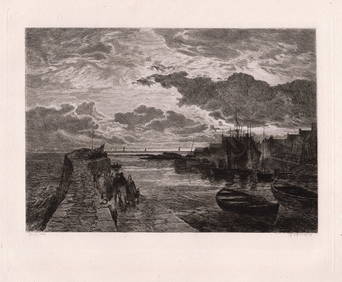
1879 Samuel Bough Cellardyke Harbour, Firth of Forth etching signedKCM Galleries4.7(164)See Sold PriceFeb 25, 2024