ATLAS of ANTIENT GEOGRAPHY by SAMUEL BUTLER 1843John McInnis Auctioneers,LLC4.5(505)See Sold PriceFeb 24, 2024
18TH C. ANTIQUE MAP: FRENCH & INDIAN WAR, FRAMEDThomaston Place Auction Galleries4.4(394)See Sold PriceFeb 24, 2024
Rand McNally Railroad Map Cabinet w/ 21 Railroad MapsRail & Road Auctions4.6(165)See Sold PriceMar 08, 2024
Keith Haring - Ink on New York Map, Best Buddies, Inscribed, Signed, and DatedSapphire Auction Gallery4.1(67)See Sold PriceMar 02, 2024
LATE 17TH C. FRENCH MAP OF THE NEW WORLD BY ALEXIS-HUBERT JAILLOT (1632-1712)Thomaston Place Auction Galleries4.4(394)See Sold PriceFeb 24, 2024
Central Railroad of New Jersey Map of Sandy Hook Route-ca. 1903JM Hobby Supply and Railroad Artifact Auctions4.4(127)See Sold PriceFeb 24, 2024
Lot of Six Mixed Atlas Box Cars-HO Scale-New in BoxJM Hobby Supply and Railroad Artifact Auctions4.4(127)See Sold PriceFeb 25, 2024
Rand McNally/Santa Fe Railroad Map of Iowa-1912JM Hobby Supply and Railroad Artifact Auctions4.4(127)See Sold PriceFeb 24, 2024
NICOLAES VISSCHER (NETHERLANDS, 1618-1709) MAP OF THE NEW WORLDThomaston Place Auction Galleries4.4(394)See Sold PriceFeb 24, 2024
17TH C. WORLD MAP BY NICOLAES VISSCHER (NETHERLANDS, 1618-1709)Thomaston Place Auction Galleries4.4(394)See Sold PriceFeb 24, 2024
Lot of Six Mixed Atlas Cabooses-HO Scale-New in BoxJM Hobby Supply and Railroad Artifact Auctions4.4(127)See Sold PriceFeb 25, 2024
SoldMatthaus Seutter (1678-1757), "Diversi Globi Terr AquelMatthaus Seutter (1678-1757), "Diversi Globi Terr Aquel statione vartante et visu intercedence. Ambos Polos. Orthograpihic Prospectus - Quibus Addit promutatione horizontis. Conventia relation" c. 174See Sold Price
SoldTwo Maps by Matthaus Seutter (1678-1757), "AccurataTwo Maps by Matthaus Seutter (1678-1757), "Accurata Delineatio Celeberrimae Regionis Ludocianae vel Gallice Louisiane al Canadae et Floridae adpellatione in Septemtrionali America, Mississippi, St. LoSee Sold Price
SoldMATTHAUS SEUTTER (LUXEMBOURG C. 1730) MAPMap of fort and city of Luxembourg. Hand colored engraving. Dimensions: (Frame) H 20.75" x W 24.25", (Sight) H 19.75" x W 23" Condition: Foxing. Age toning.See Sold Price
SoldMatthaus Seutter (1678-1757), "Nov Orbis sive AmericaMatthaus Seutter (1678-1757), "Nov Orbis sive America Septentrionalis divisa per fua Regna Provine: et lnsul," 1760, Augsburg, hand colored, H. - 8 in., W. - 10 in.See Sold Price
SoldMatthaus Seutter (1678-1757)," Pensylvania Nova JerseyMatthaus Seutter (1678-1757)," Pensylvania Nova Jersey et Nova York cum regionibus ad fluvium Delaware," hand colored, H.- 25 1/2in., W.-21 1/2 in.See Sold Price
SoldMatthaus Seutter Cartographic Engraving"Sphaerae Artificiales", Matthaus Seutter, hand colored engraving by Johann Michael Probst, Augsburg. 23.5"h x 29"wSee Sold Price
SoldMATTHAUS SEUTTER HAND COLORED ENGRAVING: MAP OF VENICEMatthaus Seutter hand colored copper engraving showing a map of Venice, circa 1730. General birds' eye view with coat of arms and two main views of the Piazza San Marco and the Piazzetta. Matted and uSee Sold Price
SoldGeorg Matthaus Seutter, Framed Map of CreteFramed map of Crete by map maker Georg Matthaus Seutter. Titled: Insula Creta nunc Candia, Date : Augsburg, 1741. Hand-colored map divided into its four territories, and the islands to its north. TheSee Sold Price
SoldMatthaus Seutter (1678-1757), "Tabula NovissimaMatthaus Seutter (1678-1757), "Tabula Novissima Regnorum Anglieae Scottiae Hiberniae,"18th c., hand colored, H. - 23 in., W. - 19 in.See Sold Price
SoldGeorg Matthaus Seutter (German, 1678-1757) 17C MapGeorg Matthaus Seutter (German, 1678-1757) 17th century map. Nova Belgii America Septentrionali hand colored engraved map. In good condition, not glued down, tape hinge at top, there is a quarter inchSee Sold Price
SoldAntique Map Georg Matthaus Seutter 18th C.18th C. antique map is third state of Seutter's map based on Jansson's map of 1651. Hand colored and embellished with decorations and animal figures. Shows boundaries of Massachusetts, New England, NeSee Sold Price
SoldMatthaus Seutter, pair allegorical engravingsMatthaus Seutter, pair allegorical engravings, Matthaus Seutter (German, 1678-1757), "STATUA REGUM EUROPAEORUM P.C. N. NOMINA CONTINENS." and "ICON SYNOPTICA SAC. ROM. IMP. ELECTORUM. DUCUM. PRINCIPUMSee Sold Price
SoldMatthaus Seutter hand-colored mapMatthaus Seutter (German 1678-1757)- ''Tabula Comitatus Hollandiae... Provinc, ultraiectina et maxima pars Geldriae''- hand-colored map, cartouche top right, Texel map top left. 20 x 22 1/2''See Sold Price
SoldMatthaus Seutter, Map, c. 1740Matthaus Seutter, "Mappa Geographica Regionem Mexicanam et Floridam...", Augsburg, c. 1740, hand-colored, with inset maps of Havana, Portobell, Cartagena and Vera Cruz, with vignettes of a sea battleSee Sold Price
SoldMatthaus Seutter Map of Brazil 1735Matthaus Seutter Map of Brazil, 1735. Map titled "Recens elaborate Mappa Geographica Regni Brasiliae in America Meridionali". Map measures 23.75" x 20" sheet size. Unframed, loose and not glued or mouSee Sold Price
SoldMatthaus Seutter, map OostendeMatthaus Seutter, map Oostende, Matthaus Seutter (German, 1678-1757), "Ostende", c. 1740, hand-colored engraving, 20"h x 23"w (sight), 31"h x 34"w (frame size), matted and framed under glass ProvenancSee Sold Price
SoldGeorge Matthaus Seutter, Map of RomeColored engraving. George Matthaus Seutter (1678-1757). Approx. 23" H x 26" W framed. (6090)See Sold Price
SoldMatthaus Seutter MapMatthaus Seutter, "Mappa Geographica Regionem Mexicanam et Floridam...", Augsburg, c. 1740, hand-colored, with inset maps of Havana, Portobell, Cartagena and Vera Cruz, with vignettes of a sea battleSee Sold Price
SoldGrp: 3 Matthaus Seutter Maps of Italy Tuscany ManMatthaus Seutter (1678-1757) Group of three hand colored maps including a map of Tuscany, a map of Mantua, and a map of Modena. All with exquisitely detailed cartouches featuring groups of figures. SKSee Sold Price
SoldMATTHAUS SEUTTER (GERMAN, 1678-1757) MAP OF BRAZILMATTHAUS SEUTTER (GERMAN, 1678-1757) MAP OF BRAZIL, hand-colored engraving on paper, titled "Recens Elaborata Mappa Geographica Regni Brasillae in America Meriodionali maxime celebris accurate delineaSee Sold Price
SoldMatthaus Seutter (1678-1757), "Novissima etMatthaus Seutter (1678-1757), "Novissima et Accuratissima Regnorum Hispaniae et Portugalliae..," 18th c., hand colored, H. - 21 1/8 in., W. -24 1/2 in.See Sold Price
SoldMaps, Matthaus Seutter and Frederick de Wit(lot of 2) Matthaus Seutter (German, 1678-1757), "Europa Religionis Christianae," copper engraved map with hand coloring and Frederick De Wit (Dutch,1630-1706), "Novissima et Accuratissima totius ItalSee Sold Price
SoldMatthaus Seutter map of the Americas Austrian (167Matthaus Seutter map of the Americas Austrian (1678-1757) "Novus Orbis Sive America" hand-colored engraving. (Good condition, trimmed) paper size: H20 1/2" W24"See Sold Price
SoldMap, Matthaus Seutter IIIMatthaus Seutter III (German, 1678-1757), "Praga Celeberrima et Maxima Totius Bohemiae Metropolis," circa 1720, hand-colored engraving, image (sight): 19.75"h x 22.75"w, overall (with mat/unframed): 2See Sold Price
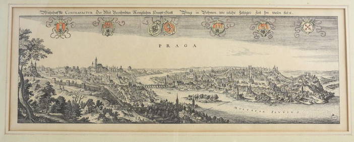
Matthaus Merian (Swiss 1593-1650) Engraving Panoramic View of PragueGlobal Auctions Company4.3(36)See Sold PriceMar 03, 2024
18th Century Hess Germany Hand colored Engraved MapGlobal Auctions Company4.3(36)See Sold PriceMar 03, 2024
After Matthaus Merian (1593-1650), Engraving with hand colouring, Ander Prost: der Kirche de R. P.Claydon Auctioneers Ltd4.3(125)See Sold PriceFeb 26, 2024
NEUERÖFFNETE HIMMELSSCHULE, ANDACHTS- UND TUGENDSÜBUNGENHargesheimer Kunstauktionen Duesseldorf4.5(137)See Sold PriceMar 07, 2024
JAN LIEVENS (UMKREIS/SCHULE)Hargesheimer Kunstauktionen Duesseldorf4.5(137)See Sold PriceMar 09, 2024