ATLAS of ANTIENT GEOGRAPHY by SAMUEL BUTLER 1843John McInnis Auctioneers,LLC4.6(502)See Sold PriceFeb 24, 2024
18TH C. ANTIQUE MAP: FRENCH & INDIAN WAR, FRAMEDThomaston Place Auction Galleries4.4(386)See Sold PriceFeb 24, 2024
Rand McNally Railroad Map Cabinet w/ 21 Railroad MapsRail & Road Auctions4.6(165)See Sold PriceMar 08, 2024
Keith Haring - Ink on New York Map, Best Buddies, Inscribed, Signed, and DatedSapphire Auction Gallery4(67)See Sold PriceMar 02, 2024
LATE 17TH C. FRENCH MAP OF THE NEW WORLD BY ALEXIS-HUBERT JAILLOT (1632-1712)Thomaston Place Auction Galleries4.4(386)See Sold PriceFeb 24, 2024
Central Railroad of New Jersey Map of Sandy Hook Route-ca. 1903JM Hobby Supply and Railroad Artifact Auctions4.4(126)See Sold PriceFeb 24, 2024
Lot of Six Mixed Atlas Box Cars-HO Scale-New in BoxJM Hobby Supply and Railroad Artifact Auctions4.4(126)See Sold PriceFeb 25, 2024
Rand McNally/Santa Fe Railroad Map of Iowa-1912JM Hobby Supply and Railroad Artifact Auctions4.4(126)See Sold PriceFeb 24, 2024
NICOLAES VISSCHER (NETHERLANDS, 1618-1709) MAP OF THE NEW WORLDThomaston Place Auction Galleries4.4(386)See Sold PriceFeb 24, 2024
17TH C. WORLD MAP BY NICOLAES VISSCHER (NETHERLANDS, 1618-1709)Thomaston Place Auction Galleries4.4(386)See Sold PriceFeb 24, 2024
Lot of Six Mixed Atlas Cabooses-HO Scale-New in BoxJM Hobby Supply and Railroad Artifact Auctions4.4(126)See Sold PriceFeb 25, 2024
De Wit Map of west AfricaDe Wit, Frederick. Barbariae Guineae Maritimi... Engraved map with original hand color. Amsterdam, c. 1675. 21" x 25" sheet. This decorative sea chart of the Barbary and Guinea coasts extends to incluSee Sold Price
SoldDe Wit Map of Africa ca. 1685Frederick de Wit (ca. 1630 – 1706), "Totius Africae Accuratissima Tabula," Amsterdam, ca. 1685. Hand colored map of Africa. African animals are included throughout the continent, and the decoraSee Sold Price
SoldDe Wit Map of AfricaTotius Africa Accuratissima Tabula. Frederick de Wit (1629/1630-1706). Engraved map with original hand color. Amsterdam, c. 1660. 19 1/4 x 23 inches visible, 24 3/4 x 28 1/2 inches framedSee Sold Price
De Lisle: Map of West Africa, 1745This eighteenth century map shows West Africa, divided roughly into Barbarie (Barbary), Nigritie, and Guinee (Guinea). The Azores, Canary islands and the Cape Vedre islands are also marked. ReflectingSee Sold Price
De Wit / Renard Map of the West IndiesDe Wit / Renard. Indiarum Occidentalium Tractus Littorales cum Insulis Caribicis / Pascaert van Westindien ende Caribise Eylanden. Engraved map with original hand color. Amsterdam, 1715. 21” x 25 1/See Sold Price
de l'Isle: Antique Map of West Africa, 1745This eighteenth century map shows West Africa, divided roughly into Barbarie (Barbary), Nigritie, and Guinee (Guinea). The Azores, Canary islands and the Cape Vedre islands are also marked. ReflectingSee Sold Price
SoldEarly Dutch map of Africa by Frederick De WitEarly Dutch map of Africa by Frederick De Wit Early Dutch map of Africa by Frederick De Wit Amsterdam, circa 1680TOTIUS AFRICAE ACCURATISSIMAcolored engraving, framed, marked and titled: lower leftimaSee Sold Price
de l'Isle: Antique Map of French West Africa, 1727This large eighteenth century map shows the coast of West Africa and its hinterland between Ras Nouadhibou (marked with its French name of Cap Blanc) which is today on the border between Mauritania anSee Sold Price
MAP, Western Africa, De WitWestern Africa. Frederick de Wit, Guinea, 1680 (circa). Hand Color. Elegantly engraved map covering the coast from Sierra Leone to Gabon. The land is filled with elephants, lions, leopards and monkeysSee Sold Price
SoldEarly map of Africa, Frederick de Wit17th or 18th century. hand colored engraving. H19" W22 7/8"See Sold Price
L'afrique Francoise Ou Du Senegal, French W. Africa MapL'afrique Francoise Ou Du Senegal'. French West Africa. 1727 Map by Guillaume de l'Isle. Approx 52.0 x 65.0cm, 20.5 x 25.5 inches (Large); Please note that this is a folding map. Large antique 18th ceSee Sold Price
D'Anville and Tardieu Maps of West AfricaAnville (Jean Baptiste Bourguignon d') Carte Particulière de la Côté Occidentale de l'Afrique, depuis le Cap Blanc jusqu'au Cap de Verga,coastal chart and river map of West Africa, engraved maSee Sold Price
SoldAnville (J B B d') West AfricaAnville (Jean Baptiste Bourguignon d') Carte Particulière de la Côté Occidentale de l'Afrique, depuis le Cap Blanc jusqu'au Cap de Verga,coastal chart and river map of West Africa, engraved maSee Sold Price
Antique Map Print - Theodor de Bry - Map Of Congo Durch Matthias BeckerThe Most Important Maps of West Africa Published in the Sixteenth Century. Fine example of Pigafetta's map of West Africa, from De Bry's Petit Voyages. Pigafetta's map of Africa based on the exploratiSee Sold Price
SoldDUTCH MAP OF AFRICA AFTER FREDERICO DE WITTotius Africae Accuratissima antique partially hand colored engraving, framed, 19 1/2" x 23 1/2" (sight).See Sold Price
SoldDanckerts (Justus) Novissima et Perfectissima AfriDanckerts (Justus) Novissima et Perfectissima Africae Descriptio ...,Africa, with decorative title lower left showing African people, lions, and elephants, based on De Wit's map of 1680, engraSee Sold Price
SoldOttens (Reinier and Josua) Cimbebas et Caffariæ LiOttens (Reinier and Josua) Cimbebas et Caffariæ Littora a Catenbela ad Promontorium Bonæ Spei,Southern Africa, north oriented to the left, a later version of a De Wit map with inset plan of thSee Sold Price
SoldGiovanni Battista Ramusio Map of West Africa 1606Giovanni Battista Ramusio (1485-1557), "Parte De L'Africa," Venice, 1606. Woodcut map of part of West Africa. The delicate detail of the map includes illustrations of sea Monsters, ships, African peopSee Sold Price
SoldBellin: Antique Map of West Africa, 1757Title/Content of Map: 1757 Bellin Map of West Africa -- Carte du Golfe de Guinee Et les Costes comprises entre le Cap Formosa et le Cap de Lopes Consalvo Date Printed: 1757, Paris Cartographer: J BellSee Sold Price
SoldLarge map of West Africa c.1700Heading: (Africa) Author: De l'Isle, Guillaume Title: Carte de la Barbarie de la Nigritie et de la Guinée Place Published: Paris Publisher: Date Published: c.1700 Description:See Sold Price
Poirson/Tardieu: Antique Map of West Africa, 1803Map: Carte de la Cote Occidentale de l’Afrique, Depuis le Cap Blanc Jusqu’a La Riv. De Serra Leonne Cartographer: Poirson//Tardieu Place & Date: Paris / 1803/1804 Size: 15" x 16 3/8" Condition: foSee Sold Price
SoldFrederick de wit World mapCartographer: Frederick de Wit Title: [Map 1] Nova Orbis Tabula, in Lucem Edita [in a set with Map 2] Nova Totius Europae [and Map 3] Nova Totius Asiae [and Map 4] Nova Totius Africa [and Map 5] NovaSee Sold Price
Bellin: Antique Chart Map of West Africa, 1759Map: Carte de la Coste Occidentale d'Afrique Depuis le Cap Blanc Jusqu'a a Tanit Date Printed: 1759 Cartographer: Bellin, Jacques Nicolas Size: 6 x 9 Condition: Very good Small chart of the African coSee Sold Price
Map west coast Africa from Gabon to Namibia, 1760,CARTE DU CONGO EN GENERAL OU DE LA BASSE GUINEE Very beautiful detailed map of 1760 circa by the French geographer Brion de la Tour featuring the west coast of Africa from the Gabon to Namibia. The maSee Sold Price
WEST AFRICA Niger/Gambia rivers tribes towns. 'Pays des Negres'. MALLET 1683 mapJasper524.5(9.8k)See Sold PriceFeb 28, 2024
NORTH & WEST AFRICA. Sahara Niger river 'Zaara ou le Desert'. MALLET 1683 mapJasper524.5(9.8k)See Sold PriceFeb 28, 2024
AFRICA. French West Africa. Rio de Oro Rio Muni Nigeria. BARTHOLOMEW 1952 mapJasper524.5(9.8k)See Sold PriceFeb 28, 2024
Coste Occidentale d’Afrique…' Arguin Bay Cap Blanc Mauritania. BELLIN 1746 mapJasper524.5(9.8k)See Sold PriceFeb 28, 2024
La Barbarie de la Nigritie et de la Guinée'. West Africa. DE L’ISLE 1745 mapJasper524.5(9.8k)See Sold PriceFeb 28, 2024
Carte de la Guinée, contenant…'. Guinea & Cape Verde islands. BONNE 1771 mapJasper524.5(9.8k)See Sold PriceFeb 28, 2024
Coste Occidentale d’Afrique'. Bay of Arguin, Mauritania. BELLIN/SCHLEY 1747 mapJasper524.5(9.8k)See Sold PriceFeb 28, 2024
Côte occidentale de l'Afrique. W Africa.Senegal Gambia rivers.D’ANVILLE 1751 mapJasper524.5(9.8k)See Sold PriceFeb 28, 2024
WEST AFRICA. Guinea. Nigeria Ghana Benin Togo Sierra Leone. MALLET 1683 mapJasper524.5(9.8k)See Sold PriceFeb 28, 2024
WEST CENTRAL AFRICA. Congo Angola Gabon Cameroon Sao Tome. MALLET 1683 old mapJasper524.5(9.8k)See Sold PriceFeb 28, 2024
Coste Occidentale d’Afrique…' West Africa. Gulf of Guinea. BELLIN 1746 mapJasper524.5(9.8k)See Sold PriceFeb 28, 2024
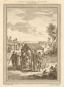
West Africa. Shrines of the Kings of Guinea, from Bry. Heads on stakes 1747Jasper524.5(9.8k)See Sold PriceFeb 28, 2024
Oiseaux de Guinée'. West African birds. Parrots. Cape Coast eagle 1748 printJasper524.5(9.8k)See Sold PriceFeb 28, 2024
Partie Occidentale de l’Afrique. West Africa coast Canary islands BONNE 1788 mapJasper524.5(9.8k)See Sold PriceFeb 28, 2024
Suite de la Coste de Guinée'. Ghana Togo Benin coast. BELLIN/SCHLEY 1748 mapJasper524.5(9.8k)See Sold PriceFeb 28, 2024
FRENCH WEST AFRICA Nigeria Gold Coast Rio de Oro Portuguese Guinea 1912 mapJasper524.5(9.8k)See Sold PriceFeb 28, 2024
Carte de la Haute et de la Basse Guinée. Gulf of Guinea Africa. BONNE 1780 mapJasper524.5(9.8k)See Sold PriceFeb 28, 2024
Cottonier & plantes de Guinée'. Cotton Cassava manioc potato. West Africa 1747Jasper524.5(9.8k)See Sold PriceFeb 28, 2024
West Africa. Kingfish Swordfish Gillbacker sea catfish. Fetish tree. SCHLEY 1748Jasper524.5(9.8k)See Sold PriceFeb 28, 2024
Partie Occidentale de l'Ancien Continent… W Africa Macaronesia. BONNE 1780 mapJasper524.5(9.8k)See Sold PriceFeb 28, 2024
Coste Occidentale d’Afrique…' Namibia South Africa Angola coast BELLIN 1746 mapJasper524.5(9.8k)See Sold PriceFeb 28, 2024
L'Afrique Françoise ou du Senegal'. French West Africa. DE L’ISLE 1727 mapJasper524.5(9.8k)See Sold PriceFeb 28, 2024