ATLAS of ANTIENT GEOGRAPHY by SAMUEL BUTLER 1843John McInnis Auctioneers,LLC4.6(502)See Sold PriceFeb 24, 2024
18TH C. ANTIQUE MAP: FRENCH & INDIAN WAR, FRAMEDThomaston Place Auction Galleries4.4(386)See Sold PriceFeb 24, 2024
Rand McNally Railroad Map Cabinet w/ 21 Railroad MapsRail & Road Auctions4.6(165)See Sold PriceMar 08, 2024
Keith Haring - Ink on New York Map, Best Buddies, Inscribed, Signed, and DatedSapphire Auction Gallery4(67)See Sold PriceMar 02, 2024
LATE 17TH C. FRENCH MAP OF THE NEW WORLD BY ALEXIS-HUBERT JAILLOT (1632-1712)Thomaston Place Auction Galleries4.4(386)See Sold PriceFeb 24, 2024
Central Railroad of New Jersey Map of Sandy Hook Route-ca. 1903JM Hobby Supply and Railroad Artifact Auctions4.4(126)See Sold PriceFeb 24, 2024
Lot of Six Mixed Atlas Box Cars-HO Scale-New in BoxJM Hobby Supply and Railroad Artifact Auctions4.4(126)See Sold PriceFeb 25, 2024
Rand McNally/Santa Fe Railroad Map of Iowa-1912JM Hobby Supply and Railroad Artifact Auctions4.4(126)See Sold PriceFeb 24, 2024
NICOLAES VISSCHER (NETHERLANDS, 1618-1709) MAP OF THE NEW WORLDThomaston Place Auction Galleries4.4(386)See Sold PriceFeb 24, 2024
17TH C. WORLD MAP BY NICOLAES VISSCHER (NETHERLANDS, 1618-1709)Thomaston Place Auction Galleries4.4(386)See Sold PriceFeb 24, 2024
Lot of Six Mixed Atlas Cabooses-HO Scale-New in BoxJM Hobby Supply and Railroad Artifact Auctions4.4(126)See Sold PriceFeb 25, 2024
1829 Carte Itinéraire et Politique d'Europe...Carte Itinéraire et Politique d'Europe d'après les derniers traités de paix, Avec les plans des principales villes d'Europe. By: Nicolas Maire Date: 1829 (Published) Paris Dimensions: 29.5 x 42.25See Sold Price
1829 Carte Itinéraire et Politique d'Europe...Carte Itinéraire et Politique d'Europe d'après les derniers traités de paix, Avec les plans des principales villes d'Europe. By: Nicolas Maire Date: 1829 (Published) Paris Dimensions: 29.5 x 42.25See Sold Price
Carte Politique Et Itineraire De L'Europe...1807 map of Europe: “CARTE POLITIQUE ET ITINÉRAIRE DE L'EUROPE ET DE L'EMPIRE FRANCAIS EN 1807 “by Hyacinthe Langlois. Measurement approximate: 19” x 14.5”. Please note that this lot has a coSee Sold Price
SoldHyacinthe Langlois: Carte Politique De L'europe, 18071807 map of Europe: “Carte Politique Et Itinéraire De L'europe Et De L'empire Francais en 1807 “by Hyacinthe Langlois. Engraved By: D. Derveaux. Measurement approximate: 19” x 14.5”. Please nSee Sold Price
Carte Politique De L'Europe Et De L'Empire FrancaisMap: Carte Politique Et Itineraire De L'europe Et De L'empire Francais en 1807 Maker: Hyacinthe Langlois Material: Wooden frame Date: Late 1800's, early 1900's Size: 19 x 14.25 inches Please note thatSee Sold Price
SoldHand Colored Map of Europe, Early 19th C19th Century hand clored Map “Carte Politique et Itineraire de L’Europe et de L’Empire Francais en 1807”. By Chex Hyacinethe Langlois, Libraire, engraved by D. Derveaux, del. On laid paper. NoSee Sold Price
Hand Colored Map of Europe, Early 19th C19th Century hand clored Map "Carte Politique et Itineraire de L'Europe et de L'Empire Francais en 1807". By Chex Hyacinethe Langlois, Libraire, engraved by D. Derveaux, del. On laid paper. Not examinSee Sold Price
Physical and political map of Central Europe. 1871.Physical and political map of Central Europe. Austria, Prussia North and South Germany. Netherlands/Europe. 1871.Print from steel engraving titled „Carte physique et politique de L‘ Europe centralSee Sold Price
Map of European Turkey. 1854.Print of hand colored steel engraving titled „Carte Physique et Politique de Turque D’Europe“.Drawn by L. Dussieux.Engraved by unknown.From „Atlas General De Geographie physique, politique etSee Sold Price
Map of Europe. 1854.Print of hand colored steel engraving titled „Carte Geographique et Politique de L’Europe”.Drawn by L. Dussieux. Engraved by unknown.From „Atlas General De Geographie physique, politique et hiSee Sold Price
A. H. Brue: Carte Physique et Politique L'ASIE, 1829A. H. Brue: Carte Physique et Politique L'ASIE. Asia Map. 1829. Size: 88 x 64 cm Please note that this lot has a confidential reserve. When you leave a bid in advance of the auction, submit your maximSee Sold Price
SoldFrench Lithographic Map of 1807 EuropeFrench lithographic map of 1807 Europe, coat of arms and title to the upper left corner reads in French ‘Carte politburo et itineraire de L’Europe et du L’Empire Francais en 1807’, legend to lSee Sold Price
SoldHand Colored Map of Europe, Early 19th C19th Century hand clored Map “Carte Politique et Itineraire de L’Europe et de L’Empire Francais en 1807”. By Chex Hyacinethe Langlois, Libraire, engraved by D. Derveaux, del.See Sold Price
SoldEurope.- Traux (Maximilian de) Carte Generale etEurope.- Traux (Maximilian de) Carte Generale et Itineraire de L'Europe Divisee en tous ses Etats apres Le Congres de Vienne, large folding map of Europe, with large calligraphic title in the upper leSee Sold Price
SoldBRUÉ, Adrien Hubert - Carte physique et politiqueBRUÉ, Adrien Hubert - Carte physique et politique de l'Asie. Paris, J. Goujon et J. Andriveau, 1829. Carte rehaussée. 617 x 890 mm. Traces de plis. Jointes: - de nomSee Sold Price
Andriveau: Antique Map of Europe, 1843Map: Carte physique et politique de l’Europe Publication Date: 1843 Cartographer: Gilbert Gabriel Benjamin Andriveau Publisher: ANDRIVEAU-GOUJON Size: Wall size – 38.50 H x 50.50 W Inches par AndrSee Sold Price
Andriveau-Goujon: Antique Map of Europe, 1843Title/Content of Map: Carte physique et politique de l'Europe Date Printed: 1843 Cartographer: Gilbert Gabriel Benjamin Andriveau Publisher: ANDRIVEAU-GOUJON 1843 PARIS Size: Wall size – 38.50 H x 5See Sold Price
Map of Holland and Belgium. Europe. 1854.Print of hand colored steel engraving titled „Carte Physiquen et Politique de la Hollande et de la Belgique”.Drawn by L. Dussieux.Engraved by unknown.From „Atlas General De Geographie physique,See Sold Price
Map of Italy. Europe. 1854.Print of hand colored steel engraving titled „Carte Physique et Politique de L’Italie“.Drawn by L. Dussieux.Engraved by unknown.From „Atlas General De Geographie physique, politique et historiSee Sold Price
Andriveau-Goujon: Antique Map of Europe, 1843Map: Carte physique et politique de l’Europe Publication Date: 1843 Authors: ANDRIVEAU-GOUJON, Gilbert Gabriel Benjamin Andriveau, edited by FLAHAUT, P. with P. ROUSSET Publisher: ANDRIVEAU-GOUJON SSee Sold Price
Map of Prussia. Europe. 1854.Print of hand colored steel engraving titled „Carte Physiquen et Politique de la Prusse”.Drawn by L. Dussieux.Engraved by unknown.From „Atlas General De Geographie physique, politique et historiSee Sold Price
Map of The Spain and Portugal. Europe. 1871.Physical and political map of The Spain and Portugal. Europe. 1871.Print from steel engraving titled „Carte physique et politique de L‘ Espagne et du Portugal“.Author/compiler - MM. Drioux et ChSee Sold Price
Map of Switzerland. Europe. 1854.Print of hand colored steel engraving titled „Carte Physiquen et Politique de la Suisse”.Drawn by L. Dussieux.Engraved by unknown.From „Atlas General De Geographie physique, politique et historiSee Sold Price
Map of Spain and Portugal. Europe. 1854.Print of hand colored steel engraving titled „Carte physique et politique de L’Espagne et du Portugal“.Drawn by L. Dussieux.Engraved by unknown.From „Atlas General De Geographie physique, poliSee Sold Price
Map of St. Kitts and Nevis Depot de la Marine, Paris, 1758Global Auctions Company4.3(36)See Sold PriceMar 03, 2024
Two (2) Antique 18th C. Copper Engraved Framed Maps - America & EuropeMagnusson Art Group4.5(46)See Sold PriceMar 14, 2024
Van Houtte - Lady's Slipper OrchidTrillium Antique Prints & Rare Books4.5(30)See Sold PriceFeb 24, 2024
Railways & Transport.- [Prospectus] The Dorking, Brighton, and Arundel Atmospheric Railway, byForum Auctions4.3(52)See Sold PriceFeb 29, 2024
Van Houtte (Pub) C1860 Pair of Folio Greenhouse Prints. BelgiumAlbion Auctions4.6(336)See Sold PriceMar 07, 2024
1764 Bellin Chart of Three South Haitian Bays -- Carte des Bayes du Mesle des Flamands et deJasper524.5(9.8k)See Sold PriceFeb 27, 2024
Carte de la Barbarie… l'empire de Maroc… North Africa Morocco. LAPIE 1829 mapJasper524.5(9.8k)See Sold PriceFeb 28, 2024
La Barbarie de la Nigritie et de la Guinée'. West Africa. DE L’ISLE 1745 mapJasper524.5(9.8k)See Sold PriceFeb 28, 2024
Carte de l'Afrique propre, de la Numidie… North Africa. LAPIE 1829 old mapJasper524.5(9.8k)See Sold PriceFeb 28, 2024
LISZT FRANZ: (1811-1886)International Autograph Auctions Europe S.L.4.5(52)See Sold PriceMar 13, 2024
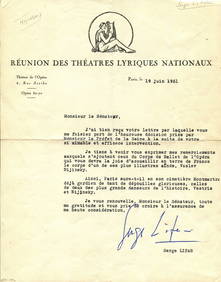
LIFAR SERGE: (1905-1986) On Nijinsky's body being reinterred at Montmartre CemeteryInternational Autograph Auctions Europe S.L.4.5(52)See Sold PriceMar 13, 2024
NICOLAS LEMERY'S 1717 PHARMACOPEIA IS AN OLD FRENCH PHARMACOLOGY TREATISE FROM THE 17TH CENTURY.NY Elizabeth 4.3(84)See Sold PriceMar 03, 2024
HUGO VICTOR: (1802-1885)International Autograph Auctions Europe S.L.4.5(52)See Sold PriceMar 14, 2024
VERNE JULES: (1828-1905)International Autograph Auctions Europe S.L.4.5(52)See Sold PriceMar 14, 2024
ELISABETH OF VALOIS: (1545-1568)International Autograph Auctions Europe S.L.4.5(52)See Sold PriceMar 14, 2024


![Railways & Transport.- [Prospectus] The Dorking, Brighton, and Arundel Atmospheric Railway, by (1 of 1)](https://p1.liveauctioneers.com/5458/319736/171654703_1_x.jpg?height=282&quality=70&version=1708010439)