SoldTwo Early Maps, One Each By Blaeu and HomannTwo Early Maps, One Each By Blaeu and Homann both hand-colored engravings, the first "Dioecese de Rheims, et le pais de Rethel" by Willem and Joan Blaeu, Amsterdam, circa 1650, depicts Rheims and surrSee Sold Price
Sold2 Old Map Prints Africa, Monomotapa -FrenchThese are two early French made African maps. One shows the entire continent. The image size is 8 x 11 inches. The other shows the Rothschild family house in Frankfurt. The image size is 7 x 9 inches,See Sold Price
SoldMid-19th C Hunting Maps Royal HuntTWO folding early 19th century hunting maps: one for the Royal Hunt and the other for the Albrighton Hunt. Fine condition, each approx. 8 x 13”. Please note that this lot has a confidential reserve.See Sold Price
Sold1690's North and South America Map California as ITwo Beautiful 17th Century map of North America and South America. Each about 8 x 6", Dated 1690, two truly historic beautifully detailed very early maps. One is titled "L'AMERIQUE Septentrionale." inSee Sold Price
Sold1690's North and South America Map of CaliforniaSubtitle: Description:Two Beautiful 17th Century map of North America and South America. Each about 8 x 6", Dated 1690, two truly historic beautifully detailed very early maps. One is titled "L'AMERIQSee Sold Price
Sold1690's North and South America Map California asTwo Beautiful 17th Century map of North America and South America. Each about 8 x 6", Dated 1690, two truly historic beautifully detailed very early maps. One is titled "L'AMERIQUE Septentrionale." inSee Sold Price
SoldTwo Early Hand Colored Framed MapsTwo early hand colored maps, 18th century by Georgius Hoefnagle, comprising "Velitrae Vulgo Blitri" and "Pisaurum Vulgo Pezaro", both framed, not examined out of frames. Map one sight: 11 1/4" high, 1See Sold Price
SoldTwo Early Maps"J. Churchill Dacuerrean Artist Delhi" (one) states "1856 Delaware Co. Map of New York from actual Survey by Jay Gould Published by Collins G. Keeney No 17 & 19 Minor St. Philadelphia." Paper on canvaSee Sold Price
SoldTwo Early Maps 1662, 1754Two Early Maps, Map of Asia, c.1662, Family of Willem Janszoon Blaeu, Dutch, ht. 20 1/2, wd. 23 1/4 & Nieuwe Kaart Van het Weftelykste Deel der Weereld, 1734 by IS. Tirion, ht. 15 3/4, wd. 18 1/2See Sold Price
SoldTwo Early Maps - CAc1860 This is a pair of framed and matted maps, one of the western United States dated 1860 and the other, a full map of the United Staes, dated 1865. Both are in good condition, with the western mapSee Sold Price
SoldTWO EARLY EUROPEAN MAPS. Map of France by Johann BTWO EARLY EUROPEAN MAPS. Map of France by Johann Baptist Homann (Nuremburg, Germany, 1663-1724), engraving on laid paper with handcoloring, 18th Century, 23"h. 25 1/2"w. (framed); and a map of DenmarkSee Sold Price
SoldTwo and a half early 20th century linen backed mapTwo and a half early 20th century linen backed maps, one half on central and western Germany and one of Southern TurkeySee Sold Price
SoldFive linen backed maps of Germany, TO BETwo and a half early 20th century linen backed maps, one half on central and western Germany and one of Southern TurkeySee Sold Price
Sold2 British Possessions Caribbean & Atlantic Maps, 1746Two colorful, early maps of British possessions in the Caribbean and the Atlantic on one sheet from le Rouge's Introduction a La Geographie. The upper map depicts Jamaica divided into parishes, with aSee Sold Price
TWO FRAMED MAPS. One is an early engraviTWO FRAMED MAPS. One is an early engraving with handcoloring of the eastern U. S. including Pennsylvania, Kentucky, and the "Western Territory". Also the "River St. Laurence" by J. & G. Menzies. Edin.See Sold Price
Sold4 Framed PrintsLot of four framed prints, to include: two hand colored Hans Holbein portraits of royalty, one early map of America, and one etching of Pont Neuf, Paris, signed Louis Orr and editioned 60/100. ProvenaSee Sold Price
SoldTwo Early Framed Hand Colored Mapscomprising Johann Baptist Homann (German, 1664-1724), "Nova Anglia" and a smaller unsigned map, "Dania Regnum." Not examined out of frames. Stains, toning. Largest: 27 1/2" high, 30 1/2" wide. ProvenaSee Sold Price
SoldTwo early 19th Century folding maps of Essex withTwo early 19th Century folding maps of Essex with coloured decoration, published by William Darton and Sons, London, one with a cloth sliding caseSee Sold Price
SoldTwo 17th Century Maps, Spain and MoroccoTwo framed, two page, hand colored, engraved maps, one is from an atlas by Willem and Joan Blaeu, titled "Legionis Regnum et Asturiarum Principatus", the other is from an atlas by Jan Jansson, drawn bSee Sold Price
Two 17th Century Maps, Spain and MoroccoTwo framed, two page, hand colored, engraved maps, one is from an atlas by Willem and Joan Blaeu, titled "Legionis Regnum et Asturiarum Principatus", the other is from an atlas by Jan Jansson, drawn bSee Sold Price
Two Vintage Maps of Early AmericaLate 20th century, printed on Arches paper. Two colorful maps of early America fitted within teal frames. Overall good condition; one print has toning in bottom margin.See Sold Price
SoldAmerican Oak Print/Map Cabinet,American Oak Print/Map Cabinet, early 20th century, in two parts, one resting atop the other, each with four wide shallow drawers on a plinth base, h. 36", w. 48-3/4", d. 35-1/2".See Sold Price
SoldRARE EARLY MAP OF AMERICAS WITH LATER NOTATION -RARE EARLY MAP OF AMERICAS WITH LATER NOTATION - "Americae, nova Tabula" by Willem Janszoon Blaeu, Amsterdam, circa 1650, hand colored engraving on two joined sheets, printed prior to the 1700 editionSee Sold Price
Ukraine, one of the earliest detailed maps of theTitle: Ukraine, one of the earliest detailed maps of the country. 1762 by Homann Heirs Date/Period: 1762 Materials: Copperplate engraved Size: 24 x 20 1/2" The best detailed early map of the region. SSee Sold Price
Joseph Martin Kronheim Pair Early Color Glamor Prints c1850Luis Porretta Fine Arts4.3(10)See Sold PriceMar 02, 2024
An Austria Amphora glazed, ceramic, florical basket with two hanging boysOstantix Auctions4.4(11)See Sold PriceFeb 28, 2024
Early 1990s Chicago Transit Authority Fiberglass Line MapRail & Road Auctions4.6(165)See Sold PriceMar 08, 2024
[JAPANESE BASEBALL]. Group of Two Early Score Cards and One...Potter & Potter Auctions4.6(550)See Sold PriceMar 07, 2024
Willem Blaeu, Etc. 17th C. Antiquarian Maps, 2Auctions at Showplace4.6(744)See Sold PriceMar 17, 2024
TWO EARLY 19TH CENTURY CHAMBERLAINS WORCESTER SQUARE FORM DISHES one of floral design, the other witHannam's Auctioneers Ltd4.3(399)See Sold PriceFeb 27, 2024
TWO EARLY NORTH AMERICAN INUIT CARVED STONE TOGGLES OR PENDANTS one formed as a male, one formed asHannam's Auctioneers Ltd4.3(399)See Sold PriceFeb 27, 2024
[Constructivism]. The general plan of reconstruction of Moscow. - Moscow: Moscow Worker, 1936. -ARTMAXIMUM4.3(4)See Sold PriceMar 14, 2024
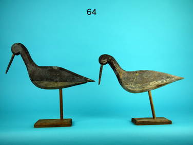
TWO EARLY SHOREBIRDS, SOUTH JERSEYFrank and Frank Sporting Collectibles LLC4.7(174)See Sold PriceMar 10, 2024


![[JAPANESE BASEBALL]. Group of Two Early Score Cards and One... (1 of 3)](https://p1.liveauctioneers.com/928/318880/171361461_1_x.jpg?height=282&quality=70&version=1707501302)


![[Constructivism]. The general plan of reconstruction of Moscow. - Moscow: Moscow Worker, 1936. - (1 of 6)](https://p1.liveauctioneers.com/6171/320219/172084257_1_x.jpg?height=282&quality=70&version=1708525949)