ATLAS of ANTIENT GEOGRAPHY by SAMUEL BUTLER 1843John McInnis Auctioneers,LLC4.6(502)See Sold PriceFeb 24, 2024
18TH C. ANTIQUE MAP: FRENCH & INDIAN WAR, FRAMEDThomaston Place Auction Galleries4.4(386)See Sold PriceFeb 24, 2024
Rand McNally Railroad Map Cabinet w/ 21 Railroad MapsRail & Road Auctions4.6(165)See Sold PriceMar 08, 2024
Keith Haring - Ink on New York Map, Best Buddies, Inscribed, Signed, and DatedSapphire Auction Gallery4(67)See Sold PriceMar 02, 2024
LATE 17TH C. FRENCH MAP OF THE NEW WORLD BY ALEXIS-HUBERT JAILLOT (1632-1712)Thomaston Place Auction Galleries4.4(386)See Sold PriceFeb 24, 2024
Central Railroad of New Jersey Map of Sandy Hook Route-ca. 1903JM Hobby Supply and Railroad Artifact Auctions4.4(126)See Sold PriceFeb 24, 2024
Lot of Six Mixed Atlas Box Cars-HO Scale-New in BoxJM Hobby Supply and Railroad Artifact Auctions4.4(126)See Sold PriceFeb 25, 2024
Rand McNally/Santa Fe Railroad Map of Iowa-1912JM Hobby Supply and Railroad Artifact Auctions4.4(126)See Sold PriceFeb 24, 2024
NICOLAES VISSCHER (NETHERLANDS, 1618-1709) MAP OF THE NEW WORLDThomaston Place Auction Galleries4.4(386)See Sold PriceFeb 24, 2024
17TH C. WORLD MAP BY NICOLAES VISSCHER (NETHERLANDS, 1618-1709)Thomaston Place Auction Galleries4.4(386)See Sold PriceFeb 24, 2024
Lot of Six Mixed Atlas Cabooses-HO Scale-New in BoxJM Hobby Supply and Railroad Artifact Auctions4.4(126)See Sold PriceFeb 25, 2024
SoldRobinson Map of PalestineRobinson, Edward. (1794-1863), Smith, Eli (1801-1857), & Kiepert, Heinrich (1818-1899). A New Map of Palestine... Engraved map. J. H. Colton & Co, 1845. 40" x 28" sheet. "...From the Latest AuthoritieSee Sold Price
SoldMAPS OF ROBINSON'S RESEARCHES IN PALESTINE, 4 MAPS,MAPS OF ROBINSON'S RESEARCHES IN PALESTINE, 4 MAPS, SOME TEARS, SEPARATED FROM BOOK. CIRCA 1856.See Sold Price
SoldMAPS OF ROBINSON'S RESEARCHES IN PALESTINE, 4 MAPS,MAPS OF ROBINSON'S RESEARCHES IN PALESTINE, 4 MAPS, SOME TEARS, SEPARATED FROM BOOK. CIRCA 1856.See Sold Price
SoldMap of Palestine With the Hauran, 1852Map: Palestine With the Hauran and the Adjacent Districts Maker: Charles Knight/george Cox/SDUK, Walker, J. & C./W. Hughes/Robinson/Burckhardt/Jacotin Publication Date: 1852 Publisher: Charles Knight/See Sold Price
SoldJ.H. Colton/ Publisher 1856J.H. Colton/ Publisher, "New Map of Palestine, from the Latest Authorities, Chiefly from the Maps & Drawings of Robinson & Smith with Corrections and Additions Furnished by the Revd. Dr. Robinson", NeSee Sold Price
SoldRobinson(E Biblical Researches in PalestineRobinson (Edward) Biblical Researches in Palestine, Mount Sinai and Arabia Petræa,4 vol., 6 folding maps, 3 hand-coloured in outline, 1 with tear along fold, illustrations, occasional water-stSee Sold Price
SoldGuthrie/Dilly & Robinson: Map of West Indies, 1785Map: The West Indies According to the best Authorities. Cartographer: William Guthrie / Dilly & Robinson Place & Date: London / 1785 Size: 20 1/2" x 11" The West Indies map from Guthrie's New System oSee Sold Price
SoldANTIQUE MAP "PALESTINE"By Johnson and Ward. With hand coloring. Dimensions: (Frame) H 21.5" x W 17", (Sight) H 16" x W 12.75" Condition: Toning. Handling wear including rubs to frame.See Sold Price
SoldD.F.R. Robinson Map of the United States.D.F.R. Robinson Map of the United States. Connecticut, 1828. Engraved map in two colors. Framed and matted, 19 x 24" overall. Mild brownish discoloration along central vertical fold, otherwise fine.See Sold Price
SoldToms & Cellarius 1789 Map. Palestine, Israel"Palaestina sev Terra Sancta" Copper Engraved Map Published 1789, London for "Geographia Antiqua" Engraved W. H. Toms after an earlier map by Christoph Cellarius. Centre fold as published. Paper Size:See Sold Price
Sold1887 Hand Colored Map Palestine & Environs of Jerusalem1887 Hand Colored Engraving "Map of Palestine" with an inset of the "Environs of Jerusalem"Signed in plate: Bradley 1887Size: Approximately 8 1/4" x 11 1/4"Condition: A fSee Sold Price
SoldRobinson Map of MexicoROBINSON, John Hamilton (1782 - 1819). A Map of Mexico, Louisiana and the Missouri Territory... Engraved map with contemporary outline handcoloring and light varnishing ( Engraved by H. Anderson). WasSee Sold Price
SoldPropaganda Poster URNA Map Palestine RefugeesOriginal vintage Map of URNA Areas of Operation - The Gaza Strip - Lebanon. Created in December 1949, the United Nations Relief and Works Agency for Palestine Refugees in the Near East (UNRWA) is a reSee Sold Price
Soldmap, Palestine, MaginiFramed hand colored engraved map of Palestine, ''Palaestina, Vel Terra Sancta,'' 18th century, after Giovanni Antonio Magini (Italian, 1555-1617), sight: 5.75''h x 7.25''w, overall: 15''h x 13''wSee Sold Price
SoldPropaganda Poster URNA Map Palestine RefugeesOriginal vintage Map of URNA Areas of Operation - The Gaza Strip - Lebanon. Created in December 1949, the United Nations Relief and Works Agency for Palestine Refugees in the Near East (UNRWA) is a reSee Sold Price
SoldBrass Curved Hip Flask with Palestine Map, Palestine,Brass Curved Hip Flask with Palestine Map, Palestine, Early 20th Century.Engraved with the map of Palestine including the location of cities as Haifa, Tel-Aviv, Jaffa, Jerusalem, Nazareth, and Beth LeSee Sold Price
SoldBooks and a Set of Maps - Palestine Exploration Fund -1. Map of Western Palestine in 26 sheets from surveys conducted for the committee of the Palestine Exploration Fund by Lieuts. C. R. Conder and H. H. Kitchener, R. E. during the Years 1872-1877. PrintSee Sold Price
Bartholomew Map PalestineTopographical and Physical Map of Palestine by J G Bartholomew edited by George Adam Smith 1901 Measures 96 x 115 cms . Very attractive colour linen backed map in a cloth bound folder with an explanatSee Sold Price
1844 Robinson Map of the British Isles -- Map of theTitle/Content of Map: 1844 Robinson Map of the British Isles -- Map of the British Isles Date: 1844, Hartford Cartographer: D Robinson Size: 10.4 X 8.5 in. This is nice map of the British Isles. PlentSee Sold Price
Map. Palestine. 1829.Print from steel engraving titled „IV. Palestina“.From Schul-Atlas der alten Welt. Published by Gotha Perthes. 1829.Orbis Terrarum Antiquus. School Atlas of the Ancient World edited by D'Anville,See Sold Price
Sold3 Old Maps - Palestine, the Beginning of the 20th3 Old Maps - Palestine, the Beginning of the 20th Century The maps were printed in Great Britain and the USA (Edinburgh, New Jersey) by the following companies:Geographia Map Company - Alexander GrossSee Sold Price
Four Maps - "Palestine Exploration Fund" - Lon...Palestine Exploration Fund map, from surveys conducted for the committee of the Palestine Exploration Fund by C. R. Conder and H.H. Kitchener, Stanford's Geographical Establishment. Four maps of PalesSee Sold Price
1844 Robinson Map of the British Isles -- Map of theTitle/Content of Map: 1844 Robinson Map of the British Isles -- Map of the British Isles Date: 1844, Hartford Cartographer: D RobinsonSize: 10.4 X 8.5 in. This is nice map of the British Isles. PlentySee Sold Price
SoldRobinson MAPS OF LOS ANGELES Gold Rush Ltd. Ed."Title: Maps of Los Angeles Author: W.W.Robinson Publisher: Dawson's Printing Year: 1966 Condition/Details: Bound in gray cloth with paper spine title on red background and a prited medaSee Sold Price
Replica Robinson 1862 Sharps CarbineSchmidt's Antiques Inc. Since 19114.8(431)See Sold PriceMar 02, 2024
18TH C. ANTIQUE MAP: FRENCH & INDIAN WAR, FRAMEDThomaston Place Auction Galleries4.4(386)See Sold PriceFeb 24, 2024
Jerusalem Map for British Soldiers in Palestine - WW2Levy Auction House4.3(11)See Sold PriceFeb 27, 2024
Proposed Sportsground Map - Haifa, Palestine - 1926Levy Auction House4.3(11)See Sold PriceFeb 27, 2024
Caravan Routes in Palestine Linen Map - Germany, 1881Levy Auction House4.3(11)See Sold PriceFeb 27, 2024
The Holy Land Tours - Hamburg American Line - 1911Levy Auction House4.3(11)See Sold PriceFeb 27, 2024
18 Booklets Collection - War Graves of Palestine - WWILevy Auction House4.3(11)See Sold PriceFeb 27, 2024
Illustrated Sabbath Cloth - Holy Sites of Eretz IsraelLevy Auction House4.3(11)See Sold PriceFeb 27, 2024
Keith Haring - Ink on New York Map, Best Buddies, Inscribed, Signed, and DatedSapphire Auction Gallery4(67)See Sold PriceMar 02, 2024
Rand McNally Railroad Map Cabinet w/ 21 Railroad MapsRail & Road Auctions4.6(165)See Sold PriceMar 08, 2024
Putnam - First Map of the State of Ohio by Rufus PutnamTrillium Antique Prints & Rare Books4.5(30)See Sold PriceFeb 24, 2024
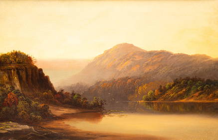
POSSIBLY SANFORD ROBINSON GIFFORD (1823-1880) "LANDSCAPE".Amelia Jeffers, Auctioneers & Appraisers4.6(101)See Sold PriceMar 07, 2024
1760 MAP CARTE PARTICULIERE DE L'ISLE DE JUAN FERNANDES antique Robinson CrusoeJasper524.5(9.8k)See Sold PriceFeb 27, 2024