ATLAS of ANTIENT GEOGRAPHY by SAMUEL BUTLER 1843John McInnis Auctioneers,LLC4.6(502)See Sold PriceFeb 24, 2024
18TH C. ANTIQUE MAP: FRENCH & INDIAN WAR, FRAMEDThomaston Place Auction Galleries4.4(386)See Sold PriceFeb 24, 2024
Rand McNally Railroad Map Cabinet w/ 21 Railroad MapsRail & Road Auctions4.6(165)See Sold PriceMar 08, 2024
Keith Haring - Ink on New York Map, Best Buddies, Inscribed, Signed, and DatedSapphire Auction Gallery4(67)See Sold PriceMar 02, 2024
LATE 17TH C. FRENCH MAP OF THE NEW WORLD BY ALEXIS-HUBERT JAILLOT (1632-1712)Thomaston Place Auction Galleries4.4(386)See Sold PriceFeb 24, 2024
Central Railroad of New Jersey Map of Sandy Hook Route-ca. 1903JM Hobby Supply and Railroad Artifact Auctions4.4(126)See Sold PriceFeb 24, 2024
Lot of Six Mixed Atlas Box Cars-HO Scale-New in BoxJM Hobby Supply and Railroad Artifact Auctions4.4(126)See Sold PriceFeb 25, 2024
Rand McNally/Santa Fe Railroad Map of Iowa-1912JM Hobby Supply and Railroad Artifact Auctions4.4(126)See Sold PriceFeb 24, 2024
NICOLAES VISSCHER (NETHERLANDS, 1618-1709) MAP OF THE NEW WORLDThomaston Place Auction Galleries4.4(386)See Sold PriceFeb 24, 2024
17TH C. WORLD MAP BY NICOLAES VISSCHER (NETHERLANDS, 1618-1709)Thomaston Place Auction Galleries4.4(386)See Sold PriceFeb 24, 2024
Lot of Six Mixed Atlas Cabooses-HO Scale-New in BoxJM Hobby Supply and Railroad Artifact Auctions4.4(126)See Sold PriceFeb 25, 2024
Sold* MELISH, John (1771-1822). Map of the United* MELISH, John (1771-1822). Map of the United States...Entered...the 16th day of June, 1820... Philadelphia, 1820. Engraved folding map by J. Vallance and H.S. Tanner, overall 915 x 1490 mm, hand-coloSee Sold Price
Melsih Map of the United States, 1823*** START PRICE IS THE RESERVE *** [America] MELISH, John (1771-1822). Map of the United States with the Contiguous British and Spanish Possessions. Engraved map with original color on 50 segements anSee Sold Price
Sold* MELISH, John. Map of the United States with the* MELISH, John (1771-1822). Map of the United States with the contiguous British & Spanish Possessions. Philadelphia: John Melish, 1816. Engraved folding map by J. Vallance and H.S. Tanner, overall 90See Sold Price
SoldMelish Map of the United States 1823MELISH, John (1771-1822). Map of the United States with the Contiguous British and Spanish Possessions. Philadelphia: James Finlayson successor to John Melish, 1823. Folding engraved map (45 x 57 4/8See Sold Price
Sold* MELISH, John (1771-1822). Map of the United* MELISH, John (1771-1822). Map of the United States....Entered...the 6th day of June, 1816...Improved to the 1st of January, 1818. Philadelphia, 1818. Engraved folding map by J. Vallance and H.S. TanSee Sold Price
SoldJOHN MELISH (SCOTTISH-AMERICAN, 1771-1822) MAP OF THEJOHN MELISH (SCOTTISH-AMERICAN, 1771-1822) MAP OF THE UNITED STATES, hand-colored engraving on paper, engraved by Benjamin Tanner (American, 1775-1848), from Carey & Lea's "A Complete Historical, ChroSee Sold Price
SoldMELISH, John (1771-1822). United States of America. PhiMELISH, John (1771-1822). United States of America. Philadelphia, 1818. Engraved map of the United States, contemporary hand-coloring in outline, visible area 16 1/4 x 19 1/2 in. (419 x 493 mm), matteSee Sold Price
SoldJOHN MELISH (SCOTLAND/AMERICAN 1771-1822), EARLY ANDJOHN MELISH (SCOTLAND/AMERICAN 1771-1822), EARLY AND RARE MAP OF THE UNITED STATES OF AMERICA, C.1813. ENTERED AS THE ACT DIRECTS AND PUBLISHED BY JOHN MELISH, PHILADELPHIA, JUNE 1813. SIGHT 13 X 17 1See Sold Price
Map of the United States ...John Melish (1771-1822). Engraved map in 40 sections dissected and mounted on original linen with original hand color in outline. Philadelphia: John Melish, 1816. 35 1/2 x 58 1/4 inches framed. The MoSee Sold Price
SoldJohn Melish (Scottish/American, 1771-1822)John Melish (Scottish/American, 1771-1822), "A Map of the Southern Section of the United States including the Floridas and Bahama Islands Shewing the Seat of War, in that Department", drawn by John MeSee Sold Price
SoldMap of the United States with the contiguous British &Map of the United States with the contiguous British & Spanish Possessions Compiled from the latest & best authorities. Philadelphia John Melish (Scottish/American 1771-1822) First Edition, 5th StateSee Sold Price
SoldJohn Melish (1771-1822) American. "Northern Section ofJohn Melish (1771-1822) American. "Northern Section of the United States, Including Canada', Map, Unframed, 14.5" x 20", together with another nine maps, by various hands, ten (10).See Sold Price
SoldAfter John Melish (1771-1822) American. "NorthernAfter John Melish (1771-1822) American. "Northern Section of the United States, Including Canada', Map, Unframed, 14.5" x 20", together with another nine maps, by various hands, ten (10).See Sold Price
Sold* MELISH, John (1771-1822). A Geographical Description* MELISH, John (1771-1822). A Geographical Description of the United States, with the Contiguous Countries, including Mexico and the West Indies. Philadelphia: by the Author, 1822. 8vo (213 x 133 mm).See Sold Price
SoldMap of New Orleans and Adjacent Country"Map of New Orleans and Adjacent Country" by John Melish (Scottish/American, 1771-1822), hand-colored engraved map from A Military and Topographical Atlas of the United States, published Philadelphia,See Sold Price
SoldMELISH. Wall Map of Pennsylvania. 1826MELISH, John (1771-1822) Map of Pennsylvania Constructed from the County Surveys authorized by the State; and other original Documents?Corrected and Improved to 1826. Engraved by Benjamin TaSee Sold Price
SoldMelish 1812 War MapMELISH, John (1771-1822). Map of the Seat of War in North America. Engraved Map with original hand color in outline. Philadelphia, 1813. 19 1/2" x 23 3/4" sheet. Regional Map of Melish's Famed MilitarSee Sold Price
SoldJohn Melish (Scottish/American, 1771-1822)John Melish (Scottish/American, 1771-1822), "Map of the Seat of War among the Creek Indians From the Original Drawings in the War Department", Philadelphia, John Melish, 1814, engraved map, hand-colorSee Sold Price
SoldJohn Melish (Scottish/American)John Melish (Scottish/American, 1771-1822), "Map of New Orleans and Adjacent Country", Philadelphia, John Melish, 1815, hand-colored engraved map, with folds, as issued, from A Military and TopographiSee Sold Price
SoldJerusalem Map, 1798.Jerusalem Map, 1798. Wilkinson Robert Atlas. John Melish, 1771-1822. Title: The Land of Moriah or Jerusalem and the Adjacent Country. 28x22cm. Minor flaws.See Sold Price
SoldA Geographical Description of the World[..Intended as an Accompaniment to the Map of the World on Mercator's Projection], by John Melish, (Scottish, 1771-1822), Philadelphia: published John Melish, 1818, with three folding maps (complete),See Sold Price
SoldMap of the United States of America, John Melish,Philadelphia, H. C. Corey & I. Lea, 1822, engraved by Benjamin Tanner, had colored from a complete historical, chronological and geographical American atlas. Sight size 17" x 22", in a high quality moSee Sold Price
United States of America.Title: United States of America. Publication Date:1822 ca. Cartographer: Publisher: J. Warr Jr. Brief Description: Engraved by J. Warr Jr. No 110 Walnut St. Philada. in the style of John Melish with cSee Sold Price
SoldMELISH, JOHN. Map of the United States with thMELISH, JOHN. Map of the United States with the Contiguous British & Spanish Possessions. Large engraved map, dissected in 40 sections and linen-backed, 895x1425 mm overall; hand-colored; new linen baSee Sold Price
Edward John Cobbett (UK,1815-1899) oil painting antiqueBroward Auction Gallery4.8(277)See Sold PriceMar 10, 2024
John Muirhead (UK,1863-1927) watercolor painting antiqueBroward Auction Gallery4.8(277)See Sold PriceMar 10, 2024
American Express/New York Central Railroad Map of the United States-1934JM Hobby Supply and Railroad Artifact Auctions4.4(126)See Sold PriceFeb 24, 2024
John Henry Dell (UK,1836-1888) oil painting antiqueBroward Auction Gallery4.8(277)See Sold PriceMar 17, 2024
John Lynas Gray (UK,1869-1933) watercolor painting antiqueBroward Auction Gallery4.8(277)See Sold PriceMar 17, 2024
17TH C. MAP OF THE BERKSHIRES BY JOHN SPEED, FRAMEDThomaston Place Auction Galleries4.4(386)See Sold PriceFeb 24, 2024
JOHN WARD OF HULL (United Kingdom, 1798-1849), "A Frigate Offshore"., Oil on canvas, 19.5" x 28".Eldred's4.7(409)See Sold PriceFeb 28, 2024
1952 MAY, J.F.K. HANDWRITTEN LETTER & ENVELOPEJohn McInnis Auctioneers,LLC4.6(502)See Sold PriceFeb 25, 2024
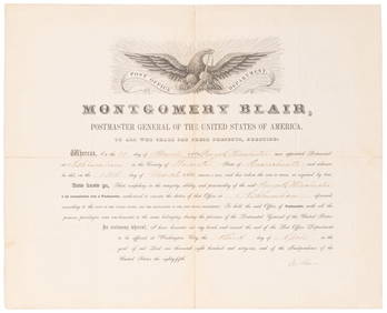
SOMERSET, Lord Charles (1767-1831) and BLAIR, Montgomery (1...Potter & Potter Auctions4.6(539)See Sold PriceMar 07, 2024
John Harris (UK,1791-1879) oil painting antiqueBroward Auction Gallery4.8(277)See Sold PriceMay 05, 2024
1822 MAP of NORTH & SOUTH AMERICA GEOGRAPHICAL STATISTICAL HISTORICAL antiqueJasper524.5(9.8k)See Sold PriceFeb 27, 2024
John Senex Map of Louisiana & Mississippi RiverWillow Auction House4.5(283)See Sold PriceMar 14, 2024