SoldVINTAGE ORANGE/ROCKLAND COUNTY MAP, 1859VINTAGE ORANGE/ROCKLAND COUNTY MAP, 1859, PUBLISHED BY COREY AND BACHMANSee Sold Price
SoldORANGE & ROCKLAND COUNTY'S MAP, 1859ORANGE & ROCKLAND COUNTY'S MAP, 1859 H. 65" W. 62 1/2"See Sold Price
SoldORANGE & ROCKLAND COUNTIES MAP, BEERS 1859ORANGE & ROCKLAND COUNTIES MAP, BEERS 1859 64" X 63"See Sold Price
SoldORANGE & ROCKLAND COUNTIES MAP, BEERS 1859ORANGE & ROCKLAND COUNTIES MAP, BEERS 1859 64" X 63"See Sold Price
SoldORANGE & ROCKLAND COUNTIES MAP, BEERS 1859ORANGE & ROCKLAND COUNTIES MAP, BEERS 1859 64" X 63"See Sold Price
SoldORANGE & ROCKLAND COUNTY NEW YORK MAP, BEERSORANGE & ROCKLAND COUNTY NEW YORK MAP, BEERS 1859 64" X 63"See Sold Price
SoldFRENCH, WOOD, AND BEERS MAP OF ORANGE & ROCKLANDFRENCH, WOOD, AND BEERS MAP OF ORANGE & ROCKLAND COUNTIES, 1859See Sold Price
SoldFRENCH, WOOD, AND BEERS MAP OF ORANGE & ROCKLANDFRENCH, WOOD, AND BEERS MAP OF ORANGE & ROCKLAND COUNTIES, 1859See Sold Price
SoldFRENCH, WOOD, AND BEERS MAP OF ORANGE & ROCKLANDFRENCH, WOOD, AND BEERS MAP OF ORANGE & ROCKLAND COUNTIES, 1859See Sold Price
SoldVINTAGE BUCK'S COUNTY PENNSYLVANIA MAP. FRAMED ANDVINTAGE BUCK'S COUNTY PENNSYLVANIA MAP. FRAMED AND GLAZED-31 X 35"See Sold Price
Sold2 Vintage Town and County MapsIncludes Newburg and Hopewell. 15” wide x 19-1/4” highSee Sold Price
SoldORANGE & ROCKLAND COUNTIES NY MAPORANGE & ROCKLAND COUNTIES NY MAP, DAVID H. BURR, 1829, FRAMED 31" X 22 1/2"See Sold Price
SoldORANGE & ROCKLAND COUNTIES NY MAP 1839, FRAMEDORANGE & ROCKLAND COUNTIES NY MAP 1839, FRAMED 30" X 24"See Sold Price
21: 1859 MAP, ORANGE COUNTY1859 MAP, ORANGE COUNTY. 66 X 62 1/2 (AS IS) **DUE TO THE SIZE AND/OR FRAGILITY OF THIS LOT, STANDARD IN-HOUSE SHIPPING IS NOT AVAILABLE. PLEASE CONTACT THE GALLERY FOR A LIST OF TRUCKERS**See Sold Price
SoldGeddie (John) Illustrations of the scenery of theGeddie (John) Illustrations of the scenery of the river Tay, plates, Edinburgh, 1891 Philip (G.) Tourist's companion to the counties of Scotland, coloured maps, 1859, original cloth, soiledSee Sold Price
SoldAntique 1859 Map of Kendall County IllinoisBy L. J. Bennett, 45 x 51 inches some damageSee Sold Price
SoldAntique 1859 Map of Kendall County IllinoisBy L. J. Bennett, 45 x 51 inches some damageSee Sold Price
Vintage Map SUFFOLK COUNTY LONG ISLAND, 1858Description: Antique map of Suffolk County, Long Island, 1858 Whitlock's, New Haven, CT. Including tables of statistics and distances. 18" width. all measurements are approximate; Shipping cost: $25.See Sold Price
SoldWALL MAP ORANGE & ROCKLAND CO., 1859WALL MAP ORANGE & ROCKLAND CO., 1859. 66 X 63" (CREASES, STAINS, MINOR LOSSES)See Sold Price
SoldMAP - ORANGE & ROCKLAND COUNTIES, GURR,ENGRAVED MAP - ORANGE & ROCKLAND COUNTIES, DAVID H. GURR, ITHACA 1840, PLATE 17 20 1/2" (FRAMED & GLAZED)See Sold Price
Sold1839 D. Burr Map Orange & Rockland Counties NYDESCRIPTION: Colored map of Orange and Rockland counties, New York. Drawing by David W. Burr and published by Stone and Clark under the direction of the surveyor general of New York. Dated 1839. PROVESee Sold Price
Sold1859 WALL MAP OF BELKNAP COUNTY NEW HAMPSHIREPublished by Smith and Peavey Philadelphia. colored lithograph backed by cloth and mounted to hangers 54 x 54See Sold Price
Sold1859 WALL MAP OF BELKNAP COUNTY NEW HAMPSHIREPublished by Smith and Peavey Philadelphia. colored lithograph backed by cloth and mounted to hangers 54 x 54.See Sold Price
Vintage County Map Of NY State Plate EngravingThe Benefit Shop Foundation Inc.4.3(2.9k)See Sold PriceFeb 28, 2024
Portfolio of 15 County Maps by Robert Morden (English 1650-1703)Nadeau's Auction Gallery4.7(398)See Sold PriceFeb 24, 2024
Rand McNally & Co's New Ideal State and County Survey and Atlas 1911North American Artifact Auctions4.7(175)See Sold PriceApr 20, 2024
VARIOUS ARTISTS [BRITISH TRAVEL GUIDES]. Group of 6 map booklets and flyers. 1930s.Swann Auction Galleries4.4(64)See Sold PriceFeb 29, 2024
3 Vintage The World Lithographs, By JanssonThe Benefit Shop Foundation Inc.4.3(2.9k)See Sold PriceMar 13, 2024
West Africa by Arrowsmith & Lewis 1812 old antique vintage map plan chartJasper524.5(9.7k)See Sold PriceFeb 28, 2024
Western Sahara. Africa 1885 old antique vintage map plan chartJasper524.5(9.7k)See Sold PriceFeb 28, 2024
AFRICA. Africa. Britannica 9th edition 1898 old antique vintage map plan chartJasper524.5(9.7k)See Sold PriceFeb 28, 2024
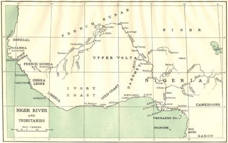
AFRICA. Niger River and Tributaries 1936 old vintage map plan chartJasper524.5(9.7k)See Sold PriceFeb 28, 2024
Showers of Red Dust. Africa. Sahara 1886 old antique vintage map plan chartJasper524.5(9.7k)See Sold PriceFeb 28, 2024
Africa by Arrowsmith & Lewis 1812 old antique vintage map plan chartJasper524.5(9.7k)See Sold PriceFeb 28, 2024
Vintage Map of Roman Forum - Vatican City - Versailles parkProverde Auctions4.3(3)See Sold PriceFeb 28, 2024
Vintage Map - På Vakts Krigskarta över Norden / On Vakt's war map of the Nordic region, SecondProverde Auctions4.3(3)See Sold PriceFeb 28, 2024
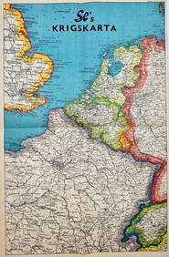
Vintage Map - Krigskarta - War Map - Second World War, published 1940Proverde Auctions4.3(3)See Sold PriceFeb 28, 2024
California Vintage Maps & Brochures (44 Pcs)Grant Zahajko Auctions, LLC4.8(1k)See Sold PriceMar 06, 2024
Colorado Vintage Maps & Travel Brochures (76 Pcs)Grant Zahajko Auctions, LLC4.8(1k)See Sold PriceMar 06, 2024
Framed Vintage Map Of Le Port Au Prince In The Island Of Santo DomingoRapid Estate Liquidators and Auction Gallery4.5(1.1k)See Sold PriceMar 01, 2024


![VARIOUS ARTISTS [BRITISH TRAVEL GUIDES]. Group of 6 map booklets and flyers. 1930s. (1 of 2)](https://p1.liveauctioneers.com/199/319703/171640571_1_x.jpg?height=282&quality=70&version=1707943705)