Marc Chagall-Limited Edition -Paris Opera Ceiling after ChagallArt Legacy Auctions4.5(215)See Sold PriceFeb 24, 2024
Salvador Dali Pantagruel Limited Edition Lithograph Hand signed and numberedArt Legacy Auctions4.5(215)See Sold PriceFeb 24, 2024
Pablo Picasso Bouquet of Peace Collection Domaine Picasso Limited Edition on paper.Art Legacy Auctions4.5(215)See Sold PriceFeb 24, 2024
A RARE MAXFIELD PARRISH JACK AND THE BEANSTALK PRINTSoulis Auctions4.8(945)See Sold PriceFeb 24, 2024
LARGE MECHANICAL PRINT 'STARS' AFTER MAXFIELD PARRISHSoulis Auctions4.8(945)See Sold PriceFeb 24, 2024
Heinrich Aldegrever, etc. 15 old master prints. 16th-17th centuries. Aldegrever works include "ManTremont Auctions4.6(292)See Sold PriceFeb 25, 2024
Sold1859 WALL MAP OF BELKNAP COUNTY NEW HAMPSHIREPublished by Smith and Peavey Philadelphia. colored lithograph backed by cloth and mounted to hangers 54 x 54See Sold Price
Sold1859 WALL MAP OF BELKNAP COUNTY NEW HAMPSHIREPublished by Smith and Peavey Philadelphia. colored lithograph backed by cloth and mounted to hangers 54 x 54.See Sold Price
1857 Map of ROCKINGHAM CO. NEW HAMPSHIRE:1857 Map of ROCKINGHAM CO. NEW HAMPSHIRE: Antique Hanging Wall Map of Southern New Hampshire County including Portsmouth NH. Published by Smith & Coffin 17-19 Minor St., Philadelphia. With Pictures ofSee Sold Price
SoldTopographical Map of Grafton County, New-HampshireTopographical Map of Grafton County, New-Hampshire Hand-colored Lithograph Scroll Wall Map, H.F. Walling, published by Smith, Mason & Co., New York, 1860, on linen, 60 x 61 1/2 in.See Sold Price
SoldLarge Antique Hanging Wall Map MADISON COUNTY NEW YORKDetails: This large hanging wall map of Madison County New York was published by Gillette circa 1859. It measures approx. 65" in width. Condition / Notes: This map has significant age and wear indicSee Sold Price
SoldHand-Colored WALL MAP OF CAYUGA AND SENECA COUNTIES NEWDetails: This lot consists of the antique wall map shown in the corresponding images.This map of Cayuga and Seneca Counties, New York, was published by A. R. Z. Dawson in Philadelphia, 1859. It is haSee Sold Price
SoldLARGE WALL MAP ULSTER COUNTY NEW YORKLARGE WALL MAP ULSTER COUNTY NEW YORK-OLIVER TILLSON, C. 1853 44" X 54"See Sold Price
SoldWall Map Rockland County New York, 1854WALL MAP ROCKLAND COUNTY NEW YORK, 1854 Surveyed and Published by R.F.O' Connor, New York Dimension: 46.6" x 34" Condition: Good , no stains or repairs. General handling wear. Provenance: Private EstaSee Sold Price
SoldMap Cheshire County, New Hampshirepub. Smith & Morley, Phila., 1858. Dimensions: 57 1/2" x 60"See Sold Price
SoldRollup wall map of Dutchess County New York publishedRollup wall map of Dutchess County New York published by John E. Gillette, Philadelphia, 1858 - lithographed paper applied to canvas, several stains, several small holes approximately 1/2", but overalSee Sold Price
SoldWall map of Dutchess County New York by surveyor J.C.Wall map of Dutchess County New York by surveyor J.C. Sidney and published in 1850 by John E. Gillette. Some minor tears and staining but overall good condition. 40" x 58".See Sold Price
Sold1860 wall map of sussex, county - new jerseyDescription: Gm. hopkins, carlos allen, md. publishers - from the estate of richard "dick" roy Condtion: Bottom wooden support is detached - some staining and discoloration Size: 52" X 56" Consignor:See Sold Price
SoldWall map of Dutchess County New York from actualWall map of Dutchess County New York from actual surveys - John E. Gillette Phila. 1858 - 59" x 61". Poor condition with stains, losses, tears.See Sold Price
SoldAntique Wall Map 1853 TOMPKINS COUNTY NEW YORK PropertyDetails: This lot is an 1853 Map of Tompkins County with Property Ownership details and Illustrated Views.This linen backed wall map measures approx. 50 3/4 x 32 1/2. The wooden top molding is presenSee Sold Price
SoldHand-Colored GILLETTE'S WALL MAP OF MADISON COUNTY NEWDetails: This lot consists of the antique wall map shown in the corresponding images.This map, "Gillette's Map of Madison Co., New York from Actual Surveys Under the Direction of J. H. French, SyracuSee Sold Price
Sold19C J. Chase June Rockingham Co. New Hampshire MapNew Hampshire,Dated 1857 Roll down school map of Rockingham county, New Hampshire including tables of distances, business directories, close up maps, and local landmarks. Marked upper middle "PublisheSee Sold Price
Sold1885 J. W. Lewis History of Merrimack and BelknapCounties, New Hampshire, and 1897 Biographical Review of Belknap and Strafford Counties, New Hampshire, both bound in gilt leather, some spine damageSee Sold Price
6Pcs Onondaga County Oneida ANTIQUE HANGING WALL MAPSDetails: This group lot comprises six (6) large antique hanging wall maps of Onondaga County, New York, United States (4), and the world. They measure up to approx. 70" in width. Condition / Notes:See Sold Price
11Pcs Madison County Oneida ANTIQUE HANGING WALL MAPSDetails: This group lot comprises eleven (11) large antique rolling wall maps of Madison County, New York (9), Oneida, New York (1), and the United States of America (1). They measure up to approx. 7See Sold Price
Sold1857 Rockingham County, New Hampshire Map(1) Rockingham County. Surveys by J. Chace. Published by Smith & Coffin. Philadelphia 1857. Roll down school map. 4' 11"w x 4' 11"h. Paper on canvas backSee Sold Price
1890s Map of Vermont and New Hampshire -- County Map ofTitle/Content of Map: 1890s Map of Vermont and New Hampshire -- County Map of Vermont and New Hampshire Cartographer: Anonymous Year/Place: 1890 ca. Size: 21.6 X 14.8 in. This is an outstanding doubleSee Sold Price
1890s Map of Vermont and New Hampshire -- County Map ofTitle: 1890s Map of Vermont and New Hampshire -- County Map of Vermont and New Hampshire Cartographer: Anonymous Year / Place: 1890 ca. Map Dimension (in.): 21.6 X 14.8 in. This is an outstanding doubSee Sold Price
Vintage County Map Of NY State Plate EngravingThe Benefit Shop Foundation Inc.4.3(2.9k)See Sold PriceFeb 28, 2024
1849 THE NEW-ENGLAND MERCANTILE UNIONNorth American Artifact Auctions4.7(175)See Sold PriceApr 20, 2024
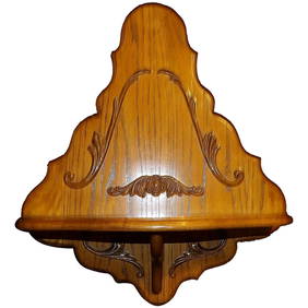
Large Pair of Neoclassical Style Murobello Wall Shelves or SconcesJasper524.5(9.7k)See Sold PriceMar 07, 2024
1950 oil painting Vermont "Beyond The Wall" Inscription On Back SnowJasper524.5(9.7k)See Sold PriceMar 07, 2024
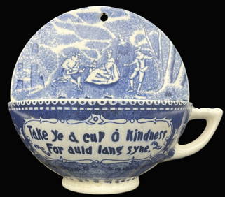
VINTAGE BLUE WHITE TRANSFERWARE HALF CUP KINDNESS AULD LANG SYNE WALL POCKETJasper524.5(9.7k)See Sold PriceMar 07, 2024
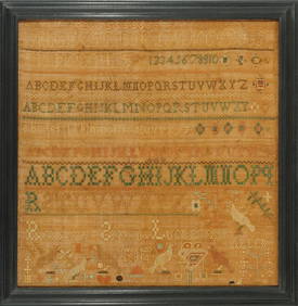
Rebecca Spohn Needlework Sampler Berks County, PA dated 1848Jasper524.5(9.7k)See Sold PriceMar 07, 2024