ATLAS of ANTIENT GEOGRAPHY by SAMUEL BUTLER 1843John McInnis Auctioneers,LLC4.5(505)See Sold PriceFeb 24, 2024
18TH C. ANTIQUE MAP: FRENCH & INDIAN WAR, FRAMEDThomaston Place Auction Galleries4.4(394)See Sold PriceFeb 24, 2024
Rand McNally Railroad Map Cabinet w/ 21 Railroad MapsRail & Road Auctions4.6(165)See Sold PriceMar 08, 2024
Keith Haring - Ink on New York Map, Best Buddies, Inscribed, Signed, and DatedSapphire Auction Gallery4.1(67)See Sold PriceMar 02, 2024
LATE 17TH C. FRENCH MAP OF THE NEW WORLD BY ALEXIS-HUBERT JAILLOT (1632-1712)Thomaston Place Auction Galleries4.4(394)See Sold PriceFeb 24, 2024
Central Railroad of New Jersey Map of Sandy Hook Route-ca. 1903JM Hobby Supply and Railroad Artifact Auctions4.4(127)See Sold PriceFeb 24, 2024
Lot of Six Mixed Atlas Box Cars-HO Scale-New in BoxJM Hobby Supply and Railroad Artifact Auctions4.4(127)See Sold PriceFeb 25, 2024
Rand McNally/Santa Fe Railroad Map of Iowa-1912JM Hobby Supply and Railroad Artifact Auctions4.4(127)See Sold PriceFeb 24, 2024
NICOLAES VISSCHER (NETHERLANDS, 1618-1709) MAP OF THE NEW WORLDThomaston Place Auction Galleries4.4(394)See Sold PriceFeb 24, 2024
17TH C. WORLD MAP BY NICOLAES VISSCHER (NETHERLANDS, 1618-1709)Thomaston Place Auction Galleries4.4(394)See Sold PriceFeb 24, 2024
Lot of Six Mixed Atlas Cabooses-HO Scale-New in BoxJM Hobby Supply and Railroad Artifact Auctions4.4(127)See Sold PriceFeb 25, 2024
Chart Showing the Track of the Flagships of The U.S.Map: Chart Showing the Track of the Flagships of The U.S. Japan Expedition Date: 1856 Cartographer: SELZ, EDWARD ? Publisher: NAVY DEPARTMENT Size (inches): 10.25X36.3 "to the Eastd. of the Cape of GoSee Sold Price
Chart: Track of Flagships of The U.S. Japan ExpeditionTitle/Content of Map: Chart Showing the Track of the Flagships of The U.S. Japan Expedition Cartographer: SELZ, EDWARD ? Size: 10.25X36.3 "to the Eastd. of the Cape of Good Hope 1853 & 1854" Outline mSee Sold Price
SoldRare broadside on Transatlatic Telegraph 1858Heading: Author: Lloyd, H.H., & Co. Title: Telegraph Chart / Chart Showing the Track of the Great Submarine Atlantic Telegraph with the Principal Land & Submarine Telegraph Lines in Europe & America.See Sold Price
SoldHoot Gibson Signed STS-47 Earth Orbit ChartA large foldout STS-47 Mission Chart showing the ground track of the shuttle across the earth, and signed by STS-47 Commander Hoot Gibson. Excellent condition.See Sold Price
SoldGemini GT-11 Orbital Chart(32x10.5") A multicolor chart showing the ground track and the planned landing zones. Seldom available. Pristine condition. ALSO two pages of a press teletype handout about the flight and an IBM foldeSee Sold Price
SoldGemini Mission ChartGemini Mission Chart An (11x32.5") color mission chart showing the ground track coordinates for Gemini 7. Printed in 1965 by the USAF Aeronautical Chart and Information center. The front of the chartSee Sold Price
SoldTwo Apollo 4 Earth Orbit ChartsA set of two Apollo 4 Earth Orbit Charts showing the ground tracks across the earth's surface from the orbiting spacecraft. Each measures about 13.5"x 40". Some age toning on the front and back near tSee Sold Price
SoldApollo 10 Earth Orbit Charts, Set of ThreeA complete set of three Apollo 10 Earth Orbit Charts showing the ground tracks across the earth's surface before TLI. Each measures 13.5"x 40". No major problems with any of the three except for someSee Sold Price
Florida chart of Mosquito Lagoon to Eau Gallie.1936 US Coast chart showing the Indian River, Mosquito Lagoon. Communities including Magnolia Point, Cocoa, Boneventure and Fronentac. Framed in gold. 42" high x 27" wide.See Sold Price
SoldANSON, GEORGE. [Atlas to:] A Voyage Round the World, inANSON, GEORGE. [Atlas to:] A Voyage Round the World, in the Years MDCCXL, I, II, III, IV. Double-page engraved map of the world showing the track of Anson's flagship "Centurion" and 42 full-page, doubSee Sold Price
Apollo Earth Orbit Planning ChartApollo Earth Orbit Planning Chart for Launch Azimuths 72 degrees through 96 Degrees (Sheets 2, 3 of 3) (42x13") Lot of two multicolor charts showing projected CSM orbit tracks and tracking stations, eSee Sold Price
SoldNineteenth Century Chart of Napa California1861 US Coastal Survey chart showing Petaluma and Napa Creeks, California. Matted and framed. 41" high x 31" wideSee Sold Price
Sold1875 US Coast Survey Chart1875 US Coast Survey Chart showing the entire East coast of the US, the Gulf of Mexico and the Coast of California. Framed in mahogany. On sight 25 1/2 x 25. Overall 30 x 29. Condition: very goodSee Sold Price
SoldHand colored chart of Boston Harbor.Later copy of an 1867 chart showing Boston Harbor by the US Coast Survey. Boston and the Harbor Islands are shown in great detail. Covers the area from Nahant to the north and Cohasset to the south. SSee Sold Price
SoldCook chart of the southern hemisphere, 1777Heading: Author: Cook, James Title: A Chart of the Southern Hemisphere Showing the Tracks of Some of the Most Distinguished Navigators Place Published: London Publisher: Date Published: 1777See Sold Price
SoldSouthern Hemisphere Maps - Strahan, London[Southern Hemisphere Maps], "A Chart of the Southern Hemisphere showing the Tracks of some of the Most Distinguished Navigators by Captain James Cook of His Majesty's Navy", engraved map, published bySee Sold Price
Cook chart of the southern hemisphere, 1777Heading: Author: Cook, James Title: A Chart of the Southern Hemisphere Showing the Tracks of Some of the Most Distinguished Navigators Place Published: London Publisher: Date Published: 1777See Sold Price
SoldCook chart of the southern hemisphere, 1777Heading: Author: Cook, James Title: A Chart of the Southern Hemisphere Showing the Tracks of Some of the Most Distinguished Navigators Place Published: London Publisher: Date Published: 1777See Sold Price
SoldAtlantic Coast, U.S. Coast Survey, c. 1846Domestic: Free Shipping Map Title: Chart Showing the Contour of the Atlantic coast..., U.S. Coast Survey Date: c. 1846 Medium: Steeplate engraved map. Size: 28.75 x 35.5 inches. Showing the Atlantic cSee Sold Price
SoldNETTE - Unusual MARX Tin litho Road Race setMarx, but not labeled, two tin autos, both working w/figure * up'n over set with colorful litho track showing towns all over the US, signs of playwear, but overall nice C6-7See Sold Price
Chart of San Luis Obispo Bay, California.US Coast and Geodetic Survey chart showing San Luis Obispo Bay and approaches, California. Dated 1879 Points of interest include Pt. San Luis, Avila, Mallagh Landing, Bird Rock etc... Framed. 19" highSee Sold Price
SoldApollo 11 Target of Opportunity Flight ChartA vintage 14"x 58" Apollo 11 Target of Opportunity Flight Chart showing the landing site, craters, landmarks, orbital tracks and many areas for photographic opportunities. Scotch tape in the four cornSee Sold Price
SoldApollo 14 Ed Mitchell Autographon ALSEP "Live Data From The Moon" red/white chart paper strip (12x4"), showing 6 different data tracks in blue ink. The tracks recorded the seismographic telemetry signals received from ALSEP experimSee Sold Price
SoldChart showing J boat “Yankee” trip to England.1935 updated copy of an 1890 US Navy Hydrographic Office chart of the North Atlantic Ocean. Heavily stained across the bottom. This chart has a marked course of the J class yacht Yankee’s TransatlanSee Sold Price
Signed Original Ancient Grecian women Bronze Sculpture Marble BaseHouse of Treasure4.3(55)See Sold PriceFeb 29, 2024
ELVIS PRESLEY _- ELVIS PRESLEY EPA-747, NM/EX, US, 1956King's Auctions Inc4.2(123)See Sold PriceMar 03, 2024
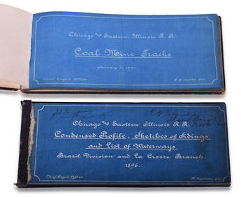
Chicago & Eastern Illinois Railroad 1901 Coal Mine Track and 1896 Brazil Division Track Chart BooksRail & Road Auctions4.6(165)See Sold PriceMar 08, 2024
1852 CHART SHOWING POSITIONS of DAVIS'S SOUTH SHOAL & OTHER DANGERS antiqueJasper524.5(9.9k)See Sold PriceFeb 27, 2024
Map of Part of the West Indies, Etc., Showing the Exact Position Of The U.S. War Steamer SanJasper524.5(9.9k)See Sold PriceFeb 27, 2024
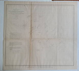
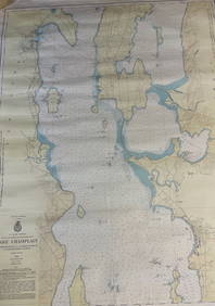
CHART: U.S LAKE SURVEYS/ LAKE CHAMPLAIN/ CUMBERLAND HEAD, NY and SAVAGE ISLAND, VT. TO FOUR BROTHERSChurchill Galleries3.7(217)See Sold PriceFeb 26, 2024


![ANSON, GEORGE. [Atlas to:] A Voyage Round the World, in (1 of 1)](https://p1.liveauctioneers.com/199/171650/86487370_1_x.jpg?height=282&quality=70&version=1592430092)