ATLAS of ANTIENT GEOGRAPHY by SAMUEL BUTLER 1843John McInnis Auctioneers,LLC4.6(502)See Sold PriceFeb 24, 2024
18TH C. ANTIQUE MAP: FRENCH & INDIAN WAR, FRAMEDThomaston Place Auction Galleries4.4(386)See Sold PriceFeb 24, 2024
Rand McNally Railroad Map Cabinet w/ 21 Railroad MapsRail & Road Auctions4.6(165)See Sold PriceMar 08, 2024
Keith Haring - Ink on New York Map, Best Buddies, Inscribed, Signed, and DatedSapphire Auction Gallery4(67)See Sold PriceMar 02, 2024
LATE 17TH C. FRENCH MAP OF THE NEW WORLD BY ALEXIS-HUBERT JAILLOT (1632-1712)Thomaston Place Auction Galleries4.4(386)See Sold PriceFeb 24, 2024
Central Railroad of New Jersey Map of Sandy Hook Route-ca. 1903JM Hobby Supply and Railroad Artifact Auctions4.4(126)See Sold PriceFeb 24, 2024
Lot of Six Mixed Atlas Box Cars-HO Scale-New in BoxJM Hobby Supply and Railroad Artifact Auctions4.4(126)See Sold PriceFeb 25, 2024
Rand McNally/Santa Fe Railroad Map of Iowa-1912JM Hobby Supply and Railroad Artifact Auctions4.4(126)See Sold PriceFeb 24, 2024
NICOLAES VISSCHER (NETHERLANDS, 1618-1709) MAP OF THE NEW WORLDThomaston Place Auction Galleries4.4(386)See Sold PriceFeb 24, 2024
17TH C. WORLD MAP BY NICOLAES VISSCHER (NETHERLANDS, 1618-1709)Thomaston Place Auction Galleries4.4(386)See Sold PriceFeb 24, 2024
Lot of Six Mixed Atlas Cabooses-HO Scale-New in BoxJM Hobby Supply and Railroad Artifact Auctions4.4(126)See Sold PriceFeb 25, 2024
EAST ASIA China Chinese Turkistan Tibet Korea Japan.TITLE/CONTENT OF MAP: 'Chinese Empire & Japan; Inset maps of Canton; Peking' DATE PRINTED: 1912 IMAGE SIZE: Approx 32.5 x 43.0cm, 12.75 x 17 inches (Large); Please note that this is a folding map. TYPSee Sold Price
EAST ASIA China Chinese Turkistan Tibet Korea Japan.TITLE/CONTENT OF MAP: 'Chinese Empire & Japan; Inset maps of Canton; Peking' Date: 1912 IMAGE SIZE: Approx 32.5 x 43.0cm, 12.75 x 17 inches (Large); Please note that this is a folding map. TYPE: AntiqSee Sold Price
EAST ASIA China Chinese Turkistan Tibet Korea Japan. Hong Kong Peking 1912 mapTITLE/CONTENT OF MAP: 'Chinese Empire & Japan; Inset maps of Canton; Peking' DATE PRINTED: 1912 IMAGE SIZE: Approx 32.5 x 43.0cm, 12.75 x 17 inches (Large); Please note that this is a folding map. TYPSee Sold Price
EAST ASIA. China Chinese Turkistan Tibet Korea Japan. HK Peking Beijing 1901 mapTITLE/CONTENT OF MAP: 'Chinese Empire & Japan; Inset maps of Canton; Peking' DATE PRINTED: 1901 IMAGE SIZE: Approx 32.0 x 43.0cm, 12.75 x 17 inches (Large); Please note that this is a folding map. TYPSee Sold Price
EAST ASIA. shows independent Tibet & Sin-Kiang (Xinjiang) . Korea 1952 old mapTITLE/CONTENT OF MAP: 'China and Japan' The map shows Tibet as an independent entity as it existed prior to the Chinese annexation in 1950 DATE PRINTED: 1952 IMAGE SIZE: Approx 33.5 x 44.0cm, 13 x 17.See Sold Price
EAST ASIA. shows independent Tibet & Sin-Kiang (Xinjiang) . Korea 1952 old mapTITLE/CONTENT OF MAP: 'China and Japan' The map shows Tibet as an independent entity as it existed prior to the Chinese annexation in 1950 DATE PRINTED: 1952 IMAGE SIZE: Approx 33.5 x 44.0cm, 13 x 17.See Sold Price
EAST ASIA. 'Chinese Empire & Japan'. China Korea Formosa. BARTHOLOMEW 1876 mapTITLE/CONTENT OF MAP: 'Chinese Empire & Japan' DATE PRINTED: 1876 IMAGE SIZE: Approx 23.5 x 31.0cm, 9.25 x 12 inches (Large); Please note that this is a folding map. TYPE: Antique colour map CONDITIONSee Sold Price
EAST ASIA Chinese Empire Japan China Mongolia Soongaria Tibet. COLLINS 1873 mapTITLE/CONTENT OF MAP: 'Chinese Empire & Japan' DATE PRINTED: 1873 IMAGE SIZE: Approx 23.5 x 31.0cm, 9.25 x 12.25 inches (Large); Please note that this is a folding map. TYPE: Antique colour map CONDITSee Sold Price
Antique Map of East Asia - China - Japan - 19th Century - Korea - Central AsiaA fine first edition example of M. Lapie's 1832 map of the Chinese empire and Japan. The map covers all of China, Korea, and Japan from Asiatic Russia to India and the Sea of China and from IndependenSee Sold Price
EAST ASIA Chinese Empire Japan China Mongolia Soongaria Tibet. COLLINS 1873 mapTITLE/CONTENT OF MAP: 'Chinese Empire & Japan' DATE PRINTED: 1873 IMAGE SIZE: Approx 23.5 x 31.0cm, 9.25 x 12.25 inches (Large); Please note that this is a folding map. TYPE: Antique colour map CONDITSee Sold Price
Original Antique Map - China - Korea - Japan - 19th Century - East Asia - LapieA fine first edition example of M. Lapie's 1832 map of the Chinese empire and Japan. The map covers all of China, Korea, and Japan from Asiatic Russia to India and the Sea of China and from IndependenSee Sold Price
Original Antique Map of Asia - China - Japan - 19th Century - East Asia - LapieA fine first edition example of M. Lapie's 1832 map of the Chinese empire and Japan. The map covers all of China, Korea, and Japan from Asiatic Russia to India and the Sea of China and from IndependenSee Sold Price
EAST ASIA China Japan Korea Formosa Taiwan JOHNSTON 1901 old antique map chartTITLE/CONTENT OF MAP: 'China and Japan' DATE PRINTED: 1901 IMAGE SIZE: Approx 36.5 x 46.5cm, 14.25 x 18.25 inches (Large); Please note that this is a folding map. TYPE: Antique colour map CONDITION: GSee Sold Price
EAST ASIA China Japan Korea Formosa Taiwan JOHNSTON 1901 old antique map chartTITLE/CONTENT OF MAP: 'China and Japan' DATE PRINTED: 1901 IMAGE SIZE: Approx 36.5 x 46.5cm, 14.25 x 18.25 inches (Large); Please note that this is a folding map. TYPE: Antique colour map CONDITION: GSee Sold Price
EAST ASIA. China Philippines Japan Korea Siam French Indochina Malaya 1920 mapTITLE/CONTENT OF MAP: 'Asia (General)' DATE PRINTED: 1920 IMAGE SIZE: Approx 33.0 x 22.0cm, 13 x 8.75 inches (Large) TYPE: Vintage colour map; Scale 1:29,500,000 CONDITION: Good; suitable for framing.See Sold Price
EAST ASIA. Chinese Empire and Japan. Korea. BARTHOLOMEW 1890 old antique mapTITLE/CONTENT OF MAP: 'Chinese Empire and Japan' DATE PRINTED: 1890 IMAGE SIZE: Approx 29.5 x 43.0cm, 11.75 x 16.75 inches (Large); Please note that this is a folding map. TYPE: Antique colour map CONSee Sold Price
EAST ASIA. Eastern China Central Japan Korea. BARTHOLOMEW 1898 old antique mapTITLE/CONTENT OF MAP: 'Eastern China & Central Japan; Inset map of Tokio; Tozando' DATE PRINTED: 1898 IMAGE SIZE: Approx 43.5 x 32.5cm, 17 x 12.75 inches (Large); Please note that this is a folding maSee Sold Price
EAST ASIA. Chinese Empire and Japan. Korea. BARTHOLOMEW 1890 old antique mapTITLE/CONTENT OF MAP: 'Chinese Empire and Japan' DATE PRINTED: 1890 IMAGE SIZE: Approx 29.5 x 43.0cm, 11.75 x 16.75 inches (Large); Please note that this is a folding map. TYPE: Antique colour map CONSee Sold Price
Sold7V FAR EAST BIBLIOGRAPHY Japan China Korea TibetThis auction lot includes the following group of titles: - Bibliofgraphy of the Philippine Islands by U.S.Senate - Dated 1903 by Government Printing - A Bibliography of Studies and Traslations of MSee Sold Price
EAST ASIA. China Japan Japanese occupied Korea Formosa Taiwan. 1924 old mapTITLE/CONTENT OF MAP: 'China and Japan' DATE PRINTED: 1924 IMAGE SIZE: Approx 33.5 x 43.0cm, 13.25 x 17 inches (Large) TYPE: Vintage colour map; Scale 1:15,000,000. This map was originally printed onSee Sold Price
North-east China Korea Japan Russian Far East. North East Asia. TIMES 1958 mapCAPTION PRINTED BELOW PICTURE: 'China north-east // Korea // Sea of Japan' DATE PRINTED: 1958 IMAGE SIZE: Approx 59.0 x 47.5cm, 23.25 x 18.75 inches (Large); Please note that this is a folding map. TYSee Sold Price
North-east China Korea Japan Russian Far East. North East Asia. TIMES 1958 mapTITLE/CONTENT OF MAP: 'China north-east // Korea // Sea of Japan' DATE PRINTED: 1958 IMAGE SIZE: Approx 59.0 x 47.5cm, 23.25 x 18.75 inches (Large); Please note that this is a folding map. TYPE: VintaSee Sold Price
SoldJohnston: Antique Map of the Chinese Empire, 1900Title/Content of Map: 'China' CHINESE EMPIRE. China East Asia Tibet Mongolia East Turkestan Korea Date Printed: 1900 Image Size: Approx 20.5 x 27.0cm, 8 x 10.5 inches (Medium) Type: Antique colour mapSee Sold Price
SIBERIA & CHINESE TARTARY Manchuria Mongolia Korea China East Asia SDUK 1844 mapTITLE/CONTENT OF MAP: 'SIBERIA AND CHINESE TARTARY.' DATE PRINTED: This map was originally published by The Society for the Diffusion of Useful Knowledge in 1838; this date is printed on the map. ThisSee Sold Price
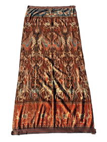
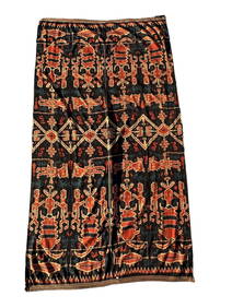
A Fine RARE Antique Woven ikat Pictorial TextilePremier Auction Galleries4.3(329)See Sold PriceMar 09, 2024
Pair of Alpine Black Swallowtail in Framed Showing Its Spring and Summer FormWeatherham Estate Treasures3.9(157)See Sold PriceFeb 29, 2024
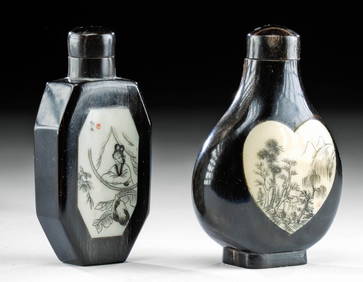
Chinese Enameled Copper Snuff Box w/ Ivory FiguresArtemis Fine Arts4.8(1.4k)See Sold PriceFeb 26, 2024
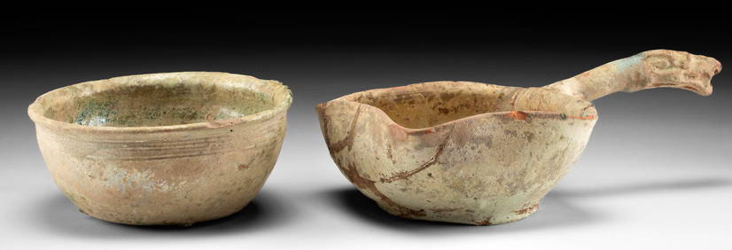
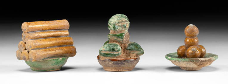
Chinese Ming Glazed Mingqi / Food Offerings, 3pcsArtemis Fine Arts4.8(1.4k)See Sold PriceFeb 26, 2024
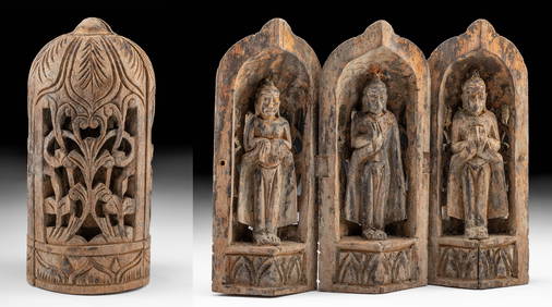
19th C. Chinese Folding Wood Travel Altar, 3 GuanyinArtemis Fine Arts4.8(1.4k)See Sold PriceFeb 26, 2024
20th C. Chinese Mixed Media Paintings - Wind DeitiesArtemis Fine Arts4.8(1.4k)See Sold PriceFeb 26, 2024
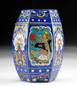
Vintage Chinese Qing Dynasty Enameled Brass VesselArtemis Fine Arts4.8(1.4k)See Sold PriceFeb 26, 2024
Chinese Clair-de-Lune Censer With Japanese Silver TopLion and Unicorn4.7(1.8k)See Sold PriceMar 12, 2024
Artifact Bundle - Roman, Chinese, Sumerian, LuristanArtemis Fine Arts4.8(1.4k)See Sold PriceFeb 26, 2024
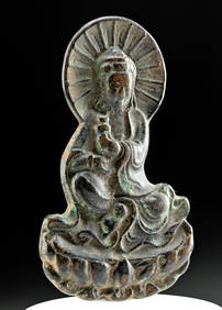
Chinese Ming Dynasty Bronze Plaque Buddha Atop LotusArtemis Fine Arts4.8(1.4k)See Sold PriceFeb 26, 2024
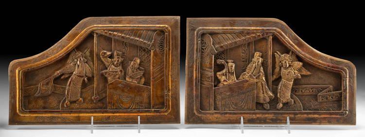
19th C. Chinese Qing Wood Relief Panels for Martial BedArtemis Fine Arts4.8(1.4k)See Sold PriceFeb 26, 2024