Hondius (Henricus) 27 maps of FranceHondius (Henricus) Gouvernement de l'Isle de France,and 26 other regional maps of France, including Champagne, Burgundy, Brittany, Anjou, Languedoc and elsewhere, all with decorative title carSee Sold Price
Saintonge France Map byJodocus & Henricus Hondius, 1619Pais de Xantoigne / Amstelodami, excusum apud Iudocum et Henricum Hondium | Title: Carte du Pais de Xaintonge | Authors: Jodocus Hondius & Henricus Hondius | Date: 1619 - 1628 | Type: Atlas [TopographSee Sold Price
SoldHondius. Gouvernement de l'Isle de FranceHondius (Henricus) Gouvernement de l'Isle de France,and 26 other regional maps of France, including Champagne, Burgundy, Brittany, Anjou, Languedoc and elsewhere, all with decorative title carSee Sold Price
SoldTwo European Maps, Rugen Germany and FranceOne an engraving with hand colored double page map, Galliae, Henricus Hondius, 1639, the other Nova Famigerabilius insulae ac ductatus Rugiae descprtion, engraved hand colored double-page map, JohannSee Sold Price
Hondius Map of Virginia, 1630HONDIUS, Henricus (1573 –1650), after John Smith (1580-1631). Nova Virginiae Tabula. Engraving with original hand color. Amsterdam, c. 1630. 19” x 23” sheet, 24” x 27 3/4&rdquSee Sold Price
SoldHondius (Henricus) GalliaeHondius (Henricus) Galliae,France and its tribes, with decorative title cartouche, compass rose, ships and sea monsters, engraved map, 368 x 495mm., central vertical fold, with splitting in thSee Sold Price
Hondius (Henricus) GalliaeHondius (Henricus) Galliae,France and its tribes, with decorative title cartouche, compass rose, ships and sea monsters, engraved map, 368 x 495mm., central vertical fold, with splitting in thSee Sold Price
SoldHondius (Henricus) GalliaeHondius (Henricus) Galliae,France and its tribes, with decorative title cartouche, compass rose, ships and sea monsters, engraved map, 368 x 495mm., central vertical fold, with splitting in thSee Sold Price
SoldHondius. Nova Virginiae Tabula. 1647.[America/ Virgina] Hondius, Henricus. “Nova Virginae Tabula.” Amsterdam, 1647. Engraved map. 19 3/8” x 15”. Framed: 27 3/4” x 23 1/2”. Text on verso in Latin. Hand-See Sold Price
SoldLe Pais de Caux Map After Henricus Hondius.Le Pais de Caux map. 19th century copy after the 1638 original by Henricus Hondius. Lined paper. Framed under glass. Sight: 15 1/2 x 20"; frame: 22 1/2" x 27".See Sold Price
Hondius (Henricus) FranceHondius (Henricus) Galliæ supra omnes in hac forma editiones locu pletissima et exactissima descriptio,France, with decorative title cartouche of allegorical figures, lower left, large compassSee Sold Price
SoldHondius (Henricus). Map England (c.1640)-. Hondius (Henricus) Warwicum Northamtonia Huntingdonia Cantabrigia Suffolcia Oxonium Buckinghamia Bedfordia Hardfordia Essexia Berceria Middelsexia Southantonia Surria Cantium et Southsexia,See Sold Price
SoldNOVA TOTIVS World Map Henricus HondiusMarked on top Nova Totivs terrarvm Orbis geographica ac Hydrographica tabvla. author Henricus Hondius Depicts the geographic and hydrographic map of the world, possibly made of gold foil Framed withinSee Sold Price
SoldHenricus Hondius MapsMAPS. Henricus Hondius, two celestial maps with constellations and signs of the zodiac; Haemisphaeri Graphicum Coeli ti et, VM Sceno Australe Stella Terra and Hemisphae Alis Coeli Sphaeri Gra- RII BorSee Sold Price
SoldConstellation maps Henricus Hondius(lot of 2) Framed constellation maps, ''Hemisphaeri Graphicum'' (later printings) after Henricus Hondius (Dutch, 1597-1651), each plate signed and dated 1661 lower right, each overall: 20''h x 22''w.See Sold Price
SoldHONDIUS, Henricus. 2 framed mapsHONDIUS, Henricus. Frisia Occidentalis Auctoribus Adriano Merio et Geraldo Freitag. Amsterdam. ca. 1700 century.38cm x 49.8cm (15" x 19.5") plate mark Sold with: Geldria Dvcatvs et Zvtfania Comitavs 3See Sold Price
Hondius (Henricus) 3 regional maps of SpainHondius (Henricus) Ducatus Holsatiæ Nova Tabula,southern Denmark, with 2 inset maps in upper corners, compass roses and a ship, engraved map, 380 x 510mm., French text verso, central verticalSee Sold Price
Hondius (Henricus) 3 regional maps of SpainHondius (Henricus) Gallæcia Regnum; Castiliæ Veteris et Novæ Descriptio; Novissima Arragoniæ Regni Tabula,3 regional maps of Spain, with decorative title cartouches, the first also with ships,See Sold Price
SoldHENRICUS HONDIUS Map of the WorldHENRICUS HONDIUS Map of the World, hand colored, inscriptions to piece in Latin, label to reverse reads ‘Pincus Art Shop’, subject a map of the world accompanied by sea scenes, measures 17 x 21 1/See Sold Price
SoldHenricus Hondius map of PeruCartographer: Henricus Hondius Title: Peru Subject: Peru, South America Published: Amsterdam Date: c. 1630 Description: The map shows the territory of Peru, flanked to the north by the Equator and whaSee Sold Price
SoldHenricus Hondius map of ChileCartographer: Henricus Hondius Title: Chili Subject: Chile, South America Published: Amsterdam Date: c. 1630 Description: Map of Chile shows the Chonos Archipelago and Socorro Island in the Chilean SeSee Sold Price
SoldMap, Henricus Hondius the YoungerHenricus Hondius the Younger (Dutch, 1597-1651), "India Orientalis," 1609, hand-colored engraving, image (sight): 14"h x 19"w, sheet (unframed): 17.25"h x 21.25"w. Provenance: Estate of Frank J. CaufiSee Sold Price
SoldHenricus Hondius map of BrazilCartographer: Henricus Hondius Title: Accuratissima Brasilia Tabula Subject: Brazil Published: Amsterdam Date: c. 1630 Description: Map includes insets of the Baia de Todos os Sanctos and the city ofSee Sold Price
SoldAstrological Map, Henricus HondiusHenricus Hondius (Dutch, 1573 –1650), "Hemisphaeriis Borealis Coeli et Terrae Sphaerica Scenographia," hand-colored copper engraving, overall (with matting): 21.5"h x 24.5"w. Note: This map is likelSee Sold Price
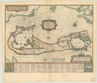
RARE 1638 HONDIUS MAP OF BERMUDA, FRAMEDThomaston Place Auction Galleries4.4(386)See Sold PriceFeb 24, 2024
Henri Matisse (French, 1869-1954) - Portrait de Paul LéautaudFreeman's | Hindman4.5(158)See Sold PriceFeb 27, 2024
Auguste Moreau Carrara Marble Sculpture H: 27" FranceCarstens Galleries4.5(128)See Sold PriceMar 01, 2024
Jules Dupre Oil on Paper Art: 11.3" x 17" Frame: 21" x 27" FranceCarstens Galleries4.5(128)See Sold PriceMar 01, 2024
Antique Map of France, 1703 by Gillaume Del Isle PrintAntiques Online Auctions4.6(407)See Sold PriceMar 14, 2024
Galliae Regionis Nova Descriptio Hand Colored Map of France on Laid Paper, Ca. 16th Century, H 10" WDuMouchelles4.6(825)See Sold PriceMar 15, 2024