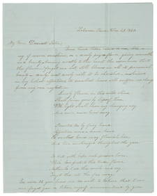
1952 MAY, J.F.K. HANDWRITTEN LETTER & ENVELOPEJohn McInnis Auctioneers,LLC4.6(504)See Sold PriceFeb 25, 2024
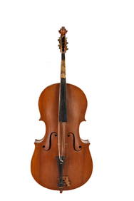
WARNER BECKMAN'S TIGER MAPLE CELLO / SEABROOK NHJohn McInnis Auctioneers,LLC4.6(504)See Sold PriceFeb 25, 2024
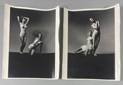
Victor Skrebneski Lingerie Fashion PhotographsEpic Auctions and Estate Sales4.6(204)See Sold PriceMar 02, 2024
[DOUGLASS, Frederick (1818-1895)]. ROBERTS, J.B., photographer. CDV of Frederick Douglass.Freeman's | Hindman4.4(1.6k)See Sold PriceFeb 27, 2024
1952 J.F.K. for SENATE TEAS & RECEPTION MATERIALJohn McInnis Auctioneers,LLC4.6(504)See Sold PriceFeb 25, 2024
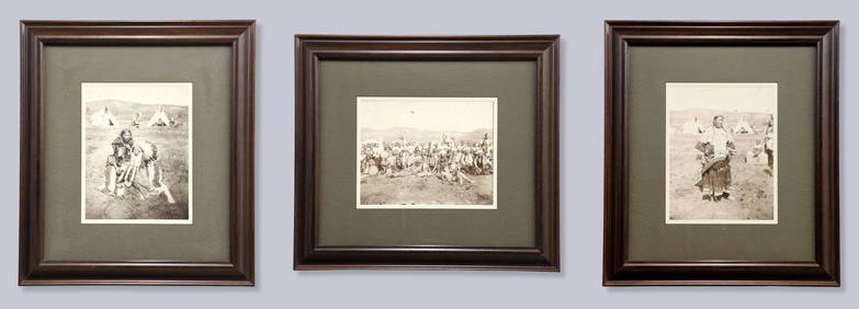
HUGH D. AUCHINCLOSS' 70th BIRTHDAY with FAMILYJohn McInnis Auctioneers,LLC4.6(504)See Sold PriceFeb 25, 2024
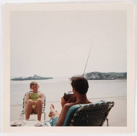
CAROLINE KENNEDY at BAILEYS BEACH, NEWPORT, RIJohn McInnis Auctioneers,LLC4.6(504)See Sold PriceFeb 25, 2024
WILLIAM LINSMAN PHOTO SIGNED by JACKIE KENNEDYJohn McInnis Auctioneers,LLC4.6(504)See Sold PriceFeb 25, 2024
SoldMap, Henricus Hondius the YoungerHenricus Hondius the Younger (Dutch, 1597-1651), "India Orientalis," 1609, hand-colored engraving, image (sight): 14"h x 19"w, sheet (unframed): 17.25"h x 21.25"w. Provenance: Estate of Frank J. CaufiSee Sold Price
SoldMap, Henricus Hondius the YoungerHenricus Hondius the Younger (Dutch, 1597-1651), "India Orientalis," 1609, hand-colored engraving, image (sight): 14"h x 19"w, overall (with frame): 26.5"h x 31"w. Provenance: Estate of Frank J. CaufiSee Sold Price
SoldEngraved Portrait, Henricus HondiusFrederik Bouttats the Younger. "Henricus Hondius." Ca. 1660s. Engraving on laid folio sheet, measured from plate-lines 167 x 114mm. Verso with some pencil notes and seller's ink-stamp, some minor staiSee Sold Price
Sold17th C. Dutch Map of Castille by Henricus HondiusHenricus Hondius II or Hendrick Hondius the Younger (Dutch, 1597-1651). Place and date of publication: Amsterdam, ca. 1635-1666. A copperplate engraved detailed map of the central kingdom of Castile aSee Sold Price
SoldNOVA TOTIVS World Map Henricus HondiusMarked on top Nova Totivs terrarvm Orbis geographica ac Hydrographica tabvla. author Henricus Hondius Depicts the geographic and hydrographic map of the world, possibly made of gold foil Framed withinSee Sold Price
SoldAstrological Map, Henricus HondiusHenricus Hondius (Dutch, 1573 –1650), "Hemisphaeriis Borealis Coeli et Terrae Sphaerica Scenographia," hand-colored copper engraving, overall (with matting): 21.5"h x 24.5"w. Note: This map is likelSee Sold Price
SoldConstellation map Henricus HondiusFramed constellation map, ''Hemisphaerium Australe'' (later printing), after Henricus Hondius (Dutch, 1597-1651), overall: 19''h x 22.5''w.See Sold Price
SoldConstellation maps Henricus Hondius(lot of 2) Framed constellation maps, ''Hemisphaeri Graphicum'' (later printings) after Henricus Hondius (Dutch, 1597-1651), each plate signed and dated 1661 lower right, each overall: 20''h x 22''w.See Sold Price
SoldHenricus Hondius MapsMAPS. Henricus Hondius, two celestial maps with constellations and signs of the zodiac; Haemisphaeri Graphicum Coeli ti et, VM Sceno Australe Stella Terra and Hemisphae Alis Coeli Sphaeri Gra- RII BorSee Sold Price
SoldTwo 19/20th C. Colored Hondius Astrological MapsTwo late 19th/early 20th Century hand-colored astrological maps (Henricus Hondius), 16 1/2" x 19" and 23 1/2" x 25 1/2", note watermark.See Sold Price
SoldTwo 19 C. Hand Colored Hondius Astrological MapsTwo late 19th Century hand-colored astrological maps (Henricus Hondius), 16 1/2" x 19" and 23 1/2" x 25 1/2", note watermark.See Sold Price
SoldCelestial Map After Henricus Hondius (Dutch, 1597-1651)Celestial Map After Henricus Hondius (Dutch, 1597-1651). Reprint. Plate signed and dated 1661. Size: 18'' x 20'', 46 x 51 cm (plate); 18.75'' x 23'', 48 x 58 cm (sheet).See Sold Price
SoldAntique Map by Henricus HondiusHenricus Hondius (17th c.), "America Noviter Delineata," 1641, copper engraved map with hand-coloring, later printing likely 20th Century, overall (framed): 19.5"h x 23.5"wSee Sold Price
Sold2 Antique Map Prints Henricus Hondius, Frederik de Wit2 reproduction prints of antique maps * * * Artist: Henricus HondiusTitle: Antique Map of the WorldMedium: Giclee on paperPaper size: 13 3/4 x 17 7/8 inches * * * * Artist: Frederik de WitTitle: NovaSee Sold Price
Antique Celestial Map by Henricus Hondius Hand ColoredPrinted by Alis Coeli, hand colored gravure. The dimensions are Approx. 20"x 17.5" (Plate dimensions). ABOUT SHIPPING: This lot is located in Boca Raton, Fl and its shipment will be made directly by ASee Sold Price
Saintonge France Map byJodocus & Henricus Hondius, 1619Pais de Xantoigne / Amstelodami, excusum apud Iudocum et Henricum Hondium | Title: Carte du Pais de Xaintonge | Authors: Jodocus Hondius & Henricus Hondius | Date: 1619 - 1628 | Type: Atlas [TopographSee Sold Price
2 Antique Map Prints Henricus Hondius, Frederik de Wit2 reproduction prints of antique maps * * * Artist: Henricus HondiusTitle: Antique Map of the WorldMedium: Giclee on paperPaper size: 13 3/4 x 17 7/8 inches * * * * Artist: Frederik de WitTitle: NovaSee Sold Price
Sold2 Antique Map Prints Henricus Hondius, Frederik de Wit2 reproduction prints of antique maps * * * Artist: Henricus HondiusTitle: Antique Map of the WorldMedium: Giclee on paperPaper size: 13 3/4 x 17 7/8 inches * * * * Artist: Frederik de WitTitle: NovaSee Sold Price
SoldLe Pais de Caux Map After Henricus Hondius.Le Pais de Caux map. 19th century copy after the 1638 original by Henricus Hondius. Lined paper. Framed under glass. Sight: 15 1/2 x 20"; frame: 22 1/2" x 27".See Sold Price
Sold1633 Map Nova Virginiae Tabula - Henricus HondiusNova Virginiae Tabula map by Henricus Hondius (1597-1651). Undated, published circa 1633. This map is the 5th derivative of John Smith's 1612 map of Virginia, which was the first printed map of the ChSee Sold Price
SoldTwo European Maps, Rugen Germany and FranceOne an engraving with hand colored double page map, Galliae, Henricus Hondius, 1639, the other Nova Famigerabilius insulae ac ductatus Rugiae descprtion, engraved hand colored double-page map, JohannSee Sold Price
SoldOrcadum et Schetlandiae Insularum Map after Hondius.Orcadum et Schetlandiae Insularum Map after Henricus Hondius, 1650. Dimensions: sight: - 15.125" H x 19.375" W; See Sold Price
MAP - Mid-Atlantic US. HondiusColonial Mid-Atlantic United States. Hondius/Schenk & Valck, Nova Virginiae Tabula, 1700 (circa). Hand Color. This graphic map is Henricus Hondius' version of Capt. John Smith's important map of 1612,See Sold Price
SoldNOVA TOTIUS TERRARUM ORBIS GEOGRAPHICA MAPNOVA TOTIUS TERRARUM ORBIS GEOGRAPHICA MAP Nova Totius Terrarum Orbis Georgraphica map by Henricus Hondius (1597-1651, Dutch). Gold foil framed map was created 1630. Size: Framed 18 x 23" Map 11 x 15"See Sold Price
LATE 17TH C. FRENCH MAP OF THE NEW WORLD BY ALEXIS-HUBERT JAILLOT (1632-1712)Thomaston Place Auction Galleries4.4(389)See Sold PriceFeb 24, 2024
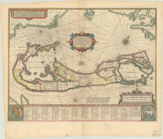
RARE 1638 HONDIUS MAP OF BERMUDA, FRAMEDThomaston Place Auction Galleries4.4(389)See Sold PriceFeb 24, 2024
18TH C. ANTIQUE MAP: FRENCH & INDIAN WAR, FRAMEDThomaston Place Auction Galleries4.4(389)See Sold PriceFeb 24, 2024
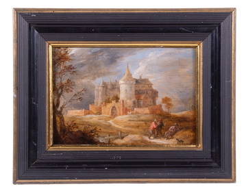
DAVID TENIERS, THE YOUNGER (FLEMISH, 1610-1690)Thomaston Place Auction Galleries4.4(389)See Sold PriceFeb 24, 2024
Keith Haring - Ink on New York Map, Best Buddies, Inscribed, Signed, and DatedSapphire Auction Gallery4.1(67)See Sold PriceMar 02, 2024
Rand McNally Railroad Map Cabinet w/ 21 Railroad MapsRail & Road Auctions4.6(165)See Sold PriceMar 08, 2024
Putnam - First Map of the State of Ohio by Rufus PutnamTrillium Antique Prints & Rare Books4.5(30)See Sold PriceFeb 24, 2024
1636 MAP of SWITZERLAND DAS WIFISPURGERGOU antique 15 by 19"Jasper524.5(9.8k)See Sold PriceFeb 27, 2024


![[DOUGLASS, Frederick (1818-1895)]. ROBERTS, J.B., photographer. CDV of Frederick Douglass. (1 of 2)](https://p1.liveauctioneers.com/197/319238/171467829_1_x.jpg?height=282&quality=70&version=1707520367)