ATLAS of ANTIENT GEOGRAPHY by SAMUEL BUTLER 1843John McInnis Auctioneers,LLC4.6(502)See Sold PriceFeb 24, 2024
18TH C. ANTIQUE MAP: FRENCH & INDIAN WAR, FRAMEDThomaston Place Auction Galleries4.4(386)See Sold PriceFeb 24, 2024
Rand McNally Railroad Map Cabinet w/ 21 Railroad MapsRail & Road Auctions4.6(165)See Sold PriceMar 08, 2024
Keith Haring - Ink on New York Map, Best Buddies, Inscribed, Signed, and DatedSapphire Auction Gallery4(67)See Sold PriceMar 02, 2024
LATE 17TH C. FRENCH MAP OF THE NEW WORLD BY ALEXIS-HUBERT JAILLOT (1632-1712)Thomaston Place Auction Galleries4.4(386)See Sold PriceFeb 24, 2024
Central Railroad of New Jersey Map of Sandy Hook Route-ca. 1903JM Hobby Supply and Railroad Artifact Auctions4.4(126)See Sold PriceFeb 24, 2024
Lot of Six Mixed Atlas Box Cars-HO Scale-New in BoxJM Hobby Supply and Railroad Artifact Auctions4.4(126)See Sold PriceFeb 25, 2024
Rand McNally/Santa Fe Railroad Map of Iowa-1912JM Hobby Supply and Railroad Artifact Auctions4.4(126)See Sold PriceFeb 24, 2024
NICOLAES VISSCHER (NETHERLANDS, 1618-1709) MAP OF THE NEW WORLDThomaston Place Auction Galleries4.4(386)See Sold PriceFeb 24, 2024
17TH C. WORLD MAP BY NICOLAES VISSCHER (NETHERLANDS, 1618-1709)Thomaston Place Auction Galleries4.4(386)See Sold PriceFeb 24, 2024
Lot of Six Mixed Atlas Cabooses-HO Scale-New in BoxJM Hobby Supply and Railroad Artifact Auctions4.4(126)See Sold PriceFeb 25, 2024
NORTH AMERICA EAST. Canada USA. Canal Profiles. 1830TITLE/CONTENT OF MAP: 'NORTH AMERICA, CANADA AND THE UNITED STATES; inset canal profiles; table of 1830 census' DATE PRINTED: 1846 IMAGE SIZE: Approx 38.5 x 33.5cm, 15.25 x 13.25 inches (Large) TYPE:See Sold Price
NORTH AMERICA EAST. Canada USA. Canal Profiles. 1830TITLE/CONTENT OF MAP: 'NORTH AMERICA, CANADA AND THE UNITED STATES; inset canal profiles; table of 1830 census' Date: 1846 IMAGE SIZE: Approx 38.5 x 33.5cm, 15.25 x 13.25 inches (Large) TYPE: AntiqueSee Sold Price
SoldNORTH AMERICA EAST. Canada USA. Canal Profiles. 1830Reserve Reduced! TITLE/CONTENT OF MAP: 'NORTH AMERICA, CANADA AND THE UNITED STATES; inset canal profiles; table of 1830 census' DATE PRINTED: 1846 IMAGE SIZE: Approx 38.5 x 33.5cm, 15.25 x 13.25 inchSee Sold Price
NORTH AMERICA EAST Canada & USA. Canal profiles.TITLE/CONTENT OF MAP: 'NORTH AMERICA, CANADA AND THE UNITED STATES; inset canal profiles' DATE PRINTED: 1874 IMAGE SIZE: Approx 40.0 x 34.0cm, 15.75 x 13.25 inches (Large) TYPE: Antique steel engravedSee Sold Price
SoldNORTH AMERICA EAST Canada & USA. Canal profiles.TITLE/CONTENT OF MAP: 'NORTH AMERICA, CANADA AND THE UNITED STATES; inset canal profiles' DATE PRINTED: 1874 IMAGE SIZE: Approx 40.0 x 34.0cm, 15.75 x 13.25 inches (Large) TYPE: Antique steel engravedSee Sold Price
NORTH AMERICA EAST Canada & USA. Canal profiles.TITLE/CONTENT OF MAP: 'NORTH AMERICA, CANADA AND THE UNITED STATES; inset canal profiles' DATE PRINTED: 1874 IMAGE SIZE: Approx 40.0 x 34.0cm, 15.75 x 13.25 inches (Large) TYPE: Antique steel engravedSee Sold Price
NORTH AMERICA EAST Canada & USA. Canal profiles.TITLE/CONTENT OF MAP: 'NORTH AMERICA, CANADA AND THE UNITED STATES; inset canal profiles' DATE PRINTED: 1874 IMAGE SIZE: Approx 40.0 x 34.0cm, 15.75 x 13.25 inches (Large) TYPE: Antique steel engravedSee Sold Price
SDUK: Antique Map of North America, East, 1846Title/Content of Map: 'NORTH AMERICA, CANADA AND THE UNITED STATES; inset canal profiles; table of 1830 census' Date Printed: 1846 Image Size: Approx 38.5 x 33.5cm, 15.25 x 13.25 inches (Large) Type:See Sold Price
SDUK: Antique Map of NORTH AMERICA EAST, 1846TITLE/CONTENT OF MAP: 'NORTH AMERICA, CANADA AND THE UNITED STATES; inset canal profiles; table of 1830 census' DATE PRINTED: 1846 IMAGE SIZE: Approx 38.5 x 33.5cm, 15.25 x 13.25 inches (Large) TYPE:See Sold Price
SoldBowen, Thomas 1789 Map of North America. USA Canada"A New & Accurate Map of North America including Nootka Sound, with the new discovered Islands on the North East Coast of Asia" Copper Engraved Map Published 1789-91 by C. Cooke, London for "The New RSee Sold Price
SoldBarlow 1807 Antique Map of North America. USA CanadaCopper Engraved Map Published 1807 by Brightly & Kinnersley, Bungay, England for "A General View of the World, Geographical, Historical and Philosophical" by The Rev. E. Blomfield. Maps Engraved by BaSee Sold Price
SoldWalker, John 1795 Map of North America. USA CanadaCopper Engraved Map Published 1795, London for "Elements of Geography, and of Natural and Civil History" by John Walker. Centre fold as published. Paper Size: 10 x 8.5 inch (26 x 22cm) Split on centreSee Sold Price
Hunting in North America USA Canada 1873 RevoilCHASSES DANS L'AMERIQUE DU NORD PAR BENEDICT HENRY REVOIL NOUVELLE EDITION ILLUSTREE PAR YAN'DARGENT TOURS ALFRED MAME ET FILS EDITEURS MDCCCLXXII Edition of 1873 of these memories of hunting by the hSee Sold Price
North America Sheet II East Canada and New BrunswickReserve Reduced! Title: North America Sheet II East Canada and New Brunswick With Part of New York, Vermont and Maine Publication Date: 1860 Cartographer: WALKER, J. & C. Publisher: EDWARD STANFORD/S.See Sold Price
SoldAntique Explorers Map of North America, 1903Title/Content of Map: 'North America' USA CANADA MEXICO: Explorers routes: Cabot Cortes Baffin Hudson Drake Date Printed: 1903 Image Size: Approx 38.5 x 28.0cm, 15.25 x 11 inches (Large); Please noteSee Sold Price
SoldBartholomew, John 1922 Lot of 6 Large Maps. USAIncl North America Political, USA - East, USA - Central, USA - West, North East States, and Sketch Plans of American Cities. Large Lithograph Maps Published 1922 by The Times, London for "The Times SuSee Sold Price
Bartholomew, John 1922 Lot of 6 Large Maps. USAIncl North America Political, USA - East, USA - Central, USA - West, North East States, and Sketch Plans of American Cities. Large Lithograph Maps Published 1922 by The Times, London for "The Times SuSee Sold Price
NORTH AMERICA INDUSTRIES. USA Canada. CoalfieldsTITLE/CONTENT OF MAP: 'North America (Industrial); Inset map of Delta of the Mississippi' DATE PRINTED: 1920 IMAGE SIZE: Approx 34.0 x 45.0cm, 13.25 x 17.5 inches (Large) TYPE: Vintage colour map CONDSee Sold Price
SoldMaps 19th Century Mixed Lot of 15Incl Asia Minor, Asia, Europe, Denmark, Manchester, Australia, Canada, USA, North America, UK, Germany, World Rainfall & Vegetation, Syria, Europe, Asia, and Nubia/Abyssinia. Lot of 15 sheets of MapsSee Sold Price
SoldWorld Views C1830-80 Lot of 21 Steel EngravingsIncl Canada, USA, North America, Switzerland, Germany, Holy Land, Italy, UK, France, India, Denmark, etc. Examples by Bartlett, Brockendon, Stanfield, Harding, Turner, Voyages and Travels, etc. PaperSee Sold Price
SoldMaps C1840-1905 Mixed Lot of 10 Antique MapsIncl Cape of Good Hope, Monmouthshire, South America, North Asia, East Canada, West Siberia, Scotland, Greece, Russia, and Turkey. Examples by Encyclopaedia Brittannica, Stieler, Butler, and Moule. PaSee Sold Price
Spanish North America. THOMSON. Texas, Mexico & Southwestern USA 1830 mapTitle: "Spanish North America". THOMSON. Texas, Mexico & Southwestern USA 1830 map Description: Spanish North America [northern part] by Drawn & engraved for John Thomson's "New General Atlas" (1830).See Sold Price
SDUK: Antique Map of Lake Superior, 1846Title/Content of Map: 'NORTH AMERICA, SHEET lV., Lake Superior' Canada USA Ontario Michigan. Fur trading posts. Date Printed: 1846 Image Size: Approx 33.5 x 41.0cm, 13.25 x 16 inches (Large) Type: AntSee Sold Price
SDUK: Antique Map of Lake Superior, Canada, 1846Title/Content of Map: 'NORTH AMERICA, SHEET lV., Lake Superior' Canada USA Ontario Michigan. Fur trading posts. Date Printed: 1846 Image Size: Approx 33.5 x 41.0cm, 13.25 x 16 inches (Large) Type: AntSee Sold Price
The Muller Horner Goose Decoy by Nathan Rowley Horner (1882-1942)Copley Fine Art Auctions4.5(40)See Sold PriceFeb 24, 2024
LARGE EARLY 18TH C. DUTCH CHART OF UPPER NORTH AMERICA, PIERRE MORTIER (1661-1711), FRAMEDThomaston Place Auction Galleries4.4(386)See Sold PriceFeb 24, 2024
Parker Duofold Jr Mandarin Yellow Fountain Pen SetNorth American Pen Auctions LTD4.3(9)See Sold PriceFeb 24, 2024
Parker Vacumatic Standard Green Fountain Pen SetNorth American Pen Auctions LTD4.3(9)See Sold PriceFeb 24, 2024
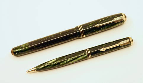
Parker 51 Aerometric Fountain Pen & Pencil Lot (5)North American Pen Auctions LTD4.3(9)See Sold PriceFeb 24, 2024
Joseph Antonio Hekking (Netherlands/ America 1830-1903)Nadeau's Auction Gallery4.7(401)See Sold PriceFeb 24, 2024
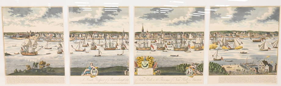
A South Prospect of Ye Flourishing City of New York in the Province of New York, North AmericaNadeau's Auction Gallery4.7(401)See Sold PriceFeb 24, 2024
A Field Guide To Wildflowers, Birds & Birds Nesting 3 Books from the Peterson Field Guide SeriesNorth American Artifact Auctions4.6(182)See Sold PriceApr 20, 2024
Audubon, Imperial Folio - Canada Lynx. 16Trillium Antique Prints & Rare Books4.5(30)See Sold PriceFeb 24, 2024
HERBERT BAYER (1900-1985) SKI IN ASPEN COLORADO.Swann Auction Galleries4.4(65)See Sold PriceFeb 29, 2024
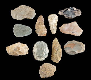
11 North American Eastern Woodland Knapped Stone BladesArtemis Fine Arts4.8(1.4k)See Sold PriceFeb 26, 2024
5 Inuit Stone Carvings - Animals, Boat, Head w/ FacesArtemis Fine Arts4.8(1.4k)See Sold PriceFeb 26, 2024
Early USA Ceremonial Fraternal Sword, Foster Son & Co.Artemis Fine Arts4.8(1.4k)See Sold PriceFeb 26, 2024
Early / Signed Chromolithograph - Venetian LandmarksArtemis Fine Arts4.8(1.4k)See Sold PriceFeb 26, 2024
Maison Jansen Pair of Bronze & Mirror Sconces H: 24" W: 16" FranceCarstens Galleries4.5(128)See Sold PriceMar 01, 2024
Map of United States of North America, 1785Antiques Online Auctions4.6(407)See Sold PriceMar 14, 2024
Herman Moll A New Map of Ye North Parts of AmericaWillow Auction House4.5(283)See Sold PriceMar 14, 2024
4th C. Sasanian Stone Intaglio Bearded Man w/ TurbanArtemis Fine Arts4.8(1.4k)See Sold PriceFeb 26, 2024