ATLAS of ANTIENT GEOGRAPHY by SAMUEL BUTLER 1843John McInnis Auctioneers,LLC4.5(505)See Sold PriceFeb 24, 2024
18TH C. ANTIQUE MAP: FRENCH & INDIAN WAR, FRAMEDThomaston Place Auction Galleries4.4(393)See Sold PriceFeb 24, 2024
Rand McNally Railroad Map Cabinet w/ 21 Railroad MapsRail & Road Auctions4.6(165)See Sold PriceMar 08, 2024
Keith Haring - Ink on New York Map, Best Buddies, Inscribed, Signed, and DatedSapphire Auction Gallery4(67)See Sold PriceMar 02, 2024
LATE 17TH C. FRENCH MAP OF THE NEW WORLD BY ALEXIS-HUBERT JAILLOT (1632-1712)Thomaston Place Auction Galleries4.4(393)See Sold PriceFeb 24, 2024
Central Railroad of New Jersey Map of Sandy Hook Route-ca. 1903JM Hobby Supply and Railroad Artifact Auctions4.4(127)See Sold PriceFeb 24, 2024
Lot of Six Mixed Atlas Box Cars-HO Scale-New in BoxJM Hobby Supply and Railroad Artifact Auctions4.4(127)See Sold PriceFeb 25, 2024
Rand McNally/Santa Fe Railroad Map of Iowa-1912JM Hobby Supply and Railroad Artifact Auctions4.4(127)See Sold PriceFeb 24, 2024
NICOLAES VISSCHER (NETHERLANDS, 1618-1709) MAP OF THE NEW WORLDThomaston Place Auction Galleries4.4(393)See Sold PriceFeb 24, 2024
17TH C. WORLD MAP BY NICOLAES VISSCHER (NETHERLANDS, 1618-1709)Thomaston Place Auction Galleries4.4(393)See Sold PriceFeb 24, 2024
Lot of Six Mixed Atlas Cabooses-HO Scale-New in BoxJM Hobby Supply and Railroad Artifact Auctions4.4(127)See Sold PriceFeb 25, 2024
Alaska map with native land protestsHeading: (Map - Alaska) Author: Title: Native Protest Map Place Published: [Washington, D.C.] Publisher: Date Published: 1968 Description: Blue line map (or xerographic?).See Sold Price
Alaska map with native land protestsHeading: (Alaska) Author: Title: Native Protest Map Place Published: [Washington, D.C.] Publisher: Date Published: 1968 Description: Blue line map (or xerographic?). 84x120See Sold Price
Alaska map with native land protestsHeading: (Alaska) Author: Title: Native Protest Map Place Published: [Washington, D.C.] Publisher: Date Published: 1968 Description: Blue line map (or xerographic?). 84x120See Sold Price
Sold(ARIZONA -- NAVAJO NATION.) Large lithographed folding(ARIZONA -- NAVAJO NATION.) Large lithographed folding map of Native American lands in northeastern Arizona. 2 sheets joined, 34x49 inches overall; folds lightly browned and reinforced on verso with sSee Sold Price
Sold18th Century Map of Tennessee with Native American land"Map of the Tennasee Government Formerly Part of North Carolina from the Latest Surveys, 1795," engraved by B. Tanner, published New York, J. Reid, L. Wayland & C. Smith, showing the Missisippi RiverSee Sold Price
Sold1759 Voyages Geography MAPS Native American Indians1759 Voyages Geography MAPS Native American Indians Asia Alaska Canada Prevost The ‘General History of Voyages’ by abbe Prevost is one of the largest and most impressive collections of stories ofSee Sold Price
SoldZatta map of Virginia & Carolinas.[U.S./Virginia & Carolinas]. Zatta. Il Paese De'Cherachesi, Con La Parte Occidentale Della Carolina Settentrionale, E Della Virginia. Double-page hand-colored engraved map, marking lands of Native AmeSee Sold Price
GLO maps of Oregon & AlaskaHeading: Author: United States General Land Office Title: Two maps of Alaska and one of Oregon from the General Land Office Place Published: Washington Publisher:General Land Office Date PublishSee Sold Price
SoldGLO maps of Oregon & AlaskaHeading: (Alaska & Oregon) Author: United States General Land Office Title: Two maps of Alaska and one of Oregon from the General Land Office Place Published: Washington Publisher:General Land OfficeSee Sold Price
Classical Land Map of the Mediterranean 1940.Classical Land Map of the Mediterranean. Date: 1940. The National Geographic Magazine. Editor: Gilbert Grosvenor. Measurement approximate: 35 x 26 . Shipping cost: $15.00 excluding Hawaii, Alaska & CaSee Sold Price
Sold3 Native American Items, incl. A. Zatta MapThree (3) Native American maps and engravings. 1st item: Luigiana Ingelise, Colla Parte Occidentale della Florida, della Giorgia, e Carolina Meridonale, Sheet 10, showing Native American lands, publisSee Sold Price
King Map of U.S. Territories, 1898King, Harry. ...United States and Territories Showing the Extent of Public Surveys. Lithographed map. Government Land Office, 1898. 58 ½" x 81" sheet. Inset shows only Alaska. Dates of acquisitionsSee Sold Price
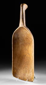
Sold[Map] The Alaska Line. Alaska Steamship Co.[Map] The Alaska Line. Alaska Steamship Co. Seattle: Frank McCaffrey, 1936. A pictorial map of the territory of Alaska with red dots and lines representing the Alaska Line routes, bordered by native ASee Sold Price
SoldNATIVE AMERICAN INDIAN LAND GRANTS a pair, one ChNATIVE AMERICAN INDIAN LAND GRANTS a pair, one Chippewa dated 1899 and a Winnebago dated 1901. Together with a scarce vintage "Cherokee Strip" Oklahoma map, circa 1880. Estimate $25-$50See Sold Price
SoldKootenay, Alaska Mining Districts Map Drawn in 1909This is a topo. map of East and West Kootenay drawn by the Lands and Works, Dept. in Victoria, B.C. scale is 1 in.= 8 miles. Mining districts are outlined in red. 28 in. X 33 in. In good condition twoSee Sold Price
SoldNative Art: 19th C. MapNative Art: 19th C. Map Cherokee - Nation of - Indians 1884 Cessions of Land. 34 x 32 inchesSee Sold Price
Sailing Sheltered Seas to the Land of the Midnight SunIllustrated booklet by Alaska Steamship Co. Missing pocket map. 10.75x7.75" Date: State/Country: Alaska City/County:See Sold Price
SoldSARAH TUCKER "RAINBOW IN THE NORTH" 1852First Establishment of Christianity in Rupert's Land London. James Nisbet and Co. hardcover 3/4 leather bound. Folding map and (11) engravings with Native AmericansSee Sold Price
SoldAlaskan Inuit Walrus Tusk Cribbage BoardAn Alaskan Inuit Walrus Tusk Cribbage Board, 20th c., incised with hunting scenes, animals of land and sea, and native tools, signed "Homer Apatiki Gambell, St. Lawrence Is. Alaska", length 24 1/2 inSee Sold Price
The Alaska Line. Alaska Steamship Co.The Alaska Line. Alaska Steamship Co. Seattle: Frank McCaffrey, 1936. Map of the territory of Alaska with red dots and lines representing the Alaska Line routes, bordered by native Alaskan totems. 21See Sold Price
Sold1889 Indian Reservation Map of the United StatesThis is a RARE 1889 map of Indian reservations in the United States. With the Indian Removal Act of 1830, the U.S. Government began moving Native American populations to secluded tracts of land. FromSee Sold Price
Sold1891 Indian Reservation Map of the United StatesThis is a RARE 1891 map of Indian reservations in the United States. With the Indian Removal Act of 1830, the U.S. Government began moving Native American populations to secluded tracts of land. FromSee Sold Price
SoldA map of the world on Mercators Projection. Davis Land. GENTS MAG 1755 oldTITLE/CONTENT OF MAP: 'A map of the World, on Mercators Projection' The map notes the European discovery of Alaska in 1741, and shows in dotted outline a pre-Cook guess at the east coast of Australia.See Sold Price
A map of the world on Mercators Projection. Davis Land. GENTS MAG 1755 oldTITLE/CONTENT OF MAP: 'A map of the World, on Mercators Projection' The map notes the European discovery of Alaska in 1741, and shows in dotted outline a pre-Cook guess at the east coast of Australia.See Sold Price
1849 Mitchell School ATLAS 24 MAPS America Holy Land France Africa Egypt AsiaSchilb Antiquarian Rare Books4.8(428)See Sold PriceMar 31, 2024
1872 Holy BIBLE & Hitchcock Analysis Gruden Concordance Theology MAPS Holy LandSchilb Antiquarian Rare Books4.8(428)See Sold PriceMar 31, 2024
20th C. Papago Basketry Bowl w/ Diamondback RattlesnakeArtemis Fine Arts4.8(1.4k)See Sold PriceFeb 26, 2024
1970s Acoma Canteen Thunderbird by Victoria GarciaArtemis Fine Arts4.8(1.4k)See Sold PriceFeb 26, 2024
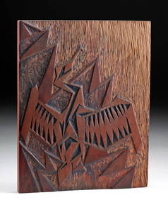
Alaskan Wood Panel Cormorant Sunning - Irma O'BrienArtemis Fine Arts4.8(1.4k)See Sold PriceFeb 26, 2024
Native American Beaded Leather Pouch w/ Game PiecesArtemis Fine Arts4.8(1.4k)See Sold PriceMar 01, 2024


![[Map] The Alaska Line. Alaska Steamship Co. (1 of 1)](https://p1.liveauctioneers.com/928/157910/79699334_1_x.jpg?height=282&quality=70&version=1577116583)