ATLAS of ANTIENT GEOGRAPHY by SAMUEL BUTLER 1843John McInnis Auctioneers,LLC4.6(502)See Sold PriceFeb 24, 2024
18TH C. ANTIQUE MAP: FRENCH & INDIAN WAR, FRAMEDThomaston Place Auction Galleries4.4(386)See Sold PriceFeb 24, 2024
Rand McNally Railroad Map Cabinet w/ 21 Railroad MapsRail & Road Auctions4.6(165)See Sold PriceMar 08, 2024
Keith Haring - Ink on New York Map, Best Buddies, Inscribed, Signed, and DatedSapphire Auction Gallery4(67)See Sold PriceMar 02, 2024
LATE 17TH C. FRENCH MAP OF THE NEW WORLD BY ALEXIS-HUBERT JAILLOT (1632-1712)Thomaston Place Auction Galleries4.4(386)See Sold PriceFeb 24, 2024
Central Railroad of New Jersey Map of Sandy Hook Route-ca. 1903JM Hobby Supply and Railroad Artifact Auctions4.4(126)See Sold PriceFeb 24, 2024
Lot of Six Mixed Atlas Box Cars-HO Scale-New in BoxJM Hobby Supply and Railroad Artifact Auctions4.4(126)See Sold PriceFeb 25, 2024
Rand McNally/Santa Fe Railroad Map of Iowa-1912JM Hobby Supply and Railroad Artifact Auctions4.4(126)See Sold PriceFeb 24, 2024
NICOLAES VISSCHER (NETHERLANDS, 1618-1709) MAP OF THE NEW WORLDThomaston Place Auction Galleries4.4(386)See Sold PriceFeb 24, 2024
17TH C. WORLD MAP BY NICOLAES VISSCHER (NETHERLANDS, 1618-1709)Thomaston Place Auction Galleries4.4(386)See Sold PriceFeb 24, 2024
Lot of Six Mixed Atlas Cabooses-HO Scale-New in BoxJM Hobby Supply and Railroad Artifact Auctions4.4(126)See Sold PriceFeb 25, 2024
Sold3 maps: 2 by Homann of regions of France, c. 1720.[Homann/Cary] 3 Maps. ++ Tabula Delphinatus Vulgo Le Gouvernment General Du Dauphine… Nurem: Johann Baptiste Homann, c. 1720s. Hand colored. 19 1/4 x 22 1/2 in. ++ Tabula Geographica Campaniae… MaSee Sold Price
1720 c. Homann Map of Northeast France, the Lorainne Region -- Lotharingiae Tabula Generalis in quaTitle: 1720 c. Homann Map of Northeast France, the Lorainne Region -- Lotharingiae Tabula Generalis in qua Ducatus Lotharingiae et Barri nec non Metensis, Tullensis et Verdunensis Episcopatus CartograSee Sold Price
1720 c. Homann Map of Northeast France, the Lorainne Region -- Lotharingiae Tabula Generalis in quaTitle: 1720 c. Homann Map of Northeast France, the Lorainne Region -- Lotharingiae Tabula Generalis in qua Ducatus Lotharingiae et Barri nec non Metensis, Tullensis et Verdunensis Episcopatus CartograSee Sold Price
1720 c. Homann Map of Northeast France, the LorainneTitle/ Content of Map: 1720 c. Homann Map of Northeast France, the Lorainne Region -- Lotharingiae Tabula Generalis in qua Ducatus Lotharingiae et Barri nec non Metensis, Tullensis et Verdunensis EpisSee Sold Price
1720 c. Homann Map of Northeast France, the LorainneTitle: 1720 c. Homann Map of Northeast France, the Lorainne Region -- Lotharingiae Tabula Generalis in qua Ducatus Lotharingiae et Barri nec non Metensis, Tullensis et Verdunensis Episcopatus CartograSee Sold Price
1720 c. Homann Map of Northeast France, the LorainneTitle/Content of Map: 1720 c. Homann Map of Northeast France, the Lorainne Region -- Lotharingiae Tabula Generalis in qua Ducatus Lotharingiae et Barri nec non Metensis, Tullensis et Verdunensis EpiscSee Sold Price
1720 c. Homann Map of Northeast France, the LorainneTitle: 1720 c. Homann Map of Northeast France, the Lorainne Region -- Lotharingiae Tabula Generalis in qua Ducatus Lotharingiae et Barri nec non Metensis, Tullensis et Verdunensis Episcopatus CartograSee Sold Price
Manuscript Map of FranceANONYMOUS, Manuscript Map. Carte des Greniers a Sels de France. Pen, ink and watercolor on paper. France, c. 1720. 24 x 32 3/4 inches sheet, 33 1/2 x 42 1/2 inches framed French Manuscript Map showingSee Sold Price
SoldBurgandy France Antique MapComitatus Burgundiae. Hand-colored engraved map. French wine region. J.B. Homann, Nuremberg, 18th C. 24 3/4" x 21".See Sold Price
Sold5 Framed maps of France and the West Indies.[Various] 5 maps. (1) Moll, Hermann. “The Island of Jamaica.” c.1720. (2) Bellin, Jacques. “Carte Des Isles Lucayes.” Paris, 1764. (3) “The Bermudas or Summer Islands.&rdSee Sold Price
Sold3 maps (Homann): Russia & Bulgaria[Homann]. Homann. 3 engraved double-page maps. Nuremberg: vd. ++ Tabula Geographia Qua Pars Russiae Magnae, Pontus Euxinus seu Mare Nigrum Tauriae Regnum. c.1720. Portion of lower left margin suppliedSee Sold Price
SoldNorth and South America by Homann c.1720Title: Totius Americae Septentrionalis et Meridionalis Novissima Repræsentatio... Author: Homann, Johann Baptiste Description: Copper-engraved map, hand-colored; 2 uncolored pictorial cartouches. 49xSee Sold Price
SoldCollection Of 3 Jaspe Tureens, 19th C.A group of 3 Jaspe tureens, 2 with lids, from the Savoie region of France, 19th C. 10" w x 9" d x 8" h.See Sold Price
2 Maps incl: Valk. PRAEFECTURA PICCARDIAE...[France/Germany] 2 Maps. ++ PRAEFECTURA PICCARDIAE, eaque partita in Comitatus Guinensem, Bononiensem, ac Ponticum, Capell, &c Praefecturum… Gerardi et Leonardi Valk. (nd). [c. 1700-1720]. Shows anSee Sold Price
Sold1720 c. Homann Map of Belgium, Northern France andTitle/Content of Map: 1720 c. Homann Map of Belgium, Northern France and Western Germany -- Arena Martis in Belgio, Qua Provinciae X. Catholicae Inferioris Germaniae Cartographer: J Homann Year/Place:See Sold Price
1720 c. Homann Map of Belgium, Northern France andTitle/Content of Map: 1720 c. Homann Map of Belgium, Northern France and Western Germany -- Arena Martis in Belgio, Qua Provinciae X. Catholicae Inferioris Germaniae Cartographer: J Homann Year/Place:See Sold Price
Sold1720 c. Homann Map of French Alps Region -- TabulaTitle/ Content of Map: 1720 c. Homann Map of French Alps Region -- Tabula Delphinatus Vulgo Gouvernement General du Dauphine in Suos Ballifiatus et Regiones Divisus per Sr. Tillemon Cartographer: J HoSee Sold Price
Homann. Domini Veneti w vicinis Parmae Mutinae MantuaHomann Erben Domini Veneti cum vicinis Parmae Mutinae, Mantua É C. 1720 Copperplate engraving; outline coloured Printed area: 58.1 x 48.7 cm; 22.9 x 19.2 in Homann Heir's map of northeastern Italy exSee Sold Price
SoldTravelling Through France, Italy in 1720-21-22Title: Some Observations Made in Travelling Through France, Italy, &c. in the Years 1720, 1721, and 1722 Author: Wright, Edward Description: 2 volumes, continuous pagination. xiii, [3], 364; [2], 365-See Sold Price
3 Maps incl: LANDGRAVIA THURINGIAE, [1753].[Homann] 3 Maps, at least 2 of them by Homann’s Heirs. Copper engraved, double-page. Images near fine. ++ DUCATUS BRUNSUICENSIS in tres suos Principatus Calenbergicum sc. Grubenhag. &c GuelpherbitanSee Sold Price
SoldPlaniglobii Terrestris Cum Utrop Hemisphere CaelestiJohann Baptist Homann. engraved map with original hand-color. Nuremberg: J.B. Homann, c. 1720. 20 1/2 x 23 inches, 31 7/8 x 34 1/2 inches Framed. Particularly Vibrant Double-Hemisphere Projection FeatSee Sold Price
SoldHomann. Totius Africae Nova Representatio. c.1720.[Africa] Homann, Johann Baptiste. “Totius Africae Nova Representatio qua Praeter diversos in ea Status et Regiones.” Nuremberg, c.1720. Engraved map. 22 1/2” x 18 7/8". Framed: 32&rdSee Sold Price
SoldColored Map of America by Johann HomannColored Map of America by Johann Homann. Printed Nurnberg c. 1720. Engraved and hand colored. 20" x 23 3/4".See Sold Price
Sold3 maps of the Netherlands. 1685-1748.[Netherlands] 3 maps. (1) Visscher II, Nicolaes. “Brabantiae Batavae Pars Orientalis.” Amsterdam, c.1685. Engraved map. 23 1/8” x 20”. (2) Homann Heirs. “Belgii UniversiSee Sold Price
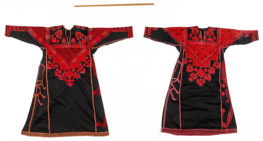
2 Traditional Syrian Woman's Dress, Saraqib Region, Early-Mid 20th C.Material Culture4.6(765)See Sold PriceFeb 29, 2024
FIONA SAUNDERS LIMOGES SHOE SHAPED BOXCharleston Estate Services Ltd.4.5(58)See Sold PriceMar 03, 2024
Lalique (France, est. 1888). "Martinets". France, c. 1970. CrystalKing's Auctions Inc4.2(121)See Sold PriceMar 03, 2024
1675 ELZEVIER JULIUS CAESAR antique ILLUSTRATED w/ MAPS ROMAN HISTORYJasper524.5(9.8k)See Sold PriceFeb 27, 2024
Medieval Sermon.- 2 leaves from a sermon on Isaiah, manuscript in Latin, on vellum, [France],Forum Auctions4.3(52)See Sold PriceFeb 29, 2024
Provence by Tiffany & Co. Sterling Silver Flatware Set 8 Service 45 piecesMynt Auctions4.6(680)See Sold PriceFeb 28, 2024
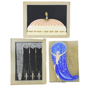
Phoebe/Costume Design/Stage Curtain Gouache 3 Pcs by Erte Original Unsigned SetMynt Auctions4.6(680)See Sold PriceMar 01, 2024
4 x Early 1900s French Impressionist Signed Flower Watercolours by Marie Carreau c. 1900'sJasper524.5(9.8k)See Sold PriceFeb 28, 2024
Lalique French frosted crystal sculpture having a swirl design titled "Moyen Modele Trophy". SignedJoshua Kodner4.2(386)See Sold PriceMar 09, 2024
Lalique French black art glass scarab vase with silver accent. Etched "Lalique (C) France" mark toJoshua Kodner4.2(386)See Sold PriceMar 09, 2024
Fine China Tea Cup w Handles & Saucer - Haviland, Burley & Co - Made in France - Pink & Blue FloralRapid Estate Liquidators and Auction Gallery4.5(1.1k)See Sold PriceMar 02, 2024


![3 Maps incl: LANDGRAVIA THURINGIAE, [1753]. (1 of 8)](https://p1.liveauctioneers.com/179/72471/37352501_1_x.jpg?height=282&quality=70&version=1432244280)


![Medieval Sermon.- 2 leaves from a sermon on Isaiah, manuscript in Latin, on vellum, [France], (1 of 1)](https://p1.liveauctioneers.com/5458/319736/171654510_1_x.jpg?height=282&quality=70&version=1708010439)