ATLAS of ANTIENT GEOGRAPHY by SAMUEL BUTLER 1843John McInnis Auctioneers,LLC4.5(505)See Sold PriceFeb 24, 2024
18TH C. ANTIQUE MAP: FRENCH & INDIAN WAR, FRAMEDThomaston Place Auction Galleries4.4(393)See Sold PriceFeb 24, 2024
Rand McNally Railroad Map Cabinet w/ 21 Railroad MapsRail & Road Auctions4.6(165)See Sold PriceMar 08, 2024
Keith Haring - Ink on New York Map, Best Buddies, Inscribed, Signed, and DatedSapphire Auction Gallery4(67)See Sold PriceMar 02, 2024
LATE 17TH C. FRENCH MAP OF THE NEW WORLD BY ALEXIS-HUBERT JAILLOT (1632-1712)Thomaston Place Auction Galleries4.4(393)See Sold PriceFeb 24, 2024
Central Railroad of New Jersey Map of Sandy Hook Route-ca. 1903JM Hobby Supply and Railroad Artifact Auctions4.4(127)See Sold PriceFeb 24, 2024
Lot of Six Mixed Atlas Box Cars-HO Scale-New in BoxJM Hobby Supply and Railroad Artifact Auctions4.4(127)See Sold PriceFeb 25, 2024
Rand McNally/Santa Fe Railroad Map of Iowa-1912JM Hobby Supply and Railroad Artifact Auctions4.4(127)See Sold PriceFeb 24, 2024
NICOLAES VISSCHER (NETHERLANDS, 1618-1709) MAP OF THE NEW WORLDThomaston Place Auction Galleries4.4(393)See Sold PriceFeb 24, 2024
17TH C. WORLD MAP BY NICOLAES VISSCHER (NETHERLANDS, 1618-1709)Thomaston Place Auction Galleries4.4(393)See Sold PriceFeb 24, 2024
Lot of Six Mixed Atlas Cabooses-HO Scale-New in BoxJM Hobby Supply and Railroad Artifact Auctions4.4(127)See Sold PriceFeb 25, 2024
SoldMatthias Seutter 1710 Map of HungaryMatthias Seutter, early map of Hungary dated 1710, 22" x 19 1/2", framed 27" x 24 1/2". Provenance: American Embassy, Vienna, Austria.See Sold Price
SoldMatthias Seutter Map of America - Novus Orbis SiveAntique Map of the Americas Hand Colored Print. Novus Orbis, Sive, America. Depicts Calif as an island.-- Dimensions: Image Size: H: 14 inches: W: 16.25 inches ---See Sold Price
SoldMatthias Seutter Map of North America(1678-1757), [Accurata delineatio celeberrimae Regionis, Ludovicianae vel Gallice Louisiane...Septemtrionali America...Mississippi vel. St. Louis...], "Matthaei Seutteri", etching with hand coloring,See Sold Price
SoldMATTHIAS SEUTTER EARLY MAP OF AMERICASEUTTER, Matthias, (German, 1678-1757): Early map of America partial title ''Novis Orbis Sive America Meridionalis et Septentrionalis,...'', hand tinted engraving, California depicted as an island, caSee Sold Price
Seutter: Antique Map Balkans, Hungary to Greece, 1740Title/Content of Map: Balkan's from Hungary to Greece Date Printed: c1740 Cartographer: Matthaus Seutter Material/Medium: Paper Size: 23 1/2" x 19 3/4" Original hand colored copperplate engraved. PublSee Sold Price
SoldSEUTTER, MATTHIAS, MAP OF NEW FRANCE, 1750Seutter, Matthias PARTIE ORIENTALE DE LA NOUVELLE FRANCE ON DU CANADA AVEC L’ISLE DE TERRE-NEUVE ET DE NOUVELLE ESCOSSE ACADIE ET NOUV-ANGLETERRE AVEC FLEUVE DE ST. LAURENCE Augsbourg, [1750] H. 59.See Sold Price
Sold1 piece. Hand-Colored Engraved Map. Seutter, Matt1 piece. Hand-Colored Engraved Map. Seutter, Matthias. Canalis Ladogenis." Augsburg, ca. 1740. 19 1/2 x 22 1/2 inches; 495 x 570 mm. Orig. color. Some foxing & discoloration, occasional dampstaining.See Sold Price
Sold1740 Matthias Seutter Colonial United States MapHistoric MapsMagnificent 1740 Matthias Seutter Colonial United States Map With "Mississippi Bubble" Investment Scheme Theme c. 1740, Hand-Colored Map entitled, "Accurata delineatio celeberSee Sold Price
Sold18th century German Map of North America by SeutterNova Orbis sive America Septentrionalis. Matthias Seutter (1678-1757). Engraved map with hand color in full. Augsburg, 1740 (State 3, 1744). 8 1/4 x 10 1/2 inches visible, 16 1/2 x 18 1/2 framed. NiceSee Sold Price
Seutter Double Hemisphere World MapDiversi Globi Terr-Aquei...Matthias Seutter (1678-1757). Engraved map with original hand color in part. Augsburg, 1735. 21 x 24 inches visible, 32 x 35 inches framed. This is one of the most graphic 1See Sold Price
SoldEarly Map of Austria and a Leaf from the NurembergEarly Map of Austria and a Leaf from the Nuremberg Chronicle, map by Matthias Seutter, titled Archiducatus Austriae Inferioris, both with hand-coloring, map 21 1/2 x 24 3/4 in.See Sold Price
Soldmap, Southern Europe, Matthias SeutterFramed hand-colored engraved map of Southern Europe, ''Theatrum Belli, Sive Novissima Tabula Qua Maxima Pars Danubii et Praeseriim Hungaria,'' by Matthias Seutter (German 1678-1757), sight: 19.25''h xSee Sold Price
SoldSeutter World MapNovus Orbis Sive America Meridionalis et Septentrionalis per sua Regna Provincias et Insulas... Matthias Seutter. Augsburg, circa 1730. Engraved map with hand color in part. 20 x 23 inches visible, 30See Sold Price
SoldRARE EARLY MAP OF NORTH AMERICA - Matthias Seutter,RARE EARLY MAP OF NORTH AMERICA - Matthias Seutter, copperplate engraving on laid paper, with later hand coloring, circa 1730; "Recens Edita Totius novi Belgii in America Septentrionali siti DelineatoSee Sold Price
Sold[Early Map of North America] 1740[Early Map of North America], Matthias Seutter, "Recens Edita Totius novi Belgii in America Septentrionali...", Augsburg, 1740, hand-colored engraved map, showing the region from Maine to Virginia, wiSee Sold Price
Sold1740 Maiestas Austriaca MapUnframed c. 1740 steel engraved & colored 20 1/4" x 24 1/2" double folio map, "Maiestas Austriaca" by Matthias Seutter, Germany, depicting central Europe showing the Archduchy of Austria & areas adjacSee Sold Price
SoldMaps, After Abraham Ortelius, After Henricus Hondius,(lot of 3) After Henricus Hondius (Dutch, 1597-1651), "Nova Virginiae Tabula," copper-engraved map with hand-coloring, After Matthias Seutter (German, 1678-1757), "Recens Edita totius Novi Belgii, inSee Sold Price
SoldSeutter Map of Eastern North America Referencing theSeutter, Matthias. Accurata delineatio celeberrimae regionis Ludovicianae vel Gallice Louisiane ol. Canadae et Floridae Adpellatione in Septemtrionali America... (Augsburg, 1730), copperplate engravinSee Sold Price
SoldMatthias Seutter (1678-1757) ''Novus Orbis Sive AmericaMatthias Seutter (1678-1757) ''Novus Orbis Sive America Meridionalis et Septentrionalis . . .'' Circa 1730 Map Engraving 20.5''x23.75'' Sheet. Very early example of this map of the Americas with handSee Sold Price
SoldRare Colonial New Ebenezer Settlement Georgia MapRare Colonial Georgia Map of the New Ebenezer Settlement [Plan Von Neu Ebenezer...] hand-colored engraving by Matthias Seutter (German, 1678-1757), for Samuel Urlsperger's Ausfuhrliche Nachtricht vonSee Sold Price
SoldMAP, Western Hemisphere, SeutterWestern Hemisphere - America. Matthias Seutter, Novus Orbis sive America Meridionalis et Septentrionalis, per sua Regna, Provincias et Insulas Iuxta Observationes et Descriptiones Recentiss. Divisa etSee Sold Price
MAP - World. SeutterWorld. Matthias Seutter, Diversi Globi Terr-Aquei Statione Variante et Visu Intercedente, per Coluros Tropicorum..., 1742 (circa). Hand Color. This is one of the most graphic 18th century world maps.See Sold Price
SoldMatthias Seutter (German 1678-1857)REGNUM HIBERNIAE, circa 1730, engraved map with original hand colouring; second state, , 57 by 50cm., 22.5 by 19.5in. Note:See Sold Price
SoldMap after Johann Homann, Asiaun-colored copperplate engraving, (Augsburg: Matthias Seutter, n.d., circa 1750), depicts the entirety of Asia. Two decorative vignettes. Presented behind mat in a gilt wooden frame. SS 19.5 x 22.75 iSee Sold Price
ACOBUS BASAGNE c1710 Theological History Numerous Engravings by De Hooghe Rare!Luis Porretta Fine Arts4.3(10)See Sold PriceMar 02, 2024
LATE 17TH C. FRENCH MAP OF THE NEW WORLD BY ALEXIS-HUBERT JAILLOT (1632-1712)Thomaston Place Auction Galleries4.4(393)See Sold PriceFeb 24, 2024
18TH C. ANTIQUE MAP: FRENCH & INDIAN WAR, FRAMEDThomaston Place Auction Galleries4.4(393)See Sold PriceFeb 24, 2024
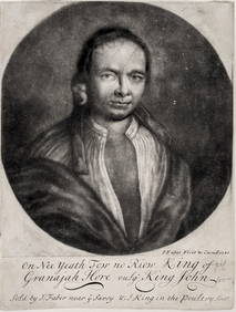
On Nee Yeath Tow No Riow. Original 1710 mezzotint by John Faber the Elder. Portrait of AmericanTremont Auctions4.5(297)See Sold PriceFeb 25, 2024
Herend Hungary blue fishnet toucan, labels on bottom, stamped Herend Hungary on bottom. Hand paintedNeely Auction4.6(224)See Sold PriceFeb 25, 2024
Keith Haring - Ink on New York Map, Best Buddies, Inscribed, Signed, and DatedSapphire Auction Gallery4(67)See Sold PriceMar 02, 2024
Rand McNally Railroad Map Cabinet w/ 21 Railroad MapsRail & Road Auctions4.6(165)See Sold PriceMar 08, 2024
18th Century Hess Germany Hand colored Engraved MapGlobal Auctions Company4.3(36)See Sold PriceMar 03, 2024
Putnam - First Map of the State of Ohio by Rufus PutnamTrillium Antique Prints & Rare Books4.5(32)See Sold PriceFeb 24, 2024
Herend Hungary Prince on Horse Trinket Lidded Box - Handpainted Porcelain Signed 7897King's Auctions Inc4.2(121)See Sold PriceMar 03, 2024


![[Early Map of North America] 1740 (1 of 2)](https://p1.liveauctioneers.com/268/130466/66335176_1_x.jpg?height=282&quality=70&version=1541096270)