ATLAS of ANTIENT GEOGRAPHY by SAMUEL BUTLER 1843John McInnis Auctioneers,LLC4.6(502)See Sold PriceFeb 24, 2024
18TH C. ANTIQUE MAP: FRENCH & INDIAN WAR, FRAMEDThomaston Place Auction Galleries4.4(386)See Sold PriceFeb 24, 2024
Rand McNally Railroad Map Cabinet w/ 21 Railroad MapsRail & Road Auctions4.6(165)See Sold PriceMar 08, 2024
Keith Haring - Ink on New York Map, Best Buddies, Inscribed, Signed, and DatedSapphire Auction Gallery4(67)See Sold PriceMar 02, 2024
LATE 17TH C. FRENCH MAP OF THE NEW WORLD BY ALEXIS-HUBERT JAILLOT (1632-1712)Thomaston Place Auction Galleries4.4(386)See Sold PriceFeb 24, 2024
Central Railroad of New Jersey Map of Sandy Hook Route-ca. 1903JM Hobby Supply and Railroad Artifact Auctions4.4(126)See Sold PriceFeb 24, 2024
Lot of Six Mixed Atlas Box Cars-HO Scale-New in BoxJM Hobby Supply and Railroad Artifact Auctions4.4(126)See Sold PriceFeb 25, 2024
Rand McNally/Santa Fe Railroad Map of Iowa-1912JM Hobby Supply and Railroad Artifact Auctions4.4(126)See Sold PriceFeb 24, 2024
NICOLAES VISSCHER (NETHERLANDS, 1618-1709) MAP OF THE NEW WORLDThomaston Place Auction Galleries4.4(386)See Sold PriceFeb 24, 2024
17TH C. WORLD MAP BY NICOLAES VISSCHER (NETHERLANDS, 1618-1709)Thomaston Place Auction Galleries4.4(386)See Sold PriceFeb 24, 2024
Lot of Six Mixed Atlas Cabooses-HO Scale-New in BoxJM Hobby Supply and Railroad Artifact Auctions4.4(126)See Sold PriceFeb 25, 2024
New Zealand North Island Navy nautical sea chartTITLE/CONTENT OF MAP: 'New Zealand - North Island East Coast - Bay of Islands' DATE PRINTED: Surveyed 1938; Published 1977; Revised to 1978 IMAGE SIZE: Approx 72.0 x 54.5cm, 28.25 x 21.5 inches (LargeSee Sold Price
New Zealand Navy nautical sea chart 1969 mapTITLE/CONTENT OF MAP: 'New Zealand North Island - West Coast - Approaches to Paremata ' DATE PRINTED: Surveyed 1965-67; Published 1969 IMAGE SIZE: Approx 72.0 x 54.5cm, 28.25 x 21.5 inches (Large) TYPSee Sold Price
Nautical Map / Sea Chart, #222 Greenwich Point to NewDescription: Nautical Map / Sea Chart, North Shore of Long Island Greenwich Pt to New Rochelle, 6th ed June 21/39 revised 11/7/60; Folded; Shipping: $20; different rate to California, Alaska, Hawaii &See Sold Price
Nautical Map / Sea Chart, #222 Greenwich Point to NewDescription: Nautical Map / Sea Chart, North Shore of Long Island Greenwich Pt to New Rochelle, 6th ed June 21/39 revised 11/7/60; Folded; Shipping: $20; different rate to California, Alaska, Hawaii &See Sold Price
Nautical Map / Sea Chart, #222 Greenwich Point to NewDescription: Nautical Map / Sea Chart, North Shore of Long Island Greenwich Pt to New Rochelle, 6th ed June 21/39 revised 11/7/60; Folded; Shipping: $20; different rate to California, Alaska, Hawaii &See Sold Price
Nautical Map / Sea Chart, #222 Greenwich Point to NewDescription: Nautical Map / Sea Chart, North Shore of Long Island Greenwich Pt to New Rochelle, 6th ed June 21/39 revised 11/7/60; Folded; Shipping: $20; different rate to California, Alaska, Hawaii &See Sold Price
Nautical Map / Sea Chart, #222 Greenwich Point to NewDescription: Nautical Map / Sea Chart, North Shore of Long Island Greenwich Pt to New Rochelle, 6th ed June 21/39 revised 11/7/60; Folded; Shipping: $20; different rate to California, Alaska, Hawaii &See Sold Price
Nautical Map / Sea Chart, #222 Greenwich Point to NewDescription: Nautical Map / Sea Chart, North Shore of Long Island Greenwich Pt to New Rochelle, 6th ed June 21/39 revised 11/7/60; Folded; Shipping: $20; different rate to California, Alaska, Hawaii &See Sold Price
Nautical Map / Sea Chart, #222 Greenwich Point to NewDescription: Nautical Map / Sea Chart, North Shore of Long Island Greenwich Pt to New Rochelle, 6th ed June 21/39 revised 11/7/60; Folded; Shipping: $20; different rate to California, Alaska, Hawaii &See Sold Price
Nautical Map / Sea Chart, #222 Greenwich Point to NewDescription: Nautical Map / Sea Chart, North Shore of Long Island Greenwich Pt to New Rochelle, 6th ed June 21/39 revised 11/7/60; Folded; Shipping: $20; different rate to California, Alaska, Hawaii &See Sold Price
1967 Nautical Map / Sea Chart #363 Shelter IslandDescription: Nautical Map / Sea Chart, United States East Coast NEW YORK - LONG ISLANDShelter Island Sound and Peconic Bays 5th Edition, February 13/ 67Correction ink stamped 14APR8 67 41" Length x 35See Sold Price
SoldNautical Map / Sea Chart, #224 Oyster & Huntington BaysUnited States East Coast, New York, Oyster & Huntington Bays, South Shore of Long Island Sound, 3rd edition feb 1/43; revised 7/21/58, note heavier bond paper and or better preserved than most; FoldedSee Sold Price
Sold(19th c) NAUTICAL CHARTS and MAPS(12) James Imray London 1881 China and Japan, Australia and New Zealand, South Part of the North Sea, Coast of North American, Ports of India 1870, Laurie Coast of China, etc. Together with approx 1See Sold Price
SoldNautical Map / Sea Chart, #1212 Eastern Long IslandDescription: Nautical Map / Sea Chart, United States East Coast, Connecticut - New York, Long Island Sound, Eastern Part, 12th edition feb 10 / 69 ; all measurements are approximate; Folded; ShippingSee Sold Price
SoldNautical Map / Sea Chart, #1211 MarthaDescription: Nautical Map / Sea Chart, United States East Coast, Rhode Island - Connecticut - New York, Block Island Sound and Approaces9th edition, dec 23/63 stamped CORRECTED ONLY FOR AIDS & HAZARDSSee Sold Price
SoldNautical Map / Sea Chart, #362 Block Island Sound andDescription: Nautical Map / Sea Chart, United States East Coast, New York, Long Island, Block Island Sound and Gardiner's Bay, 6th edition, Feb 10/69; Shipping: $20; different rate to California, AlasSee Sold Price
Nautical Map / Sea Chart, #362 Block Island Sound andDescription: Nautical Map / Sea Chart, United States East Coast New York - Long Island Block Island Sound and Gardiners Bay 2nd edition oct 15th/62 edition, stamped knutson marine center inc. mill damSee Sold Price
Nautical Map / Sea Chart, #1212 Long Island Sound -Description: Nautical Map / Sea Chart, United States East Coast, Connecticut - New York, Long Island Sound East, New London Harbor, Long Island Sound Eastern Part, 8th edition Jul/29/63 stamped w/ NOTSee Sold Price
Nautical Map / Sea Chart, #1212 Long Island Sound -Description: Nautical Map / Sea Chart, United States East Coast, Connecticut - New York, Long Island Sound East, New London Harbor, Long Island Sound Eastern Part, 8th edition Jul/29/63 stamped w/ NOTSee Sold Price
Nautical Map / Sea Chart, #1211 MarthaDescription: Nautical Map / Sea Chart, United States East Coast, Rhode Island - Connecticut - New York, Block Island Sound and Approaces9th edition, dec 23/63 stamped CORRECTED ONLY FOR AIDS & HAZARDSSee Sold Price
Nautical Map / Sea Chart, #358 FisherDesription: Nautical Map / Sea Chart, United States - East Coast Rhode Island - Connecticut - New York ; Folded; 12th edition Aug 6/62; Shipping: $20; different rate to California, Alaska, Hawaii & alSee Sold Price
Nautical Map / Sea Chart, #358 FisherDesription: Nautical Map / Sea Chart, United States - East Coast Rhode Island - Connecticut - New York ; Folded; 12th edition Aug 6/62; Shipping: $20; different rate to California, Alaska, Hawaii & alSee Sold Price
Nautical Map / Sea Chart, #362 Block Island Sound andDescription: Nautical Map / Sea Chart, United States East Coast, New York, Long Island, Block Island Sound and Gardiner's Bay, 6th edition, Feb 10/69; Shipping: $20; different rate to California, AlasSee Sold Price
Nautical Map / Sea Chart, #224 Oyster & Huntington BaysDescription: Nautical Map / Sea Chart, United States East Coast, New York Long Island, Oyster & Huntington Bays, 8th edition Dec 2/68; Folded; Shipping: $20; different rate to California, Alaska, HawaSee Sold Price
1789 Captain James Cook Life & Voyages Australia New Zealand Hawaii KippisSchilb Antiquarian Rare Books4.8(421)See Sold PriceMar 10, 2024
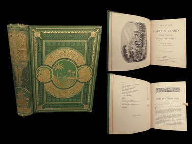
1871 Captain Cook Voyages Around the World Tahiti Hawaii Exploration AntarcticaSchilb Antiquarian Rare Books4.8(421)See Sold PriceMar 10, 2024
LATE 18TH C. VERY LARGE CHART OF NORTHEAST CANADA BY DES BARRES (1721-1824), 1780, FRAMEDThomaston Place Auction Galleries4.4(386)See Sold PriceFeb 24, 2024
LARGE EARLY 18TH C. DUTCH CHART OF UPPER NORTH AMERICA, PIERRE MORTIER (1661-1711), FRAMEDThomaston Place Auction Galleries4.4(386)See Sold PriceFeb 24, 2024
CHART "LONG ISLAND SOUND FROM NEW YORK TO MONTOCK POINT ..." New York, 1830 21" x 77" sight. FramedEldred's4.7(409)See Sold PriceFeb 27, 2024
Portfolio of 15 County Maps by Robert Morden (English 1650-1703)Nadeau's Auction Gallery4.7(401)See Sold PriceFeb 24, 2024
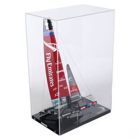
Abordage Official Emirates Team NZ Ship Desk ModelHill Auction Gallery 4.7(1k)See Sold PriceFeb 28, 2024
U.S. Navy Sea Diving Nautical Copper & Brass HelmetPassion For Antiques3.9(23)See Sold PriceFeb 24, 2024
New and Correct Map of North America With the West India Islands,Jasper524.5(9.8k)See Sold PriceFeb 27, 2024
West Indies Windward Lesser Antilles. Martinique (Belonging to France)Jasper524.5(9.8k)See Sold PriceFeb 27, 2024
South Namibia coast. Walvis Bay-Orange River ADMIRALTY sea chart 1881 (1954) mapJasper524.5(9.8k)See Sold PriceFeb 28, 2024
Large Group of Mixed Dates UK and Territories Coinage Australia New Zealand Hong KongGCB Estate Sales4.5(86)See Sold PriceMar 02, 2024