ATLAS of ANTIENT GEOGRAPHY by SAMUEL BUTLER 1843John McInnis Auctioneers,LLC4.6(502)See Sold PriceFeb 24, 2024
18TH C. ANTIQUE MAP: FRENCH & INDIAN WAR, FRAMEDThomaston Place Auction Galleries4.4(386)See Sold PriceFeb 24, 2024
Rand McNally Railroad Map Cabinet w/ 21 Railroad MapsRail & Road Auctions4.6(165)See Sold PriceMar 08, 2024
Keith Haring - Ink on New York Map, Best Buddies, Inscribed, Signed, and DatedSapphire Auction Gallery4(67)See Sold PriceMar 02, 2024
LATE 17TH C. FRENCH MAP OF THE NEW WORLD BY ALEXIS-HUBERT JAILLOT (1632-1712)Thomaston Place Auction Galleries4.4(386)See Sold PriceFeb 24, 2024
Central Railroad of New Jersey Map of Sandy Hook Route-ca. 1903JM Hobby Supply and Railroad Artifact Auctions4.4(126)See Sold PriceFeb 24, 2024
Lot of Six Mixed Atlas Box Cars-HO Scale-New in BoxJM Hobby Supply and Railroad Artifact Auctions4.4(126)See Sold PriceFeb 25, 2024
Rand McNally/Santa Fe Railroad Map of Iowa-1912JM Hobby Supply and Railroad Artifact Auctions4.4(126)See Sold PriceFeb 24, 2024
NICOLAES VISSCHER (NETHERLANDS, 1618-1709) MAP OF THE NEW WORLDThomaston Place Auction Galleries4.4(386)See Sold PriceFeb 24, 2024
17TH C. WORLD MAP BY NICOLAES VISSCHER (NETHERLANDS, 1618-1709)Thomaston Place Auction Galleries4.4(386)See Sold PriceFeb 24, 2024
Lot of Six Mixed Atlas Cabooses-HO Scale-New in BoxJM Hobby Supply and Railroad Artifact Auctions4.4(126)See Sold PriceFeb 25, 2024
Dominion of Canada (West). Ontario Quebec. 50x60cm.TITLE/CONTENT OF MAP: 'Dominion of Canada (Western Sheet)' DATE PRINTED: 1879 IMAGE SIZE: Approx 47.5 x 60.5cm, 18.5 x 23.75 inches (Large); Please note that this is a folding map. TYPE: Large, folioSee Sold Price
SoldDOMINION OF CANADA: A HANDY BOOK FOR EMIGRANTS 1880Title: Dominion of Canada: Comprising the Provinces of Prince Edward Island, Nova Scotia, New Brunswick, Quebec, Ontario, Manitoba, British Columbia, and the North-West Territories. A Handy Book for ESee Sold Price
Sold11 MAPS OF CANADA AND THE NORTH EAST UNITED STATESAll in an 18 x 14 inch binder; includes Canada West, East, Nova Scotia, Ontario, Quebec, Maine, etc.See Sold Price
SoldCollection of Mid 20th C Postcards from the UnitedCollection of Mid 20th C Postcards from the United States of: Hawaii, Washington, Alaska, Oregon, California, and The Dominion of Canada: Newfoundland, Nova Scotia, Quebec, Ontario, Manitoba, Alberto,See Sold Price
Provinces of Ontario and Quebec Dominion of CanadaTitle: Provinces of Ontario and Quebec Dominion of Canada Publication Date: 1883 Cartographer: GRAY, FRANK A. Publisher: STEDMAN & BROWN/O.W. GRAY & SON Dimension: 14.75Height - 11.8Width 158-159 fromSee Sold Price
SoldBartholomew, John 1922 Lot of 8 Maps of CanadaIncl Political, British Columbia, Alberta/Saskatchewan, Manitoba/North West Ontario, Ontario/Quebec, Maritime Provinces/Newfoundland, Western Canada, and North Eastern Canada. Large Lithograph Maps PuSee Sold Price
Bryce, James 1881 Set of 6 Maps of CanadaIncl Manitoba, British Columbia, North West Territory, Ontario, Quebec, and New Brunswick/Nova Scotia. Lithograph Maps Published 1881, London for ""The International Atlas and Geography..." by James BSee Sold Price
Bryce, James 1881 Set of 6 Maps of CanadaIncl Manitoba, British Columbia, North West Territory, Ontario, Quebec, and New Brunswick/Nova Scotia. Lithograph Maps Published 1881, London for ""The International Atlas and Geography..." by James BSee Sold Price
Bryce, James 1881 Set of 6 Maps of CanadaIncl Manitoba, British Columbia, North West Territory, Ontario, Quebec, and New Brunswick/Nova Scotia. Lithograph Maps Published 1881, London for ""The International Atlas and Geography..." by James BSee Sold Price
SoldTWO NINETEENTH CENTURY MAPS OF CANADA, one CountyTWO NINETEENTH CENTURY MAPS OF CANADA, one County map of Canada West (primarily Ontario), one County map of Canada East (primarily Quebec); hand colored engravings. Well matted and framed. Measuring 1See Sold Price
Map of West Canada by John Talis & CoMap: West Canada Maker: John Tallis & Company, J. Rapkin Size: Quarto - 8.5 inches high x 11.75 inches wide Actually southern Ontario and Quebec. Vignettes by H. Warren show Indians, Kingston, ProvincSee Sold Price
Sold17 1800's/1900's book plate maps17 1800's/1900's book plate maps including Arkansas Mississippi and Louisiana; Arizona; South Carolina; Ontario; Dominion of Canada; Mexico Central America and West Indies; West Virginia. Most are RanSee Sold Price
SoldJAMES BARNSLEY (1861-1929, Canada) ImpressionistSeascape. Harbor scene. Possibly France or Haiti, where the artists spent time. Oil on canvas laid on board. 20 x 14 in. Born in West Flamboro, Ontario in 1861. Died in Verdun, Quebec in 1929. BarnsleSee Sold Price
SoldCanadian CDV of Man in Buckskins, Possibly MetisAlbumen CDV by Smith & Son, Brantford C.W. (Canada West, now Ontario). A curious CDV of a man in extraordinary dress. Full-length studio portrait of a confidently posed man with European features, weaSee Sold Price
GREAT LAKES & SOUTHERN ONTARIO. Lakes Huron, Erie &TITLE/CONTENT OF MAP: 'NORTH AMERICA, SHEET III., The Dominion of Canada. Ontario with parts of New York, Pennsylvania and Michigan' This map is folding hence the centrefold line may show on the imageSee Sold Price
GREAT LAKES & SOUTHERN ONTARIO. Lakes Huron, Erie &TITLE/CONTENT OF MAP: 'NORTH AMERICA, SHEET III., The Dominion of Canada. Ontario with parts of New York, Pennsylvania and Michigan' The top image on the right hand side shows the entire map. To viewSee Sold Price
1850 Tallis map of Ontario, Canada -- West CanadaTitle/Content of Map: 1850 Tallis map of Ontario, Canada -- West Canada Date: 1850, London Cartographer: J Tallis Size: 10 X 13 in. A very nice map of today's Ontario surrounded in a decorative borderSee Sold Price
SoldMeyer: Upper Canada (Ontario) / Lower Canada (Quebec)Cartographer: Bibliographischen Instituts. Place / Date: Hildburghausen / 1849/1857 Size: 14 5/8" x 11 3/4"Condition: original color; overall age toning, minor browning along margin edges The beautifuSee Sold Price
Sold1850 Tallis Map of Ontario, Canada -- West CanadaTitle/Content of Map: 1850 Tallis Map of Ontario, Canada -- West Canada Date: 1850, London Cartographer: J Tallis Size: 10 X 13 in. A very nice map of today's Ontario surrounded in a decorative borderSee Sold Price
1850 Tallis Map of Ontario, Canada -- West CanadaTitle/Content of Map: 1850 Tallis Map of Ontario, Canada -- West Canada Date: 1850, London Cartographer: J Tallis Size: 10 X 13 in. A very nice map of today's Ontario surrounded in a decorative borderSee Sold Price
SoldMeyer: Upper Canada (Ontario) / Lower Canada (Quebec)Map Title: Ober (Upper) Canada 1849 / Unter (Lower) Canada 1849 Cartographer: Bibliographischen Instituts. Place/Date: Hildburghausen / 1849/1857 Size: 14 5/8" x 11 3/4" Condition: original outline coSee Sold Price
Meyer: Upper Canada (Ontario) / Lower Canada (Quebec)Map Title: Ober (Upper) Canada 1849 / Unter (Lower) Canada 1849Cartographer: Bibliographischen Instituts. Place/Date: Hildburghausen / 1849/1857 Size: 14 5/8" x 11 3/4" Condition: original color; overSee Sold Price
1850 Tallis Map of Ontario, Canada -- West CanadaTitle/Content of Map: 1850 Tallis Map of Ontario, Canada -- West Canada Date: 1850, London Cartographer: J Tallis Size: 10 X 13 in. A very nice map of today's Ontario surrounded in a decorative borderSee Sold Price
1850 Tallis Map of Ontario, Canada -- West CanadaTitle/Content of Map: 1850 Tallis Map of Ontario, Canada -- West Canada Date: 1850, London Cartographer: J Tallis Size: 10 X 13 in. A very nice map of today's Ontario surrounded in a decorative borderSee Sold Price
RED INDIAN GASOLINE SINGLE 13.5" GLOBE LENS ON NARROW MILK GLASS BODY.Dan Morphy Auctions4.2(1.3k)See Sold PriceFeb 24, 2024
FRANK MARMINGTON c1910 National Gallery Canada Signed Engraving London St. Pauls 20" x 16"Luis Porretta Fine Arts4.3(10)See Sold PriceMar 02, 2024
MATTHEWS c1856 Map Of Upper Canada Ontario Indian Land Agency Divisions Scarce!Luis Porretta Fine Arts4.3(10)See Sold PriceMar 02, 2024
DUNLEVIE c1856 Map Counties Of Gaspe & Bonaventure Quebec Canada SCARCE! #1Luis Porretta Fine Arts4.3(10)See Sold PriceMar 02, 2024
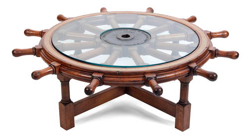
SHIPíS WHEEL MOUNTED AS A LOW TABLE Late 19th Century Wheel diameter 54.5". Height as tableEldred's4.7(409)See Sold PriceFeb 28, 2024
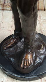
Sign American Indian Chief Warrior Bronze Statue Figure sculptureHouse of Treasure4.4(50)See Sold PriceFeb 29, 2024
Dow Beer 1920s Canadian Porcelain Enamel Serving TrayMorean Auctions4.5(31)See Sold PriceFeb 25, 2024
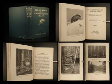
1912 HUNTING Alaska Vancouver Sheldon Wilderness of North Pacific Canada BearSchilb Antiquarian Rare BooksSee Sold PriceMar 31, 2024
[BASEBALL]. Group of 10 Real Photo Postcards of Collegiate ...Potter & Potter Auctions4.6(539)See Sold PriceMar 07, 2024
Robert Bateman "Edge of Night - Timber Wolves" Signed Litho w/COAMichael's Gallery4.6(89)See Sold PriceFeb 24, 2024
Sylvania Electronic Radio Tubes Lighted ClockMiller & Miller Auctions Ltd.4.7(316)See Sold PriceMar 02, 2024
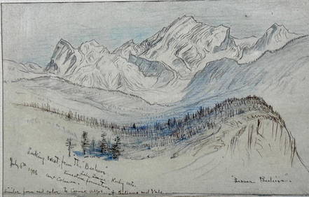
Samuel Colman Drawing, "Lesser Beehive," Lake Louise, Alberta, CanadaNeue Auctions4.6(353)See Sold PriceMar 02, 2024
Iroquois Cornhusk Doll Wearing False Face Society MaskArtemis Fine Arts4.8(1.4k)See Sold PriceFeb 26, 2024
Five boxed 1:144 scale limited edition die-cast models of passenger and commercial airliners by ...Bonhams4.1(305)See Sold PriceMar 01, 2024
Robert de Vaugondy - Map of Canada - Mer de l' Ouest or Sea of the West and a Northwest PassageProverde Auctions4.3(3)See Sold PriceFeb 28, 2024


![[BASEBALL]. Group of 10 Real Photo Postcards of Collegiate ... (1 of 2)](https://p1.liveauctioneers.com/928/318880/171361370_1_x.jpg?height=282&quality=70&version=1707501302)