ATLAS of ANTIENT GEOGRAPHY by SAMUEL BUTLER 1843John McInnis Auctioneers,LLC4.6(502)See Sold PriceFeb 24, 2024
18TH C. ANTIQUE MAP: FRENCH & INDIAN WAR, FRAMEDThomaston Place Auction Galleries4.4(386)See Sold PriceFeb 24, 2024
Rand McNally Railroad Map Cabinet w/ 21 Railroad MapsRail & Road Auctions4.6(165)See Sold PriceMar 08, 2024
Keith Haring - Ink on New York Map, Best Buddies, Inscribed, Signed, and DatedSapphire Auction Gallery4(67)See Sold PriceMar 02, 2024
LATE 17TH C. FRENCH MAP OF THE NEW WORLD BY ALEXIS-HUBERT JAILLOT (1632-1712)Thomaston Place Auction Galleries4.4(386)See Sold PriceFeb 24, 2024
Central Railroad of New Jersey Map of Sandy Hook Route-ca. 1903JM Hobby Supply and Railroad Artifact Auctions4.4(126)See Sold PriceFeb 24, 2024
Lot of Six Mixed Atlas Box Cars-HO Scale-New in BoxJM Hobby Supply and Railroad Artifact Auctions4.4(126)See Sold PriceFeb 25, 2024
Rand McNally/Santa Fe Railroad Map of Iowa-1912JM Hobby Supply and Railroad Artifact Auctions4.4(126)See Sold PriceFeb 24, 2024
NICOLAES VISSCHER (NETHERLANDS, 1618-1709) MAP OF THE NEW WORLDThomaston Place Auction Galleries4.4(386)See Sold PriceFeb 24, 2024
17TH C. WORLD MAP BY NICOLAES VISSCHER (NETHERLANDS, 1618-1709)Thomaston Place Auction Galleries4.4(386)See Sold PriceFeb 24, 2024
Lot of Six Mixed Atlas Cabooses-HO Scale-New in BoxJM Hobby Supply and Railroad Artifact Auctions4.4(126)See Sold PriceFeb 25, 2024
Lotter: Antique Map of Silesia, 1770Title/Content of Map: Nova Mappa Geograph. Totius Silesiae..." Date Printed: 1770 Cartographer: LOTTER, TOBIAS CONRAD Size (inches): 7.6x10 From Lotter's Atlas Minor. Shows also region of Saxony, BoheSee Sold Price
Lotter: Antique Map of Balearic Islands, Spain, 1770Title/Content of Map: Carte des Isles de Maiorque, Minorque et d'Yvice Cartographer: Lotter Place & Date: Augsburg / 1770 Size: 22" x 18 1/4" Condition: old color (cartouche in b&w) overall age toningSee Sold Price
SoldLotter: Antique Map of Greece & Aegean Islands, 1770Map: Graecia Nova et Mare Aegeum Cartographer: Conrad Lotter Place & Date: Augsburg / 1770 (circa) Size: 22 3/4" x 19 3/4" Condition: repair at lower end of fold with minor loss at the bottom center bSee Sold Price
SoldMAP "AMERICAN SEPTENTRIONALIS JUXTA OBSERVATIONESDNN A CAMEDIOE REGALIS SCIENTARIUM ET NUNNULBRUM A LIORUME AND JUXTA ANNOTATIONES RECENTISSIMAS" BY TOBIAS CONRAD LOTTER, 1770. SIGHT SIZE 18 1/2" X 24 1/2", OVERALL 28" X 33 1/2". NEW FRAME, MAT ANDSee Sold Price
Lotter: Antique Map of Sicily and Malta, 1760Title/Content of Map: Mappa Geographica totius Insulae et Regni Siciliae Cartographer: Lotter Place & Date: Augsburg / 1760 Size: 22" x 19 1/2" Condition: wash color, cartouches in b&w; overall age toSee Sold Price
SoldLotter: Antique Map of Africa, 1772Title/Content of Map: Africa by Lotter Date Printed: 1772 Cartographer: G.C. Lotter Material/Medium: Paper Size: 23" x 18" Hand colored copperplate engraved. Published in Augsburg Germany. Please noteSee Sold Price
SoldTobias Lotter Antique Framed MapTobias Lotter antique map. Measures 7.75" x 10" plate size and approximately 8.5" x 11" sheet size. Good condition, taped to mat verso. We ship most items in this auction in house and gladly combine sSee Sold Price
SoldNORTH AMERICA COLORED MAP, C. 1763, POSTLETHWAYTFramed antique map c. 1770, "North America, Plate 1" from the publication "Dictionary of Trade and Commerce" by Malachy Postlethwayt (British, 1707-1767), hand colored, also reading "North America, PeSee Sold Price
SoldNORTH AMERICA COLORED MAP, C. 1763, POSTLETHWAYTFramed antique map c. 1770, "North America, Plate III" and "Part of North America, Plate IV", from the publication "Dictionary of Trade and Commerce" by Malachy Postlethwayt (British, 1707-1767), handSee Sold Price
SoldZatta: Antique Map of Africa, 1770Title/Content of Map: Africa by Zatta Date Printed: 1770 Cartographer: Antonio Zatta Material/Medium: Paper Size: 17" x 13" Published in Venice. Hand colored. Copperplate engraved. Antonio Zatta (1722See Sold Price
Bowen: Antique Map of Brazil, 1770Map: A New & Accurate Map of Brasil. Publication Date: 1770 ca. Authors: E. BOWEN, BOWEN, EMANUEL Publisher: E. BOWEN Size: Folio – 13.75 H x 16.75 W Inches "Divided into its Captainships drawn fromSee Sold Price
Antique Map of Upper Silesia - Grodkow and Nysa - Poland - Europe - JanssoniusAttractive old coloured engraved map of Upper Silesia from J. Scultetus by J. Janssonius. Showing the area around Nysa and Grodkow. With three beautiful coloured cartouches. Johannes Janssonius also kSee Sold Price
SoldMap, Ducatus Silesiae Grotganus, J JanssoniusAn antique map of Upper Silesia, showing the area around Nysa and Grodkow. 17th century. Titled Ducatus Silesiae Grotganus cum Districtu Episcopali Nissensi Delineatore Iona Sculteto, Silesio. CartogrSee Sold Price
SoldBellin: Antique Map of Hudson Bay, 1770Map: Hudson Bay Date Printed: 1770 Cartographer: N. Bellin Material/Medium: Paper Size: 12 3/4" x 9 1/2" Rare Map. Printed in Paris. From the Atlas Portrait Jacques-Nicolas Bellin(1703-1772) was a FreSee Sold Price
SoldRapin-Thoyras: Antique Map of British Atlantic, 1770Map: Carte Generale des Royaumes, Etats & Domaines, que les Rois & la Couronne de la Grande-Bretagne ont Possedez ou Possedent en Europe en Afrique & en Amerique Cartographer: Rapin de Thoyras Place &See Sold Price
Lotter Map of N. America, 1770After DE L'ISLE, Guillaume (1675-1726). America Septentrionalis, Concinnata juxta Observationes... Engraved map with original hand color. Augsburg: Lotter, Ca. 1770. 21 1/8" x 24 1/2" sheet. This mapSee Sold Price
Seutter: Antique Map of Lower Austria, 1770Title/Content of Map: Archiducatus Austriae Inferioris ..." Date Printed: 1770 ca. Cartographer: SEUTTER, ALBRECHT KARL (1722-1762) Size (inches): 8.3x13.8 Detailed small atlas map of lower Austria shSee Sold Price
Antique Map of Bohemia, Moravia, Silesia, Lussatia 1756Title/Content of Map: Map of Bohemia, Moravia, Silesia, Lussatia, With Great Part of Saxony and Brandenburg; Shewing the Present Seat Of War, in Germany Date Printed: 1756-12-01 Cartographer: ANONYMOUSee Sold Price
SoldLodge: Antique Map of Turkey in Europe, 1770Map: A New and Accurate Map of Turkey in Europe, Publication Date: 1770 Authors: D. HENRY/F. NEWBERY, LODGE, J. Publisher: D. HENRY/F. NEWBERY Size: Quarto – 8.75 H x 10.00 W Inches drawn fromSee Sold Price
Antique Map Print - Europe - Map of Silesia - Poland - Czech Republic - WroclawTitle/Artist: Antique Map Print - Europe - Map of Silesia - Poland - Czech Republic - Wroclaw Date/Period: 17th Century Material: Paper Dimensions: 20 cm x 13 cm Description: Map of Silesia. Silesia iSee Sold Price
Antique Map Print - Europe - Map of Silesia - Poland - John Cary - 1816Title/Artist: Antique Map Print - Europe - Map of Silesia - Poland - John Cary - 1816 Date/Period: 1816 Material: Paper Dimensions: 36 cm x 29 cm Description: An excellent detailed regional map of SilSee Sold Price
Antique Map Print - Europe - Map of Silesia - Czech Republic - Wroclaw - PolandTitle/Artist: Antique Map Print - Europe - Map of Silesia - Czech Republic - Wroclaw - Poland Date/Period: 17th Century Material: Paper Dimensions: 18 cm x 12 cm Description: Map of Silesia. Silesia iSee Sold Price
Bellin: Antique Map of Greenland and Iceland, 1770Carte du Groenland A beautifully engraved (and preserved) map of Greenland and Iceland, from Prevost d'Exiles' influential collection of travel narratives, Histoire Generale des Voyages. The map encomSee Sold Price
de Thoyras: Antique Map of British Crown Domains, 1770Map: Carte Generale des Royaumes, Etats & Domaines, que les Rois & la Couronne de la Grande-Bretagne ont Possedez ou Possedent en Europe en Afrique & en Amerique Cartographer: Rapin de Thoyras Place &See Sold Price
17TH C. ANTIQUE MAP SIEGE OF LA ROCHELLE, FRANCE, FRAMEDThomaston Place Auction Galleries4.4(386)See Sold PriceFeb 24, 2024
18TH C. ANTIQUE MAP: FRENCH & INDIAN WAR, FRAMEDThomaston Place Auction Galleries4.4(386)See Sold PriceFeb 24, 2024
Framed Hand Colored Antique Map of the Department of Nord, FranceDonny Malone Auctions4.5(1.7k)See Sold PriceMar 04, 2024
1736 LARGE MAP OF SILESIA POLAND OPPAVIENSIS antique 25 by 34 3/4"Jasper524.5(9.8k)See Sold PriceFeb 27, 2024
1736 LARGE MAP OF SILESIA POLAND KARNOVIENSIS antique 25 x 4 3/4" Duchy of KrnovJasper524.5(9.8k)See Sold PriceFeb 27, 2024
AFRICA. Pre 'Scramble for Africa'. BARTHOLOMEW 1876 old antique map plan chartJasper524.5(9.8k)See Sold PriceFeb 28, 2024
Cooke, George 1801 Antique Map. United States of AmericaAlbion Auctions4.6(336)See Sold PriceMar 01, 2024
Cooke, George 1801 Antique Map. Italy, Sicily, Sardinia & CorsicaAlbion Auctions4.6(336)See Sold PriceMar 01, 2024
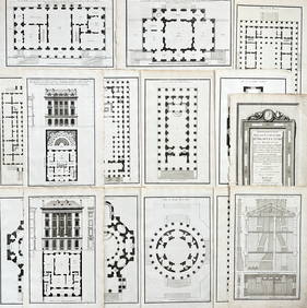
Jean-Francois de Neufforge (1714 - 1791) - Set of 15 Architecture Prints - Development pour unProverde Auctions4.3(3)See Sold PriceFeb 28, 2024
Jean-Francois de Neufforge (1714 - 1791) - Set of 15 Architecture Prints - Plan de l' EdificeProverde Auctions4.3(3)See Sold PriceFeb 28, 2024
Francis McNally - Antique Map of Ohio, Indiana & KentuckyProverde Auctions4.3(3)See Sold PriceFeb 28, 2024
Francis McNally - Antique Map of Washington, Oregon, Idaho, Nevada, Utah & ArizonaProverde Auctions4.3(3)See Sold PriceFeb 28, 2024
Historic Map - The Duchy of Silesia, Poland, Wilkinson, 1792.Proverde Auctions4.3(3)See Sold PriceFeb 28, 2024
Antique Map of Poland, 1700 by Guillaume De Lisle, ParisAntiques Online Auctions4.6(407)See Sold PriceMar 14, 2024