ATLAS of ANTIENT GEOGRAPHY by SAMUEL BUTLER 1843John McInnis Auctioneers,LLC4.6(504)See Sold PriceFeb 24, 2024
18TH C. ANTIQUE MAP: FRENCH & INDIAN WAR, FRAMEDThomaston Place Auction Galleries4.4(389)See Sold PriceFeb 24, 2024
Rand McNally Railroad Map Cabinet w/ 21 Railroad MapsRail & Road Auctions4.6(165)See Sold PriceMar 08, 2024
Keith Haring - Ink on New York Map, Best Buddies, Inscribed, Signed, and DatedSapphire Auction Gallery4.1(67)See Sold PriceMar 02, 2024
LATE 17TH C. FRENCH MAP OF THE NEW WORLD BY ALEXIS-HUBERT JAILLOT (1632-1712)Thomaston Place Auction Galleries4.4(389)See Sold PriceFeb 24, 2024
Central Railroad of New Jersey Map of Sandy Hook Route-ca. 1903JM Hobby Supply and Railroad Artifact Auctions4.4(126)See Sold PriceFeb 24, 2024
Lot of Six Mixed Atlas Box Cars-HO Scale-New in BoxJM Hobby Supply and Railroad Artifact Auctions4.4(126)See Sold PriceFeb 25, 2024
Rand McNally/Santa Fe Railroad Map of Iowa-1912JM Hobby Supply and Railroad Artifact Auctions4.4(126)See Sold PriceFeb 24, 2024
NICOLAES VISSCHER (NETHERLANDS, 1618-1709) MAP OF THE NEW WORLDThomaston Place Auction Galleries4.4(389)See Sold PriceFeb 24, 2024
17TH C. WORLD MAP BY NICOLAES VISSCHER (NETHERLANDS, 1618-1709)Thomaston Place Auction Galleries4.4(389)See Sold PriceFeb 24, 2024
Lot of Six Mixed Atlas Cabooses-HO Scale-New in BoxJM Hobby Supply and Railroad Artifact Auctions4.4(126)See Sold PriceFeb 25, 2024
"Carte d'Assemblage de l'Europe. VANDERMAELEN 1827 oldTITLE/CONTENT OF MAP: 'Carte d'Assemblage de l'Europe' DATE PRINTED: 1827 IMAGE SIZE: Approx 71.0 x 52.0cm, 27.75 x 20.25 inches (Large); Please note that this is a folding map. TYPE: Antique folio-siSee Sold Price
"Carte d'Assemblage de l'Europe. VANDERMAELEN 1827 oldTITLE/CONTENT OF MAP: 'Carte d'Assemblage de l'Europe' DATE PRINTED: 1827 IMAGE SIZE: Approx 71.0 x 52.0cm, 27.75 x 20.25 inches (Large); Please note that this is a folding map. TYPE: Antique folio-siSee Sold Price
Carte d'Assemblage de l'Europe. VANDERMAELEN 1827 old antique map planTITLE/CONTENT OF MAP: 'Carte d'Assemblage de l'Europe' DATE PRINTED: 1827 IMAGE SIZE: Approx 71.0 x 52.0cm, 27.75 x 20.25 inches (Large); Please note that this is a folding map. TYPE: Antique folio-siSee Sold Price
"Carte d'Assemblage de l'Europe. VANDERMAELEN 1827 oldTITLE/CONTENT OF MAP: 'Carte d'Assemblage de l'Europe' Date: 1827 IMAGE SIZE: Approx 71.0 x 52.0cm, 27.75 x 20.25 inches (Large); Please note that this is a folding map. TYPE: Antique folio-sized lithSee Sold Price
"Carte d'Assemblage de l'Europe. VANDERMAELEN 1827 oldTitle/Content of Map: 'Carte d'Assemblage de l'Europe' Date Printed: 1827 Image Size: Approx 71.0 x 52.0cm, 27.75 x 20.25 inches (Large); Please note that this is a folding map. Type: Antique folio-siSee Sold Price
Carte d'Assemblage de l'Europe. VANDERMAELEN 1827 old antique map plan chart TITLE/CONTENT OF MAP:Reserve: $114.00 Shipping: Domestic: Flat-rate of $30.00 to anywhere within the contiguous U.S. International: Foreign shipping rates are determined by destination. International shipping may be subjeSee Sold Price
Carte d'Assemblage de l'Europe. Index map. VANDERMAELEN 1827 old antiqueTITLE/CONTENT OF MAP: 'Carte d'Assemblage de l'Europe' DATE PRINTED: 1827 IMAGE SIZE: Approx 50.0 x 68.0cm, 19.75 x 26.75 inches (Large) TYPE: Antique folio-sized lithographic atlas map, hand colouredSee Sold Price
Carte d'Assemblage de l'Europe. Index map. VANDERMAELEN 1827 old antiqueTITLE/CONTENT OF MAP: 'III. Carte d'Alemagne, comprenant les Cercles de Baviére, d'Autriche et de Souabe avec La Suisee' DATE PRINTED: 1777 IMAGE SIZE: Approx 18.5 x 16.5cm, 7.25 x 6.25 inches (MSee Sold Price
Vandermaelen: Antique Map of Europe, 1827TITLE/CONTENT OF MAP: 'Carte d'Assemblage de l'Europe' DATE PRINTED: 1827 IMAGE SIZE: Approx 71.0 x 52.0cm, 27.75 x 20.25 inches (Large); Please note that this is a folding map. TYPE: Antique folio-siSee Sold Price
EUROPE 1940. WW2. Belligerents/Neutrals Occupied Poland/Finland Albania 1940 mapTITLE/CONTENT OF MAP: 'Carte d'Assemblage de l'Europe' DATE PRINTED: 1827 IMAGE SIZE: Approx 50.0 x 68.0cm, 19.75 x 26.75 inches (Large) TYPE: Antique folio-sized lithographic atlas map, hand colouredSee Sold Price
Carte d'Assemblage de l'Asie. Asia & Middle East index map VANDERMAELEN 1827TITLE/CONTENT OF MAP: 'Carte d'Assemblage de l'Asie' Index map of Asia and the Middle East DATE PRINTED: 1827 IMAGE SIZE: Approx 47.5 x 66.0cm, 18.75 x 26 inches (Large) TYPE: Antique folio-sized lithSee Sold Price
Carte d'Assemblage de l'Asie. Asia & Middle East index map VANDERMAELEN 1827TITLE/CONTENT OF MAP: 'Carte d'Assemblage de l'Asie' Index map of Asia and the Middle East DATE PRINTED: 1827 IMAGE SIZE: Approx 47.5 x 66.0cm, 18.75 x 26 inches (Large) TYPE: Antique folio-sized lithSee Sold Price
Vandermaelen's Key Map to North America 1825Title: Carte d'Assemblage de l'Amerique Septentrionale Author: Vandermaelen, Phillipe Marie Guillaume Description: Lithographed map. 45x61.5 cm. (17½x24¼") plus title at top.The important key map toSee Sold Price
Carte de L'Europe. Map of Europe. MALTE-BRUN c1871 oldTITLE/CONTENT OF MAP: 'Carte de l'Europe [Map of Europe]' DATE PRINTED: c1871 IMAGE SIZE: Approx 33.5 x 46.5cm, 13.25 x 18.25 inches (Large); Please note that this is a folding map. TYPE: Antique 19thSee Sold Price
Carte de L'Europe. Map of Europe. MALTE-BRUN c1871 old antique plan chartTITLE/CONTENT OF MAP: 'Carte de l'Europe [Map of Europe]' DATE PRINTED: c1871 IMAGE SIZE: Approx 33.5 x 46.5cm, 13.25 x 18.25 inches (Large); Please note that this is a folding map. TYPE: Antique 19thSee Sold Price
Carte de L'Europe. Map of Europe. MALTE-BRUN c1871 old antique plan chartTITLE/CONTENT OF MAP: 'Scandinavia, or Sweden, Denmark and Norway' DATE PRINTED: 1830 IMAGE SIZE: Approx 60.5 x 51.0cm, 23.75 x 20 inches (Large); Please note that this is a folding map. TYPE: AntiqueSee Sold Price
Atlante - Vandermaelen, PhilippeStatistique de L'Europe, d'apres Hassel Bruxelles, Vandermaelen, 1827. In 2°. Testo inquadrato da cornice di duplice filetto, tavola a doppia pagina della "Carta delle distanze". Segue Atlas UniverseSee Sold Price
Carte D'assemblage De L'amerique Septenle.Title/Content of Map: Carte D'assemblage De L'amerique Septenle. Date Printed: 1825 Cartographer: VANDERMAELEN, PHILIPPE M. G. Size: 19.25X24 Few small mildew stains.Key to his maps of North America.See Sold Price
Carte D'assemblage De L'amerique Septenle.Title/Content of Map: Carte D'assemblage De L'amerique Septenle. Date Printed: 1825 Cartographer: VANDERMAELEN, PHILIPPE M. G. Size (inches): 8.3x14.5 Key to his maps of North America. From the firstSee Sold Price
Carte D'assemblage De L'amerique Septenle.Reserve Reduced! Title: Carte D'assemblage De L'amerique Septenle. Publication Date: 1825 Cartographer: VANDERMAELEN, PHILIPPE M. G. Publisher: VANDERMAELEN Size: 19.25 x 24 Key to his maps of North ASee Sold Price
Asie. Partie de l'Arabie #92 Oman & SE Saudi Arabia VANDERMAELEN 1827 old mapTitle: Asie. Partie de l'Arabie #92 Oman & SE Saudi Arabia VANDERMAELEN 1827 old map Description: Asie - Partie de l'Arabie - No. 92' by Philippe Marie Guillaume Vandermaelen. Lithography by Henri OdeSee Sold Price
FRANCE. 'Carte Generale'. Towns, rivers & provinces. MALLET 1683 old mapTITLE OF THE MAP: 'Carte Generale de France' (De L'Europe) DATE PRINTED: 1683 IMAGE SIZE: Approx Overall page size 26 x 21cm approximately (10 x 8 inches); image size 21 x 14.5cm approximately (8 x 5.See Sold Price
MAP, Central Europe, ChatelainCentral Europe, Austria. Henry Abraham Chatelain, Carte de l'Etat de la Cour Imperiale et des Etats Hereditaires de la Maison d'Autriche avec Leurs Diverses Chanceleries, 1720 (circa). Black & White.See Sold Price
Vandermaelen: Antique Map of Northern Italy, 1827TITLE/CONTENT OF MAP: 'Europe - Partie de l'Italie - No 20 ' Most of the northern Italian states, Switzerland, the western Balkans, and the southern part of what is now Austria DATE PRINTED: 1827 IMAGSee Sold Price
Railways & Transport.- [Prospectus] The Dorking, Brighton, and Arundel Atmospheric Railway, byForum Auctions4.3(53)See Sold PriceFeb 29, 2024
Carte de l'Afrique propre, de la Numidie… North Africa. LAPIE 1829 old mapJasper524.5(9.8k)See Sold PriceFeb 28, 2024
NICOLAS LEMERY'S 1717 PHARMACOPEIA IS AN OLD FRENCH PHARMACOLOGY TREATISE FROM THE 17TH CENTURY.NY Elizabeth 4.3(85)See Sold PriceMar 03, 2024
DORE GUSTAVE: (1832-1883)International Autograph Auctions Europe S.L.4.5(52)See Sold PriceMar 14, 2024
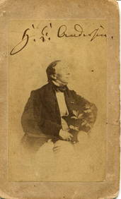
ANDERSEN HANS CHRISTIAN: (1805-1875)International Autograph Auctions Europe S.L.4.5(52)See Sold PriceMar 14, 2024
MARGARET OF PARMA: (1522-1586)International Autograph Auctions Europe S.L.4.5(52)See Sold PriceMar 14, 2024
WILHELM KARL: (1864-1928)International Autograph Auctions Europe S.L.4.5(52)See Sold PriceMar 14, 2024
[ALEXANDER III]: (1845-1894)International Autograph Auctions Europe S.L.4.5(52)See Sold PriceMar 14, 2024


![Railways & Transport.- [Prospectus] The Dorking, Brighton, and Arundel Atmospheric Railway, by (1 of 1)](https://p1.liveauctioneers.com/5458/319736/171654703_1_x.jpg?height=282&quality=70&version=1708010439)


![[ALEXANDER III]: (1845-1894) (1 of 2)](https://p1.liveauctioneers.com/1458/320148/172030958_1_x.jpg?height=282&quality=70&version=1708367366)


