ATLAS of ANTIENT GEOGRAPHY by SAMUEL BUTLER 1843John McInnis Auctioneers,LLC4.5(505)See Sold PriceFeb 24, 2024
18TH C. ANTIQUE MAP: FRENCH & INDIAN WAR, FRAMEDThomaston Place Auction Galleries4.4(393)See Sold PriceFeb 24, 2024
Rand McNally Railroad Map Cabinet w/ 21 Railroad MapsRail & Road Auctions4.6(165)See Sold PriceMar 08, 2024
Keith Haring - Ink on New York Map, Best Buddies, Inscribed, Signed, and DatedSapphire Auction Gallery4(67)See Sold PriceMar 02, 2024
LATE 17TH C. FRENCH MAP OF THE NEW WORLD BY ALEXIS-HUBERT JAILLOT (1632-1712)Thomaston Place Auction Galleries4.4(393)See Sold PriceFeb 24, 2024
Central Railroad of New Jersey Map of Sandy Hook Route-ca. 1903JM Hobby Supply and Railroad Artifact Auctions4.4(127)See Sold PriceFeb 24, 2024
Lot of Six Mixed Atlas Box Cars-HO Scale-New in BoxJM Hobby Supply and Railroad Artifact Auctions4.4(127)See Sold PriceFeb 25, 2024
Rand McNally/Santa Fe Railroad Map of Iowa-1912JM Hobby Supply and Railroad Artifact Auctions4.4(127)See Sold PriceFeb 24, 2024
NICOLAES VISSCHER (NETHERLANDS, 1618-1709) MAP OF THE NEW WORLDThomaston Place Auction Galleries4.4(393)See Sold PriceFeb 24, 2024
17TH C. WORLD MAP BY NICOLAES VISSCHER (NETHERLANDS, 1618-1709)Thomaston Place Auction Galleries4.4(393)See Sold PriceFeb 24, 2024
Lot of Six Mixed Atlas Cabooses-HO Scale-New in BoxJM Hobby Supply and Railroad Artifact Auctions4.4(127)See Sold PriceFeb 25, 2024
1784 Cadell Antique Map of the Caspian Sea RegionTitle/Content of Map: 1784 Cadell Map of the Caspian Sea Region -- Chart of the Caspian Sea Date Printed: 1784, London Cartographer: T Cadell Size: 7.5 x 6.3 in. A very nice map of the then recently eSee Sold Price
Cadell: Antique Map of the Caspian Sea Region, 1784Title/Content of Map: 1784 Cadell Map of the Caspian Sea Region -- Chart of the Caspian Sea Date Printed: 1784, London Cartographer: T Cadell Size: 7.5 x 6.3 in. A very nice map of the then recently eSee Sold Price
Sold1784 Cadell Map of the Caspian Sea Region -- Chart ofTitle/Content of Map: 1784 Cadell Map of the Caspian Sea Region -- Chart of the Caspian Sea Date: 1784, London Cartographer: T CadellSize: 7.5 x 6.3 in. A very nice map of the then recently explored cSee Sold Price
1784 Cadell Map of the Caspian Sea Region -- Chart ofReserve Reduced! Title/Content of Map: 1784 Cadell Map of the Caspian Sea Region -- Chart of the Caspian Sea Date: 1784, London Cartographer: T Cadell Size: 7.5 x 6.3 in. A very nice map of the then rSee Sold Price
1784 Cadell Map of the Caspian Sea Region -- Chart ofTitle/Content of Map: 1784 Cadell Map of the Caspian Sea Region -- Chart of the Caspian Sea Date Printed: 1784, London Cartographer: T Cadell Size: 7.5 x 6.3 in. A very nice map of the then recently eSee Sold Price
1784 Cadell Map of the Caspian Sea Region -- Chart of1784 Cadell Map of the Caspian Sea Region -- Chart of the Caspian Sea 1784, London T Cadell 7.5 x 6.3 in. A very nice map of the then recently explored caspian Sea. Focus is on the Western and SoutherSee Sold Price
1784 Cadell Map of the Caspian Sea Region -- Chart ofTitle/Content of Map: 1784 Cadell Map of the Caspian Sea Region -- Chart of the Caspian Sea Date: 1784, London Cartographer: T Cadell Size: 7.5 x 6.3 in. A very nice map of the then recently exploredSee Sold Price
1784 Cadell Map of the Caspian Sea Region -- Chart ofTitle/Content of Map: 1784 Cadell Map of the Caspian Sea Region -- Chart of the Caspian Sea Date Printed: 1784, London Cartographer: T Cadell Size: 7.5 x 6.3 in. A very nice map of the then recently eSee Sold Price
SoldPictorial antique maps TartaryThis is a highly decorative 1851 map of Independent Tartary by John Tallis and John Rapkin. It covers the regions between the Caspian Sea and Lake Bakquash and between Russia and Afghanistan. These inSee Sold Price
SoldMartier: Antique Map of Ancient Caucasus Region, 1705Map: Ancient Caucasus region Armenia, Georgia & between Black Sea & Caspian Sea Date Printed: 1705-06 Cartographer: Pierre Martier Material/Medium: Paper Size: 24 1/2" x 16 1/2" Condition: Excellent OSee Sold Price
SoldBowen: Antique Map of Caspian Sea Reserve, 1747Map: Caspian Sea Reserve Date Printed: 1747 Cartographer: E. Bowen Material/Medium: Paper Size: 10 1/4" x 14" Condition: Excellent Handcolored, copperplate engraved. Printed in London. From "A CompletSee Sold Price
Sold(2) antique hand-colored maps: Caspian Sea and Jed(2) antique hand-colored maps: Caspian Sea and Jedso, 17th and 18th century, incl. Homann, larger: 21" x 25.25", unframedSee Sold Price
Basire: Antique Map Caucasus and Caspian Sea, 1748Title/Content of Map: 1748 Basire Map Southern Ukraine, Caucasus and Caspian Sea -- Bosporus, Maeotis, Iberia, Albania and Sarmatia Date Printed: 1748 London Cartographer: I Basire Size: 7.8 x 11.9 inSee Sold Price
Moll: Antique Map of The Caspian Sea, 1721Title/Content of Map: The Caspian Sea Drawn by the Czar's Special Command by Carl van Verden in the Year 1719. 1720 and 1721 Date Printed: 1721, London Cartographer: H Moll Size: 10.5 x 8.3 in. This mSee Sold Price
1720 Homann Map od the Caspian Sea Region -- Provinciarum Persicarum Kilaniae nempe ChirvaniaeTitle: 1720 Homann Map od the Caspian Sea Region -- Provinciarum Persicarum Kilaniae nempe Chirvaniae Dagestaniae Cartographer: J Homann Year / Place: 1720, Nurnberg Map Dimension (in.): 19.2 X 22.8 iSee Sold Price
Thomson: Antique Map of Persia & Caspian Sea, 1817TITLE/CONTENT OF MAP: 'Persia [with Armenia]' A large map of the Persian Empire and adjacent territories including the Caspian and Aral Seas, and much of the Caucasus (modern Azerbaijan and Armenia).See Sold Price
Moll: Antique Map of The Caspian Sea, 1721Title/Content of Map: The Caspian Sea Drawn by the Czar's Special Command by Carl van Verden in the Year 1719. 1720 and 1721 Date Printed: 1721, London Cartographer: H Moll Size: 10.5 x 8.3 in. This mSee Sold Price
Moll: Antique Map of the Caspian Sea, 1721Title/Content of Map: The Caspian Sea Drawn by the Czar's Special Command by Carl van Verden in the Year 1719. 1720 and 1721 Date Printed: 1721, London Cartographer: H Moll Size: 10.5 x 8.3 in. This mSee Sold Price
SoldPtolomaeus (Claudius) Septima AsiaePtolomaeus (Claudius) Septima Asiae Tabula, engraved map of the Caspian Sea region, the sheet 550 x 410mm., one central vertical crease, browning, mostly marginal, several short marginal tearsSee Sold Price
SoldCluver: Antique Map of Siberia from Caspian Sea, 1700Map: 1700 Cluver Map of Siberia from the Caspian Sea -- Scythia et Serica Cartographer: P Cluver Year / Place: 1700 Dimensions: 8 X 12 in. Condition: Excellent. Sharp hand colors on a nice strike. OnlSee Sold Price
Dapper: Antique Chart Map of the Caspian Sea, 1672Title/Content of Map: Antique engraved chart or map of the Caspian Sea. Paskaert vande Caspise Zee Date Printed: 1672 Cartographer: Dapper, Olfert (Olivier) Size (inches): 14 x 11 Interesting antiqueSee Sold Price
SoldCaspian Sea Antique Maps (2 parts)Caspian Sea map in two separate parts, north and south:. Carte Marine de la Mer Caspiene. Guillaume Delisle, Paris, 18th Century. Engravings uncolored. Center fold as issued.19 3/4" x 26".See Sold Price
SoldAntique Framed Map of The Caspian Sea Area of Asia26.5x23.5 inches, Nova & Accvrata Wolgae Flvminis olim RHA dicti Delineatio Auctore Adamo Oleario.See Sold Price
Thomson: Antique Map of Persia & the Caspian Sea, 1817Title/Content of Map: 'Persia [with Armenia]' A large map of the Persian Empire and adjacent territories including the Caspian and Aral Seas, and much of the Caucasus (modern Azerbaijan and Armenia).See Sold Price
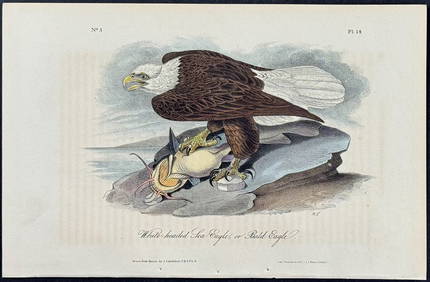
Audubon - White-headed Sea Eagle or Bald Eagle. 14Trillium Antique Prints & Rare Books4.5(32)See Sold PriceFeb 24, 2024
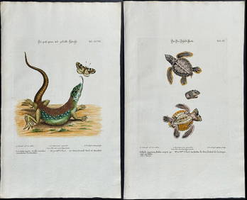
Edwards & Seligmann - 5 Engravings of Lizards, Snake, & Sea TurtleTrillium Antique Prints & Rare Books4.5(32)See Sold PriceFeb 24, 2024
Southern Africa Cape of Good Hope-Madagascar ADMIRALTY sea chart 1935 (1955) mapJasper524.5(9.9k)See Sold PriceFeb 28, 2024
Ocean sunfish. Opah Moonfish. Orsie Petinbuaba Filefish. West African Fish 1745Jasper524.5(9.9k)See Sold PriceFeb 28, 2024
West Africa. Kingfish Swordfish Marlin Gillbacker sea catfish. Fetish tree 1748Jasper524.5(9.9k)See Sold PriceFeb 28, 2024
La Nubia ed Abissinia. Red Sea Ethiopia Sudan Eritrea Arabia. ZATTA 1785 mapJasper524.5(9.9k)See Sold PriceFeb 28, 2024
NILE VALLEY. Upper & Lower. Egypt Sinai Nubia Sudan Abyssinia. BLACKIE 1886 mapJasper524.5(9.9k)See Sold PriceFeb 28, 2024
Gulf of Guinea. Ghana Togo Benin Nigeria. ADMIRALTY sea chart 1928 (1954) mapJasper524.5(9.9k)See Sold PriceFeb 28, 2024
South Namibia coast. Walvis Bay-Orange River ADMIRALTY sea chart 1881 (1954) mapJasper524.5(9.9k)See Sold PriceFeb 28, 2024
NILE VALLEY. Upper & Lower. Egypt Sinai Nubia Sudan Abyssinia. BLACKIE 1882 mapJasper524.5(9.9k)See Sold PriceFeb 28, 2024
Young Crocodile, drawn in London October 1739. Sea toad. Cuttlefish. SCHLEY 1747Jasper524.5(9.9k)See Sold PriceFeb 28, 2024
West Africa. Kingfish Swordfish Gillbacker sea catfish. Fetish tree. SCHLEY 1748Jasper524.5(9.9k)See Sold PriceFeb 28, 2024
Stanford, Edward 1901 Large Map. Sea of Marmara. TurkeyAlbion Auctions4.6(341)See Sold PriceMar 01, 2024
POMPONIUS MELA 1784 ANTIQUE SCHOOL PRIMED VELLUM BINDING CLASSICAL LATIN WORKSNY Elizabeth 4.2(86)See Sold PriceMar 03, 2024
Antique Map - Views on the coast of Asia. J. Webber del. Engraved after J. Webber and W. Bligh.Proverde Auctions4.3(3)See Sold PriceFeb 28, 2024