ATLAS of ANTIENT GEOGRAPHY by SAMUEL BUTLER 1843John McInnis Auctioneers,LLC4.6(502)See Sold PriceFeb 24, 2024
18TH C. ANTIQUE MAP: FRENCH & INDIAN WAR, FRAMEDThomaston Place Auction Galleries4.4(386)See Sold PriceFeb 24, 2024
Rand McNally Railroad Map Cabinet w/ 21 Railroad MapsRail & Road Auctions4.6(165)See Sold PriceMar 08, 2024
Keith Haring - Ink on New York Map, Best Buddies, Inscribed, Signed, and DatedSapphire Auction Gallery4(67)See Sold PriceMar 02, 2024
LATE 17TH C. FRENCH MAP OF THE NEW WORLD BY ALEXIS-HUBERT JAILLOT (1632-1712)Thomaston Place Auction Galleries4.4(386)See Sold PriceFeb 24, 2024
Central Railroad of New Jersey Map of Sandy Hook Route-ca. 1903JM Hobby Supply and Railroad Artifact Auctions4.4(126)See Sold PriceFeb 24, 2024
Lot of Six Mixed Atlas Box Cars-HO Scale-New in BoxJM Hobby Supply and Railroad Artifact Auctions4.4(126)See Sold PriceFeb 25, 2024
Rand McNally/Santa Fe Railroad Map of Iowa-1912JM Hobby Supply and Railroad Artifact Auctions4.4(126)See Sold PriceFeb 24, 2024
NICOLAES VISSCHER (NETHERLANDS, 1618-1709) MAP OF THE NEW WORLDThomaston Place Auction Galleries4.4(386)See Sold PriceFeb 24, 2024
17TH C. WORLD MAP BY NICOLAES VISSCHER (NETHERLANDS, 1618-1709)Thomaston Place Auction Galleries4.4(386)See Sold PriceFeb 24, 2024
Lot of Six Mixed Atlas Cabooses-HO Scale-New in BoxJM Hobby Supply and Railroad Artifact Auctions4.4(126)See Sold PriceFeb 25, 2024
Amer.Sep. Partie Du Mexique. [Utah and Adjacent]Title/Content of Map: Amer.Sep. Partie Du Mexique. [Utah and Adjacent] Date Printed: 1827 Cartographer: VANDERMAELEN, PHILIPPE MARIE GUILLAUME (1795-1869) Size: 18.5X22.5 Some restorations.The AmericaSee Sold Price
Amer.Sep. Partie Du Mexique. [Utah and Adjacent]Title: Amer.Sep. Partie Du Mexique. [Utah and Adjacent] Publication Date: 1827 Cartographer: VANDERMAELEN, PHILIPPE MARIE GUILLAUME (1795-1869) Publisher: VANDERMAELEN Size: 18.5Height - 22.5Width TheSee Sold Price
Large-scale map of Utah & Nevada 1827Title: Amer. Sep. Partie du Mexique. No. 47 Author: Vandermaelen, Philippe Marie Guillaume Description: Lithographed map. 46x56 cm. (18x22").Much of present-day Utah and Nevada, on a very large scale.See Sold Price
SoldLarge-scale map of Utah & Nevada 1827Title: Amer. Sep. Partie du Mexique. No. 47 Author: Vandermaelen, Philippe Marie Guillaume Description: Lithographed map. 46x56 cm. (18x22").Much of present-day Utah and Nevada, on a very large scale.See Sold Price
Amer.Sep. Partie Du Mexique. No.60. [Gulf Coast ofTitle/Content of Map: Amer.Sep. Partie Du Mexique. No.60. [Gulf Coast of Texas and Part of Mexico] Cartographer: VANDERMAELEN, PHILIPPE MARIE GUILLAUME (1795-1869) Date: 1827 Publisher: VANDERMAELEN SSee Sold Price
Amer.Sep. Partie Du Mexique. No.60. [Gulf Coast ofTitle: Amer.Sep. Partie Du Mexique. No.60. [Gulf Coast of Texas and Part of Mexico] Publication Date: 1827 Publisher: VANDERMAELEN Size: 18.1 x 20.1 A very clean example of one of the earliest accuratSee Sold Price
Amer.Sep. Partie Du Mexique. No.60. [Gulf Coast ofReserve Reduced! Title/Content of Map: Amer.Sep. Partie Du Mexique. No.60. [Gulf Coast of Texas and Part of Mexico] Date: 1827 Cartographer: VANDERMAELEN, PHILIPPE MARIE GUILLAUME (1795-1869) PublisheSee Sold Price
Amer. Sep. Partie Du Mexique. No. 65Title: Amer. Sep. Partie Du Mexique. No. 65 Publication Date: 1827 Cartographer: VANDERMAELEN, PH. M. G. Publisher: VANDERMAELEN, Size: 18.3X21.25 Map 65 from his 400 sheet Atlas universelle of 1827,See Sold Price
MAP, Mexico & Ecuador, VandermaelenSouthwest Mexico; Chimborazo, Ecuador. Vandermaelen, Amer. Sep. Partie du Mexique. No. 70, from Atlas Universel de Geographie..., 1825-27 (published). Hand Color. This map covers the Mexican coastlineSee Sold Price
SoldLarge-scale map of part of Mexico 1827Title: Amer. Sep. Partie du Mexique. No. 60 Author: Vandermaelen, Philippe Marie Guillaume Description: Lithographed map, hand-colored in outline. 46x50 cm. (18x19½").The coast of northeastern MexicoSee Sold Price
MAP, Mexico & Ecuador, VandermaelenSouthwest Mexico; Chimborazo, Ecuador. Vandermaelen, Amer. Sep. Partie du Mexique. No. 70, from Atlas Universel, 1825-27 (published). Hand Color. This map covers the Mexican coastline from Zacatula (LSee Sold Price
Large-scale map of part of Mexico 1827Title: Amer. Sep. Partie du Mexique. No. 60 Author: Vandermaelen, Philippe Marie Guillaume Description: Lithographed map, hand-colored in outline. 46x50 cm. (18x19½").The coast of northeastern MexicoSee Sold Price
Mexico's West Coast from Vandermaelen AtlasHeading: Author: Vandermaelen, Philippe Marie Guillaume Title: Amér. Sep. No. 70. Partie Du Mexique Place Published: [Brussels] Publisher: Date Published: [1827] Description:See Sold Price
Amér. Sep. Partie de Mexique #47. Utah. Great Salt Lake. VANDERMAELEN 1827 mapTitle: Amér. Sep. Partie de Mexique #47. Utah. Great Salt Lake. VANDERMAELEN 1827 map Description: Amér. Sep. - Partie de Mexique - No. 47' by Philippe Marie Guillaume Vandermaelen. LithograSee Sold Price
MAP - Gulf of Mexico & Caribbean. BrueGulf of Mexico & Caribbean. Adrien Hubert Brue, Carte des Iles Antilles ou Indes Occidentales, du Golfe du Mexique et d'une Partie des Pays Adjacents, 1825 (dated). Hand Color. The beautifully engraveSee Sold Price
Soldde Vaugondy. Partie du Mexique òu de la Nouv...[Central America] Robert de Vaugondy, Gilles (French, 1688-1766). "Partie du Mexique òu de la Nouv. le Espagne ou se trouve l'Audience de Guadalajara, Nouveau Mexique, Nouvelle Navarre, Californie, eSee Sold Price
Sold1749 Robert de Vaugondy Map of Texas and NorthernTitle: 1749 Robert de Vaugondy Map of Texas and Northern Mexico -- Partie Du Mexique ou De La Nouvle. Espagne ou se trouve L'Audce De Guadalajara, Nouveau Mexique, Nouvelle Navarre, Californie &c. DatSee Sold Price
United States, Canada and part of Mexico. 1871.Map of the United States, Canada and part of Mexico. North America. 1871.Print from steel engraving titled „Carte physique des Etats-Unis Canada et partie du Mexique“.Author/compiler - MM. DriouxSee Sold Price
1749 Robert de Vaugondy Map of Texas and NorthernTitle/Content of Map: 1749 Robert de Vaugondy Map of Texas and Northern Mexico -- Partie Du Mexique ou De La Nouvle. Espagne ou se trouve L'Audce De Guadalajara, Nouveau Mexique, Nouvelle Navarre, CalSee Sold Price
Vandermaelen, Jean-François. America Septentrional,Vandermaelen, Jean-François. America Septentrional, Partie du Mexique. Brussels, 1825 - 1827. Engraved maps, 51 x 62cm. Framed. 4 Items.See Sold Price
SoldCarl Nebel (German, 1805-1855)Carl Nebel (German, 1805-1855) , 22 hand-colored lithographs, c. 1840, from Voyage Pittorésque et Archéologique dans la Partie la Plus Intéressante du Méxique, second edition, 17 with typed labelsSee Sold Price
Dépot Général de la Marine. Carte Réduite de laDépot Général de la Marine. Carte Réduite de la Partie Méridionale du Golfe du Mexique Depuis le Cap Catoche... France: 1826. Grabado.See Sold Price
SoldMilne Edwards, H.: Recherches zoologiques Milne Edwards, H. Recherches zoologiques pour servir à l'histoire de la faune de l'Amérique Centrale et du Mexique. Première partie (von 2). 3 Bl., 148 S., 22 Bl. Mit 21 getöSee Sold Price
Brué/Levasseur: Antique Map of Mexico/Southwest US 1876Carte Generale du Mexique et de la Partie Sud-Ouest des Etats Unis Brue's important map of post-independence Mexico, revised by Levasseur to reflect Mexico's losses in the Mexican-American War and theSee Sold Price
RIGOBERT BONNE c1787 Original Colored Map Germany & Region 15" x 12"Luis Porretta Fine Arts4.3(10)See Sold PriceMar 02, 2024
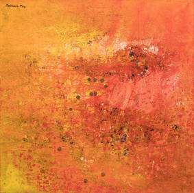
SAVANN THAV (artiste cambodgien né en 1956) : Composition au fond rouge jaune et rouge. Toile. 100Valoir Pousse-Cornet4.3(4)See Sold PriceFeb 24, 2024
1764 Bellin Map of Lesser Antilles Northern Portion -- Petites Antilles ou Isles du Vent 3e. Partie.Jasper524.5(9.8k)See Sold PriceFeb 27, 2024
1764 Bellin Map of Southern Portion of Martinique -- Partie Meridionale de la MartiniqueJasper524.5(9.8k)See Sold PriceFeb 27, 2024
Afrique. Partie du Sahara #16. Niger & Chad Libya. VANDERMAELEN 1827 old mapJasper524.5(9.8k)See Sold PriceFeb 28, 2024
Afrique. Partie du Désert de Sahara #13. Mauritania Mali. VANDERMAELEN 1827 mapJasper524.5(9.8k)See Sold PriceFeb 28, 2024
Partie de la Coste d'Afrique depuis Tanit…' Southern Mauritania BELLIN 1746 mapJasper524.5(9.8k)See Sold PriceFeb 28, 2024
Afrique. Partie du Sahara #12. Mauritania. Western Sahara. VANDERMAELEN 1827 mapJasper524.5(9.8k)See Sold PriceFeb 28, 2024
Partie de la Coste d'Afrique'. Southern Mauritania BELLIN/SCHLEY 1747 old mapJasper524.5(9.8k)See Sold PriceFeb 28, 2024
NORTH AFRICA. 'Biledulgerid', a former North African country. MALLET 1683 mapJasper524.5(9.8k)See Sold PriceFeb 28, 2024
Afrique. Pays des Hottentots #50. Namibia South Africa VANDERMAELEN 1827 mapJasper524.5(9.8k)See Sold PriceFeb 28, 2024
Partie Occidentale de l’Afrique. West Africa coast Canary islands BONNE 1788 mapJasper524.5(9.8k)See Sold PriceFeb 28, 2024
NORTH AFRICA. Barbary. Morocco Tunisia Libya Egypt. 'Barbarie'. MALLET 1683 mapJasper524.5(9.8k)See Sold PriceFeb 28, 2024
Partie Occidentale de l'Ancien Continent… W Africa Macaronesia. BONNE 1780 mapJasper524.5(9.8k)See Sold PriceFeb 28, 2024
Colonel Lussan Souvenirs Du Mexique SoftcoverRapid Estate Liquidators and Auction Gallery4.5(1.1k)See Sold PriceFeb 27, 2024
Souvenirs Du Mexique Colonel Lussan Published in 1899Rapid Estate Liquidators and Auction Gallery4.5(1.1k)See Sold PriceFeb 29, 2024
Souvenirs Du Mexique 1864-1867 Par Le Général Baron Van Der SmissenRapid Estate Liquidators and Auction Gallery4.5(1.1k)See Sold PriceFeb 29, 2024
![Amer.Sep. Partie Du Mexique. [Utah and Adjacent] First Image](https://p1.liveauctioneers.com/5584/117686/60488631_1_x.jpg?height=282&quality=95&version=1520991879&width=282)

![Amer.Sep. Partie Du Mexique. [Utah and Adjacent] First Image](https://p1.liveauctioneers.com/5584/117686/60488631_1_x.jpg?height=282&quality=1&version=1520991879&width=282)


![Amer.Sep. Partie Du Mexique. [Utah and Adjacent] (1 of 9)](https://p1.liveauctioneers.com/5584/117686/60488631_1_x.jpg?height=282&quality=70&version=1520991879)
![Amer.Sep. Partie Du Mexique. [Utah and Adjacent] (1 of 10)](https://p1.liveauctioneers.com/5584/144953/73284203_1_x.jpg?height=282&quality=70&version=1562102885)