ATLAS of ANTIENT GEOGRAPHY by SAMUEL BUTLER 1843John McInnis Auctioneers,LLC4.5(505)See Sold PriceFeb 24, 2024
18TH C. ANTIQUE MAP: FRENCH & INDIAN WAR, FRAMEDThomaston Place Auction Galleries4.4(394)See Sold PriceFeb 24, 2024
Rand McNally Railroad Map Cabinet w/ 21 Railroad MapsRail & Road Auctions4.6(165)See Sold PriceMar 08, 2024
Keith Haring - Ink on New York Map, Best Buddies, Inscribed, Signed, and DatedSapphire Auction Gallery4.1(67)See Sold PriceMar 02, 2024
LATE 17TH C. FRENCH MAP OF THE NEW WORLD BY ALEXIS-HUBERT JAILLOT (1632-1712)Thomaston Place Auction Galleries4.4(394)See Sold PriceFeb 24, 2024
Central Railroad of New Jersey Map of Sandy Hook Route-ca. 1903JM Hobby Supply and Railroad Artifact Auctions4.4(127)See Sold PriceFeb 24, 2024
Lot of Six Mixed Atlas Box Cars-HO Scale-New in BoxJM Hobby Supply and Railroad Artifact Auctions4.4(127)See Sold PriceFeb 25, 2024
Rand McNally/Santa Fe Railroad Map of Iowa-1912JM Hobby Supply and Railroad Artifact Auctions4.4(127)See Sold PriceFeb 24, 2024
NICOLAES VISSCHER (NETHERLANDS, 1618-1709) MAP OF THE NEW WORLDThomaston Place Auction Galleries4.4(394)See Sold PriceFeb 24, 2024
17TH C. WORLD MAP BY NICOLAES VISSCHER (NETHERLANDS, 1618-1709)Thomaston Place Auction Galleries4.4(394)See Sold PriceFeb 24, 2024
Lot of Six Mixed Atlas Cabooses-HO Scale-New in BoxJM Hobby Supply and Railroad Artifact Auctions4.4(127)See Sold PriceFeb 25, 2024
SoldVisscher map of New England with view of NYHeading: Author: Visscher, Nicolas Title: Novi Belgii Novaeque Angliae nec non Partis Virginiae Tabula Multis in Locis Emendata Place Published: Amsterdam Publisher: Date Published: c.1684See Sold Price
SoldVISSCHER, NICOLAS. Novi Belgii Novaeque Angliae Nec NonVISSCHER, NICOLAS. Novi Belgii Novaeque Angliae Nec Non Partis Virginiae Tabula. Double-page engraved map of New England with an inset view of New Amsterdam. 19½x23 inches sheet size, ample margiSee Sold Price
Sold1730 Original Seutter Map New England, NYOriginal 1730 hand-colored map in Latin and Dutch "Recens edita totius Novi Belgii in America Septentrionali," by Matthew Sutter (German), illustrating the north-eastern region of what is now the UnitSee Sold Price
c1676 Handcolored JOHN SPEED Map New England + NYHistoric Maps c. 1676 Hand-Colored Copper Plate Engraved Map titled "A Map of New England and New York" by John Speed c. 1676, Original Hand-Colored, Classic Copper Plate Engraved Map titled, "A Map oSee Sold Price
c.1676 Handcolored JOHN SPEED Map New England, NYHistoric Maps c. 1676 John Speed "A Map of New England and New York" Hand-Colored Copper Plate Decorative Engraved Map c. 1676, Original Hand-Colored, Classic Copper Plate Engraved Map titled, "A MapSee Sold Price
SoldJohn Speed's ca 1676 hnd colored copper plate engraJohn Speed's ca 1676 hnd colored copper plate engraved Map of New England & NY bearing the imprint of Basset & Chiswell London (very rare – one of only a small group of English maps of New England pSee Sold Price
early 19th century map of New England and NY in 16early 19th century map of New England and NY in 1697 engraved and printed by Fenner, Sears and CoSee Sold Price
SoldLOTTERS MAP OF NEW ENGLAND INC. EARLY VIEW OF NYC 17TH17TH OR 18THC. 2ND OR 4TH STATE, BASED ON J. JANSSON MAP OF 1651 (19" X 22 3/8" PLATE SIZE)See Sold Price
SoldThomas Jeffreys Map New England (CT, MA, RI, NY)Frame: 46.5" x 28 5/8" Image sight: 38.75" x 20.5". Lower half of full map, appears to be glued down.See Sold Price
c. 1650 Map - NY & New England“Upside Down” Map of New York and New England! c. 1650, [NEW YORK & NEW ENGLAND]: “NOVA BELGICA ET ANGLIA NOVA,” by Willem Blaeu, Amsterdam, Fine. 15.25” x 20” handSee Sold Price
SoldDANCKERTS, JUSTUS. Novi Belgii Novae Que Angliae NecDANCKERTS, JUSTUS. Novi Belgii Novae Que Angliae Nec Non Pennsylvaniae et Partis Virginiae Tabula. Double-page engraved map of New England with inset view of lower Manhattan. 19½x22¾ inchesSee Sold Price
Soldca. 1920 postcard album with New England viewsca. 1920 full postcard album with New England and NY views including some RPPCs, Vermont views, town views, etc.See Sold Price
Soldca 1825 hand colored map of Northern New England &ca 1825 hand colored map of Northern New England & Upper State NY - 20"x23 1/3" sight sizeSee Sold Price
SoldNovi Belgii Novaeque Angliae"Novi Belgii Novaeque Angliae nec non Partis Virginiae Tabula" early New England map after Nicolaes Visscher (Dutch, 1618-1709), color facsimile printed on wove paper, ca. 1900, watermarked "Van GeldeSee Sold Price
SoldNovi Belgii Novaeque Angliae Map after Visscher"Novi Belgii Novaeque Angliae nec non Partis Virginiae Tabula" early New England map after Nicolaes Visscher (Dutch, 1618-1709), color facsimile printed on wove paper, ca. 1900, watermarked "Van GeldeSee Sold Price
SoldNew England & NY Travel Folders - 16Some nice travel folders and maps. A fine 1907 B&M Resorts map, Hoosac Tunnel & western booklet, A few Hoosac Tunnel folders, Mt Washington Cog Railway folders. more.See Sold Price
SoldThat part of America which was… New England NY St Lawrence. GENTS MAG 1757 mapTitle: That part of America which was… New England NY St Lawrence. GENTS MAG 1757 map Description: A map of that part of America which was the principal seat of war in 1756' by Unattributed (175See Sold Price
That part of America which was New England NY StTITLE/CONTENT OF MAP: 'A map of that part of America which was the principal seat of war in 1756' The map refers to and shows the theatre/theater of the French and Indian War. It covers much of New EnSee Sold Price
SoldCollection of Maps19th and 20th c maps including Maine, NY and New England, Various ages, various states approx 15pcsSee Sold Price
SoldGRP OF APROX 45 STATE ROAD MAPS & TOUR PAMPHLETS FROMGRP OF APROX 45 STATE ROAD MAPS & TOUR PAMPHLETS FROM 1930'S TO 70'S; (2) 1927 AUTO TRAILS OF NEW ENGLAND & EASTERN N.Y.; 1920 SYRACUSE,N.Y. STREET DIRECTORY/MAP, GRP OF APROX. 50 STATE MAPS & TOUR PASee Sold Price
SoldTravels in New England and NY by Timothy DwightTitle: Travels in New England and New York Author: Dwight, Timothy Description: 4 volumes. 524; 527; 534; 527 pp. Three folding maps. (4to) 8¾x5, original tan cloth-backed boards with paper spine labSee Sold Price
Sold18th C. English Map of Northeast US18th century English map, depicting New England and New York, by Thomas Basset and Richard Chiswell, 15" 1/8" h x 19 3/4" w (view), 22 1/4" h x 17 1/4" w (frame). Provenance: from a Massachusetts estaSee Sold Price
SoldLot of 2 framed mapsNovi Begii map of New England & Map of the Worls by Nicholas Visscher. 24"h x 27"w framed.See Sold Price
NICOLAES VISSCHER (NETHERLANDS, 1618-1709) MAP OF THE NEW WORLDThomaston Place Auction Galleries4.4(394)See Sold PriceFeb 24, 2024
Vintage County Map Of NY State Plate EngravingThe Benefit Shop Foundation Inc.4.3(3k)See Sold PriceFeb 28, 2024
2018-19 Super Bowl LIII New England Patriots Inspired Championship RingWeatherham Estate Treasures3.9(159)See Sold PriceMar 07, 2024
1919 The Story of The Great War by Official Sources Volumes 1,2,3,8.North American Artifact Auctions4.7(201)See Sold PriceApr 20, 2024
1849 THE NEW-ENGLAND MERCANTILE UNIONNorth American Artifact Auctions4.7(201)See Sold PriceApr 20, 2024
1943 USA Undercover Mail Cover New York NY to London England Czech ArmyMynt Auctions4.6(711)See Sold PriceFeb 27, 2024
[MAP]. [ALBRIZZI, Giambatista, 1698-1777]. Carta Geografica...Potter & Potter Auctions4.6(550)See Sold PriceMar 07, 2024
[BASEBALL]. Group of Four Postcards Featuring Ballparks, in...Potter & Potter Auctions4.6(550)See Sold PriceMar 07, 2024
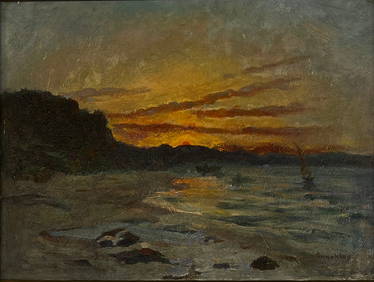
EDMUND CHARLES TARBELL (1862-1938) "EMELINA AND JOSE".Amelia Jeffers, Auctioneers & Appraisers4.5(124)See Sold PriceMar 07, 2024
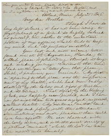
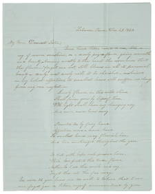
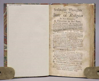
ANTIQUE AMERICANA, 1743: SEASONABLE THOUGHTS ON THE STATE OF RELIGION IN NEW ENGLANDNY Elizabeth 4.1(88)See Sold PriceMar 03, 2024
(2) ANTIQUE CAMERAS, EASTMAN NEW VIEW & SMALL FOLDAustin Auction Gallery4.7(1.2k)See Sold PriceApr 12, 2024
Vintage SPNEA Society For Preservation of New England Gold Tone ANGEL Brooch PinAnnzstiques Auction House4.5(630)See Sold PriceJan 05, 2025


![[MAP]. [ALBRIZZI, Giambatista, 1698-1777]. Carta Geografica... (1 of 1)](https://p1.liveauctioneers.com/928/318880/171361280_1_x.jpg?height=282&quality=70&version=1707501302)
![[BASEBALL]. Group of Four Postcards Featuring Ballparks, in... (1 of 2)](https://p1.liveauctioneers.com/928/318880/171361369_1_x.jpg?height=282&quality=70&version=1707501302)