ATLAS of ANTIENT GEOGRAPHY by SAMUEL BUTLER 1843John McInnis Auctioneers,LLC4.5(505)See Sold PriceFeb 24, 2024
18TH C. ANTIQUE MAP: FRENCH & INDIAN WAR, FRAMEDThomaston Place Auction Galleries4.4(393)See Sold PriceFeb 24, 2024
Rand McNally Railroad Map Cabinet w/ 21 Railroad MapsRail & Road Auctions4.6(165)See Sold PriceMar 08, 2024
Keith Haring - Ink on New York Map, Best Buddies, Inscribed, Signed, and DatedSapphire Auction Gallery4.1(67)See Sold PriceMar 02, 2024
LATE 17TH C. FRENCH MAP OF THE NEW WORLD BY ALEXIS-HUBERT JAILLOT (1632-1712)Thomaston Place Auction Galleries4.4(393)See Sold PriceFeb 24, 2024
Central Railroad of New Jersey Map of Sandy Hook Route-ca. 1903JM Hobby Supply and Railroad Artifact Auctions4.4(127)See Sold PriceFeb 24, 2024
Lot of Six Mixed Atlas Box Cars-HO Scale-New in BoxJM Hobby Supply and Railroad Artifact Auctions4.4(127)See Sold PriceFeb 25, 2024
Rand McNally/Santa Fe Railroad Map of Iowa-1912JM Hobby Supply and Railroad Artifact Auctions4.4(127)See Sold PriceFeb 24, 2024
NICOLAES VISSCHER (NETHERLANDS, 1618-1709) MAP OF THE NEW WORLDThomaston Place Auction Galleries4.4(393)See Sold PriceFeb 24, 2024
17TH C. WORLD MAP BY NICOLAES VISSCHER (NETHERLANDS, 1618-1709)Thomaston Place Auction Galleries4.4(393)See Sold PriceFeb 24, 2024
Lot of Six Mixed Atlas Cabooses-HO Scale-New in BoxJM Hobby Supply and Railroad Artifact Auctions4.4(127)See Sold PriceFeb 25, 2024
Seutter: Map of Scandanavia with Baltic stated, 1740Title/Content of Map: Scandanavia with Baltic stated by Seutter Date Printed: c1740 Cartographer: Matthaus Seutter Material/Medium: Paper Size: 19" x 23" Original hand colored copperplate engraved. PuSee Sold Price
Seutter: Antique Map of Scandanavia, Baltic States 1740Title/Content of Map: Scandanavia with Baltic States by Seutter Date Printed: c1740 Cartographer: Matthaus Seutter Material/Medium: Paper Size: 19" x 23" Original hand colored copperplate engraved. PuSee Sold Price
Seutter: Antique Map of Scandanavia, 1740Title/Content of Map: Scandanavia by Seutter Date Printed: c1740 Cartographer: Matthaus Seutter Material/Medium: Paper Size: 19 1/3" x 23 2/3" Original hand colored copperplate engraved. Published inSee Sold Price
Seutter: Antique Map of Prussia & Baltic Coast, 1740Title/Content of Map: Prussia with the Baltic Coast Date Printed: c1740 Cartographer: Matthaus Seutter Material/Medium: Paper Size: 19 1/2" x 23 2/3" Original hand colored copperplate engraved. PublisSee Sold Price
SoldScandanavia with Baltic States by SeutterTitle/Content of Map: Scandanavia with Baltic States by Seutter Date: c1740 Cartographer: Matthaus Seutter Material/Medium: Paper Size: 19" x 23" Provenance: New York Original hand colored coppeprlateSee Sold Price
Scandanavia with Baltic States by SeutterTitle/Content of Map: Scandanavia with Baltic States by Seutter Date Printed: c1740 Cartographer: Matthaus Seutter Material/Medium: Paper Size: 19" x 23" Provenance: New York Original hand colored copSee Sold Price
Map of Scandanavia with Baltic States by SeutterTitle/Content of Map: Scandanavia with Baltic States by Seutter Date Printed: c1740 Cartographer: Matthaus Seutter Material/Medium: Paper Size: 23" x 19" Provenance: New York Original hand colored copSee Sold Price
Map of Scandanavia with Baltic states by SeutterTitle/Content of Map: Scandanavia with Baltic states by Seutter Date Printed: c1740 Cartographer: Matthaus Seutter Material/Medium: Paper Size: 19" x 23" Provenance: New York Original hand colored copSee Sold Price
SoldSeutter: Antique Map of Old Kingdom of Poland, 1740Title/Content of Map: Old Kingdom of Poland & Lithuania. Shows Baltic area & parts of Finland Date Printed: c1740 Cartographer: Matthaus Seutter Material/Medium: Paper Size: 20" x 24" Original hand coSee Sold Price
SoldSeutter: Antique Map of East Prussia, 1740Title/Content of Map: Today's northern Poland. East Prussia. Poland and Baltic regions by Seutter Date Printed: c1740 Cartographer: Mattaus Seutter Material/Medium: Paper Size: 19" x 23" Original handSee Sold Price
SoldMatthaus Seutter, Map, c. 1740Matthaus Seutter, "Mappa Geographica Regionem Mexicanam et Floridam...", Augsburg, c. 1740, hand-colored, with inset maps of Havana, Portobell, Cartagena and Vera Cruz, with vignettes of a sea battleSee Sold Price
Seutter: Map of Barcelona, 1740Barcellona die Haupt Statt des Spanischen Fürstenthums Catalonien Seutter's detailed plan of the Catalan capital of Barcelona in contemporary color, with an uncolored view of the city beneath it. BotSee Sold Price
1740 Seutter Map of Japan -- Imperium Japonicum perTitle/Content of Map: 1740 Seutter Map of Japan -- Imperium Japonicum per Sexaginta et Sex Regiones Digestum atque ex Ipsorum Japonensium Mappis Descriptum … Date Printed: 1740 c., Augsburg CartograSee Sold Price
Sold1740 Seutter Map of Japan -- Imperium Japonicum perTitle/Content of Map: 1740 Seutter Map of Japan -- Imperium Japonicum per Sexaginta et Sex Regiones Digestum atque ex Ipsorum Japonensium Mappis Descriptum … Date: 1740 c., Augsburg Cartographer: MSee Sold Price
SoldMatthaus Seutter Map of France 1740Matthaus Seutter, Map of France, 1740. Titled "Provincia Gallis La Provence dicta". Measures 24-1/8" x 20.5" sheet size. Unframed, loose and not glued or mounted. Provenance: C.D. Raymond & Son collecSee Sold Price
1740 Seutter Map of Japan -- Imperium Japonicum perTitle/Content of Map: 1740 Seutter Map of Japan -- Imperium Japonicum per Sexaginta et Sex Regiones Digestum atque ex Ipsorum Japonensium Mappis Descriptum … Date Printed: 1740 c., Augsburg CartograSee Sold Price
1740 Seutter Map of Upper Austria -- Nova MappaTitle: 1740 Seutter Map of Upper Austria -- Nova Mappa Archiducatus Austriae Superioris Cartographer: Seutter [Family] Year / Place: 1740 c., Nurnberg Map Dimension (in.): 19.2 X 22.8 in. This is a loSee Sold Price
1740 Seutter Map of Upper Austria -- Nova MappaTitle: 1740 Seutter Map of Upper Austria -- Nova Mappa Archiducatus Austriae Superioris Cartographer: Seutter [Family] Year / Place: 1740 c., Nurnberg Map Dimension (in.): 19.2 X 22.8 in. This is a loSee Sold Price
1740 Seutter Map of Upper Austria -- Nova MappaTitle: 1740 Seutter Map of Upper Austria -- Nova Mappa Archiducatus Austriae Superioris Cartographer: Seutter [Family] Year / Place: 1740 c., Nurnberg Map Dimension (in.): 19.2 X 22.8 in. This is a loSee Sold Price
Seutter: Antique Map of Japan, 1740Title/Content of Map: 1740 Seutter Map of Japan -- Imperium Japonicum per Sexaginta et Sex Regiones Digestum atque ex Ipsorum Japonensium Mappis Descriptum … Date Printed: 1740 c., Augsburg CartograSee Sold Price
1740 Seutter Antique Map of JapanTitle/Content of Map: 1740 Seutter Map of Japan -- Imperium Japonicum per Sexaginta et Sex Regiones Digestum atque ex Ipsorum Japonensium Mappis Descriptum … Date Printed: 1740 c., Augsburg CartograSee Sold Price
1740 Seutter Antique Map of JapanTitle/Content of Map: 1740 Seutter Map of Japan -- Imperium Japonicum per Sexaginta et Sex Regiones Digestum atque ex Ipsorum Japonensium Mappis Descriptum … Date Printed: 1740 c., Augsburg CartograSee Sold Price
SoldSeutter: Opulentissimum Sinarum Imperium Map, 1740Opulentissimum Sinarum Imperium. Asia with Korea as Peninsula map by M. Seutter, 1740 (62.5 x 52.5 cm) Please note that this lot has a confidential reserve. When you leave a bid in advance of the auctSee Sold Price
Seutter: Antique Map of Italy, 1740Title/Content of Map: Italy by Seutter Date Printed: c1740 Cartographer: Matthaus Seutter Material/Medium: Paper Size: 19 2/3" x 23 1/3" Original hand colored copperplate engraved. Published in AugsbuSee Sold Price
Central Railroad of New Jersey Map of Sandy Hook Route-ca. 1903JM Hobby Supply and Railroad Artifact Auctions4.4(127)See Sold PriceFeb 24, 2024
HAROLD ROBBINS Dream Merchants 1949 1st First Edition With Dust Wrapper vgcLuis Porretta Fine Arts4.3(10)See Sold PriceMar 02, 2024
LATE 17TH C. FRENCH MAP OF THE NEW WORLD BY ALEXIS-HUBERT JAILLOT (1632-1712)Thomaston Place Auction Galleries4.4(393)See Sold PriceFeb 24, 2024
18TH C. ANTIQUE MAP: FRENCH & INDIAN WAR, FRAMEDThomaston Place Auction Galleries4.4(393)See Sold PriceFeb 24, 2024
MARTIN VILLALBA Three Baristas Limited Ed 11/50 Engraving Hand ColoredLuis Porretta Fine Arts4.3(10)See Sold PriceMar 02, 2024
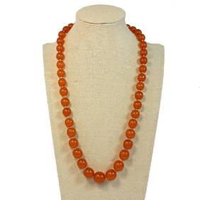
BEAUTIFUL NATURAL BALTIC BUTTERSCOTCH AMBER NECKLACE 61 GRAMS 21"Noble House Collection Gallery4.5(123)See Sold PriceMar 24, 2024
Keith Haring - Ink on New York Map, Best Buddies, Inscribed, Signed, and DatedSapphire Auction Gallery4.1(67)See Sold PriceMar 02, 2024
Rand McNally Railroad Map Cabinet w/ 21 Railroad MapsRail & Road Auctions4.6(165)See Sold PriceMar 08, 2024
18th Century Hess Germany Hand colored Engraved MapGlobal Auctions Company4.3(36)See Sold PriceMar 03, 2024
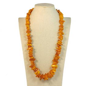
A FANTASTIC LARGE BALTIC AMBER NECKLACE 27" 111grNoble House Collection Gallery4.5(123)See Sold PriceFeb 28, 2024
A GENUINE BALTIC AMBER BUTTERSCOTCH NECKLACE 20" 37grNoble House Collection Gallery4.5(123)See Sold PriceFeb 28, 2024
Putnam - First Map of the State of Ohio by Rufus PutnamTrillium Antique Prints & Rare Books4.5(32)See Sold PriceFeb 24, 2024
1736 LARGE MAP OF SILESIA POLAND OPPAVIENSIS antique 25 by 34 3/4"Jasper524.5(9.9k)See Sold PriceFeb 27, 2024
BEAUTIFUL NATURAL BALTIC AMBER NECLACE 28" AND 68 GRAMSNoble House Collection Gallery4.5(123)See Sold PriceMar 10, 2024