ATLAS of ANTIENT GEOGRAPHY by SAMUEL BUTLER 1843John McInnis Auctioneers,LLC4.6(502)See Sold PriceFeb 24, 2024
18TH C. ANTIQUE MAP: FRENCH & INDIAN WAR, FRAMEDThomaston Place Auction Galleries4.4(386)See Sold PriceFeb 24, 2024
Rand McNally Railroad Map Cabinet w/ 21 Railroad MapsRail & Road Auctions4.6(165)See Sold PriceMar 08, 2024
Keith Haring - Ink on New York Map, Best Buddies, Inscribed, Signed, and DatedSapphire Auction Gallery4(67)See Sold PriceMar 02, 2024
LATE 17TH C. FRENCH MAP OF THE NEW WORLD BY ALEXIS-HUBERT JAILLOT (1632-1712)Thomaston Place Auction Galleries4.4(386)See Sold PriceFeb 24, 2024
Central Railroad of New Jersey Map of Sandy Hook Route-ca. 1903JM Hobby Supply and Railroad Artifact Auctions4.4(126)See Sold PriceFeb 24, 2024
Lot of Six Mixed Atlas Box Cars-HO Scale-New in BoxJM Hobby Supply and Railroad Artifact Auctions4.4(126)See Sold PriceFeb 25, 2024
Rand McNally/Santa Fe Railroad Map of Iowa-1912JM Hobby Supply and Railroad Artifact Auctions4.4(126)See Sold PriceFeb 24, 2024
NICOLAES VISSCHER (NETHERLANDS, 1618-1709) MAP OF THE NEW WORLDThomaston Place Auction Galleries4.4(386)See Sold PriceFeb 24, 2024
17TH C. WORLD MAP BY NICOLAES VISSCHER (NETHERLANDS, 1618-1709)Thomaston Place Auction Galleries4.4(386)See Sold PriceFeb 24, 2024
Lot of Six Mixed Atlas Cabooses-HO Scale-New in BoxJM Hobby Supply and Railroad Artifact Auctions4.4(126)See Sold PriceFeb 25, 2024
Thomson: Antique Map of Persia & Caspian Sea, 1817TITLE/CONTENT OF MAP: 'Persia [with Armenia]' A large map of the Persian Empire and adjacent territories including the Caspian and Aral Seas, and much of the Caucasus (modern Azerbaijan and Armenia).See Sold Price
Thomson: Antique Map of Persia & the Caspian Sea, 1817Title/Content of Map: 'Persia [with Armenia]' A large map of the Persian Empire and adjacent territories including the Caspian and Aral Seas, and much of the Caucasus (modern Azerbaijan and Armenia).See Sold Price
Thomson: Antique Map of Persia & the Caspian SeaTITLE/CONTENT OF MAP: 'Persia [with Armenia]' A large map of the Persian Empire and adjacent territories including the Caspian and Aral Seas, and much of the Caucasus (modern Azerbaijan and Armenia).See Sold Price
Bonne: Antique Map of Central & Southwest Asia, 1780Title/Content of Map: 'Carte de la Perse, de la Géorgie, et de la Tartarie Indépendante' A map of Central and southwest Asia; "Independent Tartary", Tibet, Persia, the Caspian Sea, Persia, Iraq, theSee Sold Price
Bonne: Antique Map of Central Asia, 1780TITLE/CONTENT OF MAP: 'Carte de la Perse, de la Géorgie, et de la Tartarie Indépendante' A map of Central and southwest Asia; "Independent Tartary", Tibet, Persia, the Caspian Sea, Persia, Iraq, theSee Sold Price
Bonne: Antique Map of Central & Southwest Asia, 1780TITLE/CONTENT OF MAP: 'Carte de la Perse, de la Géorgie, et de la Tartarie Indépendante' A map of Central and southwest Asia; "Independent Tartary", Tibet, Persia, the Caspian Sea, Persia, Iraq, theSee Sold Price
SoldAntique Map: Kingdom of PersiaRegnum Persicum Imperium Turcicum in Asia by Ottens (1730). Map of the Middle East with the Kingdom of the Persian, Empire in the Turkish province of Asia, Russia to the Caspian Sea. Copper engraving,See Sold Price
CASPIAN SEA. Baku Persia Astrakan. "Inner Kirghiz Horde". JOHNSTON 1910 mapTITLE/CONTENT OF MAP: 'Caspian Sea' DATE PRINTED: 1910 IMAGE SIZE: Approx 27.0 x 20.5cm, 10.5 x 8 inches (Medium) TYPE: Colour antique map CONDITION: Good; suitable for framing. However, please note:See Sold Price
CASPIAN SEA. Baku Persia Astrakan. "Inner Kirghiz Horde". JOHNSTON 1906 mapTITLE/CONTENT OF MAP: 'Caspian Sea' DATE PRINTED: 1906 IMAGE SIZE: Approx 20.5 x 27.0cm, 8 x 10.5 inches (Medium) TYPE: Colour antique map CONDITION: Good; suitable for framing. However, please note:See Sold Price
CASPIAN SEA. Baku Persia Astrakan. "Inner Kirghiz Horde". JOHNSTON 1899 mapTITLE/CONTENT OF MAP: 'Caspian Sea' DATE PRINTED: 1899 IMAGE SIZE: Approx 26.0 x 19.5cm, 10.25 x 7.75 inches (Medium) TYPE: Colour antique map CONDITION: Good; suitable for framing. However, please noSee Sold Price
CASPIAN SEA. Baku Persia Astrakan. "Inner Kirghiz Horde". JOHNSTON 1906 mapTITLE/CONTENT OF MAP: 'Caspian Sea' DATE PRINTED: 1906 IMAGE SIZE: Approx 20.5 x 27.0cm, 8 x 10.5 inches (Medium) TYPE: Colour antique map CONDITION: Good; suitable for framing. However, please note:See Sold Price
CASPIAN SEA. Baku Persia Astrakan. "Inner Kirghiz Horde". JOHNSTON 1910 mapTITLE/CONTENT OF MAP: 'Caspian Sea' DATE PRINTED: 1910 IMAGE SIZE: Approx 27.0 x 20.5cm, 10.5 x 8 inches (Medium) TYPE: Colour antique map CONDITION: Good; suitable for framing. However, please note:See Sold Price
CASPIAN SEA. Baku Persia Astrakan. "Inner Kirghiz Horde". JOHNSTON 1895 mapTITLE/CONTENT OF MAP: 'Caspian Sea' DATE PRINTED: 1895 IMAGE SIZE: Approx 26.5 x 20.0cm, 10.25 x 8 inches (Medium) TYPE: Antique colour map CONDITION: Good; suitable for framing. However, please note:See Sold Price
CASPIAN SEA. Baku Persia Astrakan. "Inner Kirghiz Horde". JOHNSTON 1900 mapTITLE/CONTENT OF MAP: 'Caspian Sea' DATE PRINTED: 1900 IMAGE SIZE: Approx 26.5 x 20.0cm, 10.25 x 7.75 inches (Medium) TYPE: Antique colour map CONDITION: Good; suitable for framing. However, please noSee Sold Price
SoldBowen: Antique Map of Caspian Sea Reserve, 1747Map: Caspian Sea Reserve Date Printed: 1747 Cartographer: E. Bowen Material/Medium: Paper Size: 10 1/4" x 14" Condition: Excellent Handcolored, copperplate engraved. Printed in London. From "A CompletSee Sold Price
Thomson: Antique Map of Persia, 1817Map: Persia. Publication Date: 1817 Cartographer: THOMSON, JOHN & CO. Publisher: JOHN THOMSON, JUNR. & CO. 1817 EDINBURGH Size: Double Folio – 17.50 H x 19.00 W Inches No.34 from Thomson's New GenerSee Sold Price
Sold(2) antique hand-colored maps: Caspian Sea and Jed(2) antique hand-colored maps: Caspian Sea and Jedso, 17th and 18th century, incl. Homann, larger: 21" x 25.25", unframedSee Sold Price
Basire: Antique Map Caucasus and Caspian Sea, 1748Title/Content of Map: 1748 Basire Map Southern Ukraine, Caucasus and Caspian Sea -- Bosporus, Maeotis, Iberia, Albania and Sarmatia Date Printed: 1748 London Cartographer: I Basire Size: 7.8 x 11.9 inSee Sold Price
Moll: Antique Map of The Caspian Sea, 1721Title/Content of Map: The Caspian Sea Drawn by the Czar's Special Command by Carl van Verden in the Year 1719. 1720 and 1721 Date Printed: 1721, London Cartographer: H Moll Size: 10.5 x 8.3 in. This mSee Sold Price
Moll: Antique Map of The Caspian Sea, 1721Title/Content of Map: The Caspian Sea Drawn by the Czar's Special Command by Carl van Verden in the Year 1719. 1720 and 1721 Date Printed: 1721, London Cartographer: H Moll Size: 10.5 x 8.3 in. This mSee Sold Price
Moll: Antique Map of the Caspian Sea, 1721Title/Content of Map: The Caspian Sea Drawn by the Czar's Special Command by Carl van Verden in the Year 1719. 1720 and 1721 Date Printed: 1721, London Cartographer: H Moll Size: 10.5 x 8.3 in. This mSee Sold Price
Cadell: Antique Map of the Caspian Sea Region, 1784Title/Content of Map: 1784 Cadell Map of the Caspian Sea Region -- Chart of the Caspian Sea Date Printed: 1784, London Cartographer: T Cadell Size: 7.5 x 6.3 in. A very nice map of the then recently eSee Sold Price
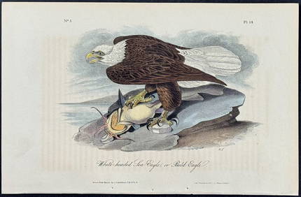
Audubon - White-headed Sea Eagle or Bald Eagle. 14Trillium Antique Prints & Rare Books4.5(30)See Sold PriceFeb 24, 2024
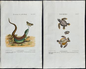
Edwards & Seligmann - 5 Engravings of Lizards, Snake, & Sea TurtleTrillium Antique Prints & Rare Books4.5(30)See Sold PriceFeb 24, 2024
Southern Africa Cape of Good Hope-Madagascar ADMIRALTY sea chart 1935 (1955) mapJasper524.5(9.8k)See Sold PriceFeb 28, 2024
Pre-colonial Africa. Mountains of Kong/Moon. Caravan routes. THOMSON 1817 mapJasper524.5(9.8k)See Sold PriceFeb 28, 2024
Ocean sunfish. Opah Moonfish. Orsie Petinbuaba Filefish. West African Fish 1745Jasper524.5(9.8k)See Sold PriceFeb 28, 2024
West Africa. Kingfish Swordfish Marlin Gillbacker sea catfish. Fetish tree 1748Jasper524.5(9.8k)See Sold PriceFeb 28, 2024
La Nubia ed Abissinia. Red Sea Ethiopia Sudan Eritrea Arabia. ZATTA 1785 mapJasper524.5(9.8k)See Sold PriceFeb 28, 2024
NILE VALLEY. Upper & Lower. Egypt Sinai Nubia Sudan Abyssinia. BLACKIE 1886 mapJasper524.5(9.8k)See Sold PriceFeb 28, 2024
Gulf of Guinea. Ghana Togo Benin Nigeria. ADMIRALTY sea chart 1928 (1954) mapJasper524.5(9.8k)See Sold PriceFeb 28, 2024
South Namibia coast. Walvis Bay-Orange River ADMIRALTY sea chart 1881 (1954) mapJasper524.5(9.8k)See Sold PriceFeb 28, 2024
NILE VALLEY. Upper & Lower. Egypt Sinai Nubia Sudan Abyssinia. BLACKIE 1882 mapJasper524.5(9.8k)See Sold PriceFeb 28, 2024
Young Crocodile, drawn in London October 1739. Sea toad. Cuttlefish. SCHLEY 1747Jasper524.5(9.8k)See Sold PriceFeb 28, 2024
West Africa. Kingfish Swordfish Gillbacker sea catfish. Fetish tree. SCHLEY 1748Jasper524.5(9.8k)See Sold PriceFeb 28, 2024
Stanford, Edward 1901 Large Map. Sea of Marmara. TurkeyAlbion Auctions4.6(336)See Sold PriceMar 01, 2024