ATLAS of ANTIENT GEOGRAPHY by SAMUEL BUTLER 1843John McInnis Auctioneers,LLC4.5(505)See Sold PriceFeb 25, 2024
18TH C. ANTIQUE MAP: FRENCH & INDIAN WAR, FRAMEDThomaston Place Auction Galleries4.4(393)See Sold PriceFeb 24, 2024
Rand McNally Railroad Map Cabinet w/ 21 Railroad MapsRail & Road Auctions4.6(165)See Sold PriceMar 08, 2024
Keith Haring - Ink on New York Map, Best Buddies, Inscribed, Signed, and DatedSapphire Auction Gallery4(67)See Sold PriceMar 02, 2024
LATE 17TH C. FRENCH MAP OF THE NEW WORLD BY ALEXIS-HUBERT JAILLOT (1632-1712)Thomaston Place Auction Galleries4.4(393)See Sold PriceFeb 24, 2024
Central Railroad of New Jersey Map of Sandy Hook Route-ca. 1903JM Hobby Supply and Railroad Artifact Auctions4.4(127)See Sold PriceFeb 24, 2024
Lot of Six Mixed Atlas Box Cars-HO Scale-New in BoxJM Hobby Supply and Railroad Artifact Auctions4.4(127)See Sold PriceFeb 25, 2024
Rand McNally/Santa Fe Railroad Map of Iowa-1912JM Hobby Supply and Railroad Artifact Auctions4.4(127)See Sold PriceFeb 24, 2024
NICOLAES VISSCHER (NETHERLANDS, 1618-1709) MAP OF THE NEW WORLDThomaston Place Auction Galleries4.4(393)See Sold PriceFeb 24, 2024
17TH C. WORLD MAP BY NICOLAES VISSCHER (NETHERLANDS, 1618-1709)Thomaston Place Auction Galleries4.4(393)See Sold PriceFeb 24, 2024
Lot of Six Mixed Atlas Cabooses-HO Scale-New in BoxJM Hobby Supply and Railroad Artifact Auctions4.4(127)See Sold PriceFeb 25, 2024
SoldTanner: Antique Map of Australia & Pacific Ocean, 1843Title/Content of Map: Australia and Pacific Ocean by Tanner Date Printed: 1843 Cartographer: H.C. Tanner Material/Medium: Paper Size: 17" x 14" Hand colored engraved Map based on the work of H.C. TannSee Sold Price
Detailed Antique Map - Australia - Pacific Ocean - New South Wales - SydneyTitle: Detailed Antique Map - Australia - Pacific Ocean - New South Wales - Sydney Date: c. 1888 Material: Paper Dimensions: 26” x 17” inches / 67 cm x 43 cm Descritpion: Detailed map of NSee Sold Price
Antique Map of Oceania & Pacific Ocean, 1843Title/Content of Map: Oceania Date Printed: 1843 Cartographer: based on the work of H.C. Tanner Material/Medium: Paper Size: 17" x 14" Hand colored engraved Map. From the first edition published by CaSee Sold Price
Original Antique Map - Australia - New South Wales - Sydney - Pacific OceanTitle/Artist: Original Antique Map - Australia - New South Wales - Sydney - Pacific Ocean Date: c. 1888 Material: Paper Dimensions: 67 cm x 43 cm Additional Information: This large original antique maSee Sold Price
SoldLapie: Antique Map of Australia & Pacific Islands, 1829Title/Content of Map: Australia & Pacific Ocean Islands Date Printed: 1829 Cartographer: A.E. Lapie Material/Medium: Paper Size: 17 1/2" x 23 1/2" Hand colored. Published in Paris. Pierre M. Lapie (17See Sold Price
Lapie: Antique Map of Australia & Pacific Islands, 1829Map: Australia & Pacific Ocean Islands Date Printed: 1829 Cartographer: A.E. Lapie Material/Medium: Paper Size: Approx 23 1/4" x 17 1/2" Condition: Very Good. Small tear in right center. Printed in PaSee Sold Price
Dufour/Dyonnet: Antique Map of Australia Oceania, 1860sOceanie dressee par A. H. Dufour A superbly detailed nautical chart of the Pacific Ocean showing all of Australia, Indonesia, and Japan as well as most of North America and the west coast of South. InSee Sold Price
SoldPACIFIC OCEAN Sandwich Islands/Hawaii Australia NewTITLE/CONTENT OF MAP: 'The Pacific Ocean' DATE PRINTED: 1863 IMAGE SIZE: Approx 47.0 x 65.0cm, 18.5 x 25.75 inches (Large); Please note that this is a folding map. TYPE: Antique map with original outlSee Sold Price
SoldPACIFIC OCEAN Sandwich Islands/Hawaii Australia NewReserve Reduced! TITLE/CONTENT OF MAP: 'The Pacific Ocean' DATE: 1863 IMAGE SIZE: Approx 47.0 x 65.0cm, 18.5 x 25.75 inches (Large); Please note that this is a folding map. TYPE: Antique map with origSee Sold Price
Weller: Antique Map of the Pacific Ocean, 1863Title/Content of Map: 'The Pacific Ocean' Sandwich Islands/Hawaii Australia New Zealand &c. Date Printed: 1863 Image Size: Approx 47.0 x 65.0cm, 18.5 x 25.75 inches (Large); Please note that this is aSee Sold Price
Weller: Antique Map of Pacific Ocean, 1863TITLE/CONTENT OF MAP: 'The Pacific Ocean' Sandwich Islands/Hawaii Australia New Zealand &c. DATE PRINTED: 1863 IMAGE SIZE: Approx 47.0 x 65.0cm, 18.5 x 25.75 inches (Large); Please note that this is aSee Sold Price
SoldHawaiian & Pacific Polynesian Islands, Australia, 1850Original engraving by Samuel Augustus Mitchell from Mitchell’s Universal Atlas, 1850. Map highlights the Pacific ocean & surrounding islands; Hawaii, Polynesian, Australia & New Zealand. Dimensions:See Sold Price
Times Atlas 1895 Antique Map. Pacific OceanLithograph Map Published 1895, London for "The Times Atlas" Paper Size: 16 x 10 inch (41 x 26cm) Good ConditionSee Sold Price
Times Atlas 1895 Antique Map. Pacific OceanLithograph Map Published 1895, London for "The Times Atlas" Paper Size: 16 x 10 inch (41 x 26cm) Good ConditionSee Sold Price
SoldArrowsmith: Antique Map of Pacific Ocean, 1823Title/Content of Map: 1823 Arrowsmith Map of Pacific Ocean -- Pacific Ocean Date Printed: 1823, London / Edinburgh Cartographer: A Arrowsmith Size: 9.8 x 8 in. A striking Arrowsmith map, with wonderfuSee Sold Price
Thomson: Antique Map of Pacific Ocean Islands, 1817Title/Content of Map: 'Map of the islands in the Pacific Ocean. Owhyhee/Hawaii. Karakakooa Bay, Owhyhee. Otaheite/Tahiti. Matavia Bay, Otaheite' Date Printed: 1817 Image Size: Approx 53.0 x 66.0cm, 21See Sold Price
SoldMitchell: Antique Map of Pacific Ocean Islands, 1869Title/Content of Map: Pacific Ocean Islands with Australia Date Printed: 1869 Cartographer: Augustus S. Mitchell Material/Medium: Paper Size: 15 1/3" x 12" Hand colored engraved Map. Published in PhilSee Sold Price
Thomson: Antique Map of Pacific Ocean Islands, 1817Title/Content of Map: 'Map of the islands in the Pacific Ocean. Owhyhee. Karakakooa Bay, Owhyhee. Otaheite. Matavia Bay, Otaheite' Date Printed: 1817 Image Size: Approx 53.0 x 66.0cm, 21 x 26 inches (See Sold Price
Bradford: Antique Map of Pacific Ocean & Islands, 1838Map: Pacific Ocean & Islands Date Printed: 1838-1841 Cartographer: Thomas G. Bradford Material/Medium: Paper Size: 16 3/4" x 13" Condition: Excellent Hand colored. A General Atlas of the World with aSee Sold Price
SoldTanner: Antique Map of Florida, 1843Title/Content of Map: Florida by Tanner Date Printed: 1843 Cartographer: H.C. Tanner Material/Medium: Paper Size: 17" x 14" Hand colored engraved Map based on the work of H.C. Tanner from the first edSee Sold Price
SoldTanner: Antique Map of Georgia, 1843Title/Content of Map: Georgia by Tanner Date Printed: 1843 Cartographer: based on the work of H.C. Tanner Material/Medium: Paper Size: 17" x 14" Hand colored engraved Map. From the first edition publiSee Sold Price
SoldTanner: Antique Map of Iowa, 1843Title/Content of Map: Iowa by Tanner Date Printed: 1843 Cartographer: based on the work of H.C. Tanner Material/Medium: Paper Size: 17" x 14" Hand colored engraved Map. From the first edition publisheSee Sold Price
SoldTanner: Antique Map of Michigan, 1843Title/Content of Map: Michigan by Tanner Date Printed: 1843 Cartographer: based on the work of H.C. Tanner Material/Medium: Paper Size: 17" x 14" Hand colored engraved Map. From the first edition publSee Sold Price
SoldTanner: Antique Map of Ohio, 1843Title/Content of Map: Ohio by Tanner Date Printed: 1843 Cartographer: based on the work of H.C. Tanner Material/Medium: Paper Size: 17" x 14" Hand colored engraved Map. From the first edition publisheSee Sold Price
EARLY 18TH C. DUTCH CHART OF PACIFIC OCEAN BY FREDERIK DE WIT (1629-1706) WITH CALIFORNIA AS ANThomaston Place Auction Galleries4.4(393)See Sold PriceFeb 24, 2024
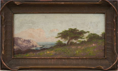
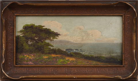
Antique California Coastal Beach Scene Pacific Ocean Framed American Impressionist Oil PaintingCurated Gallery Auctions4.6(131)See Sold PriceFeb 25, 2024
Antique California Coastal Beach Scene Pacific Ocean Framed American Impressionist Oil PaintingCurated Gallery Auctions4.6(131)See Sold PriceFeb 25, 2024
Antique Natural Cream White Tridacna Squamosa Shell from S Pacific OceanNeo FineArts Inc4.4(13)See Sold PriceFeb 25, 2024
Mint Picture Postcard French Colonies Tahiti & Moorea Pacific Ocean IslandMynt Auctions4.6(697)See Sold PriceFeb 28, 2024
D'Entrecasteaux - Australia: Coasts of Van Diemen's Land (New Holland). 9Trillium Antique Prints & Rare Books4.5(32)See Sold PriceFeb 24, 2024
D'Entrecasteaux - Tasmania, Australia: Map of the Northern Portion of Recherche Bay. 5Trillium Antique Prints & Rare Books4.5(32)See Sold PriceFeb 24, 2024
D'Entrecasteaux - Australia: Chart of Van Diemen's Land (New Holland). 3Trillium Antique Prints & Rare Books4.5(32)See Sold PriceFeb 24, 2024
D'Entrecasteaux - Map of Australia (New Holland), New Zealand, and southern Asia and surroundingTrillium Antique Prints & Rare Books4.5(32)See Sold PriceFeb 24, 2024
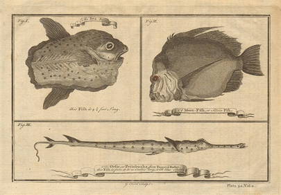
Ocean sunfish. Opah Moonfish. Orsie Petinbuaba Filefish. West African Fish 1745Jasper524.5(9.9k)See Sold PriceFeb 28, 2024
West African Fish. Filefish. Remora or suckerfish. Ocean Sunfish. SCHLEY 1747Jasper524.5(9.9k)See Sold PriceFeb 28, 2024
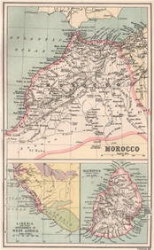
MOROCCO LIBERIA & MAURITIUS. Sierra Leone. BARTHOLOMEW 1886 old antique mapJasper524.5(9.9k)See Sold PriceFeb 28, 2024
West African Fish. Filefish. Remora or suckerfish. Ocean Sunfish 1747 printJasper524.5(9.9k)See Sold PriceFeb 28, 2024
West Africa. Hammerhead shark. Gambian insects. Ocean Sunfish. SCHLEY 1747Jasper524.5(9.9k)See Sold PriceFeb 28, 2024
COLONIAL GABON & CONGO. Afrique équatoriale française. Brazzaville plan 1938 mapJasper524.5(9.9k)See Sold PriceFeb 28, 2024
West Africa. Hammerhead shark. Gambian insects. Ocean Sunfish. Goosefish 1747Jasper524.5(9.9k)See Sold PriceFeb 28, 2024
Blackie (Pub) 1882 Folio Map. West USA - Pacific StatesAlbion Auctions4.6(341)See Sold PriceMar 01, 2024
James Cook - Antique map Australia titled 'Gezigt van het Eil. Suffren'. Antique map of SuffrenProverde Auctions4.3(3)See Sold PriceFeb 28, 2024