ATLAS of ANTIENT GEOGRAPHY by SAMUEL BUTLER 1843John McInnis Auctioneers,LLC4.5(505)See Sold PriceFeb 24, 2024
18TH C. ANTIQUE MAP: FRENCH & INDIAN WAR, FRAMEDThomaston Place Auction Galleries4.4(393)See Sold PriceFeb 24, 2024
Rand McNally Railroad Map Cabinet w/ 21 Railroad MapsRail & Road Auctions4.6(165)See Sold PriceMar 08, 2024
Keith Haring - Ink on New York Map, Best Buddies, Inscribed, Signed, and DatedSapphire Auction Gallery4(67)See Sold PriceMar 02, 2024
LATE 17TH C. FRENCH MAP OF THE NEW WORLD BY ALEXIS-HUBERT JAILLOT (1632-1712)Thomaston Place Auction Galleries4.4(393)See Sold PriceFeb 24, 2024
Central Railroad of New Jersey Map of Sandy Hook Route-ca. 1903JM Hobby Supply and Railroad Artifact Auctions4.4(127)See Sold PriceFeb 24, 2024
Lot of Six Mixed Atlas Box Cars-HO Scale-New in BoxJM Hobby Supply and Railroad Artifact Auctions4.4(127)See Sold PriceFeb 25, 2024
Rand McNally/Santa Fe Railroad Map of Iowa-1912JM Hobby Supply and Railroad Artifact Auctions4.4(127)See Sold PriceFeb 24, 2024
NICOLAES VISSCHER (NETHERLANDS, 1618-1709) MAP OF THE NEW WORLDThomaston Place Auction Galleries4.4(393)See Sold PriceFeb 24, 2024
17TH C. WORLD MAP BY NICOLAES VISSCHER (NETHERLANDS, 1618-1709)Thomaston Place Auction Galleries4.4(393)See Sold PriceFeb 24, 2024
Lot of Six Mixed Atlas Cabooses-HO Scale-New in BoxJM Hobby Supply and Railroad Artifact Auctions4.4(127)See Sold PriceFeb 25, 2024
Fisk & Co: Antique Map of Cook's Tours, Europe, 1882Title/Content of Map: Map[S] of Cook's Tours Date Printed: 1882 Cartographer: FISK & CO. Publisher: THOS. COOK & SON 1882 NEW YORK Size: Quarto Maps of Central Europe, England and Scotland, MediterranSee Sold Price
Map[S] of Cook's ToursPublication Date: 1882 Title: Map[S] of Cook's Tours Cartographer: FISK & CO. Publisher: THOS. COOK & SON Height: Width: Maps of Central Europe, England and Scotland, Mediterranean and the Levant, PalSee Sold Price
Rand McNally: Antique Map of Europe, 1882Title/Content of Map: 1882 Rand McNally Map of Europe -- Rand McNally & Company's Indexed Atlas of the World (Europe) Date Printed: 1882, Chicago Cartographer: Rand McNally Size: 13 X 19.4 A fantasticSee Sold Price
Desnos / de la Tour: Antique Map of Europe, 1771L' Europe Dressée pour L'etude de la Géographie Assujettie aux Observs. Astronomiques Par M. Brion Ingénieur-Géographe du Roy à Paris, chés le Sr. Desnos, I.G. pour les Globes et SphSee Sold Price
de la Tour: Antique Map of Turkey in Europe, 1771TITLE/CONTENT OF MAP: 'Turquie Européenne, avec les etats qui en sont tributaires, et les siéges des Eglises Chrétiennes qui y sont établis. Par M. Brion. Ingénieur-Géographe du Roi. à Paris, cSee Sold Price
Desnos/de la Tour: Antique Map of Turkey in EuropeTITLE/CONTENT OF MAP: 'Turquie Européenne, avec les etats qui en sont tributaires, et les siéges des Eglises Chrétiennes qui y sont établis. Par M. Brion. Ingénieur-Géographe du Roi. à Paris, cSee Sold Price
de la Tour: Antique Map of Russia in Europe, 1771TITLE/CONTENT OF MAP: 'La Russie Européenne, conformément à I'Atlas de cet Empire, et aux Mémoires les plus récens, avec ses Archevêchés et Evêchés Par. Mr. Brion Ingénieur Géographe du RoiSee Sold Price
SoldRand McNally: Antique Map of Europe, 1898Title/Content of Map: Europe Rand, McNally & Co.'S Indexed Atlas of the World Map of Europe. Date Printed: 1898 ca. Cartographer: RAND, MCNALLY & CO. Publisher: RAND, MCNALLY & COMPANY 1898 ca. CHICAGSee Sold Price
SoldAntique Kentucky / Tennessee Map by Hunt & Eaton, 1892Antique 19th Century Color Kentucky / Tennessee State Map | By Hunt & Eaton, New York | Engraved by Fisk & Co., N.Y. | Verso has populations by county of Kentucky and Tennessee | Approx. Size: Quarto-See Sold Price
Soldde la Tour: Antique Map of L'Europe, 1777Title/Content of Map: 'L'Europe' The map shows the Crimean Khanate, Sweden-Finland, and the Poland-Lithuanian Commonwealth. Date Printed: 1777. Image Size: Approx 18.5 x 16.5cm, 7.25 x 6.25 inches (MeSee Sold Price
de la Tour: Antique Map of Eastern Hemisphere, 1771TITLE/CONTENT OF MAP: 'Hémisphère Oriental' The Eastern Hemisphere: Africa, Europe, Asia, and a highly approximate representation of Australia DATE PRINTED: 1771 IMAGE SIZE: Approx 56.5 x 44.0cm, 22See Sold Price
de la Tour: Antique Map of Eastern Hemisphere, 1771Title/Content of Map: 'Hémisphère Oriental' The Eastern Hemisphere: Africa, Europe, Asia, and a highly approximate representation of Australia Date Printed: 1771 Image Size: Approx 56.5 x 44.0cm, 22See Sold Price
Sold19th c. Antique Rand McNally Atlas Map of EuropeLarge 19th Century Antique Atlas Map Entitled EUROPE | A historic map from published by Rand, McNally, Chicago, US, 1883 - "Rand, McNally & Co., Engr's, Chicago" | Matted as shown | Approx. DimensionsSee Sold Price
Rand McNally: Antique Map of Turkey in Europe, 1898Map: Turkey in Europe, Roumania, Servia, Bulgaria, and Montenegro Rand, McNally & Co.'S Indexed Atlas of the World Map of Turkey in Europe, Roumania, Bulgaria, And Montenegro Publication Date: 1898 AuSee Sold Price
Colton: Antique Map of Turkey in Europe, 1855Map: Colton's Turkey in Europe. | Colton's Turkey in Asia and the Caucasian Provinces of Russia. Publication Date: 1855 ca. Authors: J.H. COLTON & CO., COLTON, JOSEPH HUTCHINS Publisher: J.H. COLTON &See Sold Price
Tallis: Antique Map of Russia in Europe, 1865Map: Russia in Europe Publication Date: 1865 ca. Authors: JOHN TALLIS/THE LONDON PRINTING & PUBLISHING CO., TALLIS, JOHN Publisher: JOHN TALLIS/THE LONDON PRINTING & PUBLISHING CO. Size: Quarto – 11See Sold Price
SoldLett's POPULAR ATLAS EUROPE 1882 Large Color MapsTitle: Lett's Popular Atlas: Europe Publisher: Letts, Son & Co. Printing Year: 1882 Details/Condition: Bound in its original blindstamped emerald boards with gilt embossing, this book is a scarce porSee Sold Price
World as known to the Ancients. Europe Arabia SW Asia. BARTHOLOMEW 1882 mapTITLE OF MAP (NOT PRINTED ON THE PAGE):'The World as known to the Ancients' DATE PRINTED: 1882 IMAGE SIZE: Approx 31.0 x 43.0cm, 12.25 x 16.75 inches (Large) TYPE: Antique atlas map CONDITION: Good; sSee Sold Price
Turquie Européenne. Turkey in Europe. Balkans. DESNOS/DE LA TOUR 1771 mapTITLE OF MAP (NOT PRINTED ON THE PAGE):'Turkey in Europe' DATE PRINTED: 1870 IMAGE SIZE: Approx 29.0 x 40.5cm, 11.5 x 16 inches (Large) TYPE: Antique atlas map CONDITION: Good; suitable for framing. PSee Sold Price
Hardesty: Antique Atlas of Lawrence and Gallia Co, 1882Title/Content of Map: 1882 Hardesty Atlas of Lawrence and Gallia Co., Ohio and World -- Historical Hand-Atlas Illustrated, Containing Large Scale Copper Plate Maps of Each State… Together with ComplSee Sold Price
Antique Hardesty Atlas of Ohio and World, 1882Title/Content of Map: 1882 Hardesty Atlas of Lawrence and Gallia Co., Ohio and World -- Historical Hand-Atlas Illustrated, Containing Large Scale Copper Plate Maps of Each State… Together with ComplSee Sold Price
SoldCOOK'S TOURS ADVERTISING POSTER, EUROPEAN DESTINATIONSPoster depicts golden age of early tourism to 20th century Europe. Issued: 20th c. Dimensions: 28.5"W x 44"H, framed Manufacturer: S.C. Allen & Co. Country of Origin: EnglandSee Sold Price
SoldSeven antique books: A.E. Nordenskiold "The Voyage ofSeven antique books: A.E. Nordenskiold "The Voyage of the Vega Round Asia and Europe," 1882, 4 steel-engraved plates, 10 lithographed folding maps, 298 woodcut illustrations., Also includes three EdmoSee Sold Price
Antique 1882 Rockford Watch Co Size 18s Model 1 - 7J Pocket Watch Fahys Coin Silver CaseWestside Traders Emporium4.5(34)See Sold PriceFeb 27, 2024
Two (2) Antique 18th C. Copper Engraved Framed Maps - America & EuropeMagnusson Art Group4.5(53)See Sold PriceMar 14, 2024
William Simpson's Sketches at the Seat of War - Two Volumes with 81 Hand-colored LithographsTrillium Antique Prints & Rare Books4.5(32)See Sold PriceFeb 24, 2024
Carey, pub. 1796 - A Chart of the West IndiesTrillium Antique Prints & Rare Books4.5(32)See Sold PriceFeb 24, 2024
Carey, pub. 1796 - Map of GeorgiaTrillium Antique Prints & Rare Books4.5(32)See Sold PriceFeb 24, 2024
Carey, pub. 1796 - Map of The State of South CarolinaTrillium Antique Prints & Rare Books4.5(32)See Sold PriceFeb 24, 2024
Carey, pub. 1796 - Map of KentuckyTrillium Antique Prints & Rare Books4.5(32)See Sold PriceFeb 24, 2024
Carey, pub. 1796 - Map of the Tennassee State formerly part of North Carolina (Tennessee)Trillium Antique Prints & Rare Books4.5(32)See Sold PriceFeb 24, 2024
Pablo Picasso & Jean Cocteau's Picasso de 1916 ? 1961 - 24 LithographsTrillium Antique Prints & Rare Books4.5(32)See Sold PriceFeb 24, 2024
Mckenney & Hall - Two Octavo Volumes of Text with Rare Plate of Billy BowlegsTrillium Antique Prints & Rare Books4.5(32)See Sold PriceFeb 24, 2024
McKenney & Hall, Folio, Rare - 5 Native American LithographsTrillium Antique Prints & Rare Books4.5(32)See Sold PriceFeb 24, 2024
McKenney & Hall, Folio, Rare - Se-Quo-YahTrillium Antique Prints & Rare Books4.5(32)See Sold PriceFeb 24, 2024
McKenney & Hall, Folio, Rare - Hunting the BuffaloeTrillium Antique Prints & Rare Books4.5(32)See Sold PriceFeb 24, 2024
Rothschild, Extinct - Mauritius Blue Pigeon (Alectroenas Nitidissima). 22Trillium Antique Prints & Rare Books4.5(32)See Sold PriceFeb 24, 2024
Rothschild, Extinct - Ground Finch, Pink Pigeon, & Bonin Grosbeak (Geospiza Magnirostris, GeospizaTrillium Antique Prints & Rare Books4.5(32)See Sold PriceFeb 24, 2024
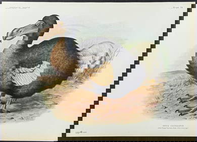
Rothschild, Extinct - Dodo Bird (Didus Cucculatus) with 3 Additional Outline PlatesTrillium Antique Prints & Rare Books4.5(32)See Sold PriceFeb 24, 2024
James Cook - Map of the Friendly Isles - Tonga IslandsProverde Auctions4.3(3)See Sold PriceFeb 28, 2024
Francis McNally - Antique Map of Ohio, Indiana & KentuckyProverde Auctions4.3(3)See Sold PriceFeb 28, 2024
ANTIQUE GRAND TOUR ITALIAN PIETRA DURA MOSAIC PICTUREAntique Arena Inc.4.5(878)See Sold PriceMar 09, 2024


![Map[S] of Cook's Tours (1 of 1)](https://p1.liveauctioneers.com/5584/180928/91034028_1_x.jpg?height=282&quality=70&version=1602020174)