ATLAS of ANTIENT GEOGRAPHY by SAMUEL BUTLER 1843John McInnis Auctioneers,LLC4.5(505)See Sold PriceFeb 25, 2024
18TH C. ANTIQUE MAP: FRENCH & INDIAN WAR, FRAMEDThomaston Place Auction Galleries4.4(393)See Sold PriceFeb 24, 2024
Rand McNally Railroad Map Cabinet w/ 21 Railroad MapsRail & Road Auctions4.6(165)See Sold PriceMar 08, 2024
Keith Haring - Ink on New York Map, Best Buddies, Inscribed, Signed, and DatedSapphire Auction Gallery4(67)See Sold PriceMar 02, 2024
LATE 17TH C. FRENCH MAP OF THE NEW WORLD BY ALEXIS-HUBERT JAILLOT (1632-1712)Thomaston Place Auction Galleries4.4(393)See Sold PriceFeb 24, 2024
Central Railroad of New Jersey Map of Sandy Hook Route-ca. 1903JM Hobby Supply and Railroad Artifact Auctions4.4(127)See Sold PriceFeb 24, 2024
Lot of Six Mixed Atlas Box Cars-HO Scale-New in BoxJM Hobby Supply and Railroad Artifact Auctions4.4(127)See Sold PriceFeb 25, 2024
Rand McNally/Santa Fe Railroad Map of Iowa-1912JM Hobby Supply and Railroad Artifact Auctions4.4(127)See Sold PriceFeb 24, 2024
NICOLAES VISSCHER (NETHERLANDS, 1618-1709) MAP OF THE NEW WORLDThomaston Place Auction Galleries4.4(393)See Sold PriceFeb 24, 2024
17TH C. WORLD MAP BY NICOLAES VISSCHER (NETHERLANDS, 1618-1709)Thomaston Place Auction Galleries4.4(393)See Sold PriceFeb 24, 2024
Lot of Six Mixed Atlas Cabooses-HO Scale-New in BoxJM Hobby Supply and Railroad Artifact Auctions4.4(127)See Sold PriceFeb 25, 2024
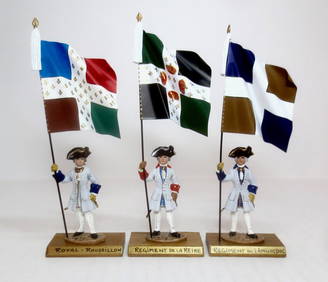
Santini/Bonne: Map of Languedoc, Foix & Roussillon 1784Title/Content of Map: 'Carte des Gouvernements de Languedoc, de Foix et de Roussillon avec la partie Orientale du Gouvernement de Guienne. Assujettie au Ciel Projettée par Mr. Bonne Me. de Mathémat.See Sold Price
Gouvernement General du Languedoc [...], Foix et Roussillon (Map of Languedoc, Foix and Roussillon)colored copper engraving map on paper, 1752, title decorated cartouche at the top left, miles pointer at the bottom right, map of the regions of Languedoc, Foix and Roussillon, published by Gilles andSee Sold Price
Li Governi di Linguadoca… di Rossiglione… Languedoc Roussillon. ZATTA 1779 mapTITLE/CONTENT OF MAP: 'Li Governi di Linguadoca, di Foix, e di Rossiglione con il Rouergue di nuova projezione' "The provinces of Languedoc, Foix, Roussillon and Rouergue". Southern France DATE PRINTESee Sold Price
Gouvernemens de Languedoc de Roussillon Occitanie.TITLE/CONTENT OF MAP: 'Gouvernemens de Languedoc de Roussillon, de Foix, et partie de celui de Guienne et Gascogne, avec les Généralités de Toulouse, de Montpelier, de Montauban, de Perpignan, et pSee Sold Price
Gouvernements de Languedoc, de Foix et de RoussillonTITLE/CONTENT OF MAP: 'Carte des Gouvernements de Languedoc, de Foix et de Roussillon avec la partie Orientale du Gouvernement de Guienne. Assujettie au Ciel Projettée par Mr. Bonne Me. de Mathémat.See Sold Price
Gouvernements de Languedoc, de Roussillon et de Foix.TITLE/CONTENT OF MAP: Gouvernements de Languedoc, de Roussillon et de Foix [The Provinces of Languedoc, Roussillon and Foix] DATE PRINTED: 1789 IMAGE SIZE: Approx 36.0 x 25.5cm, 14 x 10 inches (Large)See Sold Price
Gouvernements de Languedoc, de Roussillon et de Foix.TITLE/CONTENT OF MAP: Gouvernements de Languedoc, de Roussillon et de Foix [The Provinces of Languedoc, Roussillon and Foix] The top image on the right hand side shows the entire map. To view a closeSee Sold Price
RIGOBERT BONNE - LANGUEDOC, FOIX, ROUSSILLON, GUIENNE,Rigobert Bonne - Languedoc, Foix, Roussillon, Guienne, 1787 - 28 7/8 X 36 In. - Gallery Stretched The Piece Of Art Is Ready To Hang Or Lean Against A Wall, Or Display On An Easel. - A Giclée Print IsSee Sold Price
RIGOBERT BONNE - LANGUEDOC, FOIX, ROUSSILLON, GUIRigobert Bonne - Languedoc, Foix, Roussillon, Guienne, 1787 - Giclée On Canvas - 28 7/8 X 36 In.~~A giclée print falls between serigraph and lithograph in quality. Although they can be made on paperSee Sold Price
RIGOBERT BONNE - LANGUEDOC, FOIX, ROUSSILLON, GUIENNE,Rigobert Bonne - Languedoc, Foix, Roussillon, Guienne, 1787 - 28 7/8 X 36 In. - This Giclée Print Is Gallery Stretched And Ready To Hang Or Lean Against A Wall, Or Display On An Easel. - A Giclée PrSee Sold Price
RIGOBERT BONNE - LANGUEDOC, FOIX, ROUSSILLON, GUIENNE,Rigobert Bonne - Languedoc, Foix, Roussillon, Guienne, 1787 - 28 7/8 X 36 In. - This Giclée Print Is Gallery Stretched And Ready To Hang Or Lean Against A Wall, Or Display On An Easel. - A Giclée PrSee Sold Price
RIGOBERT BONNE - LANGUEDOC, FOIX, ROUSSILLON, GUIENNE,Rigobert Bonne - Languedoc, Foix, Roussillon, Guienne, 1787 - 28 7/8 X 36 In. - Gallery Stretched The Piece Of Art Is Ready To Hang Or Lean Against A Wall, Or Display On An Easel. - A Giclée Print IsSee Sold Price
RIGOBERT BONNE - LANGUEDOC, FOIX, ROUSSILLON, GUIENNE,RIGOBERT BONNE - LANGUEDOC, FOIX, ROUSSILLON, GUIENNE, 1787 - Giclée on Canvas 28 7/8 x 36 in.See Sold Price
LANGUEDOC, FOIX, ROUSSILLON, GUIENNE, 1787"RIGOBERT BONNE"LANGUEDOC, FOIX, ROUSSILLON, GUIENNE, 1787"24 x 30 in. This Giclée is high-resolution and of the highest quality, has a color permanence rating in excess of 100 years. Printed on CanvaSee Sold Price
SoldAntique Map of Languedoc-Roussillon in FrameAntique Map of Languedoc-Roussillon in Frame. Hand colored engraving of France, by the Spanish border. Showing the Mediterranean sea. Measures 21 x 15.5 inches.See Sold Price
Santini/Bonne: Antique Map of Burgundy, 1784TITLE/CONTENT OF MAP: 'Carte des Gouvernements de Bourgogne, de Franche Comté, et de Lyonnois Projettée et assujettie au Ciel, par Mr. Bonne Mtre. de Mathém. à Paris 1771. À Venise par P. SantiniSee Sold Price
Santini/Bonne: Antique Map of Dauphiny, 1784TITLE/CONTENT OF MAP: 'Carte des Gouvernements de Dauphiné et de Provence avec de Comtat Venaissin de la Principauté d'Orange Assujettie au Ciel et Projetté par M. Bonne Mtre de Mat. à Paris 1771.See Sold Price
Santini/Bonne: Antique Map of Guyenne & Gascony, 1784TITLE/CONTENT OF MAP: 'Carte du Governement de Guienne et Gascogne, avec celui de Bearn et Basse Navarre Projettée et assujettie au Ciel par M. Bonne Me. de M. à Paris 1771. À Venise par P. SantiniSee Sold Price
Santini/Bonne: Antique Map of West Africa, 1784TITLE/CONTENT OF MAP: 'Carte de la Guinée contenant les Isles du Cap Verd, le Senegal, la Côte de Gunée proprement dite, les Royaumes de Loango, Congo, Angola et Benguela, avec les Pays voisins autSee Sold Price
Santini / Bonne: Antique Map of Switzerland, 1784Title/Content of Map: 'La Suisse divisée en ses treize cantons et ses alliés Projettié et assujettie aux Observations Astronomiques par Mr. Bonne. À Venise par P. Santini 1778. Chez Mr. RemondiniSee Sold Price
Santini/Bonne: Antique Map of Champagne et Brie, 1784TITLE/CONTENT OF MAP: 'Carte du Gouvernement de Champagne et Brie Projettée et assujettie aux observations, par Mr. Bonne 1771. À Venise par P. Santini 1770. Chez Mr. Remondini [Map of the GovernmenSee Sold Price
Santini / Bonne: Antique Map of Lorraine & Alsace, 1784Title/Content of Map: 'Carte des Gouvernements de Lorraine et d' Alsace Projettée et assujettie au Ciel, par Mr. Bonne Me. de Mathem. À Venise par P. Santini 1777. Chez Mr. Remondini [Map of the GovSee Sold Price
France Vignobles. Languedoc Roussillon Provence Corse. SOPEXA/CNVF Wine map 1969Title: France Vignobles. Languedoc Roussillon Provence Corse. SOPEXA/CNVF Wine map 1969 Description: Les Vignobles de France - Languedoc - Roussillon - Côtes de Provence et Corse' by ComitéSee Sold Price
Santini / Bonne: Antique Map of Champagne et Brie, 1784Title/Content of Map: 'Carte du Gouvernement de Champagne et Brie Projettée et assujettie aux observations, par Mr. Bonne 1771. À Venise par P. Santini 1770. Chez Mr. Remondini [Map of the GovernmenSee Sold Price
Central Railroad of New Jersey Map of Sandy Hook Route-ca. 1903JM Hobby Supply and Railroad Artifact Auctions4.4(127)See Sold PriceFeb 24, 2024
Rand McNally/Santa Fe Railroad Map of Iowa-1912JM Hobby Supply and Railroad Artifact Auctions4.4(127)See Sold PriceFeb 24, 2024
LATE 17TH C. FRENCH MAP OF THE NEW WORLD BY ALEXIS-HUBERT JAILLOT (1632-1712)Thomaston Place Auction Galleries4.4(393)See Sold PriceFeb 24, 2024
18TH C. ANTIQUE MAP: FRENCH & INDIAN WAR, FRAMEDThomaston Place Auction Galleries4.4(393)See Sold PriceFeb 24, 2024
Keith Haring - Ink on New York Map, Best Buddies, Inscribed, Signed, and DatedSapphire Auction Gallery4(67)See Sold PriceMar 02, 2024
Rand McNally Railroad Map Cabinet w/ 21 Railroad MapsRail & Road Auctions4.6(165)See Sold PriceMar 08, 2024
Putnam - First Map of the State of Ohio by Rufus PutnamTrillium Antique Prints & Rare Books4.5(32)See Sold PriceFeb 24, 2024
La Nubia ed Abissinia. Red Sea Ethiopia Sudan Eritrea Arabia. ZATTA 1785 mapJasper524.5(9.9k)See Sold PriceFeb 28, 2024
POMPONIUS MELA 1784 ANTIQUE SCHOOL PRIMED VELLUM BINDING CLASSICAL LATIN WORKSNY Elizabeth 4.2(86)See Sold PriceMar 03, 2024
Robert Benard (1734 - 1777) - Set of 9 Copperplate Engravings - Greek and Roman architecture - ViewProverde Auctions4.3(3)See Sold PriceFeb 28, 2024
Robert Benard (1734 - 1777) - Set of 9 Copperplate Engravings - Architecture, Masonry, Quarry withProverde Auctions4.3(3)See Sold PriceFeb 28, 2024
Robert Benard (1734 - 1777) - Set of 9 Chemical Engravings - Alchemical symbols - Utensils forProverde Auctions4.3(3)See Sold PriceFeb 28, 2024
Denis Diderot (1713 - 1784) & Jean Le Rond d’Alembert (1717 - 1783) - Set of 10 Military Prints -Proverde Auctions4.3(3)See Sold PriceFeb 28, 2024


![Gouvernement General du Languedoc [...], Foix et Roussillon (Map of Languedoc, Foix and Roussillon) (1 of 2)](https://p1.liveauctioneers.com/6973/245658/127562816_1_x.jpg?height=282&quality=70&version=1650965339)