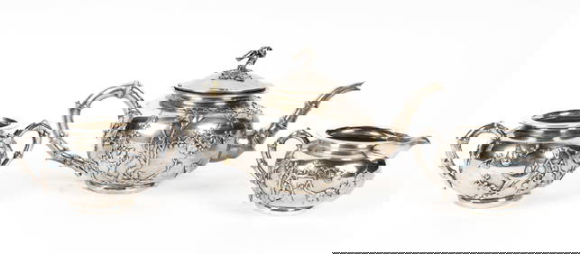
Sold''Mappe Monde,'' hemisphere map [ca. late 1700's][World]. Mappe Monde Ou Description Du Globe Terrestre. Double-page engraved maps, East and West Hemispheres. Paris: Lattre, c.1750. 7 1/8 x 10 inches. Map ''No. 5'' at upper right. Hand-coloring to mSee Sold Price
SoldGuillaume Delisle world mapCartographer: Guillaume Delisle Title: Mappe-Monde Dressee sur les Observations. Subject: World Published: Paris Date: 1700 Description: Double-hemisphere map of the world is the first edition in L'IsSee Sold Price
SoldGerard Valck Double-Hemisphere World MapGerard Valck Double-Hemisphere World Mapcopperplate engraving, MAPPE MONDE GEO HYDROGRAPHIQUE DU GLOBE, Amsterdam, late 17th century, hand-colored with allegorical scenes depicting each of the four seSee Sold Price
Mappe MondeTitle/Content of Map: Mappe Monde Date: 1840 ca. Cartographer: ANONYMOUS Size: Height - 3.8Width Publisher: Hemisphere world map from an unidentified French school atlas. Includes as rondelles moon phSee Sold Price
After Guillaume Delisle and Philippe BuacheAfter Guillaume Delisle (French, 1675-1726) and Philippe Buache (French, 1700-1773), "Mappemonde à Pufage du Roi", hand-colored double-hemisphere world map, 1785, with elaborate banner cartouche andSee Sold Price
SoldAfter Delisle and Buache, 1785 Wold MapAfter Guillaume Delisle (French, 1675-1726) and Philippe Buache (French, 1700-1773), "Mappemonde à Pufage du Roi", hand-colored double-hemisphere world map, 1785, with elaborate banner cartouche andSee Sold Price
Sold[BRUÉ, ADRIEN HUBERT] A lot of 26 maps[BRUÉ, ADRIEN HUBERT] 26 maps. Approx. 39cm x 56.9cm (15.25" x 22.5") plate mark; 52.8cm x 66.5cm (20.75" x 26.25") sheet. Ca. 1820.Mappe-Monde En Deux Hemisphères ** Carte Générale Des Iles BritaSee Sold Price
SoldMappe Monde, sur un Plan Horisontal, situé à 45d.Rigobert Bonne?, Mappe Monde, sur un Plan Horisontal, situé à 45d. de Latitude Nord. Hemisphere Oriental., engraving, late 18th century, 14.5 x 10 14.5 x 10See Sold Price
1875 Mappe-Monde Hemisphere Map“Mappe-Monde en Deux Hemispheres”, printed at Paris 1875, by Migeon, Fine, central fold. Measures 19 x 13.5”. Please note that this lot has a confidential reserve. When you leave a bid in advancSee Sold Price
Antique Felix Delamarche Vaugondy Mappemonde Double hemisphere world map 1838Charles-Francois Delamarche (1740-1817), the founder of the family firm was one of the most important French geographers and mapmakers of the second half of the eighteenth century. Successor to NicolaSee Sold Price
Antique Felix Delamarche Vaugondy Mappemonde Double hemisphere world map 1838Charles-Francois Delamarche (1740-1817), the founder of the family firm was one of the most important French geographers and mapmakers of the second half of the eighteenth century. Successor to NicolaSee Sold Price
Antique Felix Delamarche Vaugondy Mappemonde Double hemisphere world map 1838Charles-Francois Delamarche (1740-1817), the founder of the family firm was one of the most important French geographers and mapmakers of the second half of the eighteenth century. Successor to NicolaSee Sold Price
SoldHomann (Heirs of) Planiglobii TerrestrisHomann (Heirs of) Planiglobii Terrestris, Mappe-Monde,double-hemisphere world map, with polar projections above and below, 2 other circular projections in the lower corners, title cartouches iSee Sold Price
Homann (Heirs of) Planiglobii Terrestris, Mappe-MoHomann (Heirs of) Planiglobii Terrestris, Mappe-Monde,double-hemisphere world map, with polar projections above and below, 2 other circular projections in the lower corners, title cartouches iSee Sold Price
SoldRobert De Vaugondy (Didier) Mappe-MondeRobert De Vaugondy (Didier) Mappe-Monde,double-hemisphere world map, large decorative title cartouche with garlands, centre above, with smaller Avertissement cartouche suspended from a ribbonSee Sold Price
World.- Menetrier (F.) Le Petit Journal Mappemonde,World.- Menetrier (F.) Le Petit Journal Mappemonde, double-hemisphere world map, issued as a special supplement to the French newspaper Le Petit Journal, with shipping routes and sailing times to destSee Sold Price
SoldVuillemin (Alexandre) MappemondeVuillemin (Alexandre) Mappemonde,double-hemisphere world map with title above and planetary system below, engraved map with original hand-colouring, 475 x 750mm., three vertical folds, spottinSee Sold Price
SoldVuillemin (Alexandre) MappemondeVuillemin (Alexandre) Mappemonde,twin-hemisphere world map with small planetory sphere, lower centre, engraved map with original hand-colouring, 375 x 740mm., 3 vertical folds, a few creases rSee Sold Price
SoldVuillemin (Alexandre) MappemondeVuillemin (Alexandre) Mappemonde,twin-hemisphere world map with small planetary sphere, lower centre, engraved map with original hand-colouring, 375 x 740mm., 3 vertical folds, a few creases rSee Sold Price
Cubes, Wuerfel Puzzle "Mappemonde en deux Hemispheres"Cubes, Wuerfel Puzzle "Mappemonde en deux Hemispheres" ca 1880, France, Pappmache, Okt, schoener OriginalzustandSee Sold Price
Antique Hemisphere Maps, MappeMonde Projetee Sur LPair of Antique Hemisphere Maps, MappeMonde Projetee Sur L\'Horizon de Paris et de Son Antipode & MappeMonde sur La Projection Polaire by Adrien Hubert Brue (1786-1832) | Date 1875 | Cartes dressees pSee Sold Price
Mappemonde en Deux Hemispheres World Map 2 HemispheresMappemonde en Deux Hemispheres\' | ARTIST: Conrad Malte-Brun | DATE: c. 1846 | SIZE: Map with borders: Approx. 16\" H x 22\" W (40.64 x 55.88cm); image only: Approx. 11\" H x 18.5\" W (28.0 x 47.5cm)See Sold Price
Mappemonde en Deux Hemispheres World Map 2 HemispheresTITLE: 'Mappemonde en Deux Hemispheres' | ARTIST: Conrad Malte-Brun | DATE: c. 1846 | SIZE: Map with borders: Approx. 16" H x 22" W (40.64 x 55.88cm); image only: Approx. 11" H x 18.5" W (28.0 x 47.5cSee Sold Price
SoldF.A. GARNIER TWIN HEMISPHERE WORLD MAP, 1860Map no. 13, titled 'Tableau Spheroidal de la Terre, Ou Mappemonde en Deux Hemispheres.' Inset maps below. Printed in Paris. Professionally matted and framed in archival material. 37.75 x 43 inches oveSee Sold Price
Antique Collins and Fairbanks Beaver Fur Top Hat and Hat Case Late 1700sCowboy Joe's Antiques4.7(189)See Sold PriceFeb 27, 2024
LARGE LATE 17TH C. DUTCH CHART OF CANADA, GREAT LAKES, NEW FRANCE, LABRADOR, HUDSON BAY, BY PIERREThomaston Place Auction Galleries4.4(386)See Sold PriceFeb 24, 2024
COVENS & MORTIER 1745 MAP OF THE GLOBEThomaston Place Auction Galleries4.4(386)See Sold PriceFeb 24, 2024
EARLY 18TH C. MAP OF ITALY, FRAMEDThomaston Place Auction Galleries4.4(386)See Sold PriceFeb 24, 2024
LATE 16TH C. MAP OF SCOTLAND BY MERCATOR, FRAMEDThomaston Place Auction Galleries4.4(386)See Sold PriceFeb 24, 2024
Three Akan Tribal Brass African Containers Forowa Boxes and a Dan Snuff MortarArarity Auctions4.6(166)See Sold PriceMar 03, 2024
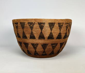
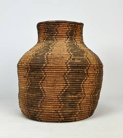
Antique Native American Woven Basket Possibly ApacheArarity Auctions4.6(166)See Sold PriceMar 03, 2024
[AMERICANA]. A Photo Album of Nearly 125 Albumen or Silver ...Potter & Potter Auctions4.6(539)See Sold PriceMar 07, 2024
[SHEET MUSIC]. A Group of Nearly 57 Sheet Music Pieces and ...Potter & Potter Auctions4.6(539)See Sold PriceMar 07, 2024
[HOLIDAY CARDS]. A Huge Group of Nearly 400 Color Holiday C...Potter & Potter Auctions4.6(539)See Sold PriceMar 07, 2024
[BLACK PANTHER PARTY]. Black is Beautiful poster. [With:] Photographic essays, incl. The VanguardFreeman's | Hindman4.4(1.6k)See Sold PriceFeb 27, 2024
[EARLY PHOTOGRAPHY]. A large collection of assorted photographs of African American vernacularFreeman's | Hindman4.4(1.6k)See Sold PriceFeb 27, 2024
[ENSLAVEMENT & ABOLITION]. Anti-slavery "Am I Not a Man and a Brother?" token.Freeman's | Hindman4.4(1.6k)See Sold PriceFeb 27, 2024
Four octagonal vials made of gold ruby glassDr. Fischer Fine Art Auctions4.5(109)See Sold PriceMar 09, 2024


![''Mappe Monde,'' hemisphere map [ca. late 1700's] First Image](https://p1.liveauctioneers.com/179/17501/5894421_1_x.jpg?height=282&quality=95&version=1225486369&width=282)
![''Mappe Monde,'' hemisphere map [ca. late 1700's] (1 of 1)](https://p1.liveauctioneers.com/179/17501/5894421_1_x.jpg?height=282&quality=70&version=1225486369)
![''Mappe Monde,'' hemisphere map [ca. late 1700's] First Image](https://p1.liveauctioneers.com/179/17501/5894421_1_x.jpg?height=282&quality=1&version=1225486369&width=282)


![[BRUÉ, ADRIEN HUBERT] A lot of 26 maps (1 of 1)](https://p1.liveauctioneers.com/1124/187577/94368850_1_x.jpg?height=282&quality=70&version=1607095126)


![[AMERICANA]. A Photo Album of Nearly 125 Albumen or Silver ... (1 of 4)](https://p1.liveauctioneers.com/928/318880/171361214_1_x.jpg?height=282&quality=70&version=1707501302)
![[SHEET MUSIC]. A Group of Nearly 57 Sheet Music Pieces and ... (1 of 1)](https://p1.liveauctioneers.com/928/318880/171361496_1_x.jpg?height=282&quality=70&version=1707501302)
![[HOLIDAY CARDS]. A Huge Group of Nearly 400 Color Holiday C... (1 of 1)](https://p1.liveauctioneers.com/928/318880/171361539_1_x.jpg?height=282&quality=70&version=1707501302)
![[BLACK PANTHER PARTY]. Black is Beautiful poster. [With:] Photographic essays, incl. The Vanguard (1 of 8)](https://p1.liveauctioneers.com/197/319238/171467899_1_x.jpg?height=282&quality=70&version=1707520367)
![[EARLY PHOTOGRAPHY]. A large collection of assorted photographs of African American vernacular (1 of 5)](https://p1.liveauctioneers.com/197/319238/171467963_1_x.jpg?height=282&quality=70&version=1707520367)
![[ENSLAVEMENT & ABOLITION]. Anti-slavery "Am I Not a Man and a Brother?" token. (1 of 2)](https://p1.liveauctioneers.com/197/319238/171468074_1_x.jpg?height=282&quality=70&version=1707520367)