MATTHEWS c1856 Map Of Upper Canada Ontario Indian Land Agency Divisions Scarce!Luis Porretta Fine Arts4.3(10)See Sold PriceMar 02, 2024
DEVINE c1856 Dr Salters Map Of Lake Huron Ontario Indian Lands etc. No. 7 ScarceLuis Porretta Fine Arts4.3(10)See Sold PriceMar 02, 2024
DUNLEVIE c1856 Map Counties Of Gaspe & Bonaventure Quebec Canada SCARCE! #1Luis Porretta Fine Arts4.3(10)See Sold PriceMar 02, 2024
DUNLEVIE c1856 Map Counties Of Gaspe & Bonaventure Quebec Canada SCARCE! #2Luis Porretta Fine Arts4.3(10)See Sold PriceMar 02, 2024
Map UNITED COUNTIES LEEDS & GRENVILLE by Walling 1861 Rare Canada Map 5ft x 5ftLuis Porretta Fine Arts4.3(10)See Sold PriceMar 02, 2024
Ambroise TARDIEU c1822 Map Venice Napoleon Italian Campaign 17" x 11"Luis Porretta Fine Arts4.3(10)See Sold PriceMar 02, 2024
PanAm: Vintage Pictorial Map of North America, 1967Title/Content of Map: 1967 PanAm Pictorial Map of North America -- Amerique du Nord et Centrale Date Printed: 1967 Cartographer: J Liozu / PanAm Size: 8.1 x 5.6 in. Two very attractive pictorial mapsSee Sold Price
PanAm: Vintage Pictorial Map of North America, 1967Map: 1967 PanAm Pictorial Map of North America -- Amerique du Nord et Centrale Cartographer: J Liozu / PanAm Year / Place: 1966 Map Dimensions: 8.1 x 5.6 in. Condition: Excellent. Nice, sharp image anSee Sold Price
PanAm: Vintage Pictorial Map of North America, 1967Title/Content of Map: 1967 PanAm Pictorial Map of North America -- Amerique du Nord et Centrale Date Printed: 1967 Cartographer: J Liozu / PanAm Size: 8.1 x 5.6 in. Two very attractive pictorial mapsSee Sold Price
1967 PanAm Pictorial Map of North America -- AmeriqueTitle/Content: 1967 PanAm Pictorial Map of North America -- Amerique du Nord et Centrale Cartographer: J Liozu / PanAm Year/Place: 1967 Size: 8.1 x 5.6 in. Description: Two very attractive pictorial mSee Sold Price
1967 PanAm Pictorial Map of North America -- AmeriqueTitle/Content of Map: 1967 PanAm Pictorial Map of North America -- Amerique du Nord et Centrale Cartographer: J Liozu / PanAm Year/Place: 1967 Size: 8.1 x 5.6 in. Two very attractive pictorial maps ofSee Sold Price
1967 PanAm Pictorial Map of North America -- AmeriqueTitle/Content of Map: 1967 PanAm Pictorial Map of North America -- Amerique du Nord et Centrale Date: 1967 Cartographer: J Liozu / PanAm Size: 8.1 x 5.6 in. Two very attractive pictorial maps of NorthSee Sold Price
1967 PanAm Pictorial Map of North America -- AmeriqueTitle/Content of Map: 1967 PanAm Pictorial Map of North America -- Amerique du Nord et Centrale Date: 1967 Cartographer: J Liozu / PanAm Size: 8.1 x 5.6 in. Two very attractive pictorial maps of NorthSee Sold Price
1967 PanAm Pictorial Map of North America -- AmeriqueTitle/Content of Map: 1967 PanAm Pictorial Map of North America -- Amerique du Nord et Centrale Date: 1967 Cartographer: J Liozu / PanAmSize: 8.1 x 5.6 in. Two very attractive pictorial maps of NorthSee Sold Price
1967 PanAm Pictorial Map of North America -- AmeriqueTitle/Content of Map: 1967 PanAm Pictorial Map of North America -- Amerique du Nord et Centrale Date: 1967 Cartographer: J Liozu / PanAm Size: 8.1 x 5.6 in. Two very attractive pictorial maps of NorthSee Sold Price
1967 PanAm Pictorial Map of North America -- AmeriqueReserve Reduced! Title/Content of Map: 1967 PanAm Pictorial Map of North America -- Amerique du Nord et Centrale Date: 1967 Cartographer: J Liozu / PanAm Size: 8.1 x 5.6 in. Two very attractive pictorSee Sold Price
SoldPanAm Vintage Pictorial Map of Australia & Oceania 1960Title/Content of Map: 1960 PanAm Pictorial Map of Australia and Oceania -- Australie Oceanie Date Printed: 1960 Cartographer: J Liozu / PanAm Size: 11.8 x 9 in. Very attractive pictorial map of AustraSee Sold Price
SoldPanAm: Vintage Pictorial Map of Asia, 1960Map: 1960 PanAm Pictorial Map of Asia -- Asiae Cartographer: J Liozu / PanAm Year / Place: 1960 Map Dimensions: 11.8 x 9 in. Condition: Very Good. Nice, sharp image and colors.Later center-fold. VerySee Sold Price
SoldPanAM: Vintage Pictorial World Map, 1957Title/Content of Map: 1957 PanAM Pictorial World Map -- Your Clipper Cargo Market Area Date Printed: 1957 c. Cartographer: PanAm Size: 22 x 34 in. A very interesting world map showing PanAm cargo routSee Sold Price
SoldVINTAGE REPRO MAP NORTH AMERICA IN 1700 BY DELISLEVintage Rand McNally reproduction map of North American from printed maps in the Library of Congress originally drawn by Guillaume DeLisle in 1700 A.D. It is in good condition with small puncture 0.5See Sold Price
SoldVINTAGE REPRO MAP NORTH AMERICA IN 1700 BY DELISLEVintage Rand McNally reproduction map of North American from printed maps in the Library of Congress originally drawn by Guillaume DeLisle in 1700 A.D. It is in good condition with small puncture 0.5See Sold Price
Sharp and clean vintage map of North America, Mitchell 1860Beautiful map of North America showing the entire continent along with Greenland, Central America, the West Indies and Iceland. Shows the routes of various arctic explorers. Mitchell’s unique flSee Sold Price
VINTAGE REPRO MAP NORTH AMERICA IN 1700 BY DELISLEVintage Rand McNally reproduction map of North American from printed maps in the Library of Congress originally drawn by Guillaume DeLisle in 1700 A.D. It is in good condition with small puncture 0.5See Sold Price
VINTAGE REPRO MAP NORTH AMERICA IN 1700 BY DELISLEVintage Rand McNally reproduction map of North American from printed maps in the Library of Congress originally drawn by Guillaume DeLisle in 1700 A.D. It is in good condition with small puncture 0.5See Sold Price
VINTAGE REPRO MAP NORTH AMERICA IN 1700 BY DELISLEVintage Rand McNally reproduction map of North American from printed maps in the Library of Congress originally drawn by Guillaume DeLisle in 1700 A.D. It is in good condition with small puncture 0.5See Sold Price
VINTAGE REPRO MAP NORTH AMERICA IN 1700 BY DELISLEVintage Rand McNally reproduction map of North American from printed maps in the Library of Congress originally drawn by Guillaume DeLisle in 1700 A.D. It is in good condition with small puncture 0.5See Sold Price
SoldTWO VINTAGE MAPS OF NORTH AMERICA & CALIFORNIATWO VINTAGE MAPS OF NORTH AMERICA & CALIFORNIA. NORTH AMERICAN PUBLISHED: A.T.C. BLACK EDINBURGH, CALIFORNIA & UTAH, 1860: AUGUSTUS MITCHELL. Height: 24 in. by Width: 18 in. by Depth: 1 in.See Sold Price
Vintage 1860s school atlas map of North AmericaNice clean vintage map of North America with full, original hand coloring. Most of British Possessions labeled as “Hudson Bay Territory.” Canada denoted as minor part of upper North AmericSee Sold Price
SoldOriginal Vintage Advertising Poster North Africa LucienOriginal vintage pictorial map of North Africa: French Union, featuring color coded list of agencies and a coat of Arms on upper right corner - Credit Lyonnais Fonde en 1863, Afrique du Nord, Union FrSee Sold Price
VINTAGE 1944 MAP OF NORTH AMERICAVINTAGE 1944 MAP OF NORTH AMERICA **|**|** AUTHENTIC 1944 MAP OF NORTH AMERICA 9" X 12" #42925v2See Sold Price
5 Dollars - Elizabeth II Map of North AmericaWeatherham Estate Treasures3.9(157)See Sold PriceMar 07, 2024
U.S. Official Pictures of the World War 1920North American Artifact Auctions4.6(182)See Sold PriceApr 20, 2024
3 Hardback Train Books. Trains in Transition, THE NORTHERN PACIFIC Main Street of the NorthwestNorth American Artifact Auctions4.6(182)See Sold PriceApr 20, 2024
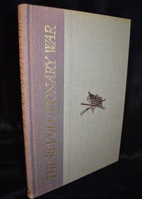
The Revolutionary War (America's Fight for Freedom) 1967 Fine or Near FineNorth American Artifact Auctions4.6(182)See Sold PriceApr 20, 2024
The Art of Hunting Big Game in North America 1967North American Artifact Auctions4.6(182)See Sold PriceApr 20, 2024
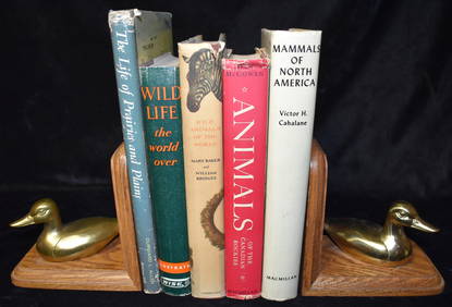
5 Mid-Century Books on Animals all in Excellent Condition.North American Artifact Auctions4.6(182)See Sold PriceApr 20, 2024
5 Hardback Books about the West & Old West in Excellent condition w/ Dust CoversNorth American Artifact Auctions4.6(182)See Sold PriceApr 20, 2024
5 Books About the Old West in Excellent Condition Hardbacks w/ DustcoversNorth American Artifact Auctions4.6(182)See Sold PriceApr 20, 2024
A Field Guide To Wildflowers, Birds & Birds Nesting 3 Books from the Peterson Field Guide SeriesNorth American Artifact Auctions4.6(182)See Sold PriceApr 20, 2024
Arrowsmith & Lewis - Map of North AmericaTrillium Antique Prints & Rare Books4.5(30)See Sold PriceFeb 24, 2024
Map: An 18thC engraved and hand coloured map of North America and South America, titled DeClaydon Auctioneers Ltd4.3(125)See Sold PriceFeb 26, 2024
New and Correct Map of North America With the West India Islands,Jasper524.5(9.8k)See Sold PriceFeb 27, 2024
Italian edition of Sanson's map of North America, 1677PBA Galleries4.7(381)See Sold PriceMar 07, 2024