ATLAS of ANTIENT GEOGRAPHY by SAMUEL BUTLER 1843John McInnis Auctioneers,LLC4.6(502)See Sold PriceFeb 24, 2024
18TH C. ANTIQUE MAP: FRENCH & INDIAN WAR, FRAMEDThomaston Place Auction Galleries4.4(386)See Sold PriceFeb 24, 2024
Rand McNally Railroad Map Cabinet w/ 21 Railroad MapsRail & Road Auctions4.6(165)See Sold PriceMar 08, 2024
Keith Haring - Ink on New York Map, Best Buddies, Inscribed, Signed, and DatedSapphire Auction Gallery4(67)See Sold PriceMar 02, 2024
LATE 17TH C. FRENCH MAP OF THE NEW WORLD BY ALEXIS-HUBERT JAILLOT (1632-1712)Thomaston Place Auction Galleries4.4(386)See Sold PriceFeb 24, 2024
Central Railroad of New Jersey Map of Sandy Hook Route-ca. 1903JM Hobby Supply and Railroad Artifact Auctions4.4(126)See Sold PriceFeb 24, 2024
Lot of Six Mixed Atlas Box Cars-HO Scale-New in BoxJM Hobby Supply and Railroad Artifact Auctions4.4(126)See Sold PriceFeb 25, 2024
Rand McNally/Santa Fe Railroad Map of Iowa-1912JM Hobby Supply and Railroad Artifact Auctions4.4(126)See Sold PriceFeb 24, 2024
NICOLAES VISSCHER (NETHERLANDS, 1618-1709) MAP OF THE NEW WORLDThomaston Place Auction Galleries4.4(386)See Sold PriceFeb 24, 2024
17TH C. WORLD MAP BY NICOLAES VISSCHER (NETHERLANDS, 1618-1709)Thomaston Place Auction Galleries4.4(386)See Sold PriceFeb 24, 2024
Lot of Six Mixed Atlas Cabooses-HO Scale-New in BoxJM Hobby Supply and Railroad Artifact Auctions4.4(126)See Sold PriceFeb 25, 2024
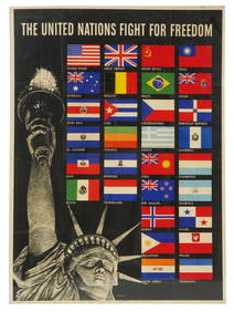
Colton: Antique Map of Flags of All Nations, 1868Scarce Colton’s Flags of All Nations in fine condition, 1868. Beautiful example of Colton’s National & Commercial Flags of All Nations. Colton chart showing the flags of the World. Includes MarryaSee Sold Price
SoldScarce Colton’s Flags of Nations - fine cond., 1868Reserve Reduced! Beautiful example of Colton’s “National & Commercial Flags of All Nations.” Colton chart showing the flags of the World. Includes Marryats code of Commercial signals, British AdSee Sold Price
SoldThree American Maps, pub. J.H. ColtonA Group of Three Antique American Maps, 1852-1854, published by J.H. Colton, No. 86 Cedar St., New York, comprised of "Chart of National Flags", "Map of North America", and "The World", 19 1/2 in. x 2See Sold Price
COLTON AND FITCHS MODERN SCHOOL GEOGRAPHY, 1863 AND 18681863 and 1868. New York. Iverson, Phinney and Blakeman, Publisher. Two volumes that are used, antique school books. Each has 40 maps and numerous engravings. , LOT REF #23-615See Sold Price
SoldColton: Antique Map of Boston, 1861Title/Content of Map: Boston by Colton Date Printed: 1861 Cartographer: J.H. Colton Material/Medium: Paper Size: 14" x 17 1/4" Hand colored, steel engraved. From Colton's 'General Atlas'. Published inSee Sold Price
SoldColton: Antique Map of Mountains & Rivers, 1869Premium example of Colton’s Mountains & Rivers, 1869 (undated). Gorgeous and clean large format example of the Colton mountains and rivers plate, showing the lengths of the principal rivers of the wSee Sold Price
SoldColton: Antique Map of New Jersey, 1859Title/Content of Map: New Jersey by Colton Date Printed: 1859 Cartographer: H.J. Colton Material/Medium: Paper Size: 17 1/2" x 15" Hand colored,engraved. Published in New York in 'Colton's General AtlSee Sold Price
SoldColton: Antique Map of United States of America, 1864Map: Colton's United States of America. Unusual Idaho Includes Colored, Un-named Montana and Wyoming - Rare Publication Date: 1864 Authors: J.H. COLTON, COLTON, JOSEPH HUTCHINS Publisher: J.H. COLTONSee Sold Price
SoldColton: Antique Map of Vermont, 1859Title/Content of Map: Vermont by Colton Date Printed: 1859 Cartographer: H.J. Colton Material/Medium: Paper Size: 17 1/2" x 15" Hand colored,engraved. Published in New York in 'Colton's General Atlas.See Sold Price
SoldColton: Antique Map of West Indies, 1859Title/Content of Map: West Indes by Colton Date Printed: 1859 Cartographer: H.J. Colton Material/Medium: Paper Size: 17 1/2" x 14 1/2" Hand colored engraved Map. Publsihed in New York in 'Colton's GenSee Sold Price
SoldColton: Antique Map of Cuba Jamaica & Puerto Rico, 1861Map: Cuba, Jamaica & Puerto Rico Date Printed: 1861 Cartographer: J.H. Colton Material/Medium: Paper Size: 17 1/2" x 14" Condition: Excellent. Small tear near top center and lower left. Tear does notSee Sold Price
SoldColton: Antique Map of Southern Italy, 1857Title: Map of Southern Italy by Colton Date: 1857 Dimensions (inches): 17 x 14 Medium: Hand Colored Lithograph Condition: Small rips along bottom and right side Joseph Hutchins Colton (1800 - 1893), kSee Sold Price
SoldColton: Antique Map of London, 1859Title/Content of Map: London by Colton Date Printed: 1859 Cartographer: H.J. Colton Material/Medium: Paper Size: 17 1/2" x 15" Hand colored,engraved. Published in New York in 'Colton's General Atlas.'See Sold Price
SoldColton: Antique Map of Kingdom of Naples, 1861Title/Content of Map: Southern Itay Kingdom of Naples insert of Malta Date Printed: 1861 Cartographer: J. H. Colton Material/Medium: Paper Size: 17" x 14" Hand colored, steel engraved. From Colton's 'See Sold Price
Colton: Antique Map of the Western United States, 1876Map: 1876 Colton Folding Map of the Western United States -- Colton's Map of the States and Territories West of the Mississippi River to the Pacific Ocean Showing the Overland Routes, Projected Rail RSee Sold Price
SoldColton: Antique Map of Japan, 1861Map: Japan Date Printed: 1861 Cartographer: J. H. Colton Material/Medium: Paper Size: Approx 17 1/2" x 14 1/4" Condition: Excellent Hand colored, steel engraved. From Colton's General Atlas New York.See Sold Price
SoldColton: Antique Map of Southern Italy, 1855Title/Content of Map: 1855 Colton's Southern Italy -- Southern Italy Kingdom of Naples, I. Sardinia & Malta Date Printed: 1855, New York Cartographer: J Colton Size: 13 X 15.5 in. A very attractive maSee Sold Price
SoldColton: Antique Map of Cuba, 1859Title/Content of Map: Cuba by Colton Date Printed: 1859 Cartographer: H. J. Colton Material/Medium: Paper Size: 17 1/2" x 15" Hand colored engraved. Published in New York in 'Colton's General Atlas'.See Sold Price
Colton: Antique Map of Texas, 1859Title/Content of Map: Texas by Colton 1859 Date Printed: 1859 Cartographer: H. J. Colton Material/Medium: Paper Size: 30" x 17 1/2" Hand colored, engraved. Published in New York in Colton's 'General ASee Sold Price
SoldColton: Antique Map of Chicago & St. Louis, 1859Title/Content of Map: Chicago & St. Louis by Colton Date Printed: 1859 Cartographer: H. J. Colton Material/Medium: Paper Size: 17 1/2" x 15" Hand colored engraved. Published in New York in 'Colton's GSee Sold Price
SoldColton: Antique Map of Mississippi, 1871Title/Content of Map: Colton's Mississippi Date Printed: 1871 Cartographer: G. W. Colton Material/Medium: Paper Size: 13" x 17" Hand colored lithograph. From 'Colton's American Atlas.' Published in NeSee Sold Price
SoldColton: Antique Map of North America, 1859Title/Content of Map: North America by Colton Date Printed: 1859 Cartographer: H.J. Colton Material/Medium: Paper Size: 17 1/2" x 15" Hand colored, engraved Map. Published in New York in Colton's 'GenSee Sold Price
SoldColton: Antique Map of Texas, 18641860 Colton’s Texas - uncommon. From an 1864 school atlas. This map is not seen very often. Delineates all counties to 1860. Shows topography, forts, railroads, battle fields, rivers, etc. �See Sold Price
SoldColton: Antique Map of North Carolina, 1859Title/Content of Map: North Carolina Date Printed: 1859 Cartographer: H.J. Colton Material/Medium: Paper Size: 17 1/2" x 15" Hand colored,engraved. Published in New York in 'Colton's General Atlas.' PSee Sold Price
17TH C. ANTIQUE MAP SIEGE OF LA ROCHELLE, FRANCE, FRAMEDThomaston Place Auction Galleries4.4(386)See Sold PriceFeb 24, 2024
18TH C. ANTIQUE MAP: FRENCH & INDIAN WAR, FRAMEDThomaston Place Auction Galleries4.4(386)See Sold PriceFeb 24, 2024
Putnam - First Map of the State of Ohio by Rufus PutnamTrillium Antique Prints & Rare Books4.5(30)See Sold PriceFeb 24, 2024
Mitchell - Map of the City of Washington (Washington, DC)Trillium Antique Prints & Rare Books4.5(30)See Sold PriceFeb 24, 2024
Carey, pub. 1796 - Map of the Tennassee State formerly part of North Carolina (Tennessee)Trillium Antique Prints & Rare Books4.5(30)See Sold PriceFeb 24, 2024
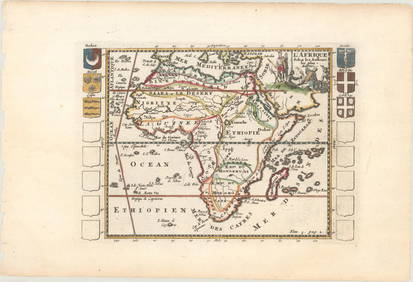
De Jode, Rare, pub. 1593 - Map of Africa (Africae Vera Forma, et Situs)Trillium Antique Prints & Rare Books4.5(30)See Sold PriceFeb 24, 2024
1738 RUSSIA SIBERIA & GREAT TARTARY Description illustrated ANTIQUE in ENGLISHJasper524.5(9.8k)See Sold PriceFeb 27, 2024
COLONIAL AFRICA Afrique. League of Nations Mandates. Ethnicity 1938 old mapJasper524.5(9.8k)See Sold PriceFeb 28, 2024
West Africa. Liberia Sahara Senegambia Guinea. Mountains of Kong COLTON 1869 mapJasper524.5(9.8k)See Sold PriceFeb 28, 2024
North west Africa. Liberia inset. Sahara Senegambia Guinea. COLTON 1863 mapJasper524.5(9.8k)See Sold PriceFeb 28, 2024
COLONIAL AFRICA Afrique. League of Nations Mandates. Ethnicity 1929 old mapJasper524.5(9.8k)See Sold PriceFeb 28, 2024
COLONIAL AFRICA Afrique. League of Nations Mandates. Ethnicity 1931 old mapJasper524.5(9.8k)See Sold PriceFeb 28, 2024
NORTH AFRICAN FLAGS. Tripoli Tunis Algiers. Libya Tunisia Algeria. HOUNSELL 1873Jasper524.5(9.8k)See Sold PriceFeb 28, 2024
Cooke, George 1801 Antique Map. United States of AmericaAlbion Auctions4.6(336)See Sold PriceMar 01, 2024
1792 OLD INDIA HISTORY ANTIQUE ILLUSTRATED WITH MAPS OF THE EIGHTEENTH CENTURY IN FRENCHNY Elizabeth 4.3(84)See Sold PriceMar 03, 2024
Francis McNally - Antique Map of Ohio, Indiana & KentuckyProverde Auctions4.3(3)See Sold PriceFeb 28, 2024
Antique Map of Poland, 1700 by Guillaume De Lisle, ParisAntiques Online Auctions4.6(407)See Sold PriceMar 14, 2024