ATLAS of ANTIENT GEOGRAPHY by SAMUEL BUTLER 1843John McInnis Auctioneers,LLC4.5(505)See Sold PriceFeb 24, 2024
18TH C. ANTIQUE MAP: FRENCH & INDIAN WAR, FRAMEDThomaston Place Auction Galleries4.4(393)See Sold PriceFeb 24, 2024
Rand McNally Railroad Map Cabinet w/ 21 Railroad MapsRail & Road Auctions4.6(165)See Sold PriceMar 08, 2024
Keith Haring - Ink on New York Map, Best Buddies, Inscribed, Signed, and DatedSapphire Auction Gallery4.1(67)See Sold PriceMar 02, 2024
LATE 17TH C. FRENCH MAP OF THE NEW WORLD BY ALEXIS-HUBERT JAILLOT (1632-1712)Thomaston Place Auction Galleries4.4(393)See Sold PriceFeb 24, 2024
Central Railroad of New Jersey Map of Sandy Hook Route-ca. 1903JM Hobby Supply and Railroad Artifact Auctions4.4(127)See Sold PriceFeb 24, 2024
Lot of Six Mixed Atlas Box Cars-HO Scale-New in BoxJM Hobby Supply and Railroad Artifact Auctions4.4(127)See Sold PriceFeb 25, 2024
Rand McNally/Santa Fe Railroad Map of Iowa-1912JM Hobby Supply and Railroad Artifact Auctions4.4(127)See Sold PriceFeb 24, 2024
NICOLAES VISSCHER (NETHERLANDS, 1618-1709) MAP OF THE NEW WORLDThomaston Place Auction Galleries4.4(393)See Sold PriceFeb 24, 2024
17TH C. WORLD MAP BY NICOLAES VISSCHER (NETHERLANDS, 1618-1709)Thomaston Place Auction Galleries4.4(393)See Sold PriceFeb 24, 2024
Lot of Six Mixed Atlas Cabooses-HO Scale-New in BoxJM Hobby Supply and Railroad Artifact Auctions4.4(127)See Sold PriceFeb 25, 2024
SoldA map of Flanders, Hondius, first half of the 17thC,A map of Flanders, Hondius, first half of the 17thC, 39,5 x 50 cm; added a folio of an 18thC English travel guide, 17 x 22 cm; extra added (Musin A.), a view on the Ostend harbor, watercolour, dated 1See Sold Price
Jodocus Hondius after Mercator "Saxoniae superiorJodocus Hondius after Mercator "Saxoniae superioris Lusatiae Misniaeque descriptio". First half 17. century. Engraving map with two cartridges. Inscribed "Milliaria Germanica" in one of the cartridge.See Sold Price
Three old military infantry maps. First half of 20th ceThree old military infantry maps. First half of 20th century. Among others: Rhenen 1939. Nijmegen and Nijmegen 1934. From 11th Regiment Commander 38. Size: 11 x 25.5 x 0.5 cm. (close).See Sold Price
SoldHawaiian Islands Handbook of Information 1899Title: The Hawaiian Islands: A Hand Book of Information Issued by the Department of Foreign Affairs, Honolulu, 1899 Author: ** Description: Unpaginated. Title page + 2-page map + first half of book isSee Sold Price
Calendar from an illuminated manuscript Book of HoursCalendar from an illuminated manuscript Book of Hours, in Latin on parchment [Low Countries or French Flanders, first half of the fifteenth century] Six leaves, entries in an angular bookhand of high-See Sold Price
[Cartography - Europe and Asia] Group of 18 Assorted[Cartography - Europe and Asia] Group of 18 Assorted Maps, First Half 20th Century 18 assorted maps, from 1909 to 1946. Includes tourist maps of Budapest, London and Paris. Maps of both WWI and WWII.See Sold Price
SoldShipton (Eric) Blank on the MapShipton (Eric) Blank on the Map,first edition, half-title, frontispiece, plates, folding map, original boards, dust-jacket, repaired tear to lower panel, slighly creased at edges, [Neate S58;See Sold Price
SoldUnsigned, the resurrection of Lazarus, first half ofUnsigned, the resurrection of Lazarus, first half of 17thC, oil on panel, 47,5 x 69,5 cmSee Sold Price
SoldChesney.Exped..Survey..Euphrates & TigrisChesney (Francis Rawdon) The Expedition for the Survey of the Rivers Euphrates and Tigris,vol.1 & 2 (all published) but without the slip-case of maps, first edition, half-titles, 49 tinted litSee Sold Price
SoldA first half of the 17thC Flemish richly oak carvedA first half of the 17thC Flemish richly oak carved cupboard with ebony inlay, H 230 - W 165 - D 70 cmSee Sold Price
Sold'The Last Supper', after Leonardo Da Vinci, copper'The Last Supper', after Leonardo Da Vinci, copper engraving by P. Soutman, first half of the 17thC, 29 x 99,4 cmSee Sold Price
SoldMAP OF MASSACHUSETTS Titled upper right marginMAP OF MASSACHUSETTS First Half of the 19th CenturySee Sold Price
SoldUnsigned (attributed to Snayers P.), the ambush, oil onUnsigned (attributed to Snayers P.), the ambush, oil on panel, first half of the 17thC, 48,5 x 66 cmSee Sold Price
SoldUnsigned (attributed to Snayers P.), the ambush, oil onUnsigned (attributed to Snayers P.), the ambush, oil on panel, first half of the 17thC, 48,5 x 66 cmSee Sold Price
SOUTHERN FLANDERS OR FRENCH SCHOOL, FIRST HALF 17THOil on canvas.With flaws.96.2 x 72.2 cm; 101 x 78 cm (frame).See Sold Price
SoldBlaeu Map of Virginia, 1640BLAEU, Willem Janszoon (1571-1638). Nova Virginiae Tabula. Engraved map with original color in full. Amsterdam, c. 1640. 20" x 23" sheet. This Map by Hondius was the first version of Smith's map of thSee Sold Price
SoldNova Virginiae TabulaHenricus Hondius (1573-1650). Engraved map with original hand color in full. Amsterdam, 1640. 20 x 23 1/2 inches sheet, 29 1/2 x 32 3/4 inches framed. This Map by Hondius was the first version of SmitSee Sold Price
Map of Bermuda, by Hondius 1633 (first edition)Original copper engraving by Hondius, 1633. Unique as settlers divided property into tribes based on the gentleman on ship that landed there. Dimensions: 23 1/2" x 27 3/4" Shipping Domestic: ShippingSee Sold Price
Map of Bermuda, by Hondius 1633 (first edition)Original copper engraving by Hondius, 1633. Unique as settlers divided property into tribes based on the gentleman on ship that landed there. (Dimensions: 23 1/2" x 27 3/4") Shipping Domestic: ShippinSee Sold Price
Colored Map of Palestine. Ze'ev Raban, First Half ofColored map of Palestine by Ze'ev Raban. First half of the twentieth century. Map demarcates large cities in Israel and Transjordan– Jerusalem, Haifa, Gaza, Akeiva etc. Colored illustrations. TSee Sold Price
SoldAmerica.- Washington (George) Letters from HisAmerica.- Washington (George) Letters from His Excellency General Washington, to Arthur Young, Esq. F.R.S. Containing an account of his husbandry, with a map of his farm, first edition, half-title, enSee Sold Price
SoldThe Story of the Malakand Field Force, first editi( Sir Winston) The Story of the Malakand Field Force, first edition, first issue without the errata slip preceding first folding map, half-title, frontispiece portrait, 6 maps including 2 colour andSee Sold Price
SoldChurchill.Story..Malakand Field Force,1st,1898Churchill (Sir Winston) The Story of the Malakand Field Force,first edition, first issue without the errata slip preceding first folding map, half-title, frontispiece portrait, 6 maps includinSee Sold Price
ChurchillChurchill The Story of the Malakand Field Force, first edition, second state with the errata slip preceeding the first folding map, half-title with ink ownership inscription to head, frontispiSee Sold Price
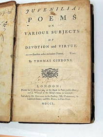
Thomas Gibbons Juvenalia 1750 Very Rare 1st Edition Full CalfLuis Porretta Fine Arts4.3(10)See Sold PriceMar 02, 2024
JAN VAN DER DESYATER c1732 First Edition Thoughts On Sleepless Nights Rare!Luis Porretta Fine Arts4.3(10)See Sold PriceMar 02, 2024
RARE 1638 HONDIUS MAP OF BERMUDA, FRAMEDThomaston Place Auction Galleries4.4(393)See Sold PriceFeb 24, 2024
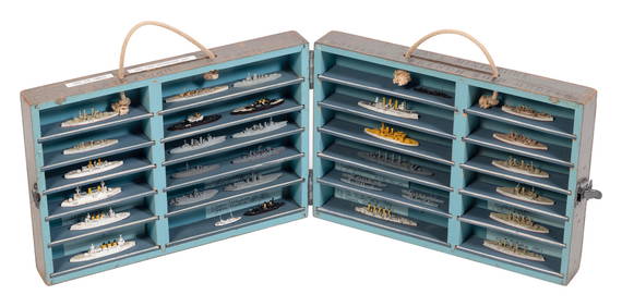
CASED SET OF SHIP RECOGNITION/TEACHING MODELS First Half of the 20th Century Model lengths fromEldred's4.7(419)See Sold PriceFeb 27, 2024
William Simpson's Sketches at the Seat of War - Two Volumes with 81 Hand-colored LithographsTrillium Antique Prints & Rare Books4.5(32)See Sold PriceFeb 24, 2024
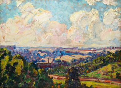
ILLEGIBLY SIGNED (FIRST HALF 20TH CENTURY) "SUMMER LANDSCAPE".Amelia Jeffers, Auctioneers & Appraisers4.5(120)See Sold PriceMar 07, 2024
Foulis.- Corsica.- Boswell (James) An Account of Corsica, the journal of a tour to that island; andForum Auctions4.3(53)See Sold PriceFeb 29, 2024
First World War.- Petre (F.Loraine), Wilfrid Ewart & Major General Lowther. The Scots Guards in theForum Auctions4.3(53)See Sold PriceFeb 29, 2024
Emory's Notes of a Military Reconnoissance larger issuePBA Galleries4.7(385)See Sold PriceMar 07, 2024


![[Cartography - Europe and Asia] Group of 18 Assorted (1 of 4)](https://p1.liveauctioneers.com/46/113409/58240974_1_x.jpg?height=282&quality=70&version=1512492316)