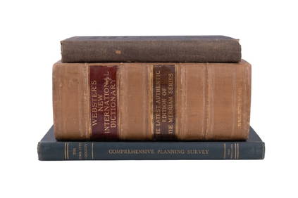
ATLAS of ANTIENT GEOGRAPHY by SAMUEL BUTLER 1843John McInnis Auctioneers,LLC4.6(502)See Sold PriceFeb 24, 2024
18TH C. ANTIQUE MAP: FRENCH & INDIAN WAR, FRAMEDThomaston Place Auction Galleries4.4(386)See Sold PriceFeb 24, 2024
Rand McNally Railroad Map Cabinet w/ 21 Railroad MapsRail & Road Auctions4.6(165)See Sold PriceMar 08, 2024
Keith Haring - Ink on New York Map, Best Buddies, Inscribed, Signed, and DatedSapphire Auction Gallery4(67)See Sold PriceMar 02, 2024
LATE 17TH C. FRENCH MAP OF THE NEW WORLD BY ALEXIS-HUBERT JAILLOT (1632-1712)Thomaston Place Auction Galleries4.4(386)See Sold PriceFeb 24, 2024
Central Railroad of New Jersey Map of Sandy Hook Route-ca. 1903JM Hobby Supply and Railroad Artifact Auctions4.4(126)See Sold PriceFeb 24, 2024
Lot of Six Mixed Atlas Box Cars-HO Scale-New in BoxJM Hobby Supply and Railroad Artifact Auctions4.4(126)See Sold PriceFeb 25, 2024
Rand McNally/Santa Fe Railroad Map of Iowa-1912JM Hobby Supply and Railroad Artifact Auctions4.4(126)See Sold PriceFeb 24, 2024
NICOLAES VISSCHER (NETHERLANDS, 1618-1709) MAP OF THE NEW WORLDThomaston Place Auction Galleries4.4(386)See Sold PriceFeb 24, 2024
17TH C. WORLD MAP BY NICOLAES VISSCHER (NETHERLANDS, 1618-1709)Thomaston Place Auction Galleries4.4(386)See Sold PriceFeb 24, 2024
Lot of Six Mixed Atlas Cabooses-HO Scale-New in BoxJM Hobby Supply and Railroad Artifact Auctions4.4(126)See Sold PriceFeb 25, 2024
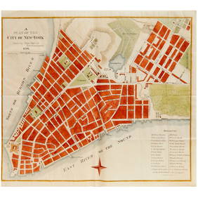
Plan of the City of New York Drawn from Actual SurveyPlan of the City of New York Drawn from Actual Survey by Casimir Th. Goerck and Joseph Fr. Mangin, City Surveyor. . . New York, Nov. 1856 . Nov. 1856Joseph Francois Mangin / Casimir Goerck / Richard CSee Sold Price
Sold[Plan of New York City] 1856[Plan of New York City], "Plan of the City of New York, Drawn from the Actual Survey by Casimir Goerck and Joseph Mangin, City Surveyor", 1856, engraved from the original 1803 map for Valentine's ManuSee Sold Price
[Plan of New York City][Plan of New York City], "Plan of the City of New York, Drawn from the Actual Survey by Casimir Goerck and Joseph Mangin, City Surveyor", 1856, engraved from the original 1803 map for Valentine's ManuSee Sold Price
SoldPlan of New York City Engraved Map 1856[Plan of New York City], "Plan of the City of New York, Drawn from the Actual Survey by Casimir Goerck and Joseph Mangin, City Surveyor", 1856, engraved from the original 1803 map for Valentine's ManuSee Sold Price
SoldA Plan of the City of New York by James LyneA Plan of the City of New York from an actual Survey, made By Hames Lyne, measuring 18.5 by 23.25 inches.See Sold Price
SoldLithograph Map, New York , James LyneUnframed hand colored lithograph map, ''A Plan of the City of New York from an Actual Survey,'' 19th century, after James Lyne, overall: 18''h x 23''wSee Sold Price
MAP OF THE CITY OF NEW YORKA Plan of the City of New York from an Actual Survey made by James Lyne" by Charles Magnus, mounted in hand illustrated mat, American, ca. 1850 (framed); 16 1/2" x 22See Sold Price
Sold19th C. Plan of the city of New York from an actual19th C. - A plan of the city of New York from an actual survey Known as the Bradford Plan. By James Lyne and Publisher:New-York : Pubed. by G. Hayward. Notes: Facsimile of an original map [New York :See Sold Price
SoldBardford Map of New YorkA Plan of The City of New York from an actual Survey (Late 19th Century facsimile of the "Governor Bradford map" of New York City, 1728). With 5 accompanying maps. Lithographed map. Dimensions varySee Sold Price
SoldMagnus's 1850 Litho of the 1728 Bradford Map NYCColonial AmericaMagnus’s 1850s Litho of the 1728 “Bradford Map” of New York City c. 1850, “A Plan of the City of New York from an Actual Survey,” By Charles Magnus, afterSee Sold Price
SoldBradford, William (after)Lyne, James American (18th/19th century) A PLAN OF THE CITY OF NEW YORK FROM AN ACTUAL SURVEY, 1728 print on paper, framed sight size: 16 1/2 x 21 1/2 inches *Note: An American early 19th century FedeSee Sold Price
. 19th C. Plan of the city of New York from an actual19th C. - A plan of the city of New York from an actual survey Known as the Bradford Plan. By James Lyne and Publisher:New-York : Pubed. by G. Hayward. Notes: Facsimile of an original map [New York :See Sold Price
Plan of the City of New York - Survey 1763A Plan of the City of New York Reduced From An Actual Survey By T Maerfchatekm, 1763 Copy from the original map in the possession of John F. Seaman, Esq. Map has chain lines and partial wateSee Sold Price
A Plan of the City of New York CityA Plan of the City of New York City from an actual Survey. Hand-colored print, approx. 17.75 x 22.5 in. (sight), framed and glazed. Lower margin at left: Printed for D.T. Valentine's History of New YSee Sold Price
SoldAtlas of Worcester County Massachusetts from Actual SurAtlas of Worcester County Massachusetts from Actual Surveys. New York: F.W. Beers & Co., 1870. Folio, with ninety-five colored town and village plans of the fifty-eight cities and towns in Worcester cSee Sold Price
SoldAtlas of the City of New YorkRepublished by G.W. Bromley and Co. Inc. 325 Spring street New York 13, NY 1957. Borough of Manhattan Volume II. From actual surveys and official plans. Portfolio size 23 1/4 x 19 1/2 inches. Note: ReSee Sold Price
SoldPLAT BOOK OF CITY OF ROCHESTER 1926 Hopkins AtlasTitle: Plat Book of the City of Rochester, New York. From Official Records, Private Plans and Actual Surveys Compiler and Publisher: G. M. Hopkins Co. Civil Engineers Printing Year: 1926 Condition/DeSee Sold Price
SoldPlan of the City and Suburbs of New Orleans"Plan of the City and Suburbs of New Orleans; from An Actual Survey Made in 1815", by Jacques Tanesse, facsimile published Ithaca, New York: Historic Urban Plans, 1967, after the original published bySee Sold Price
SoldJacques Tanesse Map of New Orleans, 1817Jacques Tanesse (New Orleans), "Plan of the City and Suburbs of New Orleans from an Actual Survey made in 1815 by J. Tanesse, City Surveyor", 1817, engraving, drawn by Jacques Tanesse, engraved by WilSee Sold Price
SoldJacques Tanesse (New Orleans)Jacques Tanesse (New Orleans), "Plan of the City and Suburbs of New Orleans from an Actual Survey made in 1815 by J. Tanesse, City Surveyor", 1825, engraving, drawn by Jacques Tanesse, engraved by WilSee Sold Price
SoldHand-Colored ANTIQUE LINEN-BACKED WALL MAP OFDetails: This lot consists of the antique wall map shown in the corresponding images.This map of Montgomery County, New York, was drawn from actual surveys done by Samuel Geil and B.J. Hunter. It wasSee Sold Price
SoldThree 19th Century Maps of New YorkGroup Lot of 3 New York Maps 1. Map of the City of New York, 1852. D. T. Valentine (1801 - 1869). New York: Hayward, 1852. Lithograph. Dimensions. 2. Plan of the City of New-York, drawn by Major HollaSee Sold Price
SoldMontresor, Plan of City of New YorkMONTRESOR, John (1736-1799). A Plan of the City of New-York & its Environs Survey'd in the Winter, 1775. Engraved map by P. Andrews. London: A. Dury, 1775. 29 1/4" x 22" sheet, 40" x 33" framed. RARESee Sold Price
SoldMONTRESOR, John (1736-1799). A Plan of the City of New-MONTRESOR, John (1736-1799). A Plan of the City of New-York & its Environs… Survey’d in the Winter, 1775. London: A. Dury, [1775]. Hand-colored copper-engraved map with inset plan of New York HarbSee Sold Price
IRVING WOLFSON, American, Etching Post Office New York City, New York, Pencil SignedDonny Malone Auctions4.5(1.7k)See Sold PriceMar 04, 2024
Pair of The Gateway to a Continent Books - Grand Central Zone and 1939 World's FairRail & Road Auctions4.6(165)See Sold PriceMar 07, 2024
ALBERT BACKUS - SEWALL'S POINT - PAINTING - OIL ON CANVAS - IN THE STYLE OFThe Art's World4.3(1)See Sold PriceFeb 27, 2024
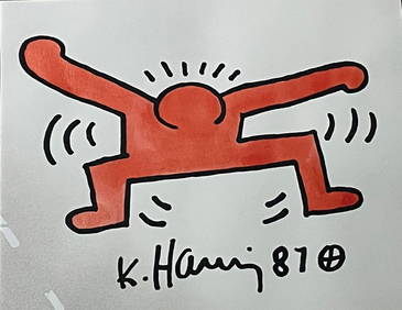
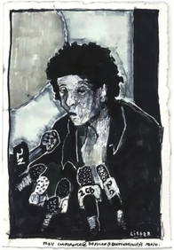
KEITH HARING - POP ART RED FIGURE – ACRYLIC ON PAPER - IN THE STYLE OFThe Art's World4.3(1)See Sold PriceFeb 27, 2024
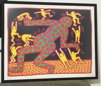
KEITH HARING - ANDY MOUSE - PAINTING - ACRYLIC ON CANVAS - IN THE STYLE OFThe Art's World4.3(1)See Sold PriceFeb 27, 2024
KEITH HARING - THE FERTILITY 3 SUITE – LITHOGRAPHY ON PAPER - SIGNED AND MARKED EA - IN THEThe Art's World4.3(1)See Sold PriceFeb 27, 2024
The Human Body by Logan Clendening 1930North American Artifact Auctions4.6(182)See Sold PriceApr 20, 2024
Our Trees: How to Know Them by Clarence Weed 1946North American Artifact Auctions4.6(182)See Sold PriceApr 20, 2024
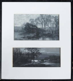
Hugh Bolton Jones (Maryland/New York, 1848-1927), "View of the Woods," early 20th c., together withCrescent City Auction Gallery4.3(229)See Sold PriceMar 01, 2024
A Chinese famille rose 'figural' vase, 19th centuryOakridge Auction Gallery4.5(190)See Sold PriceMar 16, 2024


![[Plan of New York City] 1856 (1 of 1)](https://p1.liveauctioneers.com/268/73491/37942439_1_x.jpg?height=282&quality=70&version=1434055136)
![[Plan of New York City] (1 of 1)](https://p1.liveauctioneers.com/268/66578/33775886_1_x.jpg?height=282&quality=70&version=1421356890)