ATLAS of ANTIENT GEOGRAPHY by SAMUEL BUTLER 1843John McInnis Auctioneers,LLC4.5(505)See Sold PriceFeb 24, 2024
18TH C. ANTIQUE MAP: FRENCH & INDIAN WAR, FRAMEDThomaston Place Auction Galleries4.4(393)See Sold PriceFeb 24, 2024
Rand McNally Railroad Map Cabinet w/ 21 Railroad MapsRail & Road Auctions4.6(165)See Sold PriceMar 08, 2024
Keith Haring - Ink on New York Map, Best Buddies, Inscribed, Signed, and DatedSapphire Auction Gallery4(67)See Sold PriceMar 02, 2024
LATE 17TH C. FRENCH MAP OF THE NEW WORLD BY ALEXIS-HUBERT JAILLOT (1632-1712)Thomaston Place Auction Galleries4.4(393)See Sold PriceFeb 24, 2024
Central Railroad of New Jersey Map of Sandy Hook Route-ca. 1903JM Hobby Supply and Railroad Artifact Auctions4.4(127)See Sold PriceFeb 24, 2024
Lot of Six Mixed Atlas Box Cars-HO Scale-New in BoxJM Hobby Supply and Railroad Artifact Auctions4.4(127)See Sold PriceFeb 25, 2024
Rand McNally/Santa Fe Railroad Map of Iowa-1912JM Hobby Supply and Railroad Artifact Auctions4.4(127)See Sold PriceFeb 24, 2024
NICOLAES VISSCHER (NETHERLANDS, 1618-1709) MAP OF THE NEW WORLDThomaston Place Auction Galleries4.4(393)See Sold PriceFeb 24, 2024
17TH C. WORLD MAP BY NICOLAES VISSCHER (NETHERLANDS, 1618-1709)Thomaston Place Auction Galleries4.4(393)See Sold PriceFeb 24, 2024
Lot of Six Mixed Atlas Cabooses-HO Scale-New in BoxJM Hobby Supply and Railroad Artifact Auctions4.4(127)See Sold PriceFeb 25, 2024
Bradford: Antique Map fo Siberia and Central Asia, 1835Title/Content of Map: Siberia and Central Asia Date Printed: 1835 Cartographer: T.G. Bradford Material/Medium: Paper Size: 19" x 10" A Comprehensive Atlas Geographical, Historical & Commercial. PublisSee Sold Price
SoldBradford: Antique Map of Siberia & Central Asia, 1835Map: Siberia & Central Asia Date Printed: 1835 Cartographer: T.G. Bradford Material/Medium: Paper Size: 13" x 9 1/2" Condition: Very Good. Some foxing on edges. Does not affect Map. Hand colored outliSee Sold Price
Bradford: Antique Map of Northern China, 1835Title/Content of Map: Northern China with Mongolia and Siberia, Central Asia to Korea Date Printed: 1835 Cartographer: T.G. Bradford Material/Medium: Paper Size: 13" x 10" Condition: Excellent Hand coSee Sold Price
Bradford: Map of Siberia & Central Asia, 1835Title: Siberia & Central Asia Publication Date: 1835 Authors: AMERICAN STATIONERS COMPANY, BRADFORD, THOMAS GAMALIEL Publisher: AMERICAN STATIONERS COMPANY Size: Quarto – 7.75 H x 10.00 W Inches MapSee Sold Price
Bradford: Map of Siberia & Central Asia, 1835Map: Siberia & Central Asia Publication Date: 1835 Authors: WM. D. TICKNOR, BRADFORD, THOMAS GAMALIEL Publisher: WM. D. TICKNOR Size: Quarto – 7.75 H x 10.00 W Inches Polar projection. 124. EngravedSee Sold Price
SoldSiberia & Central Asia by BradfordSiberia & Central Asia by Bradford 1835 T.G. Bradford 10" x 13" A Comprehensive Atlas Geographical, Historical & Commercial. Published in Boston. Hand colored outlines First edition of the first issueSee Sold Price
Sold4 Bradfords antique maps4 Bradfords antique maps- ''Siberia and Central Asia''; ''Asia''; ''Southern Asia'' and ''China and Japan''- with hand-coloring, various sizes.See Sold Price
Bradford: Antique Map of Northern Asia, 1835Map: Northern Asia Date Printed: 1835 Cartographer: T.G. Bradford Material/Medium: Paper Size: 13" x 10" Condition: Excellent Hand colored outlines. First edition and first issue of the first AmericanSee Sold Price
SoldSDUK: Antique Map of Central Asia & Siberia, 1846Title/Content of Map: 'WESTERN SIBERIA, INDEPENDENT TARTARY, KHIVA, BOKHARA &c' Date Printed: 1846 Image Size: Approx 42.0 x 34.5cm, 16.5 x 13.75 inches (Large) Type: Antique steel engraved map with oSee Sold Price
Johnston: Antique Map of Russia in Asia, Siberia, 1897Title/Content of Map: 'Russia in Asia; Inset map of Continuation South-West' Siberia. Central Asia. Caspian Sea Irkutsk Date Printed: 1897 Image Size: Approx 20.5 x 27.0cm, 8.25 x 10.5 inches (Medium)See Sold Price
NORTH & CENTRAL ASIA. Siberia Japan Korea Khiva Bukhara Turkistan 1901 old mapTITLE/CONTENT OF MAP: 'Northern Asia; Central Asia' DATE PRINTED: 1901 IMAGE SIZE: Approx 43.0 x 33.0cm, 17 x 13 inches (Large); Please note that this is a folding map. TYPE: Antique colour map CONDITSee Sold Price
RUSSIA IN ASIA'. Siberia. WELLER, c1865 antique mapTITLE/CONTENT OF MAP: 'Russia in Asia' The map shows Russia east of the Ural Mountains including much of central Asia DATE PRINTED: c1865 IMAGE SIZE: Approx 48.0 x 64.5cm, 18.75 x 25.25 inches (Large)See Sold Price
RUSSIA IN ASIA'. Siberia. WELLER, c1865 antique mapTITLE/CONTENT OF MAP: 'Russia in Asia' The map shows Russia east of the Ural Mountains including much of central Asia DATE PRINTED: c1865 IMAGE SIZE: Approx 48.0 x 64.5cm, 18.75 x 25.25 inches (Large)See Sold Price
NORTH & CENTRAL ASIA. Siberia Japan Korea Khiva Bokhara Turkistan 1912 old mapTITLE/CONTENT OF MAP: 'Northern Asia; Central Asia' DATE PRINTED: 1912 IMAGE SIZE: Approx 33.0 x 44.0cm, 13 x 17.25 inches (Large); Please note that this is a folding map. TYPE: Antique colour atlas mSee Sold Price
CENTRAL ASIA. Western Siberia, Khiva Bokhara. Independent Tartary. SDUK 1846 mapTITLE/CONTENT OF MAP: 'WESTERN SIBERIA, INDEPENDENT TARTARY, KHIVA, BOKHARA &c' DATE PRINTED: 1846 IMAGE SIZE: Approx 42.0 x 34.5cm, 16.5 x 13.75 inches (Large) TYPE: Antique steel engraved map with oSee Sold Price
CENTRAL ASIA. Western Siberia, Khiva Bokhara.TITLE/CONTENT OF MAP: 'WESTERN SIBERIA, INDEPENDENT TARTARY, KHIVA, BOKHARA &c' DATE PRINTED: 1846 IMAGE SIZE: Approx 42.0 x 34.5cm, 16.5 x 13.75 inches (Large) TYPE: Antique steel engraved map with oSee Sold Price
CENTRAL ASIA. Western Siberia, Khiva Bokhara. Independent Tartary. SDUK 1846 mapTITLE/CONTENT OF MAP: 'WESTERN SIBERIA, INDEPENDENT TARTARY, KHIVA, BOKHARA &c' DATE PRINTED: 1846 IMAGE SIZE: Approx 42.0 x 34.5cm, 16.5 x 13.75 inches (Large) TYPE: Antique steel engraved map CONDITSee Sold Price
Siberia & Central AsiaTitle: Siberia & Central Asia Publication Date: 1835 Cartographer: Bradford, T.G. Publisher: William D. Ticknor Size: 7.75Height - 10Width Polar projection. 124. Engraved by G.W. Boynton? Margin spotsSee Sold Price
Arrowsmith: Antique Map of Asia Minor, 1842Map: Map of Asia Minor to Illustrate the Journeys of W.I. Hamilton Esqr. 1835-1837 Compiled from Original Documents by John Arrowsmith Publication Date: 1842-11-01 Cartographer: ARROWSMITH, JOHN PubliSee Sold Price
SoldBellin: Antique Maps of Central Asia / Silk Road, 1749Map: 1. Carte de Karazm, Turkestan et Grande Bukarie. 2. Carte de la Petite Bukharie et Pays Voisin Cartographer: Jacques Nicolas Bellin Place & Date: Paris / 1749/1760 Size: 12" x 8 1/2" (each) CondiSee Sold Price
Homann Heirs: Antique Map of Central Asia, 1739Map: Imperii Rusici Et Tartariae Universae... Opera Ioh. Mathiae Hasu, Math. P.P. ... Publication Date: 1739 Cartographer: DORN, SEBASTIAN Publisher: HOMANN HEIRS Size: Folio – 21.00 H x 24.00 W IncSee Sold Price
Stanford: Antique Map Of Central Asia, 1896TITLE/CONTENT OF MAP: 'Central Asia' Trans-Caspian Aral Sea Khiva Bokhara Sirdaria DATE PRINTED: 1896 IMAGE SIZE: Approx 36.0 x 50.0cm, 14 x 19.75 inches (Large); Please note that this is a folding maSee Sold Price
Bonne: Antique Map of Central Asia, 1780TITLE/CONTENT OF MAP: 'Carte de la Perse, de la Géorgie, et de la Tartarie Indépendante' A map of Central and southwest Asia; "Independent Tartary", Tibet, Persia, the Caspian Sea, Persia, Iraq, theSee Sold Price
Stanford: Antique Map of Central Asia, 1896Title/Content of Map: 'Central Asia' Trans-Caspian Aral Sea Khiva Bokhara Sirdaria Date Printed: 1896 Image Size: Approx 36.0 x 50.0cm, 14 x 19.75 inches (Large); Please note that this is a folding maSee Sold Price
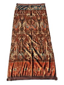
A Fine RARE Antique Woven ikat Pictorial TextilePremier Auction Galleries4.4(331)See Sold PriceMar 09, 2024
Group of Ten Railroad Photographs, Maps, and Prints - New Jersey, Long Island, and New YorkRail & Road Auctions4.6(165)See Sold PriceMar 07, 2024
Chatelain - Map of the Americas and Details and Insets of Government CounselsTrillium Antique Prints & Rare Books4.5(32)See Sold PriceFeb 24, 2024
Catherwood - General View of Uxmal, Taken from the Archway of Las Monjas, Looking SouthTrillium Antique Prints & Rare Books4.5(32)See Sold PriceFeb 24, 2024
Carey, pub. 1796 - A Chart of the West IndiesTrillium Antique Prints & Rare Books4.5(32)See Sold PriceFeb 24, 2024
Carey, pub. 1796 - Map of the State of MarylandTrillium Antique Prints & Rare Books4.5(32)See Sold PriceFeb 24, 2024
Carey, pub. 1796 - Map of GeorgiaTrillium Antique Prints & Rare Books4.5(32)See Sold PriceFeb 24, 2024
Carey, pub. 1796 - Map of The State of South CarolinaTrillium Antique Prints & Rare Books4.5(32)See Sold PriceFeb 24, 2024
Carey, pub. 1796 - Map of KentuckyTrillium Antique Prints & Rare Books4.5(32)See Sold PriceFeb 24, 2024
Carey, pub. 1796 - Map of the Tennassee State formerly part of North Carolina (Tennessee)Trillium Antique Prints & Rare Books4.5(32)See Sold PriceFeb 24, 2024
De Jode, Rare, pub. 1593 - Map of the Middle East, Eastern Asia (Primae Partis Asiae accurataTrillium Antique Prints & Rare Books4.5(32)See Sold PriceFeb 24, 2024
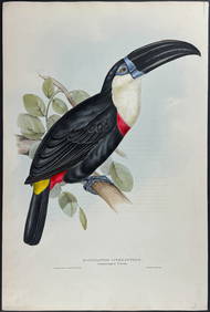
Gould - Natterer's Aracari or ToucanTrillium Antique Prints & Rare Books4.5(32)See Sold PriceFeb 24, 2024
1738 RUSSIA SIBERIA & GREAT TARTARY Description illustrated ANTIQUE in ENGLISHJasper524.5(9.9k)See Sold PriceFeb 27, 2024
ANTIQUE ILLUSTRATED HANDBOOK OF GEOGRAPHY AND TRAVEL IN ASIA, VOLUME 2, 1896NY Elizabeth 4.2(86)See Sold PriceMar 03, 2024
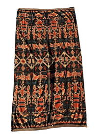
TURKMEN CENTRAL ASIA SILVER CARNELIAN TRIBAL BELTAntique Arena Inc.4.5(878)See Sold PriceJun 15, 2024
TURKMEN CENTRAL ASIA SILVER CARNELIAN TRIBAL HEADDRESSAntique Arena Inc.4.5(878)See Sold PriceJun 15, 2024