ATLAS of ANTIENT GEOGRAPHY by SAMUEL BUTLER 1843John McInnis Auctioneers,LLC4.6(502)See Sold PriceFeb 24, 2024
18TH C. ANTIQUE MAP: FRENCH & INDIAN WAR, FRAMEDThomaston Place Auction Galleries4.4(386)See Sold PriceFeb 24, 2024
Rand McNally Railroad Map Cabinet w/ 21 Railroad MapsRail & Road Auctions4.6(165)See Sold PriceMar 08, 2024
Keith Haring - Ink on New York Map, Best Buddies, Inscribed, Signed, and DatedSapphire Auction Gallery4(67)See Sold PriceMar 02, 2024
LATE 17TH C. FRENCH MAP OF THE NEW WORLD BY ALEXIS-HUBERT JAILLOT (1632-1712)Thomaston Place Auction Galleries4.4(386)See Sold PriceFeb 24, 2024
Central Railroad of New Jersey Map of Sandy Hook Route-ca. 1903JM Hobby Supply and Railroad Artifact Auctions4.4(126)See Sold PriceFeb 24, 2024
Lot of Six Mixed Atlas Box Cars-HO Scale-New in BoxJM Hobby Supply and Railroad Artifact Auctions4.4(126)See Sold PriceFeb 25, 2024
Rand McNally/Santa Fe Railroad Map of Iowa-1912JM Hobby Supply and Railroad Artifact Auctions4.4(126)See Sold PriceFeb 24, 2024
NICOLAES VISSCHER (NETHERLANDS, 1618-1709) MAP OF THE NEW WORLDThomaston Place Auction Galleries4.4(386)See Sold PriceFeb 24, 2024
17TH C. WORLD MAP BY NICOLAES VISSCHER (NETHERLANDS, 1618-1709)Thomaston Place Auction Galleries4.4(386)See Sold PriceFeb 24, 2024
Lot of Six Mixed Atlas Cabooses-HO Scale-New in BoxJM Hobby Supply and Railroad Artifact Auctions4.4(126)See Sold PriceFeb 25, 2024
SoldTUNISON'S MAP OF CALIFORNIA, NEVADA, OREGON(lot) Tunison's map of "California, Nevada and Oregon", the verso with maps of Utah and Montana, c. 1903, repair at center fold, size: open with full depiction of California: 23.25"h, 14.5"w Start PriSee Sold Price
TUNISON'S MAP OF CALIFORNIA, NEVADA, OREGON(lot) Tunison's map of "California, Nevada and Oregon", the verso with maps of Utah and Montana, c. 1903, repair at center fold, size: open with full depiction of California: 23.25"h, 14.5"w Start PriSee Sold Price
SoldTUNISON'S MAP OF CALIFORNIA, NEVADA, OREGON(lot) Tunison's map of "California, Nevada and Oregon", the verso with maps of Utah and Montana, c. 1903, repair at center fold, size: open with full depiction of California: 23.25"h, 14.5"w Start PriSee Sold Price
SoldGroup of Two Maps of the Southwest(1) Map of Texas. 1898. Rand, McNally & Company's Indexed Atlas of the World. Sheet: 21 1/2 x 27 3/4 inches. (2) Tunison's Montana, Utah. California, Nevada and Oregon. ca. 1902. Sheet: 14 9/16 x 22 1See Sold Price
Tunison's California, Nevada and OregonTitle: Tunison's California, Nevada and Oregon Publication Date: 1902 ca. Cartographer: TUNISON Publisher: TUNISON Size: 21 X 13 Map with counties separately colored. Also topo., towns and townships.See Sold Price
Tunison's California, Oregon, and NevadaReserve Reduced! Title: Tunison's California, Oregon, and Nevada Publication Date: 1885 Cartographer: TUNISON, HENRY CUTHBERT Publisher: H.C. TUNISON Size (inches): 19.8Height - 12.5Width On reverse,See Sold Price
Sold3 Maps: CALIFORNIA & NEVADA + OREGON.[United States/West]. Asher & Adams. 3 Maps, lithographs in colors, each with center fold, few small spots, very good condition, slightly toned. ++ CALIFORNIA & NEVADA. NORTH PORTION. 1872. 16 ½ x 23See Sold Price
California and Nevada (and) Oregon And Washington (And)Title/Content of Map: California and Nevada (and) Oregon And Washington (And) San Francisco Date: 1881 Cartographer: GRAY Publisher: GRAY Size: 24Height - 15Width Lg. map of CA & NV showing counties,See Sold Price
SoldWall map of California & NevadaHeading: (Wall Map - California & Nevada) Author: Title: Webers Township and County-Map of California, Nevada and Southern Oregon. Compiled and drawn from the latest data Place Published: San FrancisSee Sold Price
SoldMap of California, Oregon Utah Nevada +Map of California, Oregon, Idaho, Utah, Nevada, Arizona and Washington PLUS Mexico and Central America on verso Two maps on one sheet. (back to back). Hand colored.See Sold Price
Map of California, Oregon Utah Nevada +Map of California, Oregon, Idaho, Utah, Nevada, Arizona and Washington PLUS Mexico and Central America on verso Two maps on one sheet. (back to back). HandSee Sold Price
Map of California, Oregon Utah Nevada +Map of California, Oregon, Idaho, Utah, Nevada, Arizona and Washington PLUS Mexico and Central America on verso Two maps on one sheet. (back to back). HandSee Sold Price
Map of California, Oregon Utah Nevada +Map of California, Oregon, Idaho, Utah, Nevada, Arizona and Washington PLUS Mexico and Central America on verso Two maps on one sheet. (back to back). HandSee Sold Price
SoldCalifornia, Nevada, Oregon, Washington, Idaho, Utah MapCalifornia, Nevada, Oregon, Washington, Idaho, Utah, Arizona and Part of Montana. Size: 18 X 13 inches approx. Unframed. Printed 1878. Centerfold as issued.See Sold Price
California, Nevada, Oregon, Washington, Idaho, Utah MapCalifornia, Nevada, Oregon, Washington, Idaho, Utah, Arizona and Part of Montana. Size: 18 X 13 inches approx. Unframed. Printed 1878. Centerfold as issued.See Sold Price
(Pacific States) California, Nevada, Oregon,Reserve Reduced! Title: (Pacific States) California, Nevada, Oregon, Washington, Idaho, Utah, Arizona and Part of Montana. Publication Date: 1890 Cartographer: BARTHOLOMEW, JOHN & CO. Publisher: MACMISee Sold Price
SoldCadrian's 1921 State Highway Auto Guide (120883)Cadrian's 1921 State Highway Auto Guide for California, Nevada, Western Oregon and Washington. This handy guide covers 18,000 miles of roads, conditions, distances and altitudes in its 96 pages. BookSee Sold Price
SoldPost offices of California, 1894 mapHeading: Author: United States, Post Office Department Title: Post Route Map of the States of California and Nevada With Adjacent Parts of Oregon, Idaho, Utah, Arizona and The Republic of Mexico ShowSee Sold Price
Gray's New Map of California, 1886Map: Gray's New Map of California Maker: O.W. Gray and Son, Frank A. Gray Date: 1886 Size: Folio - 26.75 x 16.75 inches Reverse: Washington and Oregon and Nevada From Gray's The National Atlas, SpeciaSee Sold Price
California, New Mexico, Arizona, Nevada, Utah, OregonTitle: California, New Mexico, Arizona, Nevada, Utah, Oregon and Washington. A very important map showing the changing American west. 1850 by Thomas Date/Period: c1850 Size: 16 1/2 x 13 1/2 inches. MaSee Sold Price
California, New Mexico, Arizona, Nevada, Utah, OregonTitle: California, New Mexico, Arizona, Nevada, Utah, Oregon and Washington. A very important map showing the changing American west. 1850 by Thomas Date/Period: c1850. Materials: Hand colored steel eSee Sold Price
California, New Mexico, Arizona, Nevada, Utah, OregonTitle: California, New Mexico, Arizona, Nevada, Utah, Oregon and Washington. . A very important map showing the changing American west. 1850 by Thomas Date/Period: c1850. Materials: Hand colored steelSee Sold Price
California, New Mexico, Arizona, Nevada, Utah, OregonTitle: California, New Mexico, Arizona, Nevada, Utah, Oregon and Washington. A very important map showing the changing American west. 1850 by Thomas Date/Period: c1850 Materials: Hand colored steel enSee Sold Price
California, New Mexico, Arizona, Nevada, Utah, OregonTitle: California, New Mexico, Arizona, Nevada, Utah, Oregon and Washington. A very important map showing the changing American west. 1850 by Thomas Date/Period: c1850 Materials: Hand colored steel enSee Sold Price
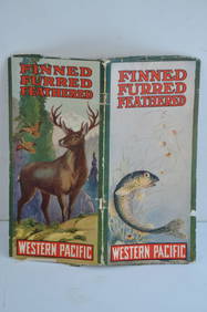
Western Pacific RR Finned Furred Feathered Brochure-1912JM Hobby Supply and Railroad Artifact Auctions4.4(126)See Sold PriceFeb 24, 2024
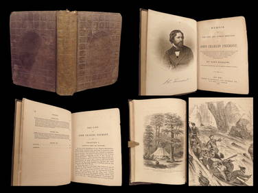
1856 CALIFORNIA 1st ed Memoir John C. Fremont Expeditions Oregon Trail IndiansSchilb Antiquarian Rare Books4.8(421)See Sold PriceMar 10, 2024
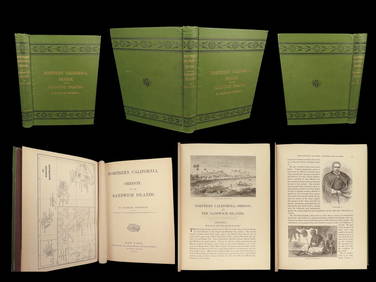
1874 HAWAII 1ed Northern California Oregon Pacific Island Travel Puget RedwoodsSchilb Antiquarian Rare Books4.8(421)See Sold PriceMar 10, 2024
Picturesque California, by John Muir, Volume 3, Imperial Japan EditionThe Scanlan Collection4.4(22)See Sold PriceFeb 24, 2024
Francis McNally - Antique Map of Washington, Oregon, Idaho, Nevada, Utah & ArizonaProverde Auctions4.3(3)See Sold PriceFeb 28, 2024