SoldMAP - DANCKERTS, I. [Justus] Recentissima Novi OrMAP - DANCKERTS, I. [Justus] Recentissima Novi Orbis Sive Americae Septentrionalis et Meridionalis Tabula ...Amsterdam: [1696]. Double-page engraved map (615 x 520 mm). Hand-colored outline anSee Sold Price
SoldDANCKERTS, Justus. Recentissima Novi Orbis Sive AmDANCKERTS, Justus. Recentissima Novi Orbis Sive Americae Septentrionalis et Meridionalis Tabula.Amsterdam: [c. 1696]. Double-page engraved map (615 x 520 mm). Hand-colored in outline and withSee Sold Price
SoldDANCKERTS. Recentissima Novi Orbis Sive Americae.DANCKERTS, Justus. Recentissima Novi Orbis Sive Americae Septentrionalis et Meridionalis Tabula.Amsterdam: [c. 1696]. Double-page engraved map (615 x 520 mm). Hand-colored in outline and withSee Sold Price
SoldRecentissima Novi Orbis sive Americae SeptentrionAuthor: Danckerts, Justus Copper-engraved map, hand-colored, with colored engraved pictorial cartouche. 49.2x57.5 cm. (19½x22¾"). North and South America, nicely engraved, brightly colored, with a sSee Sold Price
SoldDanckerts map of North America Calif. an islandTitle: Recentissima Novi Orbis sive Americae Septentrionalis et Meridionalis Tabula Author: Danckerts, Justus Description: Copper-engraved map, hand-colored, with colored engraved pictorial cartouche.See Sold Price
SoldRecentissima Novi Orbis Sive Americae. [ca 1690s].[North & South America]. Justus Danckerts. Recentissima Novi Orbis Sive Americae Septentrionalis et Meridionalis Tabula. [Ca. 1690’s.] 19 3/8” x 22 ½”. Foxed. Light, uniform toning. Sight condiSee Sold Price
SoldDANCKERTS, JUSTUS. Novi Belgii Novae Que Angliae NecDANCKERTS, JUSTUS. Novi Belgii Novae Que Angliae Nec Non Pennsylvaniae et Partis Virginiae Tabula. Double-page engraved map of New England with inset view of lower Manhattan. 19½x22¾ inchesSee Sold Price
Danckerts (Justus) Novi BelgiiDanckerts (Justus) Novi Belgii Nov'que Angli' nec non Pennsylvani' et Virgini' Tabula,second state of this early map of north east North America, with large title cartouche incorporating the fSee Sold Price
Sold* DANCKERTS, Justus (1635-1701). Novi Belgii Novaeque* DANCKERTS, Justus (1635-1701). Novi Belgii Novaeque Angliae nec non Partis Viginiae Tabula. [Amsterdam, ca 1655]. Engraved map, 466 x 553 mm image (sheet 482 x 593 mm). Figural cartouche incorporatiSee Sold Price
SoldDanckerts, Novi BelgiiDANCKERTS, Justus (1635-1701). Novi Belgii Novae Que Angliae Nec Non Pennsylvaniae et Partis Virginiae Tabula. Engraving with original hand color. Amsterdam: c. 1684. Dimensions. Comparables: StockholSee Sold Price
Sold[Map] de Wit, North and South America, c.1727Frederick de Wit and J. Danckerts (pirating each other) - "Recentissima Novi Orbis sive Americae Septentrionalis et Meridionalis Tabula" (Amsterdam: Ottens, c.1727) engraving with hand coloring, 20 XSee Sold Price
SoldJUSTUS DANCKERTS (Dutch, 1635-1701)JUSTUS DANCKERTS (Dutch, 1635-1701); ''NOVI BELGII NOVAEQUE ANGLIAE NEC NON PENNSYLVANIAE ET PARTIS VIRGINAE TABULA''; Map of northeast North America, ca. 1684 (framed); 19'' x 22'' (sight) Artist: DaSee Sold Price
SoldAN ANTIQUE MAP, "Recentissima Novi Orbis sive AmericæAN ANTIQUE MAP, "Recentissima Novi Orbis sive Americæ Septentrionalis et Meridionalis," CAREL ALLARD, AMSTERDAM, 17TH/18TH CENTURY, hand colored engraving on paper, Carel Allard (Dutch 1648See Sold Price
Danckerts (Justus) Novi BelgiiDanckerts (Justus) Novi Belgii Nov'que Angli' nec non Pennsylvani' et Virgini' Tabula,second state, with large title cartouche incorporating the panorama of New York, lower right, compass roseSee Sold Price
SoldDanckerts (Justus) Pennsylvania & VirginiaDanckerts (Justus) Novi Belgii Novæque Angliæ nec non Pennsylvaniæ et Virginiæ Tabula,second state, with large title cartouche incorporating the panorama of New York, lower right, compass roseSee Sold Price
SoldTurkish Empire Map, Justus Danckerts 1685Justin Danckerts: "Accuratissima et Maxima Totius Turcici Imperii Tabula..." Amsterdam, circa 1685. Copper plate engraving with hand coloring of the Turkish or Ottoman Empire, extending from Germany tSee Sold Price
DANCKERTS, Justus (1635-1701).DANCKERTS, Justus (1635-1701). Novi Belgii...tabula. [Amsterdam, ca 1690?]. 20th century reproduction. 21 1/4 x 25 1/4 in. Matted and Framed.See Sold Price
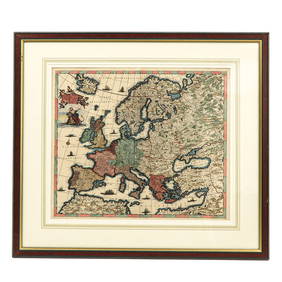
Antique Map Print - Europe - Map of Austria - Styria - Carniola - Tyrol - TrentJustus Danckerts. Map, the Austrian Circle in which are the archduchy of Austria, the duchy of Styria, Carinthia, Carniola, the County of Tyrol, and the episcopate of Trent, the latest description, CoSee Sold Price
Danckerts Novi Orbis MapNovi Orbis. Justinus Danckerts (1635 - 1701). Engraved Map with original hand color in part. Amsterdam: 1696. Burden 725. 21 x 24 inches sheet. Second State of Dankerts Maps of the Americas, much deriSee Sold Price
SoldDanckert's Maritime World MapNova Tabula Terrarum Orbis. Justus Danckerts (1635-1701). Engraved map with hand color in full. Amsterdam, [circa 1680]. 19 1/4 x 22 1/4 inches visible, 29 x 31 1/2 inches framed. This is Danckert’sSee Sold Price
Danckerts map of Africa c.1690Title: Novissima et Perfectissima Africæ Descriptio Author: Danckerts, Justus Description: Copper-engraved map, hand-colored; colored pictorial cartouche. 48x57 cm. (19x22½").The continent of AfricaSee Sold Price
SoldAllard Map of America with California as Island, 1697Map: Allard Map of America with California as Island - Recentissima Novi Orbis sive Americae Septentrionalis et Meridionalis Tabula Cartographer: C. Allard Date: ca. 1697 Size: 19 x 22.5 inches Nice lSee Sold Price
SoldDanckerts (Justus) Peloponnesus hodie MoreæDanckerts (Justus) Peloponnesus hodie Moreæ ...detailed map of Morea, and surrounding islands, with title cartouche lower left, surmounted by the Venetian lion, with captured Turks belowSee Sold Price
Sold1700 Allard Map of the Americas with California as anTitle/Content of Map: 1700 Allard Map of the Americas with California as an Island -- Recentissima Novi Orbis sive Americae Septentrionalis et Meridionalis Tabula Date: 1700, Amstrerdam Cartographer:See Sold Price
Central Railroad of New Jersey Map of Sandy Hook Route-ca. 1903JM Hobby Supply and Railroad Artifact Auctions4.4(126)See Sold PriceFeb 24, 2024
Rand McNally/Santa Fe Railroad Map of Iowa-1912JM Hobby Supply and Railroad Artifact Auctions4.4(126)See Sold PriceFeb 24, 2024
17TH C. WORLD MAP BY NICOLAES VISSCHER (NETHERLANDS, 1618-1709)Thomaston Place Auction Galleries4.4(386)See Sold PriceFeb 24, 2024
LATE 17TH C. FRENCH MAP OF THE NEW WORLD BY ALEXIS-HUBERT JAILLOT (1632-1712)Thomaston Place Auction Galleries4.4(386)See Sold PriceFeb 24, 2024
18TH C. ANTIQUE MAP: FRENCH & INDIAN WAR, FRAMEDThomaston Place Auction Galleries4.4(386)See Sold PriceFeb 24, 2024
NICOLAES VISSCHER (NETHERLANDS, 1618-1709) MAP OF THE NEW WORLDThomaston Place Auction Galleries4.4(386)See Sold PriceFeb 24, 2024
Nova Totius Full Color Geographical World MapThe Benefit Shop Foundation Inc.4.3(2.9k)See Sold PriceFeb 28, 2024
Keith Haring - Ink on New York Map, Best Buddies, Inscribed, Signed, and DatedSapphire Auction Gallery4(67)See Sold PriceMar 02, 2024
Rand McNally Railroad Map Cabinet w/ 21 Railroad MapsRail & Road Auctions4.6(165)See Sold PriceMar 08, 2024
Willem Blaeu, Etc. 17th C. Antiquarian Maps, 2Auctions at Showplace4.5(726)See Sold PriceMar 17, 2024
Putnam - First Map of the State of Ohio by Rufus PutnamTrillium Antique Prints & Rare Books4.5(30)See Sold PriceFeb 24, 2024


![MAP - DANCKERTS, I. [Justus] Recentissima Novi Or First Image](https://p1.liveauctioneers.com/839/16941/5652895_1_x.jpg?height=282&quality=95&version=1221072577&width=282)
![MAP - DANCKERTS, I. [Justus] Recentissima Novi Or (1 of 1)](https://p1.liveauctioneers.com/839/16941/5652895_1_x.jpg?height=282&quality=70&version=1221072577)
![MAP - DANCKERTS, I. [Justus] Recentissima Novi Or First Image](https://p1.liveauctioneers.com/839/16941/5652895_1_x.jpg?height=282&quality=1&version=1221072577&width=282)


![Recentissima Novi Orbis Sive Americae. [ca 1690s]. (1 of 4)](https://p1.liveauctioneers.com/179/41615/18011228_1_x.jpg?height=282&quality=70&version=1369948904)


![[Map] de Wit, North and South America, c.1727 (1 of 2)](https://p1.liveauctioneers.com/523/81971/42494505_1_x.jpg?height=282&quality=70&version=1447274451)