ATLAS of ANTIENT GEOGRAPHY by SAMUEL BUTLER 1843John McInnis Auctioneers,LLC4.6(502)See Sold PriceFeb 24, 2024
18TH C. ANTIQUE MAP: FRENCH & INDIAN WAR, FRAMEDThomaston Place Auction Galleries4.4(386)See Sold PriceFeb 24, 2024
Rand McNally Railroad Map Cabinet w/ 21 Railroad MapsRail & Road Auctions4.6(165)See Sold PriceMar 08, 2024
Keith Haring - Ink on New York Map, Best Buddies, Inscribed, Signed, and DatedSapphire Auction Gallery4(67)See Sold PriceMar 02, 2024
LATE 17TH C. FRENCH MAP OF THE NEW WORLD BY ALEXIS-HUBERT JAILLOT (1632-1712)Thomaston Place Auction Galleries4.4(386)See Sold PriceFeb 24, 2024
Central Railroad of New Jersey Map of Sandy Hook Route-ca. 1903JM Hobby Supply and Railroad Artifact Auctions4.4(126)See Sold PriceFeb 24, 2024
Lot of Six Mixed Atlas Box Cars-HO Scale-New in BoxJM Hobby Supply and Railroad Artifact Auctions4.4(126)See Sold PriceFeb 25, 2024
Rand McNally/Santa Fe Railroad Map of Iowa-1912JM Hobby Supply and Railroad Artifact Auctions4.4(126)See Sold PriceFeb 24, 2024
NICOLAES VISSCHER (NETHERLANDS, 1618-1709) MAP OF THE NEW WORLDThomaston Place Auction Galleries4.4(386)See Sold PriceFeb 24, 2024
17TH C. WORLD MAP BY NICOLAES VISSCHER (NETHERLANDS, 1618-1709)Thomaston Place Auction Galleries4.4(386)See Sold PriceFeb 24, 2024
Lot of Six Mixed Atlas Cabooses-HO Scale-New in BoxJM Hobby Supply and Railroad Artifact Auctions4.4(126)See Sold PriceFeb 25, 2024
Sold1896 BALTIMORE CITY ATLASActual surveys and original plans; Bromley; (34+/-) plats and outlines; re-bound; wear to sheets; 23" x 17", F-GSee Sold Price
SoldAtlas Baltimore City and Surrounds, 1878folio17 1/2 in., covers Baltimore City, Baltimore County, and Anne Arundel Country, single and double page mapsSee Sold Price
SoldC. M. HOPKINS ATLAS OF BALTIMORE and BALTIMORE COUNTYIncludes: (1) "City Atlas of Baltimore Maryland and Environs. From Official Records Private Plates and Actual Surveys, Based Upon Plans Deposited in the Department of Surveys." Surveyed and PublishedSee Sold Price
Sold(2) BALTIMORE BOOKS(1) "From Baltimore to Charleston" by J. R. Schaeffer, Artist and Printer; Gormania; WVA, 1906; (1) "Illustrated Baltimore - the Monumental City"; 1896; published by American Publishing and EngravingSee Sold Price
SoldTwo Atlas's 1869 Hartford City and County and 1896 CityTwo Atlas's 1869 Hartford City and County and 1896 City of Hartford.See Sold Price
SoldBaltimore Topographical Map Atlas Book, 1918large cloth bound volume with large linen backed fold out topographical maps of Baltimore City, 36 in. H., 22 in. W.See Sold Price
Sold1855 Colton Map of Baltimore -- City of BaltimoreTitle/Content of Map: 1855 Colton Map of Baltimore -- City of Baltimore Maryland Date: 1855, New York Cartographer: J Colton Size: 11.9 X 14.6 in. This is a very attractive city map. It is full of detSee Sold Price
1855 Colton Map of Baltimore -- City of BaltimoreReserve Reduced! Title/Content of Map: 1855 Colton Map of Baltimore -- City of Baltimore Maryland Date: 1855, New York Cartographer: J Colton Size: 11.9 X 14.6 in. This is a very attractive city map.See Sold Price
1855 Colton Map of Baltimore -- City of BaltimoreReserve Reduced! Title/Content of Map: 1855 Colton Map of Baltimore -- City of Baltimore Maryland Date: 1855, New York Cartographer: J Colton Size: 11.9 X 14.6 in. This is a very attractive city map.See Sold Price
Antique California Maps c1872-1896 (Lot of 3) (31975)1) 1896 City of San Francisco, 2000 feet to the inch, printed on newsprint, separated in two pieces at the center fold. Very detailed, some penciled notes in the top right. Map includes concentric cirSee Sold Price
Antique California Maps c1872-1896 (Lot of 3) (31975)1) 1896 City of San Francisco, 2000 feet to the inch, printed on newsprint, separated in two pieces at the center fold. Very detailed, some penciled notes in the top right. Map includes concentric cirSee Sold Price
Baltimore 1896Title/Content of Map: Baltimore 1896 Date Printed: 1896 Material/Medium: paper Size: approx. 11x 13.5 inches Rand McNally & Co. Universal Atlas of the World Reserve: $20.00 Shipping: Domestic: Flat-rSee Sold Price
Baltimore 1896Title/Content of Map: Baltimore 1896 Date Printed: 1896 Material/Medium: paper Size: approx. 11x 13.5 inches Additional Info: Rand McNally & Co. Universal Atlas of the World Reserve: $20.00 Shipping:See Sold Price
Baltimore 1896Title: Baltimore 1896 Date Printed: 1896 Material/Medium: paper Size: approx. 11x 13.5 inches Additional Info: Rand McNally & Co. Universal Atlas of the World Reserve: $20.00 Shipping: Domestic: Flat-See Sold Price
Baltimore 1896Title/Content of Map: Baltimore 1896 Date Printed: 1896 Material/Medium: paper Size: approx. 11x 13.5 inches Additional Info: Rand McNally & Co. Universal Atlas of the World Reserve: $25.00 Shipping:See Sold Price
Baltimore, 1896Title/Content of Map: Baltimore Date Printed: 1896 Material/Medium: paper Size: approx. 11x13.5 inches Rand McNally & Co. Universal Atlas of the World Reserve: $20.00 Shipping: Domestic: Flat-rate ofSee Sold Price
Baltimore 1896Title/Content of Map: Baltimore 1896 Date Printed: 1896 Material/Medium: paper Size: approx. 11x 13.5 inches Rand McNally & Co. Universal Atlas of the World Reserve: $30.00 Shipping: Domestic: Flat-rSee Sold Price
1855 Colton Map of Baltimore -- Colton's City ofTitle: 1855 Colton Map of Baltimore -- Colton's City of Baltimore, Maryland Cartographer: Johnson & Browning Year / Place: 1855, New York Map Dimension (in.): 12.7 X 15.7 in. This is a very attractiveSee Sold Price
1855 Colton Map of Baltimore -- Colton's City ofTitle/Content of Map: 1855 Colton Map of Baltimore -- Colton's City of Baltimore, Maryland Cartographer: Johnson & Browning Year/Place: 1855, New York Size: 12.7 X 15.7 in. This is a very attractive cSee Sold Price
1855 Colton Map of Baltimore -- Colton's City ofTitle: 1855 Colton Map of Baltimore -- Colton's City of Baltimore, Maryland Cartographer: Johnson & Browning Year / Place: 1855, New York Map Dimension (in.): 12.7 X 15.7 in. This is a very attractiveSee Sold Price
1855 Colton Map of Baltimore -- Colton's City ofTitle: 1855 Colton Map of Baltimore -- Colton's City of Baltimore, Maryland Cartographer: Johnson & Browning Year / Place: 1855, New York Map Dimension (in.): 12.7 X 15.7 in. This is a very attractiveSee Sold Price
SoldVARIOUS MISSOURI ADVTG FOBS INCL LIQUOR AND CIGARSIncludes Atlas Products, Hotel Baltimore of Kansas City, MO.; a 'James E. Aul - Good Things for the Table' of Webb City, MO., and a Clascer Bros. dealers in fine wines, liquors, and cigars, St. JosephSee Sold Price
Map of City of Baltimore, Maryland, 1876 by StedmanOriginal steel engraving from the Topographical Atlas of Maryland published by Stedman & Brown in 1876. Map features street view of parks, railroads & historic landmarks. Dimensions: 20” x 28 1/2”See Sold Price
Map of City of Baltimore, Maryland, 1876 by StedmanOriginal steel engraving from the Topographical Atlas of Maryland published by Stedman & Brown in 1876. Map features street view of parks, railroads & historic landmarks. Dimensions: 20” x 28 1/2”See Sold Price
Mansfield and Sandusky City RR 4th Annual Report-February 28, 1851JM Hobby Supply and Railroad Artifact Auctions4.4(126)See Sold PriceFeb 24, 2024
Eleven Pieces of North Eastern Railroad Flatware - Chesapeake & Ohio, Baltimore & Ohio, TheRail & Road Auctions4.6(165)See Sold PriceMar 08, 2024
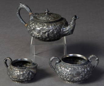
Three Piece Silverplated Tea Set, 19th c., by Justis and Armiger, Baltimore, with floral repousseCrescent City Auction Gallery4.3(229)See Sold PriceMar 01, 2024
Caroline Spelman Wogan Durieux (American/Louisiana, 1896-1989), Collection of Eight Drawings andCrescent City Auction Gallery4.3(229)See Sold PriceMar 01, 2024
[BASEBALL]. A group of 8 pinback buttons promoting Negro League baseball teams. Ca 1930s-1940s.Freeman's | Hindman4.4(1.6k)See Sold PriceFeb 27, 2024
Mitchell - Map of the City of Washington (Washington, DC)Trillium Antique Prints & Rare Books4.5(30)See Sold PriceFeb 24, 2024
FIVE ANTIQUE STERLING SILVER SOUVENIR TEASPOONS & FORKMannys Jewelry4.6(331)See Sold PriceMar 14, 2024
3 Vintage HO Scale Red CaboosesRapid Estate Liquidators and Auction Gallery4.5(1.1k)See Sold PriceFeb 24, 2024
FRENCH COLONIAL GUINEA. Guinee Française. Conakry city town ville plan 1929 mapJasper524.5(9.8k)See Sold PriceFeb 28, 2024
Africa. Congo Free Trade Area. British South Africa Company. STANFORD 1896 mapJasper524.5(9.8k)See Sold PriceFeb 28, 2024
Central Africa. Congo Free State Rhodesia German East Africa. STANFORD 1896 mapJasper524.5(9.8k)See Sold PriceFeb 28, 2024
FRENCH COLONIAL GUINEA. Guinee Française. Conakry city town ville plan 1931 mapJasper524.5(9.8k)See Sold PriceFeb 28, 2024
Group of Five Walking Sticks, 19th c., Narrow- H.- 34 3/4 in., W.- 3 1/2 in., D.- 1/4 in. (5 Pcs.)Crescent City Auction Gallery4.3(229)See Sold PriceMar 08, 2024
12K Gold Filled Elgin Railroad Pocket Watch, Size 0S, 1896, Knife- H.- 1 7/8 in. (2 Pcs.)Crescent City Auction Gallery4.3(229)See Sold PriceMar 09, 2024
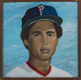
McCoy Stadium Juan Beniquez Monumental MuralBruneau & Co. Auctioneers4.5(491)See Sold PriceMar 18, 2024
TINA MODOTTI - DIEGO RIVERA & FRIDA KAHLO, MAY DAY PARADE, MEXICO CITY, 1929White Knight Auction, Inc4.7(248)See Sold PriceMar 03, 2024
TINA MODOTTI, WOMAN WITH FLAG, MEXICO CITY, 1928White Knight Auction, Inc4.7(248)See Sold PriceMar 03, 2024
GAVOY, EMILE. 1836-1896. Atlas d'anatomie topographique du cerveau et des localisations cér...Bonhams4.1(305)See Sold PriceJun 18, 2024


![[BASEBALL]. A group of 8 pinback buttons promoting Negro League baseball teams. Ca 1930s-1940s. (1 of 2)](https://p1.liveauctioneers.com/197/319238/171468154_1_x.jpg?height=282&quality=70&version=1707520367)