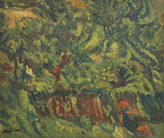
Chaim Soutine (Belarusian/French, 1893-1943) - La Petite Fille dans la VerdureFreeman's | Hindman4.5(158)See Sold PriceFeb 27, 2024
Elisabeth Frink (British, 1930-1993) - Harbinger Bird IFreeman's | Hindman4.5(158)See Sold PriceFeb 27, 2024
AMERICAN SEASCAPE PAINTING BY ROSS EMBROSE MOFFETTAntique Arena Inc.4.5(852)See Sold PriceMar 02, 2024
CHARLES HENRY GIFFORD (Massachusetts, 1839-1904), Luminist view of three sailboats in a quietEldred's4.7(409)See Sold PriceFeb 28, 2024
RARE MANHATTAN PROJECT GLASS LEADED FROM THE MANHATTAN PROJECT WORLD WAR II WW2 724 GRAMSCol. Christie Hatman Auctioneers4.5(312)See Sold PriceFeb 26, 2024
Estate Fresh Civil War Cavalry C. Roby 1863 With ScabbardRalph Fontaine Heritage Auctions Inc.4.7(235)See Sold PriceFeb 25, 2024
ABSTRACT ARAB LEBANESE OIL PAINTING BY ETEL ADNANAntique Arena Inc.4.5(852)See Sold PriceMar 02, 2024
SoldWWII 1942 DATED EVENTS WORLD WAR MAP by PETERSENWWII 1942 DATED EVENTS WORLD WAR MAP by PETERSEN ADVERTISING, Zitelli PITTSBURGH World War II Era DATED EVENTS WAR MAP--World map with war details highlighted. Copyright, Canada and USA 1942, C. C. PeSee Sold Price
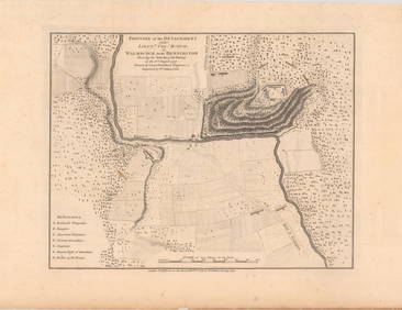
SoldRARE WORLD WAR ONE MAPS - PASSCHENDAELETwo RARE World War I military maps, depicting the advancing Battle for Passchendaele, 29 September 1917 and 29 October 1917. The maps depict the British (Canadian) front lines, German trenches, concreSee Sold Price
Sold11 Vintage Assorted World War II Maps of Europe11 Vintage Assorted World War II Maps of Europe from the 1940's, used condition, wear, worn.See Sold Price
Sold[Military - World War One - Maps] Group of 50 Highly[Military - World War One - Maps] Group of 50 Highly Detailed WWI Maps, Supplement to National Review Fifty maps issued as supplements to the National Review (London). The National Review was a conserSee Sold Price
Sold[World War One - Maps] Trench Maps, Vimy and[World War One - Maps] Trench Maps, Vimy and Wytschaete, Lot of 3 Lot of 3. Two for Vimy, edition 8A (corrected to Feb. 10, 1917) and 9A (Corrected to June 26, 1917). Latter with "A Coy" in ink on froSee Sold Price
2 World War II maps2 World War II maps. Pacific and European Theater. Title: 2 World War II map. Framed. Medium: Print. Size: 9.5 X 7.5See Sold Price
SoldDated Events World War 2 Map PetersenPetersen, C. C., Dated Events War Map, c.1945, color map on paper, mechanically folded as originally issued, 17.25 x 39 inches, this version sponsored by Knape and Vogt of Grand Rapids, Michigan.See Sold Price
SoldLINEOL mass, 7.5 cm, First World War, SA map reader,LINEOL mass, 7.5 cm, First World War, SA map reader, with white helmet, green hackle, condition 1 - 2 German Description LINEOL Masse, 7,5 cm, 1. Weltkrieg, SA Kartenleser, mit weißem Helm, gr&uSee Sold Price
Soldc. 1942 World Wide War Map, Sommers Drug, Yale Sales16 x 21", framed Provenance: San Antonio, TX Estate In-house nationwide shipping and statewide (Texas) delivery is available on this item. Please email shipping@vogtauction.com or call 210-822-6155 foSee Sold Price
SoldA World War II map for the 20th armored division inA World War II testimonial map of the 20th Armored Division trek across occupied France, Belgium, Germany and Austria, 19 inches high x 26 1/2 wide framed.See Sold Price
SoldWorld At War Map : United States As A World PowerThe World War Historical Map by Sanford – Gordy. Map shows the Nations At War. The League Of Nations and the United States As A World Power, After the Spanish American War. Colonial with PossessionsSee Sold Price
SoldU.S. Army Atlas European Theater in World War IITitle: U.S. Army Atlas of the European Theater in World War II. Maps Created and Compiled by the Staff of the U.S. Army Center of Military History, Washington, D.C. New York. Barnes & Noble. 2004 AuthSee Sold Price
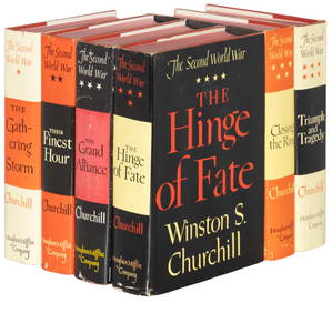
SoldThe Second World WarOne of the most comprehensive accounts of the Second World War. Contains maps, charts, copies of correspondence, lists of meeting and a vast array of relative information." Publishers black cloth withSee Sold Price
SoldD-DAY MAP, HEAVILY ANNOTATED WITH LANDINGS AT SWORDD-DAY MAP, HEAVILY ANNOTATED WITH LANDINGS AT SWORD BEACH Finely-annotated World War II map, 30 1/2" x 37 1/2", a 1:250,000-scale depiction of the coast of France between the Cotentin Peninsula and thSee Sold Price
SoldVIERVILLE-SUR-MER OMAHA BEACH D-DAY MAPVIERVILLE-SUR-MER OMAHA BEACH D-DAY MAP Extremely important World War II map, 20" x 25 3/4", a 1: 12,500-scale depiction of the Normandy village of Vierville-sur-Mer and environs, the beach of which wSee Sold Price
SoldGEN. CLARENCE HUEBNER'S 1ST INFANTRY DIVISION SICILYFROM THE ESTATE OF GEN. CLARENCE R. HUEBNER, COMMANDER OF THE 1ST INFANTRY DIVISION IN THE FIRST WAVE AT OMAHA BEACH Historically important World War II map used by Gen. Clarence R, Huebner in prepariSee Sold Price
SoldGROUPING OF HISTORY, PRINTS, AND WAR RELATED BOOKS:Various books and condition. Ca 19th/20th. Illustrated War news, War of nations, World book records, Worlds Fair, War map, Natural History, Canada map, General Middleton print, Currier & Ives print.See Sold Price
SoldStrategic Russian Map, World War I, 1917Strategic Russian Map, World War 1. 54x62 cm. Date: 1917 Shipping: Domestic: Flat-rate of $10.00 to anywhere within the contiguous U.S. International: Foreign shipping rates are determined by destinatSee Sold Price
SoldWORLD WAR II SS MAP COMPASSBlack bakelite German map compass, 2 x 2.75 in., lacking brass ring. With adjustable arrow and flip-up map scaler, and reflective mirror. ‘SS’ runes engraved on the top. Some wear to the pSee Sold Price
Sold(2) BOOKS: WORLD WAR I, ILLUSTRATED, MAPS, PHOTOS(lot of 2) " A Guide to the American Battle Fields in Europe", American Battle Monuments Commission, USGPO, 1927, illustrated with many photographs, fold out color highlighted maps, three large removaSee Sold Price
SoldGEN. CLARENCE R. HUEBNER'S WORLD WAR I BATTLE MAPSFROM THE ESTATE OF GEN. CLARENCE R. HUEBNER, COMMANDER OF THE 1ST INFANTRY DIVISION IN THE FIRST WAVE AT OMAHA BEACH Historically important World War I battle maps owned and used by future general ClaSee Sold Price
SoldCASED WORLD WAR II JAPANESE MAP MAKERS KIT.An interesting set of tools for making maps in a Japanese softwood (cedar?) box with Kanji on lid that identifies it as a map tools box. Black leatherette case with kanji on lid indicating that it holSee Sold Price
SoldGerman Millitary WWII Era Maps World WarGerman Millitary WWII Era Maps World War, "Militär Geographische Beschreibung von Frankreich, Teil 1, Nordost-Frankreich", German preparation maps for French invasion, 30 January, 1940, in original fSee Sold Price
SoldNew Revised Follow the War World Map...Title: New Revised Follow the War World Map... Publication Date: c1942 Cartographer: WINSLOW, ROB'T/R.J. WALRATH Publisher: IDEAL DISTRIBUTING CO. Size: 27.8Height - 43.5Width Brightly colored wartimeSee Sold Price
Jerusalem Map for British Soldiers in Palestine - WW2Levy Auction House4.3(11)See Sold PriceFeb 27, 2024
Collection of Allied Military Silk Printed Maps, WWII Era and LaterMaterial Culture4.6(765)See Sold PriceFeb 29, 2024
The Complete History of World War II 1948North American Artifact Auctions4.6(182)See Sold PriceApr 20, 2024
The First World War A Photographic History 1933. 1st EditionNorth American Artifact Auctions4.6(182)See Sold PriceApr 20, 2024
1938 American Armies and Battlefields by the American Battle Monuments CommissionNorth American Artifact Auctions4.6(182)See Sold PriceApr 20, 2024
War Diary of 354th Infantry - 89th Division 1919North American Artifact Auctions4.6(182)See Sold PriceApr 20, 2024
[WORLD WAR II – OKINAWA]. Okinawa Shima Western Beaches Top...Potter & Potter Auctions4.6(539)See Sold PriceMar 07, 2024
A quantity of World War II / Two military ephemera to include assorted 1940s newspapers pages toClaydon Auctioneers Ltd4.3(125)See Sold PriceFeb 26, 2024
First World War.- Petre (F.Loraine), Wilfrid Ewart & Major General Lowther. The Scots Guards in theForum Auctions4.3(52)See Sold PriceFeb 29, 2024
SECOND WORLD WAR AFRICA. European colonies & German mandates 1940 old mapJasper524.5(9.8k)See Sold PriceFeb 28, 2024
Pre-SECOND WORLD WAR AFRICA. European colonies & German mandates 1942 old mapJasper524.5(9.8k)See Sold PriceFeb 28, 2024
World War 2 Europe Battle of the Atlantic 1939-43 Axis Expansion limits 1959 mapJasper524.5(9.8k)See Sold PriceFeb 28, 2024
Operation Torch Nov 1942-May 1943. World War 2. Western Mediterranean 1966 mapJasper524.5(9.8k)See Sold PriceFeb 28, 2024
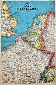
Vintage Map - Krigskarta - War Map - Second World War, published 1940Proverde Auctions4.3(3)See Sold PriceFeb 28, 2024


![[Tintype] Massive Bowie knife (1 of 1)](https://p1.liveauctioneers.com/7226/317626/170485482_1_x.jpg?height=282&quality=70&version=1706368022)
![[Ambrotype] Magnificent Portrait (1 of 1)](https://p1.liveauctioneers.com/7226/317626/170485477_1_x.jpg?height=282&quality=70&version=1706368022)


![[Tintype] Native American Man w/ Knife (1 of 2)](https://p1.liveauctioneers.com/7226/317626/170485453_1_x.jpg?height=282&quality=70&version=1706368022)
![[REES, Charles] Enlistedman w/ Bowie Knife (1 of 1)](https://p1.liveauctioneers.com/7226/317626/170485489_1_x.jpg?height=282&quality=70&version=1706368022)
![[Ambrotype] Wounded at Gettysburg (1 of 1)](https://p1.liveauctioneers.com/7226/317626/170485471_1_x.jpg?height=282&quality=70&version=1706368022)


![[Ambrotype] Young Soldier w/ Bowie Knife (1 of 1)](https://p1.liveauctioneers.com/7226/317626/170485459_1_x.jpg?height=282&quality=70&version=1706368022)

![[Daguerreotype] Soldier w/ Bowie Knife (1 of 2)](https://p1.liveauctioneers.com/7226/317626/170485458_1_x.jpg?height=282&quality=70&version=1706368022)
![[Tintype] Soldier w/ Flowers (1 of 1)](https://p1.liveauctioneers.com/7226/317626/170485495_1_x.jpg?height=282&quality=70&version=1706368022)
![[Tintype] Identified North Carolina Infantryman (1 of 2)](https://p1.liveauctioneers.com/7226/317626/170485474_1_x.jpg?height=282&quality=70&version=1706368022)


![[Military - World War One - Maps] Group of 50 Highly (1 of 7)](https://p1.liveauctioneers.com/46/113409/58240777_1_x.jpg?height=282&quality=70&version=1512492316)
![[World War One - Maps] Trench Maps, Vimy and (1 of 2)](https://p1.liveauctioneers.com/46/113409/58240775_1_x.jpg?height=282&quality=70&version=1512492316)


![[WORLD WAR II – OKINAWA]. Okinawa Shima Western Beaches Top... (1 of 1)](https://p1.liveauctioneers.com/928/318880/171361141_1_x.jpg?height=282&quality=70&version=1707501302)