ATLAS of ANTIENT GEOGRAPHY by SAMUEL BUTLER 1843John McInnis Auctioneers,LLC4.6(502)See Sold PriceFeb 24, 2024
18TH C. ANTIQUE MAP: FRENCH & INDIAN WAR, FRAMEDThomaston Place Auction Galleries4.4(386)See Sold PriceFeb 24, 2024
Rand McNally Railroad Map Cabinet w/ 21 Railroad MapsRail & Road Auctions4.6(165)See Sold PriceMar 08, 2024
Keith Haring - Ink on New York Map, Best Buddies, Inscribed, Signed, and DatedSapphire Auction Gallery4(67)See Sold PriceMar 02, 2024
LATE 17TH C. FRENCH MAP OF THE NEW WORLD BY ALEXIS-HUBERT JAILLOT (1632-1712)Thomaston Place Auction Galleries4.4(386)See Sold PriceFeb 24, 2024
Central Railroad of New Jersey Map of Sandy Hook Route-ca. 1903JM Hobby Supply and Railroad Artifact Auctions4.4(126)See Sold PriceFeb 24, 2024
Lot of Six Mixed Atlas Box Cars-HO Scale-New in BoxJM Hobby Supply and Railroad Artifact Auctions4.4(126)See Sold PriceFeb 25, 2024
Rand McNally/Santa Fe Railroad Map of Iowa-1912JM Hobby Supply and Railroad Artifact Auctions4.4(126)See Sold PriceFeb 24, 2024
NICOLAES VISSCHER (NETHERLANDS, 1618-1709) MAP OF THE NEW WORLDThomaston Place Auction Galleries4.4(386)See Sold PriceFeb 24, 2024
17TH C. WORLD MAP BY NICOLAES VISSCHER (NETHERLANDS, 1618-1709)Thomaston Place Auction Galleries4.4(386)See Sold PriceFeb 24, 2024
Lot of Six Mixed Atlas Cabooses-HO Scale-New in BoxJM Hobby Supply and Railroad Artifact Auctions4.4(126)See Sold PriceFeb 25, 2024
Four maps of Egypt, 16th - 19th centuryremoved from folio or quarto atlases, including: 1) "Descrittione dell'Egitto," (Venice: 1596); 2-3) Christoph Cellarius, "Aegyptus et Cyrenaica," and "Aegypti Delta et Nili Ostia" (Amsterdam: 1706);See Sold Price
N.R. Hewitt Engraved Map of Egypt 19th CenturyN.R. Hewitt Engraved Map of Egypt 19th Century, published by John Thomson & Co. Edinburgh, and Drawn by J. Wyld, matted and framed 12.5 in. x 9.5 in. Overall 18.5 in. x 15.5 in.See Sold Price
Five maps of Egypt, 16th - 18th centuryremoved from various quarto or octavo atlases; Property from the Hans Goedicke EstateSee Sold Price
Sold12 ANTIQUE ISLAMIC PAPER FRAGMENTS.12 ANTIQUE ISLAMIC PAPER FRAGMENTS. Egypt, c. 16th-early 19th century. Most with ornate designs, one with calligraphy both sides, includes one fabric with attached twine designs and embossed leather bSee Sold Price
SoldTwo 16th century maps: Egypt and Africatwo early engraved maps in octavo format: 1) After Ptolemy, "Tabula Aphricae II" showing Libya, the North African shore, and Mediterranean islands, from the Universal Geography, Cologne, Keschedt, 159See Sold Price
Seven old maps of Egypt, 18th and 19th centuryincluding maps of ancient Egypt and contemporary maps as of the late 18th and 19th century, including d'Anville and others; Property from the Hans Goedicke EstateSee Sold Price
COLLECTION OF NINE MAPS Various origins, 16th to 19thCOLLECTION OF NINE MAPS Various origins, 16th to 19th century. Engravings, coloured, on paper; partly verso with latin text. Sheet size min. ca. 19 x 25 cm / max. 56,5 x 65 cm. Part. spotty, brownish,See Sold Price
SoldGoss / Tooley. 2 map reference books[Reference]. 2 Titles. Near fine in vg djs. ++ R.V. Tooley. The Mapping Of America. Index compiled by Douglas Matthews. (Lon): Holland Press, (1985). 4to. Covers dozens of 16th-19th century maps thatSee Sold Price
SoldFour 19th Century Maps Pertaining to the Western Unitedas follows: Geological Map of a Part of the State of California Explored in 1855 by Lieut. R. S. Williamson U.S. Top Engr (Washington: War Department, 1856); color-coded (24.5 x 19.25 in.) (Some edgeSee Sold Price
SoldFour 19th century maps, Southeast"North America, Sheet XII, Georgia with parts of North & South Carolina, Tennessee, Alabama & Florida", by J. & C. Walker, from [Maps of the Society for the Diffusion of Useful Knowledge. Vol. 1,] pubSee Sold Price
SoldA Group of Four Hand-colored Engraved Maps, 19th/20thA Group of Four Hand-colored Engraved Maps, 19th/20th Century, Including three maps by Gerardus Mercator depicting Austria Archiducatus, Saltzburg and Flanders, and one map by Frederick de Wit depictiSee Sold Price
Sold19th/20th c. German Maps, 16 totalGrouping of sixteen 19th and 20th century German maps. Five (5) 19th century maps include: Four German (4) folding maps with the original folders including German map "Plan der Umgebung von SsewasstopSee Sold Price
Lot of Four 19th-cent. US Atlas Maps of South AmericaMap Title: Four 19th-century U.S. atlas maps of South America Cartographer: Finley; Tanner; Greenleaf; Mitchell Place/Date: Philadelphia / Brattleboro (VT) / 1829–1849 Size: Condition: full wash colSee Sold Price
SoldFour 19th century maps.  Paper on linen. Four 19th century maps.  Paper on linen.  Various.  Consisting of: Europe, Africa, Asia, America.  By M. de Humboldt AR Fremin, Paris.  Dimensions: H 57 x W 76 cm.  In fair / gSee Sold Price
SoldFour Washington D.C. Related Maps & Prints ca. 19th CenturyGroup of four Washington D.C. related maps & prints, ca. mid to late 19th century. Frame size of "Map of Washington. District of Columbia." are 10 1/2" H x 11 1/2" W x 3/8" D.See Sold Price
Sold1850 McDowall Diamond Maps ATLAS Geography England1850 McDowall Diamond Maps ATLAS Geography England Scotland Ireland World Color A collection of 19th-century McDowall maps. These four maps are extremely desirable, hand-colored views. Maps include: �See Sold Price
Sold[Prints/Maps]. 11 Items. Mid-16th to 19th Century[Prints/Maps]. 11 Items. Mid-16th to early 19th Century. Size varies, generally very good condition. 3 matted and framed. ++ Engraving Of The Inside Of A Family Dwelling Of The Inhabitant Of Van DamieSee Sold Price
Sold3 books: Early mapping of east Asia.[Map Reference]. 3 Titles. ++ Japan: A Cartographic Vision: European Printed Maps from the Early 16th to the 19th Century. Edited by Lutz Walter. German East-Asiatic Society (OAG). Munich/NY: Prestel,See Sold Price
SoldTwo volumes on cartography of JapanTitle: Two volumes on cartography of Japan Author: ** Description: Includes: * Walter, Lutz, editor. Japan: A Cartographic Vision. European Printed Maps from the Early 16th to the 19th Century. Red clSee Sold Price
Antique Map, Environs of LondonFramed antique map, "Environs of London". 19th century. Oval map with four corner cartouches depicting New London Bridge, Triumphal Arch, Hammersmith Suspension Bridge, and New Post Office. The imageSee Sold Price
FOUR BUDDHIST FIGURES, THAILAND AND CHINA, 16TH-19THDescription: FOUR BUDDHIST FIGURES, THAILAND AND CHINA, 16TH-19TH CENTURIES comprising three Thai figures of Buddha, each seated on raised thrones, with hands in bhumisparsa and dhyana mudra, two of cSee Sold Price
SoldFour 19th Century TN MapsFour (4) 19th Century Tennessee Maps, incl. Thomas G. Bradford, 1838. 1st item: "Tennessee" Map by Thomas G. Bradford, engraved by George W. Boynton, 1838. From "A Comprehensive Atlas, Geographical, HSee Sold Price
SoldGrp: 13 Maps of Italy and from Munster's CosmograGroup of 17th-19th century maps. This lot includes four pages from Sebastian Munster's "Cosmographia" including a map of Elba, a map of Italian mainland cities, a map of Sicily, and a map of Africa. TSee Sold Price
SoldCollection of (4) 19th C. Maps/Portions of ChartsCollection of four 19th Century framed maps and portions of charts including the Mississippi River, Falmouth England, Plymouth Sound and the Western Hemisphere. All frames approximately 19" x 15". ConSee Sold Price
Tokens - Bronze Token, Jetton and Other Coin Group [53]TimeLine Auctions Ltd.4.5(183)See Sold PriceMar 09, 2024
1849 Mitchell School ATLAS 24 MAPS America Holy Land France Africa Egypt AsiaSchilb Antiquarian Rare Books4.8(421)See Sold PriceMar 31, 2024
A MATCHED SET OF FOUR 19TH-CENTURY AND FOUR MODERN FRUITWOOD KITCHEN CHAIRSHutchinson Scott Auctioneers4.4(39)See Sold PriceFeb 28, 2024
A SET OF FOUR 19TH CENTURY MAHOGANY HEPPLEWHITE STYLE DINING CHAIRSHutchinson Scott Auctioneers4.4(39)See Sold PriceFeb 28, 2024
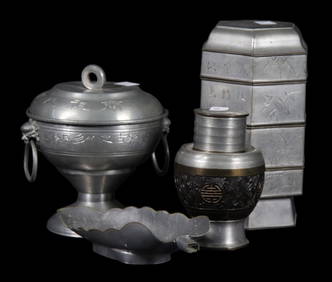
FOUR 19th CENTURY CHINESE PEWTER TEA SERVINGWARELewis & Maese Antiques & Auction4.4(520)See Sold PriceFeb 25, 2024
FOUR 19th CENTURY CHINESE PEWTER OBJECTSLewis & Maese Antiques & Auction4.4(520)See Sold PriceFeb 25, 2024
FOUR 19th CENTURY CHIPPENDALE SIDE CHAIRS.Lewis & Maese Antiques & Auction4.4(520)See Sold PriceFeb 25, 2024
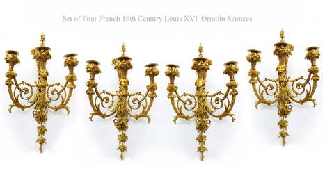
A Set Of Four 19th C. French Louis XVI Ormolu Sconces, Attrib. Henry DassonFive Star Auctions4.2(3)See Sold PriceFeb 29, 2024
1529 BIBLE ILLUSTRATED TEXTUS BIBLIA antique FOLIO in LATIN RARE 16th CENTURYJasper524.5(9.8k)See Sold PriceFeb 27, 2024
NUBIA. 'Nubie'. Nile Valley. Sudan Ethiopia Egypt. MALLET 1683 old antique mapJasper524.5(9.8k)See Sold PriceFeb 28, 2024
A SET OF FOUR 19TH CENTURY CONTINENTAL BRONZE WALLS SCONCES decorated with figures and berries. 32 cHannam's Auctioneers Ltd4.3(386)See Sold PriceFeb 27, 2024
FOUR 19TH CENTURY CHINESE CARVED WOOD TEMPLE PANELS Qing. Largest 40 cm x 15 cm. (4)Hannam's Auctioneers Ltd4.3(386)See Sold PriceFeb 29, 2024
A COLLECTION OF FOUR 19TH CENTURY SILVER FOLDING POCKET FRUIT KNIVESHutchinson Scott Auctioneers4.4(39)See Sold PriceJul 12, 2024


![[Prints/Maps]. 11 Items. Mid-16th to 19th Century (1 of 0)](https://p1.liveauctioneers.com/dist/images/placeholder.jpg?height=282&quality=70)


![Tokens - Bronze Token, Jetton and Other Coin Group [53] (1 of 1)](https://p1.liveauctioneers.com/1191/317894/170617562_1_x.jpg?height=282&quality=70&version=1706620797)