ATLAS of ANTIENT GEOGRAPHY by SAMUEL BUTLER 1843John McInnis Auctioneers,LLC4.6(502)See Sold PriceFeb 24, 2024
18TH C. ANTIQUE MAP: FRENCH & INDIAN WAR, FRAMEDThomaston Place Auction Galleries4.4(386)See Sold PriceFeb 24, 2024
Rand McNally Railroad Map Cabinet w/ 21 Railroad MapsRail & Road Auctions4.6(165)See Sold PriceMar 08, 2024
Keith Haring - Ink on New York Map, Best Buddies, Inscribed, Signed, and DatedSapphire Auction Gallery4(67)See Sold PriceMar 02, 2024
LATE 17TH C. FRENCH MAP OF THE NEW WORLD BY ALEXIS-HUBERT JAILLOT (1632-1712)Thomaston Place Auction Galleries4.4(386)See Sold PriceFeb 24, 2024
Central Railroad of New Jersey Map of Sandy Hook Route-ca. 1903JM Hobby Supply and Railroad Artifact Auctions4.4(126)See Sold PriceFeb 24, 2024
Lot of Six Mixed Atlas Box Cars-HO Scale-New in BoxJM Hobby Supply and Railroad Artifact Auctions4.4(126)See Sold PriceFeb 25, 2024
Rand McNally/Santa Fe Railroad Map of Iowa-1912JM Hobby Supply and Railroad Artifact Auctions4.4(126)See Sold PriceFeb 24, 2024
NICOLAES VISSCHER (NETHERLANDS, 1618-1709) MAP OF THE NEW WORLDThomaston Place Auction Galleries4.4(386)See Sold PriceFeb 24, 2024
17TH C. WORLD MAP BY NICOLAES VISSCHER (NETHERLANDS, 1618-1709)Thomaston Place Auction Galleries4.4(386)See Sold PriceFeb 24, 2024
Lot of Six Mixed Atlas Cabooses-HO Scale-New in BoxJM Hobby Supply and Railroad Artifact Auctions4.4(126)See Sold PriceFeb 25, 2024
SoldGroup of 14 Antique MapsGroup of 14 Antique Maps: 1) Japan, unknown date, published by Blackie + Sons; 2) Asia circa 1814 published by J+G Menzies; 3) Asia circa 1814 published by Nuttal, Fisher + Dixon; 4) Asia of unknown dSee Sold Price
SoldThree Antique MapsA group of three antique maps measuring approximately 14 1/4" x 20". Unframed, loose and not glued or mounted. We ship most items in this auction in house and gladly combine shipping if possible of muSee Sold Price
SoldGroup of 9 MapsLot of nine antique maps. 1746 Bellin map of Cape Verde island. H 10" W 14". 1574 Sebastion Munster map from 'Cosmographia Universalis'. H 12-5/8" W 7-1/8". 1598 Sebastion Munster map of Ireland, ScotSee Sold Price
SoldGroup of Antique MapsPetermann 1874, Midwest, covers area of Little Big Horn, 1876 Indian Territory, and two relating to Columbus' travels.See Sold Price
SoldEphemera: Folio of Maps, Antique Book Frontpieces, moreGroup lot of assorted ephemera. Dimensions: Folio - 18.75" H x 14.25" W; See Sold Price
SoldA Group of Antique Prints and Maps18th and 19th centuries, subjects include animals, French maps, architecture, classical and anthropological. Dimensions: From 9 1/2" x 8 1/2" to 14" x 10".See Sold Price
SoldGroup (14) antique postcards including (10) EdwardGroup (14) antique postcards including (10) Edward CurtisSee Sold Price
SoldBrockhaus (Pub) 1890's Mixed Lot of 14 Antique MapsIncl Poland, North America, Chicago, Atlantic Ocean Routes, France and Military Locations, Australia, Athens, British North America, Balkans, Bohemia, and Alexandria. Lithograph Maps Published 1892-98See Sold Price
SoldGroup of 14 Antique Fountain PensIncludes Waterman's #8, Ideal, Parker, Pentel, some with Gold Nibs.See Sold Price
SoldGroup of 14 Antique Toothpick HoldersCirca early 1900s, includes Texas star, Fostoria, tiny thumbprint and more 2 1/2 inches tallSee Sold Price
SoldGroup of 14 Antique Chinese Silver PendantsGroup of 14 Antique Chinese Silver PendantsGroup of 14 antique Chinese repoussé silver lock form pendants, various designs, including: calligraphy, figures, birds and florals (some small flaws); L: 2See Sold Price
SoldGROUP OF 14 ANTIQUE RUSSIAN 18THC SILVER TUMBLERSA GROUP OF THIRTEEN RUSSIAN SILVER TUMBLERS FROM THE 18TH CENTURY AND ONE 19THC, a group of fourteen russian silver beakers featuring wild animals and birds, real and mythical, set amid scrolling vegeSee Sold Price
SoldGROUP OF ANTIQUE MAPSIncluded are: An early Mercator map of Burgundy; in German. The Road from London to Pool by Thomas Gardner; Continuation of the Road form York to West-Chester by Thomas Gardner; circa 1866 map of NebrSee Sold Price
SoldA GROUP OF 14 ANTIQUE BOOKS, EARLY 20TH CENTURY.A GROUP OF 14 ANTIQUE BOOKS, EARLY 20TH CENTURY. Including “Character Sketches from Charles Dickens” by Kyd published by Raphael Tuck and Sons; “Little Black Sambo”; “Alice’s Adventures inSee Sold Price
SoldGroup of 14 : Antique Bottles - "Kickapoo Indian Oil"Includes Healy & Bigelow's "Kickapoo Indian Oil", "My Wife's Salad Dressing", "Sure Cure", "One Minute Cough Syrup" , and more. Tallest antique bottle in this lot measures 9 inchesSee Sold Price
SoldGroup of 14 Antique Hat PinsConsisting of long and short pins, in a porcelain sugar caster "holder." Longest: 15" L.See Sold Price
SoldGroup of 14 Antique BookletsFeaturing Rawley's Almanac, House Cleaning Made Easy, and MoreSee Sold Price
SoldGroup of 14 Antique EtchingsSome hand colored, 2.5x4 inches. Deaccessioned by the Valentine Museum to benefit collections care, preservation and future acquisitions.See Sold Price
Two (2) Antique 18th C. Copper Engraved Framed Maps - America & EuropeMagnusson Art Group4.5(46)See Sold PriceMar 14, 2024
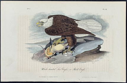
Audubon - White-headed Sea Eagle or Bald Eagle. 14Trillium Antique Prints & Rare Books4.5(30)See Sold PriceFeb 24, 2024
Set of 14 Antique Red Cauldon Porcelain PlatesOld Kinderhook Auction Company4.6(217)See Sold PriceMar 05, 2024
EARLY COLONIAL WEST AFRICA. Empires of Sokoto Gando Mas.Tribes.Fellatah 1882 mapJasper524.5(9.8k)See Sold PriceFeb 28, 2024
COLONIAL AFRICA Afrique. League of Nations Mandates. Ethnicity 1938 old mapJasper524.5(9.8k)See Sold PriceFeb 28, 2024
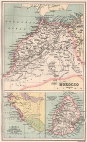
NORTH WEST AFRICA Maghreb Morocco Tunisia Algeria JOHNSTON 1897 old mapJasper524.5(9.8k)See Sold PriceFeb 28, 2024
MAGHREB. North Africa Morocco Algeria & Tunisia. JOHNSTON 1913 old antique mapJasper524.5(9.8k)See Sold PriceFeb 28, 2024
COLONIAL AFRICA Afrique. League of Nations Mandates. Ethnicity 1929 old mapJasper524.5(9.8k)See Sold PriceFeb 28, 2024
Africa. Mauritius, Bourbon (Reunion) & Natal by Edward Weller 1860 old mapJasper524.5(9.8k)See Sold PriceFeb 28, 2024
MOROCCO LIBERIA & MAURITIUS. Sierra Leone. BARTHOLOMEW 1886 old antique mapJasper524.5(9.8k)See Sold PriceFeb 28, 2024
MAGHREB. North Africa. Marocco Algeria and Tunis. BLACKIE 1886 old antique mapJasper524.5(9.8k)See Sold PriceFeb 28, 2024
AFRICA NW & SOUTH. Maghreb. Cape Colony electoral divisions. JOHNSTON 1906 mapJasper524.5(9.8k)See Sold PriceFeb 28, 2024
FRENCH COLONIAL GUINEA. Guinee Française. Conakry city town ville plan 1931 mapJasper524.5(9.8k)See Sold PriceFeb 28, 2024
Village & Hutes des Hottentots'. Southern Africa. Khoikhoi village. SCHLEY 1748Jasper524.5(9.8k)See Sold PriceFeb 28, 2024
Guinea-Bissau. Negroes of Cacheu & Bissau preparing cassava. Manioc. SCHLEY 1747Jasper524.5(9.8k)See Sold PriceFeb 28, 2024
NUBIA. 'Nubie'. Nile Valley. Sudan Ethiopia Egypt. MALLET 1683 old antique mapJasper524.5(9.8k)See Sold PriceFeb 28, 2024
AFRICA. French North Africa and Morocco 1907 old antique map plan chartJasper524.5(9.8k)See Sold PriceFeb 28, 2024
MAGHREB. North Africa. Marocco Algeria and Tunis. BLACKIE 1882 old antique mapJasper524.5(9.8k)See Sold PriceFeb 28, 2024
Egypte, Nubie et Abissinie. Egypt, Nubia & Abyssinia. Sudan. BONNE 1788 mapJasper524.5(9.8k)See Sold PriceFeb 28, 2024
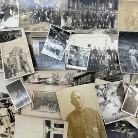
Photography - Set of 30 Photos from Japan - Group photographs - Military photographsProverde Auctions4.3(3)See Sold PriceFeb 28, 2024
Photography - Set of 30 Photos from Japan - Group photographs - LandscapesProverde Auctions4.3(3)See Sold PriceFeb 28, 2024
Photography - Set of 30 Photos from Japan - Group photographs and portraits of Japanese peopleProverde Auctions4.3(3)See Sold PriceFeb 28, 2024