ATLAS of ANTIENT GEOGRAPHY by SAMUEL BUTLER 1843John McInnis Auctioneers,LLC4.5(505)See Sold PriceFeb 24, 2024
18TH C. ANTIQUE MAP: FRENCH & INDIAN WAR, FRAMEDThomaston Place Auction Galleries4.4(393)See Sold PriceFeb 24, 2024
Rand McNally Railroad Map Cabinet w/ 21 Railroad MapsRail & Road Auctions4.6(165)See Sold PriceMar 08, 2024
Keith Haring - Ink on New York Map, Best Buddies, Inscribed, Signed, and DatedSapphire Auction Gallery4(67)See Sold PriceMar 02, 2024
LATE 17TH C. FRENCH MAP OF THE NEW WORLD BY ALEXIS-HUBERT JAILLOT (1632-1712)Thomaston Place Auction Galleries4.4(393)See Sold PriceFeb 24, 2024
Central Railroad of New Jersey Map of Sandy Hook Route-ca. 1903JM Hobby Supply and Railroad Artifact Auctions4.4(127)See Sold PriceFeb 24, 2024
Lot of Six Mixed Atlas Box Cars-HO Scale-New in BoxJM Hobby Supply and Railroad Artifact Auctions4.4(127)See Sold PriceFeb 25, 2024
Rand McNally/Santa Fe Railroad Map of Iowa-1912JM Hobby Supply and Railroad Artifact Auctions4.4(127)See Sold PriceFeb 24, 2024
NICOLAES VISSCHER (NETHERLANDS, 1618-1709) MAP OF THE NEW WORLDThomaston Place Auction Galleries4.4(393)See Sold PriceFeb 24, 2024
17TH C. WORLD MAP BY NICOLAES VISSCHER (NETHERLANDS, 1618-1709)Thomaston Place Auction Galleries4.4(393)See Sold PriceFeb 24, 2024
Lot of Six Mixed Atlas Cabooses-HO Scale-New in BoxJM Hobby Supply and Railroad Artifact Auctions4.4(127)See Sold PriceFeb 25, 2024
Geographical Statistical Map of Denmark & Sweden, 1822Map: Geographical and Statistical Map of Denmark and Sweden. Publication Date: 1822 Author: M. CAREY, GROS, C./J. YEAGER Publisher: M. CAREY Size: Quarto – 10.75 H x 14.50 W Inches Restriking of GroSee Sold Price
Geographical Statistical Map of Denmark & Sweden, 1822Map: Geographical and Statistical Map of Denmark and Sweden. Maker: M. Carey, Gros, C./j. Yeager Publication Date: 1822 Publisher: M. Carey Size: Quarto – 10.75 H x 14.50 W Inches Restriking of GrosSee Sold Price
SoldGEOGRAPHICAL & STATISTICAL MAPS OF DENMARK, SWEDEN & NODenmark, Sweden and Norway after the fall of Napolean 1820 by M. Carey & Son, hand-colored map surrounded by statistical data. Sight size 17 x 21 inches, overall 26.75 x 29.See Sold Price
Geographical and Statistical Map of Norway and SwedenTitle/Content of Map: Map of Denmark &C. | Geographical and Statistical Map of Norway and Sweden Date Printed: 1820 Cartographer: GROS, C. Size (inches): 11.6x11.3 "including the placed rendered celebSee Sold Price
SoldGeographical Statistical Historical Michigan Map, 1822Map: Geographical, Statistical and Historical Map of Michigan Territory Cartographer: Carey & Lea Publishing: Philadelphia, 1822 Size: 17 x 21.8 inches This is the first map only focused on Michigan TSee Sold Price
SoldGeographical Statistical Historical Louisiana Map, 1822Map: Geographical, Statistical and Historical Map of Louisiana Cartographer: H Carey & I Lea Publishing: Philadelphia, 1822 Size: 16.5 x 21 inches This is a great colored map of Louisiana, from CareySee Sold Price
SoldCarey: Geographical & Statistical Map of Europe, 1822Geographical and Statistical Map of Europe. M. Carey, Young & Delleker 1822. Restriking of map, Europe: drawn from the best authorities for the illustration of Lavoisne's genealogical, historical, chrSee Sold Price
Carey: Geographical and Statistical Map of Denmark andMap: Geographical and Statistical Map of Denmark and Sweden Maker: M. Carey, Gros, C./J. Yeager Publishing Date: 1822 Size: Quarto - 10.75 x 14.50 inches, Restriking of Gros's map of Denmark &c. And mSee Sold Price
Geographical Statistical & Historical Map of Peru, 1822Map: Geographical Statistical & Historical Map of Peru Maker: Carey & Lea, Finlayson, J. Publisher: Carey & Lea, Philadelphia 1822 Size: Double Folio – 13.60 H x 12.50 W Inches No. 50. Most conciseSee Sold Price
Geographical & Statistical Map of Spain & Portugal 1822Map: Geographical and Statistical Map of Spain and Portugal Maker: M. Carey, Gros, C./E. Paquenaud/J. Yeager Date: 1822 Size: Octavo, 10.6 inches high x 13 inches wide Restriking of a map by Gros, impSee Sold Price
SoldCarey & Lea - Virginia, 1822Henry Charles Carey (1793-1879) and Isaac Lea (1792-1886) makers, Geographical, Statistical, and Historical Map of Virginia, 1822, engraving on wove paper with hand color, 13-3/4 x 19-1/2 in. (plate),See Sold Price
Geographical, Statistical, and Historical Map ofTitle: Geographical, Statistical, and Historical Map of Kentucky Publication Date: 1822 Cartographer: LUCAS, FIELDING JR./YOUNG & DELLEKER Publisher: CAREY & LEA Dimensions: 11.25 X 18.3 Additional InSee Sold Price
SoldTN Map 1822, Lucas, Carey, & Lea"Geographical, Statistical, And Historical Map of Tennessee", drawn by Fielding Lucas, Jr., engraved by William Kneass, published by Henry C. Carey and Issac Lea, Philadelphia, 1822. From "A CompleteSee Sold Price
Sold1822 Geographical, Statistical, and Historical Map of1822 Geographical, Statistical, and Historical Map of Vermont, Henry Charles Carey and Isaac Lea, some tearing on creases, 17 by 21 inchesSee Sold Price
SoldAntique Map of Louisiana, Carey & Lea, 1822Antique Map of Louisiana , "Geographical, Statistical and Historical Map of Louisiana", Philadelphia, Carey & Lea, 1822, 16 3/4 in. x 21 1/4 in., framed . Provenance: By repute, Arader Galleries, NewSee Sold Price
Sold1822 VIRGINIA MAP1822 VIRGINIA MAP, hand-colored engraving, "Geographical, Statistical and Historical Map of Virginia" by Henry Charles Carey and Isaac Lea, Philadelphia, with descriptive text along lower edge. ModernSee Sold Price
1822 F Lucas Geographical, Statistical, & Historical1822 F Lucas Geographical, Statistical, & Historical Map of Vermont w/ letterpress text printed on the map, image 16.5” x 20.5”See Sold Price
T.G. Bradford: Map of Denmark Sweden Norway LaplandMap: Denmark, Sweden, Norway & Lapland Maker: T. G. Bradford Date: 1835 Size: 7.75 x 10 (9.5 x 12.875) inches From Bradford’s first atlas, the Comprehensive Atlas Geographical, Historical & CommerciSee Sold Price
Carey: Geographical Map of Spain & Portugal, 1822Map: Geographical and Statistical Map of Spain and Portugal. Publication Date: 1822 Authors: M. CAREY, GROS, C./E. PAQUENAUD/J. YEAGER Publisher: M. CAREY Size: Octavo – 10.60 H x 13.00 W Inches ResSee Sold Price
SoldCarey & Lea Map of Rhode Island, 1822Cartographer: Carey & Lea Year/Place of Publishing: 1822, Philadelphia 1822 Carey and Lea Map of Rhode Island -- Geographical, Statistical, and Historical Map of Rhode Island. This excellent early mapSee Sold Price
SoldCarey & Lea: Antique Map of North America, 1822Map: Geographical, Statistical, and Historical Map of North America Publication Date: 1822 Authors: CAREY & LEA, FINLAYSON, J./J. YEAGER Publisher: CAREY & LEA Size: Double Folio – 13.75 H x 13.30 WSee Sold Price
SoldGeographical, Statistical and Historical Map of CubaTitle: Geographical, Statistical and Historical Map of Cuba and the Bahama Islands Printing Date: 1822 Cartographer: TANNER, BENJAMIN Publisher: H.C. CAREY & I. LEA Size: 9.6Height - 13.75Width AdditiSee Sold Price
SoldFirst map of Missouri as a state 1822Heading: (Missouri) Author: Carey & Lea Title: Geographical, Statistical, and Historical Map of Missouri Place Published: Philadelphia Publisher: Date Published: 1822 Description: </See Sold Price
SoldHistorical Map Of The District of Columbia. 1822[Washington, D.C.] Geographical, Statistical, And Historical Map Of The District Of Columbia. Carey & Lea, Philadelphia, 1822. Hand colored engraved map. From A Complete Historical, Chronological, andSee Sold Price
Nova Totius Full Color Geographical World MapThe Benefit Shop Foundation Inc.4.3(2.9k)See Sold PriceFeb 28, 2024
Vintage County Map Of NY State Plate EngravingThe Benefit Shop Foundation Inc.4.3(2.9k)See Sold PriceFeb 28, 2024
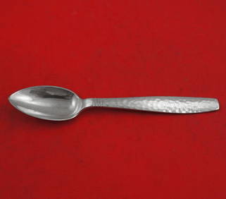
Swedish Modern by Allan Adler Sterling Silver Grapefruit Spoon Original 6"Bidhaus4.3(762)See Sold PriceFeb 25, 2024
Vintage Framed Pine Island & Lacoste Island MapThe Benefit Shop Foundation Inc.4.3(2.9k)See Sold PriceMar 06, 2024
1822 MAP of LEEWARD ISLANDS GEOGRAPHICAL STATISTICAL HISTORICAL antique 17.5x22"Jasper524.5(9.9k)See Sold PriceFeb 27, 2024
1822 MAP of SOUTH AMERICA GEOGRAPHICAL STATISTICAL HISTORICAL antique 17.5x 22"Jasper524.5(9.9k)See Sold PriceFeb 27, 2024
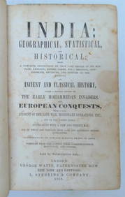
1858 INDIA HISTORY ILLUSTRATED antique Geographical, Statistical, and HistoricalJasper524.5(9.9k)See Sold PriceFeb 27, 2024
1822 MAP of NORTH & SOUTH AMERICA GEOGRAPHICAL STATISTICAL HISTORICAL antiqueJasper524.5(9.9k)See Sold PriceFeb 27, 2024
1822 MAP of CHILI GEOGRAPHICAL STATISTICAL HISTORICAL antique 17.5x 22" CHILEJasper524.5(9.9k)See Sold PriceFeb 27, 2024
1558 SCANDINAVIA SWEDEN ILLUSTRATED HISTORY Gothorum Sveonumque historia antiqueJasper524.5(9.9k)See Sold PriceFeb 27, 2024
Swedish Modern by Allan Adler Sterling Silver Preserve Spoon 7"Mynt Auctions4.6(697)See Sold PriceMar 01, 2024
Sigvard Bernadotte, Bernadotte flatware serviceToomey & Co. Auctioneers4.7(392)See Sold PriceFeb 29, 2024
Geographical, Statistical, and Historical Map of the Leeward Islands.Jasper524.5(9.9k)See Sold PriceFeb 27, 2024
Geographical Statistical and Historical Map of the Windward IslandsJasper524.5(9.9k)See Sold PriceFeb 27, 2024
Geographical, Statistical, and Historical Map of the West Indies.Jasper524.5(9.9k)See Sold PriceFeb 27, 2024
Cooke, George 1801 Antique Map. Sweden, Denmark, Norway, IcelandAlbion Auctions4.6(341)See Sold PriceMar 01, 2024
Paterson & Mogg 1822 Pair of British Road Maps. Deal, Hythe, Shoreham, ChichesterAlbion Auctions4.6(341)See Sold PriceMar 01, 2024
Carl J. Sundevall (1801 - 1875) Set of 4 Bird Prints - Dove - Woodpecker - DuckProverde Auctions4.3(3)See Sold PriceFeb 28, 2024
Joachim Ferdinand Richardt - Set of 8 Prints - Topographical views of Castels in Sweden - SkabersjöProverde Auctions4.3(3)See Sold PriceFeb 28, 2024
Joachim Ferdinand Richardt - Set of 8 Prints - Topographical views of Castels in Sweden - RosendahlProverde Auctions4.3(3)See Sold PriceFeb 28, 2024
Set of 4 Maps - Netherlands - Seven United Provinces - Germany - Sweden, Denmark, Norway, FinlandProverde Auctions4.3(3)See Sold PriceFeb 28, 2024