Framed Colored Map Of Bohemia.Dated 1886. Framed under glass. Excellent Framed: 17'' x 14-1/4''.See Sold Price
Framed Colored Map Of Bohemia.This lot consists of a colored framed map of Bohemia. It is dated 1886. On the upper left corner there is a seal with text surrounding it: "Handkarte Des Konigreiches Bohmen." Keys are found on the loSee Sold Price
SoldMap of Bohemia, 19th centuryFramed hand-colored etching, Map of Bohemia, 19th century, overall: 27.75''h x 31.25''wSee Sold Price
SoldFramed Colored Map Of Judea IsraelColored map depicting Judea Israel. To corner reads Typs chorogra, phicvs, celebrivm locorvm in regno Ivdae Et Israhel. Framed in gold metal leafed wooden frame. with linen edges, Approximately 19.5 xSee Sold Price
SoldFramed Colored Map Of JerusalemColored map of Jerusalem. Right corner reads Palestine & Sive, totivs terrae pro missionis nova descripto avc, tore tilemanno, Stella sigenens. Depicts colored map with green land and brown mountains.See Sold Price
Sold18th Century Hand Colored Map, Bohemia,"Royaume de Bohemes", approx 10" x 15".....The Kingdom of Bohemia (in Czech: České království; in German: Königreich Böhmen; in Latin: Regnum Bohemiae) is a kingdom located in the region ofSee Sold Price
SoldFramed colored map of North America,Framed colored 17th/18th century map of North America, detailed map showing eastern seaboard extending to the Caribbean, the western U.S being largely uncharted with Mendocino Bay being the last northSee Sold Price
Circa 1900, framed, colored map of Florida, 8 1/2Circa 1900, framed, colored map of Florida, 8 1/2"x9 1/2"See Sold Price
SoldFramed colored map of Ducatus GelriaeFramed colored map of Ducatus Gelriae Tetrachia Arnhemiensis Sive Velavia, Amsterdam & nbsp; P. Mortier, printed t'Amsterdam by F. de Wit in the Kalverstraet on the Dam in the WittePascaert 47x57 cm,See Sold Price
SoldFramed colored map of ZutphaniaFramed colored map of Zutphania by F. de Wit, ca.1700, 49x57 cm, including frame 66.5x73 cmSee Sold Price
SoldLOT OF (2) FRAMED COLORED MAPS, 19TH CENTURYOne is Mexico Overall framed- 21" x 26", 22 3/4" x 27"See Sold Price
Five Framed Maps, Bohemia & MoraviaFive framed maps comprising four maps of Bohemia by Johann Baptiste Homann (German, 1664-1724) and one of Moravia by Johann Amos Comenius (German, 1592-1670). Sight size: 15" high, 20" wide to 19 1/4"See Sold Price
Sold3 Antique Connecticut District Framed Colored Maps3 Antique Connecticut District Hand Colored Framed Maps. 3 antique framed hand colored maps of the Connecticut business districts of Wallingford, Farmington, and Cheshire. 26 inches x 17 inchesSee Sold Price
SoldVINTAGE FRANCIS DRAKE 1586 INDIAN VOYAGE MAPFramed colored map dated 1586 from Sir Francis Drake's FAMOUS W. INDIAN VOYAGE MADE BY 23 SHIPS. This is a 20th century reprint laid down on cardboard. 16 x 21 inches, framed 22 x 26.See Sold Price
SoldEARLY MAP OF GERMANY, SELISIAFramed colored map of German region, "Princip Silesiae Iavoriensis", in Latin, upper right corner having title cartouche surrounded by allegorical figures with 1736 date printed in Roman numerals, legSee Sold Price
1868 BRITISH AMERICA MAPFramed colored map of British America dated 1868 by Longman and Co. of London. 13 x 15 inches, framed 24 x 28.See Sold Price
SoldMap of Nantucket.Matted and framed colored map of Nantucket island. Topography is in color with points of interest noted. Outer margins have bearings noted. Bottom of print has a statue and nautical miles legend. DimeSee Sold Price
SoldFRAMED HAND COLORED MAP 1817, US & ST. LAURENCE RVFramed hand colored map, "The United States of America (with) The course of the River St. Laurence, from Lake Ontario to Manicouagan Point" engraved by J.G. Menzies, from "A new general atlas, consistSee Sold Price
SoldNEW ZEALAND 1851 FRAMED HAND COLORED MAPEngraved map of New Zealand 1851. J Rapkin, the illustrations by H. Warren & engraved by J. B. Allen . Hand colored with decorative border, inset vignette views.. Image 10 x 26 inches. Overall 14 1/2See Sold Price
SoldFRAMED PRINT, COLORED MAP OF CHINA, JAMES WYLDFramed print on paper, "Map of China, Compiled from Original Surveys and Sketches", James Wyld (English, 1812-1887), published by J. Wyld, London, sight: 24.5"h, 31.5"w, overall: 25.75"h, 33"w, 11lbsSee Sold Price
SoldFramed Hand Colored Map of The World 19th CenturyFramed Hand Colored Map of The World 19th Century. Original Map of World Hemispheres with supposed population and religious division. Certificate of Authenticity on back.Condition: Very Good, slight wSee Sold Price
SoldTwo Early Framed Hand Colored Mapscomprising Johann Baptist Homann (German, 1664-1724), "Nova Anglia" and a smaller unsigned map, "Dania Regnum." Not examined out of frames. Stains, toning. Largest: 27 1/2" high, 30 1/2" wide. ProvenaSee Sold Price
SoldAntique Framed & Hand Colored Map of LiverpoolAntique Framed & Hand Colored Map of Liverpool England. Measures 20 x 24 inches.See Sold Price
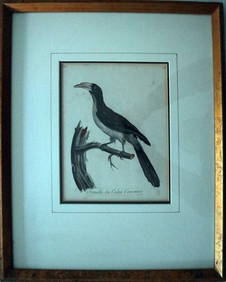
Le Valliant Crowned Hornbill Calao Couronne Rare Engraving ca1802 Framed OrnithologyLuis Porretta Fine Arts4.3(10)See Sold PriceMar 02, 2024
Max Papart (1911-1994) Lithograph Hand Signed 11" x 11" Blue & Green FormsLuis Porretta Fine Arts4.3(10)See Sold PriceMar 02, 2024
WILLIAM HEATH Rare Political Cartoon Siamese Youths c1829 LithographLuis Porretta Fine Arts4.3(10)See Sold PriceMar 02, 2024
TOTI LEWIS Canadian Listed Artist Mural Painters Artists Proof Etching 1983Luis Porretta Fine Arts4.3(10)See Sold PriceMar 02, 2024
PIETER SCHENK / VALK / JANSSEN Hand Colored Map of Rhodes Greece ca1702 vgcLuis Porretta Fine Arts4.3(10)See Sold PriceMar 02, 2024
RIGOBERT BONNE c1787 Original Colored Map Germany & Region 15" x 12"Luis Porretta Fine Arts4.3(10)See Sold PriceMar 02, 2024
THOMAS MOULE 1837 Colored Map of Warwickshire Framed vgcLuis Porretta Fine Arts4.3(10)See Sold PriceMar 02, 2024
Vintage Full Color World Map LithographThe Benefit Shop Foundation Inc.4.3(3k)See Sold PriceFeb 28, 2024
Nova Totius Full Color Geographical World MapThe Benefit Shop Foundation Inc.4.3(3k)See Sold PriceFeb 28, 2024
Kilburg Geochron Lighted Scrolling Framed MapNadeau's Auction Gallery4.7(410)See Sold PriceFeb 24, 2024
Hand Colored Map of the city of Amsterdam 1720Global Auctions Company4.3(36)See Sold PriceMar 03, 2024
17th Century Hand Colored Engraved Map of GermanyGlobal Auctions Company4.3(36)See Sold PriceMar 03, 2024
18th Century Hess Germany Hand colored Engraved MapGlobal Auctions Company4.3(36)See Sold PriceMar 03, 2024
[ARCTIC]. BOWEN, Emanuel. A New & Accurate Map of the North...Potter & Potter Auctions4.6(550)See Sold PriceMar 07, 2024
Framed Hand Colored Antique Map of the Department of Nord, FranceDonny Malone Auctions4.5(1.8k)See Sold PriceMar 04, 2024
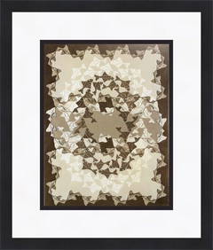
M.C. Escher - Fish II Custom Gallery Framed Colored PrintMynt Auctions4.6(711)See Sold PriceFeb 27, 2024
Framed Colored Print signed ARCADIO CANCIO Cuban artist.Basel Auction House4.5(48)See Sold PriceFeb 24, 2024
Galliae Regionis Nova Descriptio Hand Colored Map of France on Laid Paper, Ca. 16th Century, H 10" WDuMouchelles4.6(833)See Sold PriceMar 15, 2024


![[ARCTIC]. BOWEN, Emanuel. A New & Accurate Map of the North... (1 of 1)](https://p1.liveauctioneers.com/928/318880/171360917_1_x.jpg?height=282&quality=70&version=1707501302)