ATLAS of ANTIENT GEOGRAPHY by SAMUEL BUTLER 1843John McInnis Auctioneers,LLC4.6(502)See Sold PriceFeb 24, 2024
18TH C. ANTIQUE MAP: FRENCH & INDIAN WAR, FRAMEDThomaston Place Auction Galleries4.4(386)See Sold PriceFeb 24, 2024
Rand McNally Railroad Map Cabinet w/ 21 Railroad MapsRail & Road Auctions4.6(165)See Sold PriceMar 08, 2024
Keith Haring - Ink on New York Map, Best Buddies, Inscribed, Signed, and DatedSapphire Auction Gallery4(67)See Sold PriceMar 02, 2024
LATE 17TH C. FRENCH MAP OF THE NEW WORLD BY ALEXIS-HUBERT JAILLOT (1632-1712)Thomaston Place Auction Galleries4.4(386)See Sold PriceFeb 24, 2024
Central Railroad of New Jersey Map of Sandy Hook Route-ca. 1903JM Hobby Supply and Railroad Artifact Auctions4.4(126)See Sold PriceFeb 24, 2024
Lot of Six Mixed Atlas Box Cars-HO Scale-New in BoxJM Hobby Supply and Railroad Artifact Auctions4.4(126)See Sold PriceFeb 25, 2024
Rand McNally/Santa Fe Railroad Map of Iowa-1912JM Hobby Supply and Railroad Artifact Auctions4.4(126)See Sold PriceFeb 24, 2024
NICOLAES VISSCHER (NETHERLANDS, 1618-1709) MAP OF THE NEW WORLDThomaston Place Auction Galleries4.4(386)See Sold PriceFeb 24, 2024
17TH C. WORLD MAP BY NICOLAES VISSCHER (NETHERLANDS, 1618-1709)Thomaston Place Auction Galleries4.4(386)See Sold PriceFeb 24, 2024
Lot of Six Mixed Atlas Cabooses-HO Scale-New in BoxJM Hobby Supply and Railroad Artifact Auctions4.4(126)See Sold PriceFeb 25, 2024
SoldRare J.H. Colton Color Map of Iowa and Minnesota19th Century J.H. Colton’s map of Iowa and Minnesota - color map set on backing board and shrink wrapped. 11 1/2â€W X 14â€HSee Sold Price
Rare J.H. Colton Color Map of Iowa and Minnesota19th Century J.H. Colton’s map of Iowa and Minnesota - color map set on backing board and shrink wrapped. 11 1/2”W X 14”HSee Sold Price
SoldRare J.H. Colton Color Map of Iowa and Minnesota19th Century J.H. Colton’s map of Iowa and Minnesota - color map set on backing board and shrink wrapped. 11 1/2”W X 14”HSee Sold Price
Rare J.H. Colton Color Map of Iowa and Minnesota19th Century J.H. Colton’s map of Iowa and Minnesota - color map set on backing board and shrink wrapped. 11 1/2â€W X 14â€HSee Sold Price
Rare J.H. Colton Color Map of Iowa and Minnesota19th Century J.H. Colton’s map of Iowa and Minnesota - color map set on backing board and shrink wrapped. 11 1/2â€W X 14â€HSee Sold Price
Rare J.H. Colton Color Map of Iowa and Minnesota19th Century J.H. Colton’s map of Iowa and Minnesota - color map set on backing board and shrink wrapped. 11 1/2”W X 14”HSee Sold Price
Rare J.H. Colton Color Map of Iowa and Minnesota19th Century J.H. Colton’s map of Iowa and Minnesota - color map set on backing board and shrink wrapped. 11 1/2”W X 14”HSee Sold Price
Rare J.H. Colton Color Map of Iowa and Minnesota19th Century J.H. Colton’s map of Iowa and Minnesota - color map set on backing board and shrink wrapped. 11 1/2â€W X 14â€HSee Sold Price
Rare J.H. Colton Color Map of Iowa and Minnesota19th Century J.H. Colton’s map of Iowa and Minnesota - color map set on backing board and shrink wrapped. 11 1/2â€W X 14â€HSee Sold Price
Rare J.H. Colton Color Map of Iowa and Minnesota19th Century J.H. Colton’s map of Iowa and Minnesota - color map set on backing board and shrink wrapped. 11 1/2â€W X 14â€HSee Sold Price
Rare J.H. Colton Color Map of Iowa and Minnesota19th Century J.H. Colton’s map of Iowa and Minnesota - color map set on backing board and shrink wrapped. 11 1/2”W X 14”HSee Sold Price
Rare J.H. Colton Color Map of Iowa and Minnesota19th Century J.H. Colton’s map of Iowa and Minnesota - color map set on backing board and shrink wrapped. 11 1/2â€W X 14â€HSee Sold Price
SoldRARE Coltons County and Township Map J H COLTON 1864Details: UNITED STATES - COLTON, J.H. (1800-1893). Colton's County and Township Map of the States of Illinois, Wisconsin, Minnesota, Iowa and Missouri, with parts of Indiana, Michigan, Kansas and NebSee Sold Price
SoldEarly pocket map of MinnesotaHeading: Author: Colton, J.H. Title: Minnesota Place Published: New York Publisher:J.H. Colton & Co Date Published: 1855 Description: Folding color map, 12 x 15 inches. FolSee Sold Price
Early pocket map of MinnesotaHeading: Author: Colton, J.H. Title: Minnesota Place Published: New York Publisher:J.H. Colton & Co Date Published: 1855 Description: Folding color map, 12 x 15 inches. FolSee Sold Price
[MAP] Colton’s Sectional Map of the State of Iowa. 1867267. [MAP]. COLTON, J.H, (copyright) & G.W. & C.B. Colton (publisher). Colton’s Sectional Map of the State of Iowa.... New York, 1867. Lithograph map on banknote paper, original full colSee Sold Price
SoldRare J.H. Colton Map, Southern Regions, Antarctica, South PoleRare mid 19th Century map of Southern Regions, Antarctica, South Pole, The Southern Polar Regions by J. H. Colton, from an 1855 first edition, Colton's Atlas of The World. A rare look at Antarctic expSee Sold Price
Colton's Map of the World on Mercator's Projection 1861Heading: Author: Colton, J.H. Title: Colton's Map of the World on Mercator's Projection 1861 Place Published: New York Publisher:J.H. Colton Date Published: 1861 Description: <See Sold Price
Sold1 piece. Color Lithographic Map. (Colton, J.H.) F1 piece. Color Lithographic Map. (Colton, J.H.) Florida." (New York), [ca. 1856]. 13 1/4 x 16 1/2 inches; 336 x 420 mm. With inset of the Florida Keys. Clean. Framed."See Sold Price
Sold1855 MAP OF IOWA BY J.H. COLTONPre-Civil War map of the state, professionally matted, 13 x 15.5 inch sight size.See Sold Price
SoldFramed 1855 Map Of California.This color map has an inset at the upper right of the City of San Francisco. It was published by J.H. Colton & Co. of New York. It is in exquisite condition and beautifully matted and framed. 24-3/4"TSee Sold Price
Sold[MAP]. Colton’s Map of the United States.... 1856.265. [MAP]. COLTON, J.H. Colton’s Map of the United States of America, the British Provinces, Mexico, and the West Indies, Showing the Country from the Atlantic to the Pacific Ocean...New York 1See Sold Price
Crams Railroad Map of New York-1881JM Hobby Supply and Railroad Artifact Auctions4.4(126)See Sold PriceFeb 24, 2024
Crams Township and Railroad Map of New York-1890JM Hobby Supply and Railroad Artifact Auctions4.4(126)See Sold PriceFeb 24, 2024
Kenyons Pocket Map and Shippers Guide of Wisconsin-1914JM Hobby Supply and Railroad Artifact Auctions4.4(126)See Sold PriceFeb 24, 2024
Rand McNally Township County and Railroad Map of Illinois-1879JM Hobby Supply and Railroad Artifact Auctions4.4(126)See Sold PriceFeb 24, 2024
Rand McNally/Santa Fe Railroad Map of Iowa-1912JM Hobby Supply and Railroad Artifact Auctions4.4(126)See Sold PriceFeb 24, 2024
Rock Island RR Iowa and Minnesota Lakes Country Brochure-1926JM Hobby Supply and Railroad Artifact Auctions4.4(126)See Sold PriceFeb 24, 2024
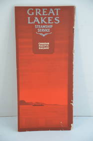
Canadian Pacific RY Great Lakes Steamship 1919 Brochure and TimetableJM Hobby Supply and Railroad Artifact Auctions4.4(126)See Sold PriceFeb 24, 2024
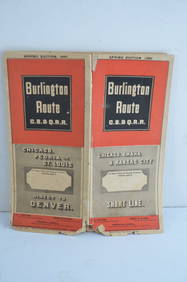
Chicago Burlington and Quincy RR Spring 1885 Public TimetableJM Hobby Supply and Railroad Artifact Auctions4.4(126)See Sold PriceFeb 24, 2024
Chicago Milwaukee and St Paul RY March 1, 1889 Public TimetableJM Hobby Supply and Railroad Artifact Auctions4.4(126)See Sold PriceFeb 24, 2024
1849 Mitchell School ATLAS 24 MAPS America Holy Land France Africa Egypt AsiaSchilb Antiquarian Rare Books4.8(421)See Sold PriceMar 31, 2024
GEORGE ANDREW CORLEY (DATES UNKNOWN) U.S. TEAM SKI TRYOUTS / MT. HOOD OREGON. 1939.Swann Auction Galleries4.4(65)See Sold PriceFeb 29, 2024
ANTIQUE ILLUSTRATED HANDBOOK OF GEOGRAPHY AND TRAVEL IN ASIA, VOLUME 2, 1896NY Elizabeth 4.3(84)See Sold PriceMar 03, 2024
Rare 19thc Colton Map, Argentine Republic, Chile, Uruguay, PataguayConnoisseur Auctions4(333)See Sold PriceMar 16, 2024


![[MAP] Colton’s Sectional Map of the State of Iowa. 1867 (1 of 7)](https://p1.liveauctioneers.com/514/38480/16487138_1_x.jpg?height=282&quality=70&version=1363614971)


![[MAP]. Colton’s Map of the United States.... 1856. (1 of 1)](https://p1.liveauctioneers.com/514/38480/16487134_1_x.jpg?height=282&quality=70&version=1363614971)