Cary: Map of Russia Under the Czars, 1799Map: 1799 Cary Map of Russia Under the Czars -- A New Map of the Russian Empire, Divided into its Governments; from the Latest Authorities Cartographer: J. Cary Year / Place: 1799 London Map DimensionSee Sold Price
Cary Map of Russia Under the Czars, 1799Map: 1799 Cary Map of Russia Under the Czars -- A New Map of the Russian Empire, Divided into its Governments; from the Latest Authorities Cartographer: J. Cary Year / Place: 1799 London Map DimensionSee Sold Price
Cary Map of Russia Under the Czars, 17991799 Cary Map of Russia Under the Czars -- A New Map of the Russian Empire, Divided into its Governments; from the Latest Authorities. A magnificent map of the Russian Empire in its zenith. Great detaSee Sold Price
SoldCary: Antique Map of Russia Under the Czars, 1799Title/Content of Map: 1799 Cary Map of Russia Under the Czars -- A New Map of the Russian Empire, Divided into its Governments; from the Latest Authorities Date Printed: 1799 London Cartographer: J. CSee Sold Price
Cary: Antique Map of Russia Under the Czars, 1799Map: 1799 Cary Map of Russia Under the Czars -- A New Map of the Russian Empire, Divided into its Governments; from the Latest Authorities Cartographer: J. Cary Year / Place: 1799 London Dimensions: 1See Sold Price
SoldNew Map of the Russian Empire 1799[Russia]. J. Cary. A New Map Of The Russian Empire, Divided into its Governments, From the Latest Authorities. Two double-page sheets, Russia extending from Poland to the Bering Strait. Lon: 1799. EacSee Sold Price
SoldA New Map Of The Russian Empire, 1799.[Russia]. J. Cary. A New Map Of the Russian Empire. Divided into its Governments. Double-page engraving. Lon: John Cary, 1799. 18 x 39 3/4 in. Contemporary hand-coloring, with mountain ridges and swamSee Sold Price
SoldJOHN CARY 1799 MAP OF IRELANDHand colored engraving. Dimensions: (Paper) H 20" x W 26" Condition: Toning and wrinkles. With center fold and small worm holes.See Sold Price
1799 Cary Map of Central and West Germany-- A New Map of the Circles of the Upper and Lower RhineTitle: 1799 Cary Map of Central and West Germany-- A New Map of the Circles of the Upper and Lower Rhine from the Latest Authorities Cartographer: J Cary Year / Place: 1799, London Map Dimension (in.)See Sold Price
Antique Map Print - John Cary - United Provinces - Holland, Zealand, UtrechtAn extremely attractive example of John Cary's 1799 map of the Netherlands. Consists of the provinces of Holland, Zealand, Utrecht, Gelders, Over Yssel, Friesland, and Groningen, as well as Drent, DutSee Sold Price
SoldCary: New Map of Piedmont, 1799Title/Content of Map: New Map of Piedmont, Date Printed: 1799 Cartographer: CARY, JOHN Size (inches): x8.6 "the Duchies of Savoy and Milan; and the Republic of Genoa; with their subdivisions." PleaseSee Sold Price
J.CARY, MAP OF RUSSIAN EMPIRE 1799, 17" X 40"J. CARY, MAP OF RUSSIAN EMPIRE 1799, 17" X 40":17 3/4" x 40". Russian Empire divided into its governments. Two sheets hinged at center Framed. J. Cary engraver, London.See Sold Price
John Cary: Map of the Russian Empire, 1799Map: A New Map of the Russian Empire, Divided into its Governments; from the Latest Authorities Maker: John Cary Date: 1799 Origin: London Size: 18 x 40 inches A magnificent map of the Russian EmpireSee Sold Price
Cary: Map of Kingdom of Prussia, 1799Map: A New Map of the Kingdom of Prussia with its Divisions into Provinces and Governments from the Latest Authorities By: John Cary Date: 1799 (Dated) London Dimensions: 18 x 20 inches (45.7 cm x 50.See Sold Price
Sold1799 Map ITALY JOHN CARY "A New Map of Piedmont" 18th CA beautifully engraved and colored 18th Century map of Italy. This piece is entitled: "A New Map of Piedmon the Duchies of Savoy and Milan; and the Republic of Genoa; with their Subdivisions." EngraveSee Sold Price
SoldJohn Cary New Map of France Engraving 1799John Cary (ca. 1754–1835), "A New Map of France, Divided into Departments, as decreed by the National Assembly, MDCCXC," 1799. Hand colored engraved map of France. Dimensions: Sight; height: inSee Sold Price
1799 Map ITALY JOHN CARY "A New Map of Piedmont" 18th CThis is a beautifully engraved and colored 18th Century map of Italy. This piece is entitled: "A New Map of Piedmon the Duchies of Savoy and Milan; and the Republic of Genoa; with their Subdivisions."See Sold Price
SoldGuthrie, William 1799 Antique Map of RussiaCopper Engraved Map Published 1799, London for "A New Geographical, Historical and Commercial Grammar..." by William Guthrie. The maps are by D. Ogilby & Son and others. Folds as issued. Paper Size: 1See Sold Price
Sold1799 ITALIAN PIEDMONT MAP BY CARY1799 Italian map A NEW MAP OF PIEDMONT by John Cary, published London. VG condition with some toning to paper. 19.25 x 21.25 inches plus 1" frame.See Sold Price
SoldJohn Cary: Westphalia GermanyMap: A New Map of the Circle of Westphalia (Germany) Maker: John Cary From Cary's New Universal Atlas Origin: London Date: 1808 (Map dated 1799) Medium: Engraving hand-colored at publication Sheet SizSee Sold Price
Sold15 maps by John Cary. Handcolored outline.[Cary, John] 15 Maps. Lon: John Cary, cartouches 1799-1806. [Probably from the 1808 edition of “A New Universal Atlas.”] About 18” x 20” at outer edge of border, with variation. Orig hand-coloSee Sold Price
1719 Chatelain Map of Russia -- Carte Generale desTitle/Content of Map: 1719 Chatelain Map of Russia -- Carte Generale des Etats du Czar Empereur de Moscovie… Cartographer: H Chatelain Year/Place: 1719, Amsterdam Size: 15.3 X 38.3 in. This is a graSee Sold Price
1719 Chatelain Map of Russia -- Carte Generale desTitle: 1719 Chatelain Map of Russia -- Carte Generale des Etats du Czar Empereur de Moscovie… Cartographer: H Chatelain Year / Place: 1719, Amsterdam Map Dimension (in.): 15.3 X 38.3 in. This is a gSee Sold Price
AFTER PIOTR KARLOVICH KLODT VON JURGENSBURG (RUSSIA, 1805-1867)Thomaston Place Auction Galleries4.4(386)See Sold PriceFeb 24, 2024
Three Portrait Miniatures Of Napoleon First QuarterWorld of Antiques, Inc.3.9(74)See Sold PriceFeb 29, 2024
Johann Homann Hand-Colored Map Engraving, c. 1730Auctions at Showplace4.5(726)See Sold PriceMar 17, 2024
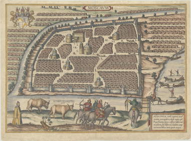
Duval - Pair: Map of Georgia & Map of Moscow, RussiaTrillium Antique Prints & Rare Books4.5(30)See Sold PriceFeb 24, 2024
Map: A 19thC engraved map titled Gloucestershire from the Best Authorities, after John Cary. Approx.Claydon Auctioneers Ltd4.3(125)See Sold PriceFeb 26, 2024
Map: A 19thC engraved and hand coloured map of Buckingham titled A New Map of BuckinghamshireClaydon Auctioneers Ltd4.3(125)See Sold PriceFeb 26, 2024
Map: A 19thC engraved map of West Riding, titled A Map of the North Part of the West Riding ofClaydon Auctioneers Ltd4.3(125)See Sold PriceFeb 26, 2024
1816 MAP SOUTHERN PART OF RUSSIA or MUSCOVY in EUROPE copper engraving ANTIQUEJasper524.5(9.8k)See Sold PriceFeb 27, 2024
1816 MAP NORTHERN PART OF RUSSIA or MUSCOVY in EUROPE copper engraving ANTIQUEJasper524.5(9.8k)See Sold PriceFeb 27, 2024
1758 MAP PARTIE DE LA MER GLACIALE contenants La Nouvelle Zemble RUSSIA antiqueJasper524.5(9.8k)See Sold PriceFeb 27, 2024
1749 MAP CARTE DE LA TARTARIE ORIENTALE RUSSIA & CHINA antique EASTERN TARTARYJasper524.5(9.8k)See Sold PriceFeb 27, 2024
1738 RUSSIA SIBERIA & GREAT TARTARY Description illustrated ANTIQUE in ENGLISHJasper524.5(9.8k)See Sold PriceFeb 27, 2024
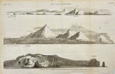
Antique Print with Coastal Views of Kamchatka in Russia by Cook, 1803Proverde Auctions4.3(3)See Sold PriceFeb 28, 2024