ATLAS of ANTIENT GEOGRAPHY by SAMUEL BUTLER 1843John McInnis Auctioneers,LLC4.6(504)See Sold PriceFeb 24, 2024
18TH C. ANTIQUE MAP: FRENCH & INDIAN WAR, FRAMEDThomaston Place Auction Galleries4.4(389)See Sold PriceFeb 24, 2024
Rand McNally Railroad Map Cabinet w/ 21 Railroad MapsRail & Road Auctions4.6(165)See Sold PriceMar 08, 2024
Keith Haring - Ink on New York Map, Best Buddies, Inscribed, Signed, and DatedSapphire Auction Gallery4.1(67)See Sold PriceMar 02, 2024
LATE 17TH C. FRENCH MAP OF THE NEW WORLD BY ALEXIS-HUBERT JAILLOT (1632-1712)Thomaston Place Auction Galleries4.4(389)See Sold PriceFeb 24, 2024
Central Railroad of New Jersey Map of Sandy Hook Route-ca. 1903JM Hobby Supply and Railroad Artifact Auctions4.4(126)See Sold PriceFeb 24, 2024
Lot of Six Mixed Atlas Box Cars-HO Scale-New in BoxJM Hobby Supply and Railroad Artifact Auctions4.4(126)See Sold PriceFeb 25, 2024
Rand McNally/Santa Fe Railroad Map of Iowa-1912JM Hobby Supply and Railroad Artifact Auctions4.4(126)See Sold PriceFeb 24, 2024
NICOLAES VISSCHER (NETHERLANDS, 1618-1709) MAP OF THE NEW WORLDThomaston Place Auction Galleries4.4(389)See Sold PriceFeb 24, 2024
17TH C. WORLD MAP BY NICOLAES VISSCHER (NETHERLANDS, 1618-1709)Thomaston Place Auction Galleries4.4(389)See Sold PriceFeb 24, 2024
Lot of Six Mixed Atlas Cabooses-HO Scale-New in BoxJM Hobby Supply and Railroad Artifact Auctions4.4(126)See Sold PriceFeb 25, 2024
SoldGreek Islands Cyclades Map, Mallet, 1683TITLE OF THE MAP: 'I(sles) de Micone de Nixia' The map depicts the Greek Cycladic islands of Micone (Miconos), Nixia (Naxos), Stenosa (Donousa), Stapodia (Ktapodia/Htapodia), Nicaria (Ikaria), Gyaro (See Sold Price
AEGEAN. Greece & Greek Islands Sporades Cyclades Saronic Ionian. MALLET 1683 mapTITLE OF THE MAP: 'Les Isles de l'Archipel qui sont de l'Europe' (De L'Europe) The maps runs from Morea northwards to Negropont. Stalimene. Lembro. etc. DATE PRINTED: 1683 IMAGE SIZE: Approx Overall pSee Sold Price
CYCLADES Sira (Syros/Siros) Paros Antiparos Greek islands Aegean MALLET 1683 mapTITLE OF THE MAP: 'I(sles) de Sira Sirna Paros' (De L'Europe) The map depicts the Greek Cycladic islands of Sira (Syros/Siros), Sirna, Paros & Antiraro (Antiparos) DATE PRINTED: 1683 IMAGE SIZE: ApproSee Sold Price
Mallet: Map of Cyclades, Greece, 1683TITLE OF THE MAP: 'I(sles) de Nio Namphio Sta Erini' The map depicts the Greek Cycladic islands of Nio (Ios), Namphio (Anafi), St Erini/Santorini (Thira), Policandro (Folegandros), Raclia (Irakleia),See Sold Price
Map of Greece & Greek IslandsAEGEAN. Greece & Greek Islands Sporades Cyclades Saronic Ionian. MALLET 1683 map Size: Approx Overall page size 13 x 21cm approximately (5 x 8 inches); image size 10.5 x 14.5cm approximately (4 x 5.5See Sold Price
CYCLADES. Mykonos Naxos Donousa Ktapodia Ikaria. Greek Islands. MALLET 1683 mapTITLE OF THE MAP: 'I(sles) de Micone de Nixia' (De L'Europe) The map depicts the Greek Cycladic islands of Micone (Miconos), Nixia (Naxos), Stenosa (Donousa), Stapodia (Ktapodia/Htapodia), Nicaria (IkSee Sold Price
CYCLADES. Amorgos, Zinara (Kinaros) & Levitha. Aegean. Greece. MALLET 1683 mapTITLE OF THE MAP: 'Is d'Amorgo et de Zinara' (De L'Asie) The map depicts the Greek Cycladic islands of Amorgo (Amorgos), Zinara (Kinaros) & Levita (Levitha) DATE PRINTED: 1683 IMAGE SIZE: Approx OveraSee Sold Price
Mallet: Map of Greek Cycladic Islands, 1683Title of the Map: 'Is d'Amorgo et de Zinara' CYCLADES. Amorgos, Zinara (Kinaros) & Levitha. Aegean. Greece. The map depicts the Greek Cycladic islands of Amorgo (Amorgos), Zinara (Kinaros) & Levita (LSee Sold Price
DODECANESE. Nicaria (Ikaria) et Palmosa/Patmos. Greek islands. MALLET 1683 mapTITLE OF THE MAP: 'Is de Nicaria et Patmo' (De L'Asie) The map depicts the Greek Dodecanese islands of Nicaria (Ikaria) and Palmosa (Patmo/Patmos) DATE PRINTED: 1683 IMAGE SIZE: Approx Overall page siSee Sold Price
Sporades, Kyra Panagia, Greece Map, Mallet 1683TITLE OF THE MAP: 'Is(les) de Pelagnisi Dromi &c' The map, which is orientated to towards the north east, depicts the Greek islands of Pelagnisi (Kyra Panagia), Dromo/Dromi (Alonissos), Schiat (SkiathSee Sold Price
NORTH AEGEAN Tasso (Thasos). Macedonia Thrace coast. Montesanto. MALLET 1683 mapTITLE OF THE MAP: 'I(sles) de Tasso et Montesanto' (De L'Europe) The map depicts the Greek islands of Tasso (Thasos) and Montesanto.The map shows the coast of Macedonia & Thrace, with Romania in the dSee Sold Price
AEGEAN ISLANDS. Sio (Chios) Pasara (Psara) & Mitylene (Lesbos). MALLET 1683 mapTITLE OF THE MAP: 'Is. de Sio et de Pasara' (De L'Asie) The map depicts the Greek islands of Sio (Chios), Pasara (Psara) & Strongiolo (presumably Ouriousses). Mitylene (Lesbos/Lesvos) is shown at theSee Sold Price
DODECANESE Leros Calamo Kalymnos Kalimnos Lango Kos Pserimos. MALLET 1683 mapTITLE OF THE MAP: 'Isle de Lero Calamo et de Lango' (De L'Asie) The map depicts the Greek Dodecanese islands of Lero (Leros), Calamo (Kalymnos), Lango (Kos), Caprone (Pserimos) & Aialglia (Telendos).See Sold Price
ASTYPALAIA. 'Isle de Stampalia'. Dodecanese islands. Greece. MALLET 1683 mapTITLE OF THE MAP: 'Isle de Stampalia' (De L'Asie) The map depicts the Greek Dodecanese island of Stampalia (Astypalaia) DATE PRINTED: 1683 IMAGE SIZE: Approx Overall page size 13 x 21cm approximatelySee Sold Price
DODECANESE. Scarpanto (Karpathos) Cassio (Kasos). Greece Aegean. MALLET 1683 mapTITLE OF THE MAP: 'Isle de Scarpanto' (De L'Asie) The map depicts the Greek Dodecanese islands of Scarpanto (Karpathos) & Cassio (Kasos) DATE PRINTED: 1683 IMAGE SIZE: Approx Overall page size 13 x 21See Sold Price
NORTH AEGEAN. Lemnos Samothraci Imbros/Gokceada Dardanelles. MALLET 1683 mapTITLE OF THE MAP: 'Isle de Stalimene' (De L'Europe) The map depicts the Greek & Turkish islands of Stalimene (Lemnos), Samandrachi (Samothraci) & Lembro (Imbros/Gokceada). The Turkish coast and the DaSee Sold Price
AEGEAN ISLANDS. Mitylene (Lesbos) & Tenedos (Bozcaada). Lesvos. MALLET 1683 mapTITLE OF THE MAP: 'Isle de Metelin' (De L'Asie) The map depicts the Greek north Aegean island of Mitylene (Lesbos/Lesvos) & the Turkish island of Tenedos (Bozcaada). The Dardanelles straits and the isSee Sold Price
Mallet: Antique Map of Cycaldes, Greek Islands, 1683Title of the Map: 'I(sles) de Sira Sirna Paros' The map depicts the Greek Cycladic islands of Sira (Syros/Siros), Sirna, Paros & Antiraro (Antiparos) Date Printed: 1683 Image Size: Approx Overall pageSee Sold Price
Mallet: Antique Map of Greece & Greek Islands, 1683TITLE OF THE MAP: 'Les Isles de l'Archipel qui sont de l'Europe' The maps runs from Morea northwards to Negropont. Stalimene. Lembro. etc. DATE PRINTED: 1683 IMAGE SIZE: Approx Overall page size 13 xSee Sold Price
Mallet: Greek Cycladic Island of Amorgos, 1683Is. d'Amorgo et de Zinara, One of five small, highly decorative maps of Greek islands from Mallet's Description de L'Univers, this beautifully designed and colored map focuses on Amorgos, the easternmSee Sold Price
Mallet: Map of North Aegean Tasso (Thasos), 1683Title of the Map: 'I(sles) de Tasso et Montesanto' The map depicts the Greek islands of Tasso (Thasos) and Montesanto.The map shows the coast of Macedonia & Thrace, with Romania in the distance. AlsoSee Sold Price
Mallet: Greek Dodecanese Island of Astipalea, 1683Isle de Stampalia (Astypalaia), One of five small, highly decorative maps of Greek islands from Mallet's Description de L'Univers, this beautifully designed and colored map focuses on the Greek DodecaSee Sold Price
Mallet: Antique Map of Tasso & Montesanto, 1683TITLE OF THE MAP: 'I(sles) de Tasso et Montesanto' The map depicts the Greek islands of Tasso (Thasos) and Montesanto.The map shows the coast of Macedonia & Thrace, with Romania in the distance. AlsoSee Sold Price
SoldMallet: Map of Greece with Rivers & Islands, 1683TITLE OF THE MAP: 'Grece Generale' with rivers/islands. Crete & Cyclades. DATE PRINTED: 1683 IMAGE SIZE: Approx Overall page size 13 x 21cm approximately (5 x 8 inches); image size 10.5 x 14.5cm approSee Sold Price
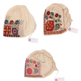
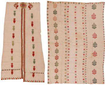
A Greek Island Embroidered Panel+A Greek Island Embroidered CurtainNazmiyal Auctions4.4(34)See Sold PriceFeb 26, 2024
Vintage Framed Pine Island & Lacoste Island MapThe Benefit Shop Foundation Inc.4.3(2.9k)See Sold PriceMar 06, 2024
1683 Sanson Map of the Caribbean -- Les Isles Antilles, &c Entre Lesquelles sont les Lucayes, et lesJasper524.5(9.8k)See Sold PriceFeb 27, 2024
WEST AFRICA Niger/Gambia rivers tribes towns. 'Pays des Negres'. MALLET 1683 mapJasper524.5(9.8k)See Sold PriceFeb 28, 2024
NORTH & WEST AFRICA. Sahara Niger river 'Zaara ou le Desert'. MALLET 1683 mapJasper524.5(9.8k)See Sold PriceFeb 28, 2024
WEST AFRICA. People of Guinea. 'Peuples de Guinée'. Costume. MALLET 1683 printJasper524.5(9.8k)See Sold PriceFeb 28, 2024
WEST AFRICA. Guinea. Nigeria Ghana Benin Togo Sierra Leone. MALLET 1683 mapJasper524.5(9.8k)See Sold PriceFeb 28, 2024
WEST CENTRAL AFRICA. Congo Angola Gabon Cameroon Sao Tome. MALLET 1683 old mapJasper524.5(9.8k)See Sold PriceFeb 28, 2024
NORTH AFRICA. 'Biledulgerid', a former North African country. MALLET 1683 mapJasper524.5(9.8k)See Sold PriceFeb 28, 2024
WEST AFRICA/MAGHREB Tribes Garamantes Getgulie 'Ancienne Libye'. MALLET 1683 mapJasper524.5(9.8k)See Sold PriceFeb 28, 2024
MALLET. Description de l'Univers. Africa. Volume 3 title page. MALLET 1683Jasper524.5(9.8k)See Sold PriceFeb 28, 2024
NORTH AFRICA. Barbary. Morocco Tunisia Libya Egypt. 'Barbarie'. MALLET 1683 mapJasper524.5(9.8k)See Sold PriceFeb 28, 2024
NORTH AFRICA. Morocco Tunisia Libya. 'Mauritanie'. Malta Melita. MALLET 1683 mapJasper524.5(9.8k)See Sold PriceFeb 28, 2024
NUBIA. 'Nubie'. Nile Valley. Sudan Ethiopia Egypt. MALLET 1683 old antique mapJasper524.5(9.8k)See Sold PriceFeb 28, 2024
SUB-SAHARAN AFRICA. 'Ancienne Ethiopie'. Ancient Ethiopia. MALLET 1683 old mapJasper524.5(9.8k)See Sold PriceFeb 28, 2024
SOUTHERN AFRICA Monomotapa (Mutapa Kingdom) Cafrerie (Kaffraria) MALLET 1683 mapJasper524.5(9.8k)See Sold PriceFeb 28, 2024