ATLAS of ANTIENT GEOGRAPHY by SAMUEL BUTLER 1843John McInnis Auctioneers,LLC4.5(505)See Sold PriceFeb 24, 2024
18TH C. ANTIQUE MAP: FRENCH & INDIAN WAR, FRAMEDThomaston Place Auction Galleries4.4(393)See Sold PriceFeb 24, 2024
Rand McNally Railroad Map Cabinet w/ 21 Railroad MapsRail & Road Auctions4.6(165)See Sold PriceMar 08, 2024
Keith Haring - Ink on New York Map, Best Buddies, Inscribed, Signed, and DatedSapphire Auction Gallery4(67)See Sold PriceMar 02, 2024
LATE 17TH C. FRENCH MAP OF THE NEW WORLD BY ALEXIS-HUBERT JAILLOT (1632-1712)Thomaston Place Auction Galleries4.4(393)See Sold PriceFeb 24, 2024
Central Railroad of New Jersey Map of Sandy Hook Route-ca. 1903JM Hobby Supply and Railroad Artifact Auctions4.4(127)See Sold PriceFeb 24, 2024
Lot of Six Mixed Atlas Box Cars-HO Scale-New in BoxJM Hobby Supply and Railroad Artifact Auctions4.4(127)See Sold PriceFeb 25, 2024
Rand McNally/Santa Fe Railroad Map of Iowa-1912JM Hobby Supply and Railroad Artifact Auctions4.4(127)See Sold PriceFeb 24, 2024
NICOLAES VISSCHER (NETHERLANDS, 1618-1709) MAP OF THE NEW WORLDThomaston Place Auction Galleries4.4(393)See Sold PriceFeb 24, 2024
17TH C. WORLD MAP BY NICOLAES VISSCHER (NETHERLANDS, 1618-1709)Thomaston Place Auction Galleries4.4(393)See Sold PriceFeb 24, 2024
Lot of Six Mixed Atlas Cabooses-HO Scale-New in BoxJM Hobby Supply and Railroad Artifact Auctions4.4(127)See Sold PriceFeb 25, 2024
Different Lines of Survey Across Florida Map, 1855Map: Map Showing the Different Lines of Survey Across Florida Maker: A.O.P. Nicholson, Martin Luther Smith/Francis Theodore Bryan/A. E. Drake Publisher: A.O.P. Nicholson 1855 Washington, DC Size: FoliSee Sold Price
SoldVA Manuscript Map & Survey, Westmoreland, 1855.[Virginia/Surveying] “Westmoreland County Va 1855/ I surveyed for Mr John Spillman…” 15 lines signed by surveyor, “James W. English S.W.C.” Upper half of sheet is a manuscript map of a 105 aSee Sold Price
Map of Florida, 1855Map: [Florida] F. Diagram: Explanatory of the Surveys Proposed to Be Executed in the Order of Importance to The Interests Of The Government Maker: General Land Office/A.O.P. Nicholson, John Westcott PSee Sold Price
Sold[MAPS/FLORIDA].[MAPS/FLORIDA]. U.S. Coast Survey. Preliminary Chart Of St. Augustine Harbor Florida. 1862 [but later]. Measures 21 x 22 inches at neat line with wide margins. Mounted to frame under plexiglass with sSee Sold Price
SoldScarce and huge RR map of Florida – 1898Scarce, detailed railroad map of Florida, showing counties, railroad lines, towns, rivers, township surveys, lakes, mountains, creeks, waterfalls, and a much other information. Shows routes for 36 difSee Sold Price
SoldA Framed 19th Century Map of Florida, Height of printA Framed 19th Century Map of Florida, circa 1855, lithography printing by Bowne & Hasbrouck, New York, titled "U.S. Coast Survey...Sketch F... with a General Reconaissance of the Coast of Florida 1848See Sold Price
SoldFlorida Lithograph MapU.S. Coast Survey Sketch F Showing the Progress of the Survey in Section V. A.D. Bache (1806-1867). Lithographed map. Washington, D.C., 1855. 23 x 16 1/2 inches visible, 27 1/4 x 21 1/2 inches framedSee Sold Price
SoldFlorida Lithograph MapA Plat Exhibiting The State of the Surveys in the State of Florida. US Surveyor General. Lithograph. Washington D.C. : 1855. 22 1/2 x 26 inches visible, 35 x 38 inches framedSee Sold Price
Surveys in the State of Florida 1855Map: A Plat Exhibiting the State of the Surveys in The State of Florida With References Maker: A. Hoen & Co. Publishing: Baltimore 1855 Size: 24 x 26.5 inches Map showing towns, townships, topo., traiSee Sold Price
SoldMap, "US Coast Survey, section VII, 1852", showsMap, "US Coast Survey, section VII, 1852", shows coast line of Florida, west of Perdido Bay to St. Marks River, hand colored, 24" x 12", framed.See Sold Price
SoldRoutes across the west 1855Heading: Author: Steptoe, E.J., Rufus Ingalls, et al. Title: Map showing the different routes travelled over by the Detachments of the Overland Command in the Spring of 1855 from Salt Lake City, UtahSee Sold Price
SoldCarrington (R. C., drawn by) & Walker (J. & C.,Carrington (R. C., drawn by) & Walker (J. & C., engravers) Savannah River, Georgia, from the United States Coast Survey 1855, no. 2826, some staining, platemark 670 x 995 mm, 1861; Florida Reefs, CaySee Sold Price
SoldHEREFORDSHIRE MAP FRAMED J. ARTHUR MAP MAKER U.K.Antique British hand colored map of the county of Herefordshire in England, UK. The map was drawn and created by the English map maker, J. Archer. Fold line across middle. Map appears to have hand draSee Sold Price
HEREFORDSHIRE MAP FRAMED J. ARTHUR MAP MAKER U.K.Antique British hand colored map of the county of Herefordshire in England, UK. The map was drawn and created by the English map maker, J. Archer. Fold line across middle. Map appears to have hand draSee Sold Price
Antique Land Office Survey Map of Louisiana, 1855Title/Content of Map: 1855 Land Office Survey Map of Louisiana -- (H) Map of Louisiana Representing the Several Land Districts Prepared to Accompany the Surveyor Generals Report Date Printed: 1855 NewSee Sold Price
1855 Survey Map of South Farallon IslandU.S. Coast Survey map "Sketch of South Farallon Island". Includes 3 landscape illustrations. Good condition with areas of some age toning, etc. Folds as issued. 15" x 14.5"See Sold Price
Antique Land Office Survey Map of Louisiana, 1855Title/Content of Map: 1855 Land Office Survey Map of Louisiana -- (H) Map of Louisiana Representing the Several Land Districts Prepared to Accompany the Surveyor Generals Report Date Printed: 1855 NewSee Sold Price
Antique Land Office Survey Map of Louisiana, 1855Title/Content of Map: 1855 Land Office Survey Map of Louisiana -- (H) Map of Louisiana Representing the Several Land Districts Prepared to Accompany the Surveyor Generals Report Date Printed: 1855 NewSee Sold Price
SoldLOT OF 3 ANTIQUE MAPS 1850 FLORIDA SURVEY MAPSTwo 1850's North Florida survey maps, Arredondo Grant and South Boundary of General Coffees Survey. Both framed, measuring 15 X 8 inches. Lot also includes Diagram of Tallahassee Land District map, frSee Sold Price
SoldST MARKS APALACHICOLA CHIPOLA MAP & EPHEMERA LOTIncludes 1852 ST. Marks Florida Survey map, John W. Tullis & Co. 1886 Eufaula, Alabama letter, Chipola Canal Co. 1828 Act, Andrew Jackson plate, town of Apalachicola U.S. Coast Survey map, 1860's postSee Sold Price
Vintage Florida Topography Maps War DepartmentVintage Florida Topography Maps War Department This is a set of four Topography Florida survey maps done by the War Department Corps of Engineers in the 1910s. These are vintage reprints of the 1910sSee Sold Price
Vintage Florida Topography Maps War DepartmentVintage Florida Topography Maps War Department This is a set of four Topography Florida survey maps done by the War Department Corps of Engineers in the 1910s. These are vintage reprints of the 1910sSee Sold Price
Vintage Florida Topography Maps War DepartmentVintage Florida Topography Maps War Department This is a set of four Topography Florida survey maps done by the War Department Corps of Engineers in the 1910s. These are vintage reprints of the 1910sSee Sold Price
Sold1855 Colton Map of Florida -- FloridaReserve Reduced! Title/Content of Map: 1855 Colton Map of Florida -- Florida Date: 1855, New York Cartographer: J Colton Size: 11.8 X 14.5 in. This is an outstanding Florida map. It features only thirSee Sold Price
Michigan Southern and Northern Indiana RR 14th Annual Report-February 28, 1869JM Hobby Supply and Railroad Artifact Auctions4.4(127)See Sold PriceFeb 24, 2024
1875 Rand Avery and Co. Map of Express Companies and Railroads of the USA and CanadaJM Hobby Supply and Railroad Artifact Auctions4.4(127)See Sold PriceFeb 24, 2024
Grand Trunk Railroad Across the Continent Through Canada Book-1917JM Hobby Supply and Railroad Artifact Auctions4.4(127)See Sold PriceFeb 24, 2024
Union Pacific RR Across The Continent West From Omaha, NE Book-April 2, 1868JM Hobby Supply and Railroad Artifact Auctions4.4(127)See Sold PriceFeb 24, 2024
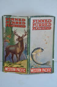
Western Pacific RR Finned Furred Feathered Brochure-1912JM Hobby Supply and Railroad Artifact Auctions4.4(127)See Sold PriceFeb 24, 2024
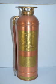
Rock Island RR Large Copper and Brass Fire ExtinguisherJM Hobby Supply and Railroad Artifact Auctions4.4(127)See Sold PriceFeb 24, 2024
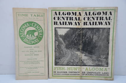
Algoma Central RY March 12, 1944 Public Timetable and BrochureJM Hobby Supply and Railroad Artifact Auctions4.4(127)See Sold PriceFeb 24, 2024
Joseph Martin Kronheim Pair Early Color Glamor Prints c1850Luis Porretta Fine Arts4.3(10)See Sold PriceMar 02, 2024
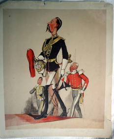
JOSEPH MARTIN KRONHEIM - "Captain Of The Blues" Early Colore Printing MilitaryLuis Porretta Fine Arts4.3(10)See Sold PriceMar 02, 2024
The Holy Land Tours - Hamburg American Line - 1911Levy Auction House4.3(11)See Sold PriceFeb 27, 2024
Fifteen New Old Stock Chicago & Northwestern Railroad Playing Card DecksRail & Road Auctions4.6(165)See Sold PriceMar 08, 2024
SOUTHERN AFRICA Monomotapa (Mutapa Kingdom) Cafrerie (Kaffraria) MALLET 1683 mapJasper524.5(9.9k)See Sold PriceFeb 28, 2024
Virginia and West Virginia Topography MapsRapid Estate Liquidators and Auction Gallery4.5(1.1k)See Sold PriceFeb 28, 2024


![[MAPS/FLORIDA]. (1 of 0)](https://p1.liveauctioneers.com/dist/images/placeholder.jpg?height=282&quality=70)