SoldMAP: c. 1861, Johnsons Double HemisphereHistoric Maps"Johnson's Western & Eastern Hemisphere" Circa 1861 c. 1861, "Johnson's Western Hemisphere" and "Johnson's Eastern Hemisphere," Printed on 1 sheet, pubSee Sold Price
SoldMAP: c. 1861, Johnsons Double HemisphereHistoric Maps"Johnson's Western & Eastern Hemisphere" Circa 1861 c. 1861, "Johnson's Western Hemisphere" and "Johnson's Eastern Hemisphere," Printed on 1 sheet, pubSee Sold Price
SoldMAP: c. 1861, Johnsons Double HemisphereHistoric Maps"Johnson's Western & Eastern Hemisphere" Circa 1861 c. 1861, "Johnson's Western Hemisphere" and "Johnson's Eastern Hemisphere," Printed on 1 sheet, pubSee Sold Price
SoldMAP: c. 1861, Johnsons Double HemisphereHistoric MapsJohnson’s Western & Eastern Hemisphere" Circa 1861 c. 1861, "Johnson’s Western Hemisphere" and "Johnson’s Eastern Hemisphere," Printed on 1 sheet, published by Johnson aSee Sold Price
SoldMAP: c. 1861, Johnsons Double HemisphereMaps“Johnson’s Western & Eastern Hemisphere” Circa 1861 c. 1861, “Johnson’s Western Hemisphere” and “Johnson’s Eastern Hemisphere,” Printed on 1 sSee Sold Price
SoldMAP: c. 1861, Johnsons Double HemisphereHistoric Maps"Johnson's Western & Eastern Hemisphere" Circa 1861 c. 1861, "Johnson's Western Hemisphere" and "Johnson's Eastern Hemisphere," Printed on 1 sheet, pubSee Sold Price
SoldMAP: c. 1861, Johnsons Double HemisphereHistoric Maps"Johnson's Western & Eastern Hemisphere" Circa 1861 c. 1861, "Johnson's Western Hemisphere" and "Johnson's Eastern Hemisphere," Printed on 1 sheet, pubSee Sold Price
1861. World Map in Double Hemisphere Projection. By Johnson and BrowningTitle: 1861. World Map in Double Hemisphere Projection. By Johnson and Browning Date/Period: 1861 Materials: Steel engraved Size: 26 x 18” This hand-colored, steel-engraved map was created by JoSee Sold Price
1861 World in double hemisphereTitle: 1861 World in double hemisphere Date/Period: 1861 Materials: Steel engraved. Size: 27x17 3/4” By A. J. Johnson & J. H Colton. From 'Johnson's New Illustrated Family Atlas' published in New YoSee Sold Price
1861 World in double hemisphereTitle: 1861 World in double hemisphere Date/Period: 1861 Materials: Steel engraved. Size: 27x17 3/4” By A. J. Johnson & J. H Colton. From 'Johnson's New Illustrated Family Atlas' published in New YoSee Sold Price
1861 World in double hemisphereTitle: 1861 World in double hemisphere Date/Period: 1861 Materials: Steel engraved. Size: 27x17 3/4” By A. J. Johnson & J. H Colton. From 'Johnson's New Illustrated Family Atlas' published in New YoSee Sold Price
1861 World in double hemisphereTitle: 1861 World in double hemisphere Date/Period: 1861 Materials: Steel engraved. Size: 27x17 3/4” By A. J. Johnson & J. H Colton. From 'Johnson's New Illustrated Family Atlas' published in New YoSee Sold Price
1861 World in double hemisphereTitle: 1861 World in double hemisphere Date/Period: 1861 Materials: Steel engraved. Size/Dimensions: 27x17 3/4” Description: By A. J. Johnson & J. H Colton. From 'Johnson's New Illustrated Family AtSee Sold Price
Sold1861 Civil War military map in full hand-colorLarge format, double-page “Johnson’s New Military Map of the United States showing the Forts, Military Posts &c. with Enlarged Plans of Southern Harbors” by Johnson and Ward. Original and vividSee Sold Price
SoldMap, c. 1861, Johnsons Missouri and KansasMaps“Johnson’s Missouri and Kansas” Map with Vignettes c. 1861, “Johnson’s Missouri and Kansas,” published by Johnson and Ward, New York, Choice Extremely Fine. FroSee Sold Price
SoldMap, c. 1861, Johnsons North AmericaMaps“Johnson’s North America” Published Circa 1861 c. 1861, “Johnson’s North America,” published by Johnson & Browning, Very Fine. From the Johnson’s Family ASee Sold Price
SoldMap, c. 1861, Johnsons Missouri and KansasHistoric Maps"Johnson's Missouri and Kansas" Map with Vignettes c. 1861, "Johnson's Missouri and Kansas," published by Johnson and Ward, New York, Choice Extremely Fine. From tSee Sold Price
SoldMap, c. 1861, Johnsons Missouri and KansasMaps“Johnson’s Missouri and Kansas” Map with Vignettes c. 1861, “Johnson’s Missouri and Kansas,” published by Johnson and Ward, New York, Choice Extremely Fine. FroSee Sold Price
SoldMap, c.1861, Johnsons North AmericaMaps“Johnson’s North America” Published Circa 1861 c. 1861, “Johnson’s North America,” published by Johnson & Browning, Very Fine. From the Johnson’s Family ASee Sold Price
SoldMAP: Johnsons, Michigan and Wisconsin, c. 1861Maps“Johnson’s Michigan and Wisconsin” Map c. 1861, “Johnson’s Michigan and Wisconsin,” published by Johnson & Browning, Very Fine. From the Johnson’s FamilySee Sold Price
SoldMAP: Johnsons, Michigan and Wisconsin, c. 1861Historic Maps“Johnson’s Michigan and Wisconsin” Map c. 1861, “Johnson’s Michigan and Wisconsin,” published by Johnson & Browning, Very Fine. From the Johnson’See Sold Price
SoldMAP: Johnsons New Jersey, c. 1861Historic Mapsc. 1861 "Johnson's New Jersey" Map c. 1861, "Johnson's New Jersey," published by Johnson & Browning, Choice Extremely Fine. From the Johnson's Family Atlas, meSee Sold Price
SoldMAP: Johnsons New Jersey, c. 1861Historic Mapsc. 1861 "Johnson's New Jersey" Map c. 1861, "Johnson's New Jersey," published by Johnson & Browning, Choice Extremely Fine. From the Johnson's Family Atlas, meSee Sold Price
SoldMAP: Johnsons New Jersey, c. 1861Historic Mapsc. 1861 "Johnson's New Jersey" Map c. 1861, "Johnson's New Jersey," published by Johnson & Browning, Choice Extremely Fine. From the Johnson's Family Atlas, meSee Sold Price
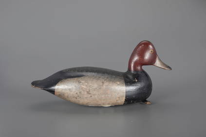
JEB Rig Redhead Drake Decoy by Harry V. Shourds (1861-1920)Copley Fine Art Auctions4.5(40)See Sold PriceFeb 24, 2024
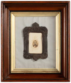
The O'Brien Shourds Winter-Plumage Plover Decoy by Harry V. Shourds (1861-1920)Copley Fine Art Auctions4.5(40)See Sold PriceFeb 24, 2024
17TH C. WORLD MAP BY NICOLAES VISSCHER (NETHERLANDS, 1618-1709)Thomaston Place Auction Galleries4.4(386)See Sold PriceFeb 24, 2024
COVENS & MORTIER 1745 MAP OF THE GLOBEThomaston Place Auction Galleries4.4(386)See Sold PriceFeb 24, 2024
17TH C. MAP OF THE BERKSHIRES BY JOHN SPEED, FRAMEDThomaston Place Auction Galleries4.4(386)See Sold PriceFeb 24, 2024
OGILVY & BOWEN c1736 Original Map of Oxfordshire Berkshire Etc.Luis Porretta Fine Arts4.3(10)See Sold PriceMar 02, 2024
1872 Holy BIBLE & Hitchcock Analysis Gruden Concordance Theology MAPS Holy LandSchilb Antiquarian Rare Books4.8(421)See Sold PriceMar 31, 2024