ATLAS of ANTIENT GEOGRAPHY by SAMUEL BUTLER 1843John McInnis Auctioneers,LLC4.6(504)See Sold PriceFeb 24, 2024
18TH C. ANTIQUE MAP: FRENCH & INDIAN WAR, FRAMEDThomaston Place Auction Galleries4.4(389)See Sold PriceFeb 24, 2024
Rand McNally Railroad Map Cabinet w/ 21 Railroad MapsRail & Road Auctions4.6(165)See Sold PriceMar 08, 2024
Keith Haring - Ink on New York Map, Best Buddies, Inscribed, Signed, and DatedSapphire Auction Gallery4.1(67)See Sold PriceMar 02, 2024
LATE 17TH C. FRENCH MAP OF THE NEW WORLD BY ALEXIS-HUBERT JAILLOT (1632-1712)Thomaston Place Auction Galleries4.4(389)See Sold PriceFeb 24, 2024
Central Railroad of New Jersey Map of Sandy Hook Route-ca. 1903JM Hobby Supply and Railroad Artifact Auctions4.4(126)See Sold PriceFeb 24, 2024
Lot of Six Mixed Atlas Box Cars-HO Scale-New in BoxJM Hobby Supply and Railroad Artifact Auctions4.4(126)See Sold PriceFeb 25, 2024
Rand McNally/Santa Fe Railroad Map of Iowa-1912JM Hobby Supply and Railroad Artifact Auctions4.4(126)See Sold PriceFeb 24, 2024
NICOLAES VISSCHER (NETHERLANDS, 1618-1709) MAP OF THE NEW WORLDThomaston Place Auction Galleries4.4(389)See Sold PriceFeb 24, 2024
17TH C. WORLD MAP BY NICOLAES VISSCHER (NETHERLANDS, 1618-1709)Thomaston Place Auction Galleries4.4(389)See Sold PriceFeb 24, 2024
Lot of Six Mixed Atlas Cabooses-HO Scale-New in BoxJM Hobby Supply and Railroad Artifact Auctions4.4(126)See Sold PriceFeb 25, 2024
Sold1883 Hardesty Map of Northern Dakota -- Map ofReserve Reduced! Title/Content of Map: 1883 Hardesty Map of Northern Dakota -- Map of Dakota-Northern Portion Date: 1883, Chicago Cartographer: H. Hardesty Size: 12.7 X 18.5 in. A nice county map of tSee Sold Price
1883 Hardesty Map of Northern DakotaDescription: 1883 Hardesty Map of Northern Dakota -- Map of Dakota-Northern Portion. H. Hardesty, 1883, Chicago, A nice county map of today's North Dakota. Detailed with settlements, military and IndiSee Sold Price
1883 Hardesty Map of Northern Dakota -- Map ofTitle/Content of Map: 1883 Hardesty Map of Northern Dakota -- Map of Dakota-Northern Portion Date Printed: 1883, Chicago Cartographer: H. Hardesty Size: 12.7 X 18.5 in. A nice county map of today's NoSee Sold Price
Hardesty: Map of Northern Dakota, 1883Map: 1883 Hardesty Map of Northern Dakota -- Map of Dakota-Northern Portion Cartographer: H. Hardesty Year / Place: 1883, Chicago Map Dimensions: 12.7 X 18.5 Condition: Excellent. Slight toning and aSee Sold Price
Hardesty: Antique Map of Northern Dakota, 1883Title/Content of Map: 1883 Hardesty Map of Northern Dakota -- Map of Dakota-Northern Portion Date Printed: 1883, Chicago Cartographer: H. Hardesty Size: 12.7 X 18.5 in. A nice county map of today's NoSee Sold Price
SoldHardesty: Antique Map of Dakota-Northern, 1883Title: Map of Dakota-Northern by Hardesty Date: 1883 Medium: Wax Engraving Dimensions (in): 21 x 14.5 Condition: Great Condition No Reserve: This lot starts at $1 and has no reserve as a courtesy so tSee Sold Price
SoldHardesty: Antique Map of Dakota-Southern Portion, 1883Title: Map of Dakota-Southern Portion by Hardesty Date: 1883 Medium: Wax Engraving Dimensions (in): 21 x 14.5 Condition: Excellent Condition No Reserve: This lot starts at $1 and has no reserve as a cSee Sold Price
Map of Dakota - Southern Portion. | Northern Portion.Publication Date: 1883 Title: Map of Dakota - Southern Portion. | Northern Portion. Cartographer: RAND, MCNALLY & CO. Publisher: H.H. HARDESTY & CO. Height: 12.8 Width: 18.5 190-195. Railroads named aSee Sold Price
SoldHardesty Map of Nebraska, 1883Title: 1883 Hardesty Map of Nebraska Cartographer: H Hardesty Published: 1883, Chicago Measurements: 12.8 X 18.8 in. Map of Nebraska. A nice county map of Nebraska. Detailed with settlements, and railSee Sold Price
1882 Rand McNally Map of Northern DakotaTitle/Content of Map: 1882 Rand McNally Map of Northern Dakota -- Rand McNally & Company's Indexed Atlas of the World (Dakota) Date Printed: 1882, Chicago Cartographer: Rand McNally Size: 12.7 X 18.5See Sold Price
1882 Rand McNally Map of Northern Dakota -- RandTitle: 1882 Rand McNally Map of Northern Dakota -- Rand McNally & Company's Indexed Atlas of the World (Dakota) Date: 1882, Chicago Cartographer: Rand McNally Size: 12.7 X 18.5 Additional Information:See Sold Price
1882 Rand McNally Map of Northern Dakota -- RandTitle/Content of Map: 1882 Rand McNally Map of Northern Dakota -- Rand McNally & Company's Indexed Atlas of the World (Dakota) Date: 1882, Chicago Cartographer: Rand McNally Size: 12.7 X 18.5 A nice cSee Sold Price
1883 Map of DakotaAuthor: Cram Title: 1883 Map of Dakota Medium: Ink on Paper Dimensions: 13.5"X22" Description: Map of the Dakota territory dated 1883. Printed and published by George Cram in Chicago. Part of his WorlSee Sold Price
1882 Rand McNally Map of Northern Dakota -- RandTitle/Content of Map: 1882 Rand McNally Map of Northern Dakota -- Rand McNally & Company's Indexed Atlas of the World (Dakota) Date Printed: 1882, Chicago Cartographer: Rand McNally Size: 12.7 X 18.5See Sold Price
SoldHardesty: Antique Map Nebraska Dakota Montana WyomingScarce 1875 Hardesty map of Nebraska, Dakota, Montana & Wyoming. From the scarce Jones and Hamilton Illustrated Historical Atlas of the World Illustrated. Large format hand-colored map shows TerritorySee Sold Price
J. H. Colton: Rhode Island MapRhode Island Hardesty 1883 Map, 10.75 x 14.5 in Please note that this lot has a confidential reserve. When you leave a bid in advance of the auction, submit your maximum. Jasper52 will bid on your behSee Sold Price
J. H. Colton: Utah MapUtah, Hardesty Hardesty 1883 Map, 14.75 x 21 in Please note that this lot has a confidential reserve. When you leave a bid in advance of the auction, submit your maximum. Jasper52 will bid on your behSee Sold Price
SoldJ. H. Colton: Wyoming MapJ. H. Colton Map Wyoming Hardesty 1883 Map, 14.5 x 10.75 in Please note that this lot has a confidential reserve. When you leave a bid in advance of the auction, submit your maximum. Jasper52 will bidSee Sold Price
Map Of TexasMap Of Texas Map: H.H. Hardesty, 1883, Folio, 211-223. Includes Panhandle, Western Part, Eastern Part And Southern Texas. Shows Railroads. Please note that this lot has a confidential reserve. When yoSee Sold Price
SoldHardesty: Map of Jerusalem, 18831883 h/c map of Jerusalem published by H. H. Hardesty. 9.5 x 13.5. Detailed topographic map of the center of the world’s religions. Nicely centered with no apparent faults. Please note that thisSee Sold Price
SoldHardesty's World Map, 1883Map of the World by Hardesty 1883 Size: 20.75 x 14.5 in No Reserve: This lot starts at $1 and has no reserve as a courtesy so that collectors can determine the true market value on this authentic itemSee Sold Price
SoldHardesty: Map of Oregon, 1883Map: Oregon Maker: Hardesty 1883 21 x 14.75 in Please note that this lot has a confidential reserve. When you leave a bid in advance of the auction, submit your maximum. Jasper52 will bid on your behaSee Sold Price
SoldTWELVE GREAT NORTHERN NORTH DAKOTA MAPSFoldout rail line maps by Great Northern. Unused.See Sold Price
SoldHardesty Quebec MapMap of Quebec, Hardesty, 1883, 20.75 x 14.5 in Please note that this lot has a confidential reserve. When you leave a bid in advance of the auction, submit your maximum. Jasper52 will bid on your behaSee Sold Price
Crams Map of North Dakota-Complete Railroad System and County Map-1907JM Hobby Supply and Railroad Artifact Auctions4.4(126)See Sold PriceFeb 24, 2024
Northern Pacific RR Washington and Northern Idaho Map Folder-1941JM Hobby Supply and Railroad Artifact Auctions4.4(126)See Sold PriceFeb 24, 2024
Westland Oil Company North Dakota Road MapCheck the Oil Promotions, LLC4.6(305)See Sold PriceFeb 25, 2024
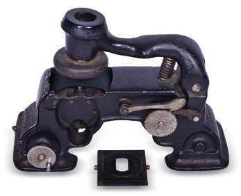
Great Northern Railway Hoople, North Dakota Ticket Dater Die and Centennial MachineRail & Road Auctions4.6(165)See Sold PriceMar 07, 2024
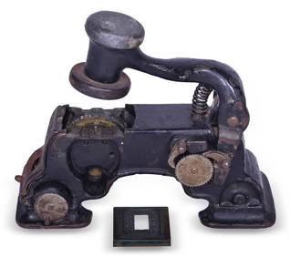
Great Northern Railway Niagara, North Dakota Ticket Dater Die and Centennial MachineRail & Road Auctions4.6(165)See Sold PriceMar 07, 2024
D'Entrecasteaux - Tasmania, Australia: Map of the Northern Portion of Recherche Bay. 5Trillium Antique Prints & Rare Books4.5(30)See Sold PriceFeb 24, 2024
1816 MAP NORTHERN PART OF RUSSIA or MUSCOVY in EUROPE copper engraving ANTIQUEJasper524.5(9.8k)See Sold PriceFeb 27, 2024
1764 Bellin Map of Lesser Antilles Northern Portion -- Petites Antilles ou Isles du Vent 3e. Partie.Jasper524.5(9.8k)See Sold PriceFeb 27, 2024
North & West Africa. Dahomey. Gold Coast. Military Territory. THE TIMES 1922 mapJasper524.5(9.8k)See Sold PriceFeb 28, 2024
NORTHERN AFRICA. Morocco Tunisia Algeria. Caravan routes.TALLIS/RAPKIN 1851 mapJasper524.5(9.8k)See Sold PriceFeb 28, 2024
Vacheron Constantin Overseas World Time 43.5 mm Steel Mens WatchGolden Gate Auctioneer4.1(275)See Sold PriceFeb 24, 2024
"Map of the Parishes of Iberville Most of West Baton Rouge and Including Parts of the Parishes ofCrescent City Auction Gallery4.3(231)See Sold PriceMar 09, 2024
Francis McNally - Antique Map of Nebraska, Kansas, Dakota, Colorado & MontanaProverde Auctions4.3(3)See Sold PriceFeb 28, 2024
Vintage Map of Roman Forum - Vatican City - Versailles parkProverde Auctions4.3(3)See Sold PriceFeb 28, 2024
1921 USGS Topographic Map of North DakotaRapid Estate Liquidators and Auction Gallery4.5(1.1k)See Sold PriceFeb 27, 2024