Official Map of Cuba, 1898Official Map of Cuba. THE FORT DEARBORN PUBLISHING CO., CRAM, GEORGE F., 1898, Folio - 13.00 H x 20.00 W Inches, Reprint of an atlas map folded into buff printed wraps. Wrapper title: Pocket map of CuSee Sold Price
Cram: Antique Official Atlas Map of Cuba, 1898Map: Official Map of Cuba Publication Date: 1898 Authors: THE FORT DEARBORN PUBLISHING CO., CRAM, GEORGE F. Publisher: THE FORT DEARBORN PUBLISHING CO. Size: Folio – 13.00 H x 20.00 W Inches ReprintSee Sold Price
Antique Long Military Map of Cuba, 1898Map: Cuba Part of Chart "E" (Special Edition), Long Military Map of Cuba Publication Date: 1898-07-01 Authors: USCGS, U.S. COAST AND GEODETIC SURVEY Publisher: USCGS Size: Long Folio – 16.50 H x 41.See Sold Price
SoldOfficial Map of CubaTitle/Content of Map: Official Map of Cuba Date: c1898 Cartographer: CRAM, GEORGE F. Publisher: GEO. F. CRAM, Size: 13Height - 20.25Width Double-page atlas map with inset plan of Havana. On reverse, mSee Sold Price
1898 c. Cram Map of Superior WI, verso Omaha and SiouxTitle/Content of Map: 1898 c. Cram Map of Superior WI, verso Omaha and Sioux City -- City of Superior, Wis.; Verso: Omaha; Verso: Official map of Sioux City Date: 1898 c., Chicago Cartographer: G CramSee Sold Price
1898 c. Cram Map of Superior WI, verso Omaha and SiouxTitle/Content of Map: 1898 c. Cram Map of Superior WI, verso Omaha and Sioux City -- City of Superior, Wis.; Verso: Omaha; Verso: Official map of Sioux City Date: 1898 c., Chicago Cartographer: G CramSee Sold Price
1898 c. Cram Map of Superior WI, verso Omaha and SiouxTitle/Content of Map: 1898 c. Cram Map of Superior WI, verso Omaha and Sioux City -- City of Superior, Wis.; Verso: Omaha; Verso: Official map of Sioux City Date: 1898 c., Chicago Cartographer: G CramSee Sold Price
1898 c. Cram Map of Superior WI, verso Omaha and SiouxTitle/Content of Map: 1898 c. Cram Map of Superior WI, verso Omaha and Sioux City -- City of Superior, Wis.; Verso: Omaha; Verso: Official map of Sioux City Date: 1898 c., Chicago Cartographer: G CramSee Sold Price
3 MAPS: SANTIAGO DE CUBA; MANILA, & WARSHIPSLOT OF 3 MAPS: SANTIAGO DE CUBA, C. 1898; MANILA, C. 1898 & WARSHIPS, 9" X 27" TO 17" X 23":!7 1/4" x 23", 21 1/2" x 10 1/2" and 9" x 27 1/2".See Sold Price
1898 c. Cram Map of Superior WI, verso Omaha and SiouxTitle/Content of Map: 1898 c. Cram Map of Superior WI, verso Omaha and Sioux City -- City of Superior, Wis.; Verso: Omaha; Verso: Official map of Sioux City Date Printed: 1898 c., Chicago CartographerSee Sold Price
Cram: Antique Map of Superior WI, 1898Title/Content of Map: 1898 c. Cram Map of Superior WI, verso Omaha and Sioux City -- City of Superior, Wis.; Verso: Omaha; Verso: Official map of Sioux City Date Printed: 1898 c., Chicago CartographerSee Sold Price
Sold(2) SPANISH-AMERICAN WAR BOOKS, WHITE - 1898White, Trumbull; (1) "Our War with Spain for Cuba's Freedom"; Freedom publishing Co.; copyrighted by K. T /boland 1898; includes map of Cuba; cover has very minor edge wear; pages are toned with minorSee Sold Price
1898 Rand McNally Map of Cuba -- CubaTitle/Content of Map: 1898 Rand McNally Map of Cuba -- Cuba Cartographer: Rand McNally Year/Place: 1898, Chicago Size: 12.3 X 18.6 in when combined This is a highly detailed map of Cuba on two pages wSee Sold Price
1898 Rand McNally Map of Cuba -- CubaTitle: 1898 Rand McNally Map of Cuba -- Cuba Cartographer: Rand McNally Year / Place: 1898, Chicago Map Dimension (in.): 12.3 X 18.6 in when combined This is a highly detailed map of Cuba on two pagesSee Sold Price
1898 Rand McNally Map of Cuba -- CubaTitle/Content of Map: 1898 Rand McNally Map of Cuba -- Cuba Cartographer: Rand McNally Year/Place: 1898, Chicago Size: 12.3 X 18.6 in when combined This is a highly detailed map of Cuba on two pages wSee Sold Price
SoldA COLLECTION OF RAILROAD PAPER EPHEMERAIncluding a 1956 Handlan lanterns catalog, tourist brochures, timetables, Railroad Picture Book copyright 1898, transit maps, 1968 The Official Guide of the Railways, and more. We happily provide seamSee Sold Price
Cuba Part of Chart "E" 1898Map: Cuba Part of Chart "E" Maker: U.S. Coast and Geodetic Survey Publishing: Washington DC 1898 Size: 16.5 x 41 inches Detailed topographic map showing roads and railroads, all towns. Excellent largeSee Sold Price
Cuba 1898Title/Content of Map: Cuba 1898 Date Printed: 1898 Material/Medium: Paper Size: approx 21.5 x 14 inches Rand McNally New Business Atlas, Philadelphia Reserve: $35.00 Shipping: Domestic: Flat-rate ofSee Sold Price
Spanish-American War. April-June 1898 Santiago de Cuba Campaign 1959 old mapTITLE/CONTENT OF MAP: 'The Spanish-American War - Spanish Dispositions 20 June 1898 // The Spanish-American War - Santiago Campaign Initial Operations, 22-24 June 1898 // The Spanish American War - NaSee Sold Price
Cuba 1898Title/Content of Map: Cuba 1898 Date Printed: 1898 Material/Medium: paper Size: 21.5 x 14 inches Additional Info: Rand McNally Business Atlas Reserve: $35.00 Shipping: Domestic: Flat-rate of $15.00 tSee Sold Price
SoldRare map of Kern County 1898Heading: (California - Kern County) Author: Congdon, Charles H. Title: Official Map of Kern County California Compiled from Public Records and Private Surveys Place Published: [San Francisco] PublisheSee Sold Price
SoldLarge Map of Kern County, CA 1898Heading: (California - Kern County) Author: Congdon, Cha[rle]s H. Title: Official Map of Kern County California Compiled from Public Records and Private Surveys Place Published: Publisher:W.B. WalkupSee Sold Price
Large Map of Kern County, CA 1898Title: Official Map of Kern County California Compiled from Public Records and Private Surveys Author: Congdon, Cha[rle]s H. Description: Map in three loose panels comprising of a left, middle and rigSee Sold Price
Spanish-American War. April-June 1898 Santiago de Cuba Campaign 1959 old mapTITLE/CONTENT OF MAP: 'The Spanish-American War - Spanish Dispositions 20 June 1898 // The Spanish-American War - Santiago Campaign Initial Operations, 22-24 June 1898 // The Spanish American War - NaSee Sold Price
Crams Township and Railroad Map of Pennsylvania-1898JM Hobby Supply and Railroad Artifact Auctions4.4(126)See Sold PriceFeb 24, 2024
Official Railroad Map of Kansas-1907JM Hobby Supply and Railroad Artifact Auctions4.4(126)See Sold PriceFeb 24, 2024
The Complete History of World War II 1948North American Artifact Auctions4.6(184)See Sold PriceApr 20, 2024
An "Official Disneyland Road Map" Richfield Brochure.Van Eaton Galleries4.6(99)See Sold PriceMar 02, 2024
Map of Part of the West Indies, Etc., Showing the Exact Position Of The U.S. War Steamer SanJasper524.5(9.8k)See Sold PriceFeb 27, 2024
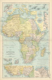
NORTH & COLONIAL WEST AFRICA. Nigeria marked as "Royal Niger Company" 1898 mapJasper524.5(9.8k)See Sold PriceFeb 28, 2024
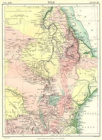
NILE VALLEY. Sudan Tanzania Ethiopia Uganda Lake Victoria. Britannica. 1898 mapJasper524.5(9.8k)See Sold PriceFeb 28, 2024
Algeria Morocco & Tunis. North Africa. Tunisia. Maghreb. BARTHOLOMEW 1898 mapJasper524.5(9.8k)See Sold PriceFeb 28, 2024
COLONIAL CENTRAL AFRICA. Congo German East Africa Rhodesia. BARTHOLOMEW 1898 mapJasper524.5(9.8k)See Sold PriceFeb 28, 2024
AFRICA. Africa. Britannica 9th edition 1898 old antique vintage map plan chartJasper524.5(9.8k)See Sold PriceFeb 28, 2024
AFRICA French Congo State Soudan Nile Delta Suez canal by GW BACON 1898 mapJasper524.5(9.8k)See Sold PriceFeb 28, 2024
Two Hand-Colored 19th Century Maps of New Orleans and Louisiana, Larger- H.- 12 1/2 in., W.- 15 1/2Crescent City Auction Gallery4.3(231)See Sold PriceMar 08, 2024
Vintage 1920s Rand McNally Auto Trails MapThe Benefit Shop Foundation Inc.4.3(2.9k)See Sold PriceMar 20, 2024